

Three-dimensional geological modeling of Cenozoic erathem in Jiangsu segment of the Tanlu fault zone
-
摘要:
本文基于SKUA-GOCAD三维建模软件平台的构造-地层实体建模流程,通过整合研究区大量地质、地球物理资料和数据利用地质时间域坐标系转换和离散光滑插值(DSI)技术,并结合非定量化的地质基础利用地质网格功能建立了郯庐断裂带江苏段新生界的三维地质构造模型,该模型包括地表、第四系底部、新近系底部和基岩顶部等四个层面的地层模型和断层模型。该模型定量化地给出了研究区第四系、新近系底界的三维结构和特征,并刻画了主要活动断裂的三维空间分布,通过该模型可以更直观地显示研究区新生代地层单元和断裂的变化规律,对深入分析活动断裂带的沉积与构造具有重要的意义。
Abstract:The establishment of three-dimensional geological structure model of active fault zones is an important basis for studying active faults, earthquake and geological disasters. Based on the tectonic-stratigraphic entity model flow of the 3D modeling platform SKUA-GOCAD, the UVT and DSI techniques in the geological time domain are used in this study. A 3D geological structure model of the Neogene in the Jiangsu segment of the Tanlu fault system is established, combined with the non-quantified geological foundation and the geological grid function. The three-dimensional model includes fault model and strata model with four layers (the surface, Quaternary bottom, Neogene bottom and bedrock top surface). The 3D model of Cenozoic erathem in Jiangsu segment of Tanlu fault zone gives the 3D structure and characteristics of Quaternary and Neogene basement quantitatively, and describes the 3D spatial distribution of main active faults. The three-dimensional model can more intuitively understand the Cenozoic stratigraphic units and faults in the studied area, which is of great significance to the in-depth analyses on the sedimentation and structure of active fault zones.
-
江苏省地质矿产局. 1995. 郯城县幅1 ∶ 50 000地质图、基岩地质图说明书. 12−36.江苏省地质矿产局. 1995. 王庄镇幅1 ∶ 50 000地质图、基岩地质图说明书. 12−40.江苏省地质矿产局. 1995. 晓店幅1 ∶ 50 000地质图、基岩地质图说明书. 11−38.江苏省地质矿产局. 1995. 宿迁市幅1 ∶ 50 000地质图、基岩地质图说明书. 10−35.江苏省地质局. 1980. 新沂幅1 ∶ 20万区域水文地质普查报告. 12−27.江苏省地质局. 1980. 宿迁幅1 ∶ 20万区域水文地质普查报告. 13−21.
-
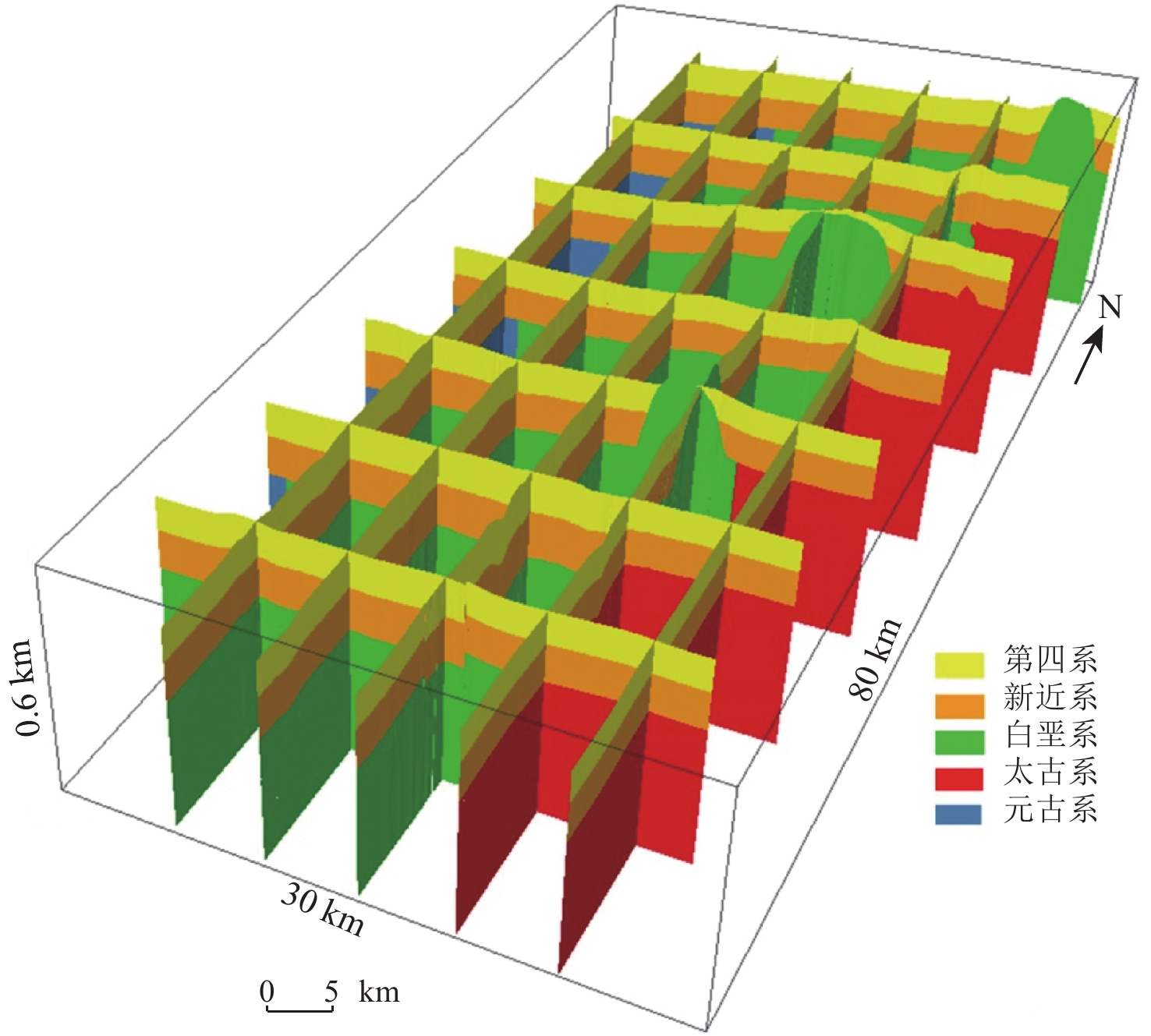
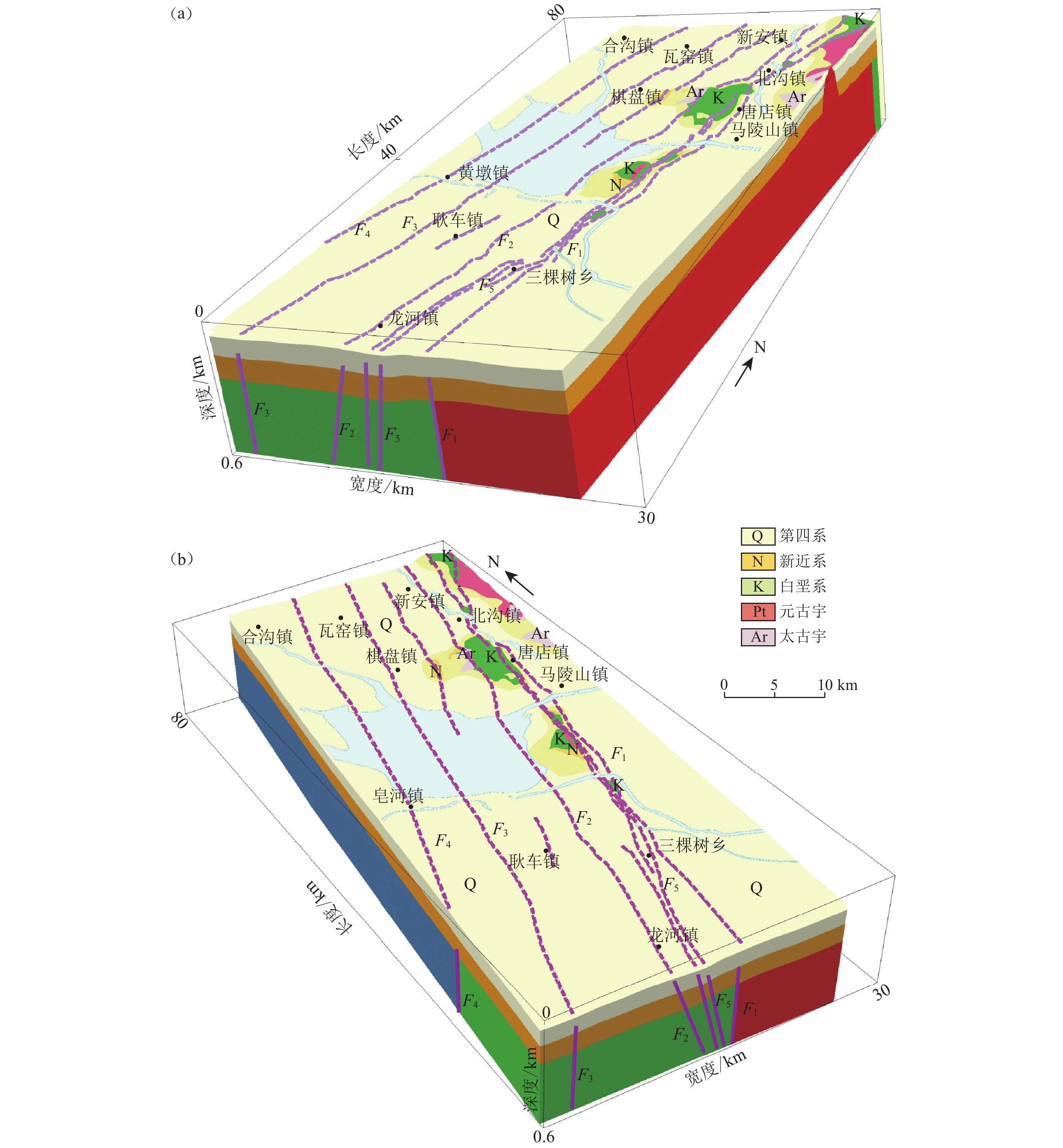
![]()
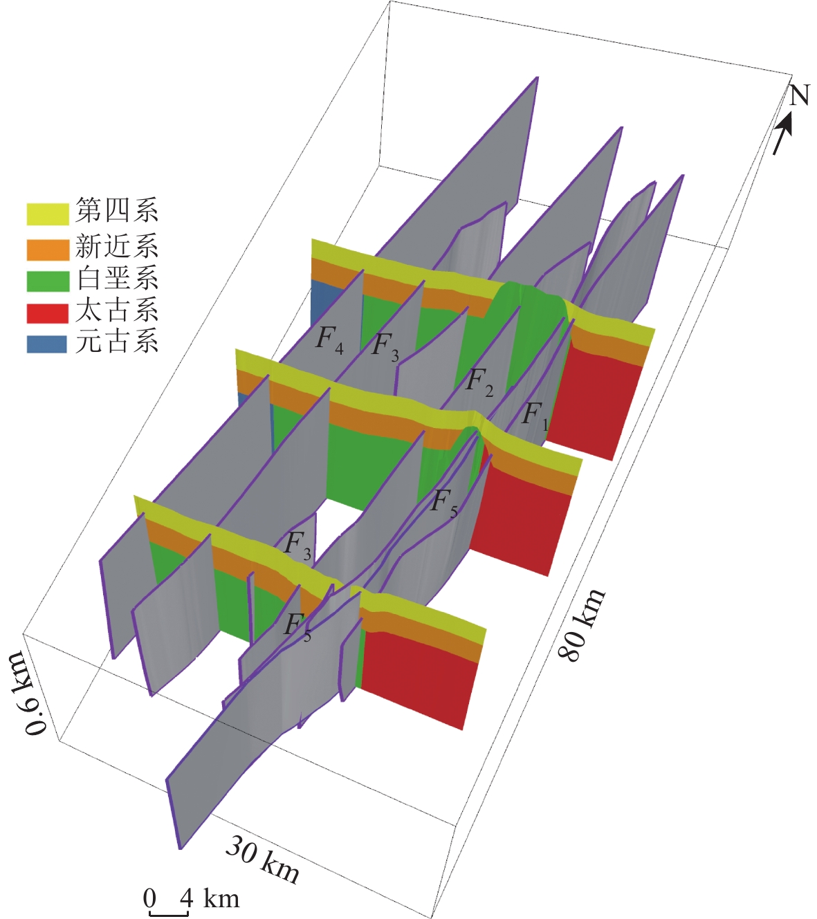
图 4 郯庐断裂带江苏段沿NE向(a)和SW向(b)的三维地质构造模型
F1:山左口—泗洪断裂;F2:新沂—新店断裂;F3:墨河—凌城断裂;F4:窑湾—高作断裂;F5:马陵山—重岗山断裂
Figure 4. 3-D geological structural models of the Jiangsu segment of the Tanlu fault zone along NE (a) and SW (b)
F1:Shanzuokou-Sihong fault;F2:Xinyi-Xindian fault;F3:Mohe-Lingcheng fault;F4:Yaowan-Gaozuo fault; F5:Malingshan-Chonggangshan fault
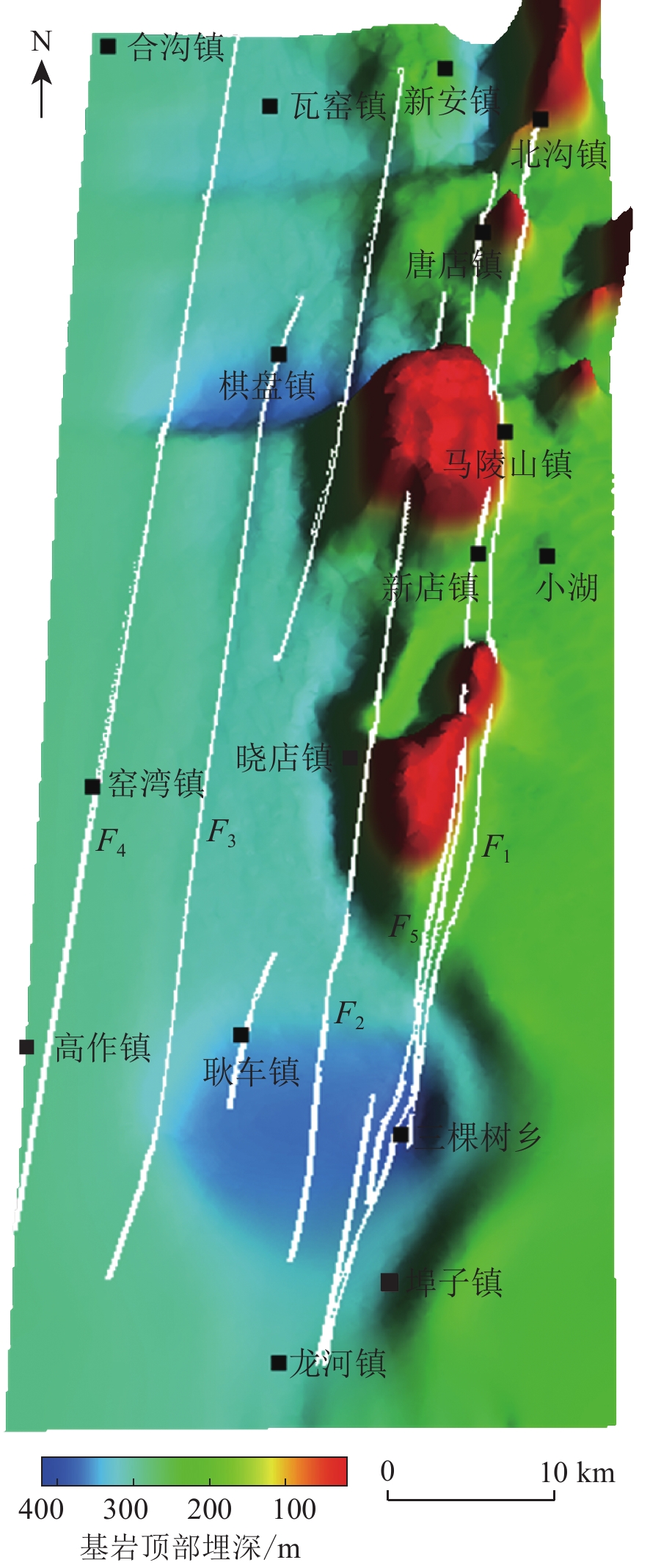
![]()
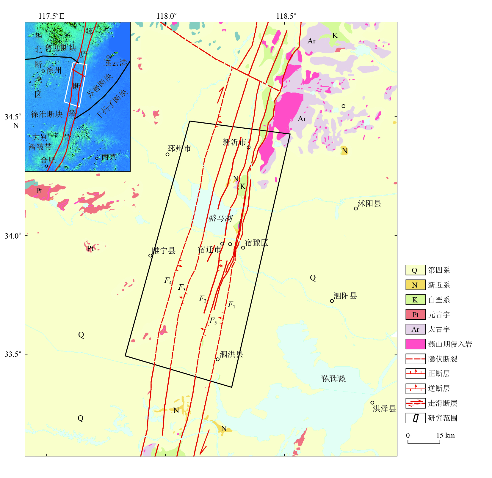
图 1 研究区地质构造简图
F1:山左口—泗洪断裂;F2:新沂—新店断裂;F3:墨河—凌城断裂;F4:窑湾—高作断裂;F5:马陵山—重岗山断裂
Figure 1. Geological tectonic settings of the studied area
F1:Shanzuokou-Sihong fault;F2:Xinyi-Xindian fault;F3:Mohe-Lingcheng fault;F4:Yaowan-Gaozuo fault; F5:Malingshan-Chonggangshan fault
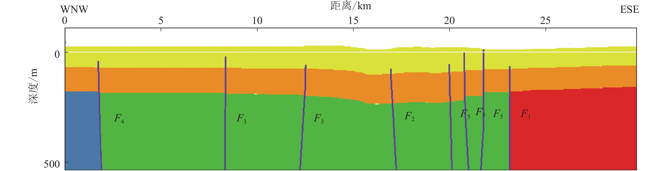
![]()
图 5 郯庐断裂带江苏段三维断裂模型
Figure 5. 3D faults model of the Jiangsu segment of Tanlu fault zone
![]()
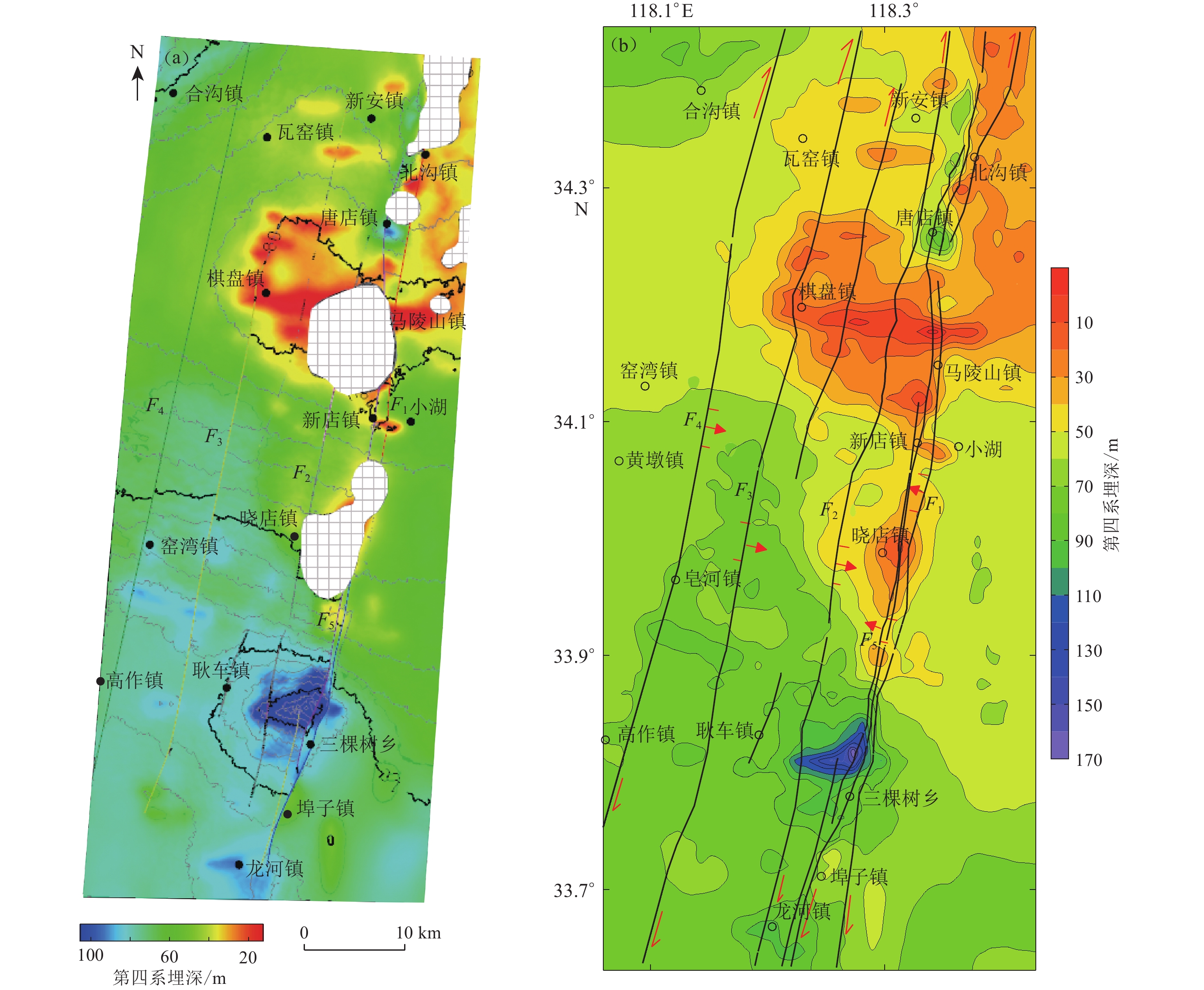
图 6 研究区第四系底界地形(a)及第四系等厚线(b)
Figure 6. Quaternary bottom boundary (a) and Quaternary isopachs (b) in the studied area
![]()
图 9 研究区新近系底界地形(a)及新近系等厚线(b)
Figure 9. Neogene bottom boundary (a) and Neogene isopachs (b) in the studied area
-
白林,林敏,彭伟航. 2018. 基于剖面的福建石门火山口三维地质建模方法[J]. 中国科技论文,13(15):1716–1721. doi: 10.3969/j.issn.2095-2783.2018.15.005 Bai L,Lin M,Peng W H. 2018. 3D geological modeling of Fujian Shimen crater based on cross sections[J]. China Science-paper,13(15):1716–1721 (in Chinese).
曹筠,冉勇康,许汉刚,李彦宝,马兴全,张鹏,李丽梅. 2018. 郯庐断裂带安丘—莒县断裂南段(郯城—淮河)晚第四纪活动特征[J]. 地震研究,41(2):280–292. doi: 10.3969/j.issn.1000-0666.2018.02.017 Cao J,Ran Y K,Xu H G,Li Y B,Ma X Q,Zhang P,Li L M. 2018. Late Quaternary activity in the southern segment of the Anqiu-Juxian fault of the Tan-Lu fault zone[J]. Journal of Seismological Research,41(2):280–292 (in Chinese).
陈超,陈广峰. 2012. 三维建模技术在区域工程地质勘查中的应用研究[J]. 城市地质,7(1):20–25. Chen C,Chen G F. 2012. Application and research of three dimensional modeling in district geologic survey[J]. City Geology,7(1):20–25 (in Chinese).
陈学习,吴立新,车德福,郝海森,徐磊. 2005. 基于钻孔数据的含断层地质体三维建模方法[J]. 煤田地质与勘探,33(5):5–8. Chen X X,Wu L X,Che D F,Hao H S,Xu L. 2005. 3D modeling method of geological bodies including faults based on borehole data[J]. Coal Geology &Exploration,33(5):5–8 (in Chinese).
程朋根,王承瑞,甘卫军,肖根如. 2005. 基于多层DEM与QTPV的混合数据模型及其在地质建模中的应用[J]. 吉林大学学报(地球科学版),35(6):806–811. Cheng P G,Wang C R,Gan W J,Xiao G R. 2005. A hybrid 3D data model based on multi-DEMs and QTPVs and its application in geological modeling[J]. Journal of Jilin University (Earth Science Edition)
,35(6):806–811 (in Chinese). 邓起东,闻学泽. 2008. 活动构造研究:历史、进展与建议[J]. 地震地质,30(1):1–30. doi: 10.3969/j.issn.0253-4967.2008.01.002 Deng Q D,Wen X Z. 2008. A review on the research of active tectonics:History,progress and suggestions[J]. Seismology and Geology,30(1):1–30 (in Chinese).
董梅,慎乃齐,胡辉,刘飞. 2008. 基于GOCAD的三维地质模型构建方法[J]. 桂林工学院学报,28(2):188–192. Dong M,Shen N Q,Hu H,Liu F. 2008. 3D geological modeling method based on GOCAD[J]. Journal of Guilin University of Technology,28(2):188–192 (in Chinese).
窦帆帆,林子瑜,叶子华. 2017. 基于GOCAD的离散点云数据三维可视化研究[J]. 四川地质学报,37(1):159–163. doi: 10.3969/j.issn.1006-0995.2017.01.036 Dou F F,Lin Z Y,Ye Z H. 2017. Study of 3D visualization of discrete data based on GOCAD[J]. Acta Geologica Sichuan,37(1):159–163 (in Chinese).
何紫兰,朱鹏飞,马恒,王文杰,白芸,曹珂. 2018. 基于多源数据融合的相山火山盆地三维地质建模[J]. 地质与勘探,54(2):404–414. He Z L,Zhu P F,Ma H,Wang W J,Bai Y,Cao K. 2018. 3D geological modeling of the Xiangshan volcanic basin based on multi-source data fusion[J]. Geology and Exploration,54(2):404–414 (in Chinese).
姬广军,朱吉祥. 2019. 三维地质建模技术研究现状[J]. 科技风,(10):109–110. Ji G J,Zhu J X. 2019. Research status of three-dimensional geological modeling technology[J]. Technology Trend,(10):109–110 (in Chinese).
贾志宾,曹凯,杨志强. 2017. 一种基于钻孔数据的优化三维地质建模方法[J]. 科学技术与工程,17(17):178–183. doi: 10.3969/j.issn.1671-1815.2017.17.025 Jia Z B,Cao K,Yang Z Q. 2017. An optimized 3D geological modeling method based on borehole data[J]. Science Technology and Engineering,17(17):178–183 (in Chinese).
李璐,刘新根,吴蔚博. 2018. 基于钻孔数据的三维地层建模关键技术[J]. 岩土力学,39(3):1056–1062. Li L,Liu X G,Wu W B. 2018. Key technology of 3D stratum modelling based on borehole data[J]. Rock and Soil Mechanics,39(3):1056–1062 (in Chinese).
梁卫卫,党海龙,张亮,高荣华,王强,刘双双. 2019. 基于平面与剖面相资料建立储层三维精细地质模型:以鄂尔多斯盆地S区块为例[J]. 非常规油气,6(2):73–78. doi: 10.3969/j.issn.2095-8471.2019.02.011 Liang W W,Dang H L,Zhang L,Gao R H,Wang Q,Liu S S. 2019. The 3D fine geological model combining plane and profile facies data:Taking S area in Ordos basin as an example[J]. Unconventional Oil &Gas,6(2):73–78 (in Chinese).
刘备,朱光,胡红雷,宋利宏. 2015. 郯庐断裂带江苏段新构造活动规律分析[J]. 地质学报,89(8):1352–1366. doi: 10.3969/j.issn.0001-5717.2015.08.002 Liu B,Zhu G,Hu H L,Song L H. 2015. Analysis on neotectonic activity of the Jiangsu part of the Tan-Lu fault zone[J]. Acta Geologica Sinica,89(8):1352–1366 (in Chinese).
鲁人齐,徐锡伟,陈立春,陈桂华,姚琪,孙建宝,任俊杰,任治坤,许冲,魏占玉,谭锡斌,董绍鹏,石峰,吴熙彦. 2018. 2017年8月8日九寨沟MS7.0地震构造与震区三维断层初始模型[J]. 地震地质,40(1):1–11. Lu R Q,Xu X W,Chen L C,Chen G H,Yao Q,Sun J B,Ren J J,Ren Z K,Xu C,Wei Z Y,Tan X B,Dong S P,Shi F,Wu X Y. 2018. Seismotectonics of the 8 August 2017 Jiuzhaigou earthquake and the three-dimensional fault models in the seismic region[J]. Seismology and Geology,40(1):1–11 (in Chinese).
潘懋,方裕,屈红刚. 2017. 三维地质建模若干基本问题探讨[J]. 地理与地理信息科学,23(3):1–5. doi: 10.3969/j.issn.1672-0504.2017.03.001 Pan M,Fang Y,Qu H G. 2017. Discussion on several foundational issues in three-dimensional geological modeling[J]. Geography and Geo-Information Science,23(3):1–5 (in Chinese).
施炜,张岳桥,董树文. 2003. 郯庐断裂带中段第四纪活动及其分段特征[J]. 地球学报,24(1):11–18. doi: 10.3321/j.issn:1006-3021.2003.01.003 Shi W,Zhang Y Q,Dong S W. 2003. Quaternary activity and segmentation behavior of the middle portion of the Tan-Lu fault zone[J]. Acta Geoscientia Sinica,24(1):11–18 (in Chinese).
孙业君, 黄耘, 江昊琳, 詹小艳, 王俊, 叶碧文, 丁烨. 2015. 郯庐断裂带鲁苏皖段构造应力场及分段特征研究[J].地震, 35(3): 66−75. Sun Y J, Huang Y, Jiang H L, Zhan X Y, Wang J, Ye B W, Ding Y. 2015. Tectonic stress field and segmention characteristics in the Shandong-Jiangsu-Anhui segment of the Tancheng-Ljiang fault zone[J]. Earthquake, 35(3): 66−75 (in Chinese).
王志才, 贾荣光, 孙昭民, 石荣会. 晁洪太. 2005. 沂沭断裂带安丘—莒县断裂安丘—朱里段几何结构与活动特征[J]. 地震地质, 27(2): 212−220. Wang Z C,Jia R G,Sun Z M,Shi R H,Chao H T. 2005. Geometry and activity of the Anqiu-Zhuli segment of the Anqiu-Juxian fault in the Yishu fault zone[J]. Seismology and Geology,27(2):212–220 (in Chinese).
吴志春,郭福生,姜勇彪,罗建群,侯曼青. 2016a. 基于地质剖面构建三维地质模型的方法研究[J]. 地质与勘探,52(2):363–375. Wu Z C,Guo F S,Jiang Y B,Luo J Q,Hou M Q. 2016a. Methods of three-dimension geological modeling based on geological sections[J]. Geology and Exploration,52(2):363–375 (in Chinese).
吴志春,郭福生,林子瑜,侯曼青,罗建群. 2016b. 三维地质建模中的多源数据融合技术与方法[J]. 吉林大学学报(地球科学版),46(6):1895–1913. Wu Z C,Guo F S,Lin Z Y,Hou M Q,Luo J Q. 2016b. Technology and method of multi-data merging in 3D geological modeling[J]. Journal of Jilin University (Earth Science Edition)
,46(6):1895–1913 (in Chinese). 许汉刚, 顾勤平, 赵启光, 范小平. 2013. 《宿迁市活动断层探测与地震危险性评价》 子课题4: 隐伏断层的控制性人工地震探测成果报告[R]. 南京: 江苏省地震工程研究院: 78–168. Xu H G, Guo Q P, Zhao Q G, Fan X P. 2013. Active Fault Detection and Seismic Risk Assessment in Suqian City, Sub-Project 4: Report on the Results of Controlled Artificial Seismic Exploration of Buried Faults[R]. Nanjing: Engineering ResearchInstitute, Jiangsu Earthquake Agency: 78–168 (in Chinese).
于贵华,徐锡伟,柴炽章,王银,刘保金. 2009. 利用活断层探测资料构建银川探测区地下三维结构模型[J]. 地震地质,29(2):320–329. Yu G H,Xu X W,Chai C Z,Wang Y,Liu B J. 2009. Constructing 3D subsurface structure model from active fault survey data of the Yinchuan area[J]. Seismology and Geology,29(2):320–329 (in Chinese).
张宝一,杨莉,陈笑扬,邓浩,毛先成. 2017. 基于图切地质剖面的区域成矿地质体三维建模与资源评价:以桂西南地区锰矿为例[J]. 吉林大学学报(地球科学版),47(3):933–948. Zhang B Y,Yang L,Chen X Y,Deng H,Mao X C. 2017. Regional metallogenic geo-bodies 3D modeling and mineral resource assessment based on geologic map cut cross-sections:A case study of manganese deposits in southwestern Guangxi,China[J]. Journal of Jilin University (Earth Science Edition)
,47(3):933–948 (in Chinese). 张鹏, 李丽梅, 张景发, 姜文亮, 陈丁, 李金良, 谭慧明. 2011. 郯庐断裂带江苏段第四纪活动特征及其动力学背景探讨[J]. 防灾减灾工程学报, 31(4): 389−396. Zhang P,Li L M,Zhang J F,Jiang W L,Chen D,Li J L,Tan H M. 2011. A discuss of the characteristics of activities in Quaternary for the Jiangsu segment of Tan-Lu fault zone and its geodynamic setting[J]. Journal of Disaster Prevention and Miti-gation Engineering,31(4):389–396 (in Chinese).
张颖慧,Ryan M,郭磊,王涛,管烨. 2018. 中加基岩地质填图与三维地质建模合作交流经验与启示[J]. 地质通报,37(2/3):314–324. Zhang Y H,Ryan M,Guo L,Wang T,Guan Y. 2018. Experience and enlightenment of cooperation in bedrock mapping and three dimensional geological modelling with Saskatchewan Geological Survey,Canada[J]. Geological Bulletin of China,37(2/3):314–324 (in Chinese).
朱光,刘国生,牛漫兰,宋传中,王道轩. 2002. 郯庐断裂带晚第三纪以来的浅部挤压活动与深部过程[J]. 地震地质,24(2):265–277. doi: 10.3969/j.issn.0253-4967.2002.02.015 Zhu G,Liu G S,Niu M L,Song C Z,Wang D X. 2002. Post-Eogene compressive activities on the Tan-Lu fault zone and their deep processes[J]. Seismology and Geology,24(2):265–277 (in Chinese).
朱良峰,吴信才,刘修国,尚建嘎. 2004. 基于钻孔数据的三维地层模型的构建[J]. 地理与地理信息科学,20(3):26–30. doi: 10.3969/j.issn.1672-0504.2004.03.006 Zhu L F,Wu X C,Liu X G,Shang J G. 2004. Reconstruction of 3D strata model based on borehole data[J]. Geography and Geo-Information Science,20(3):26–30 (in Chinese).
Calcagno P,Chilès J P,Courrioux G,Guillen A. 2008. Geological modelling from field data and geological knowledge:Part Ⅰ. Modelling method coupling 3D potential-field interpolation and geological rules[J]. Phys Earth Planet Inter,171(1/4):147–157.
Guyonnet-Benaize C,Lamarche J,Hollender F,Viseur S,Münch P,Borgomano J. 2015. Three-dimensional structural modeling of an active fault zone based on complex outcrop and subsurface data:The middle Durance fault zone inherited from polyphase Meso-Cenozoic tectonics (southeastern France)[J]. Tectonics,34(2):265–289. doi: 10.1002/2014TC003749
Jessell M. 2001. Three-dimensional geological modelling of potential-field data[J]. Comput Geosci,27(4):455–465. doi: 10.1016/S0098-3004(00)00142-4
Kaufmann O,Martin T. 2008. 3D geological modelling from boreholes,cross-sections and geological maps. Application over former natural gas storages in coal mines[J]. Comput Geosci,34(3):278–290. doi: 10.1016/j.cageo.2007.09.005
Li Y Q,Jia D,Shaw J H,Hubbard J,Lin A M,Wang M M,Luo L,Li H B,Wu L. 2010. Structural interpretation of the coseismic faults of the Wenchuan earthquake:Three-dimensional modeling of the Longmen Shan fold-and-thrust belt[J]. J Geophys Res,115(B4):B04317.
Lu R Q,Liu Y D,Xu X W,Tan X B,He D F,Yu G H,Cai M G,Wu X Y. 2019. Three-dimensional model of the lithospheric structure under the eastern Tibetan Plateau:Implications for the active tectonics and seismic hazards[J]. Tectonics,38(4):1292–1307. doi: 10.1029/2018TC005239
Mallet J L. 1989. Discrete smooth interpolation[J]. ACM Trans Graph,8(2):121–144. doi: 10.1145/62054.62057
Shaw J H,Plescha A,Tapea C. 2015. Unified structural representation of the southern California crust and upper mantle[J]. Earth Planet Sci Lett,415:1–15. doi: 10.1016/j.jpgl.2015.01.016
Wu L X. 2004. Topological relations embodied in a generalized tri-prism (GTP) model for a 3D geoscience modeling system[J]. Comput Geosci,30(4):405–418. doi: 10.1016/j.cageo.2003.06.005
 下载:
下载:

计量
- 文章访问数:
- HTML全文浏览量:
- PDF下载量:
