

Lithospheric velocity structure of Alaska revealed by double difference tomography
-
摘要: 阿拉斯加地区由不同地质时期的地体向北增生而成,经历了漫长的构造演化,地质构造复杂。ANF (Array Network Facility)网站新近提供的来自USArray地震台网记录的地震台站观测数据填补了阿拉斯加地区西部和北部的观测空白,本文选取该区域中345个台站记录的5 638个地震事件的P波、S波到时数据,采用区域双差地震层析成像方法反演得到了该地区的岩石圈三维P波速度模型和地震重定位结果。研究结果显示:阿拉斯加西部太平洋板块的俯冲倾角较大,深部地幔楔表现为P波低速异常,推测由俯冲板块顶部脱水产生的流体释放到地幔楔并触发部分熔融所致,这些熔融物质上升到达地表形成阿留申火山岛链;中部亚库塔特(Yakutat)地体与太平洋板块发生耦合,俯冲倾角减小,一方面使地壳压应力增加,引起地壳增厚和楚加奇(Chugach)山脉隆升,另一方面导致该处地幔楔降温从而使产生的熔体减少,并随着地壳压应力的增加部分地壳裂隙闭合,阻断了熔体上升至地表,从而形成迪那利(Denali)火山空区;亚库塔特地体与东部兰格尔(Wrangell)火山区之间存在较明显的分界,兰格尔火山区下方的低速区(与岩浆活动对应)集中于西北侧,火山区的岩浆来源可能与环形地幔流沿太平洋—亚库塔特板块边缘的上升流相关。这些结果表明,阿拉斯加地区深部复杂的地球动力学过程导致了其地表复杂的地质构造。Abstract: Alaska region is formed by the northward accretions of terranes from different geological periods and has experienced extensive internal deformation and metamorphism, and the geological structure is complex. The Array Network Facility (ANF) website recently provides new observational data from the seismic network of USAarray, filling the observation gap in the west and north of Alaska. Based on P and S wave arrivals of 5 638 events recorded by 345 stations from ANF, this study relocates earthquakes and images the 3D lithospheric P-wave velocity structure beneath Alaska simultaneously by regional double difference tomography. The results reveal larger dip angle of subducting Pacific Plate and low-vP anomalies in the mantle wedge beneath western Alaska. These observations reflect the subduction process, during which the dehydration of the subduting Pacific Plate releases fluids into the mantle wedge, triggers partial melting, and generates melts, which was then transported to the surface by the upwelling flow so as to form Aleutian volcanic arc. In central Alaska, the coupling between the Yakutat terrane and the Pacific Plate reduces the subduction dip. On the one hand, the shallow subduction of the Yakutat terrane increases the compressive stress of the crust, causing the crustal thickening and uplifting of Chugach mountains. On the other hand, it cools the mantle wedge reducing magma generation, which are then combined with the closure of crust fractures resulted from the increase of the crustal stress, blocking the supply of melt to the surface, and finally leading to the formation of Denali volcanic gap. In addition, there is a clear boundary between Yakutat terrane and Wrangell volcanic field in the east, and the low velocity zone corresponding to magmatic activity in the region is concentrated in the northwest. The magma source may be related to upwelling of the toroidal mantle flow around the Pacific-Yakutat slab edge. These results suggest that the complex geodynamic processes in deep Alaska lead to the complex geological structure on the surface.
-
-
![]()
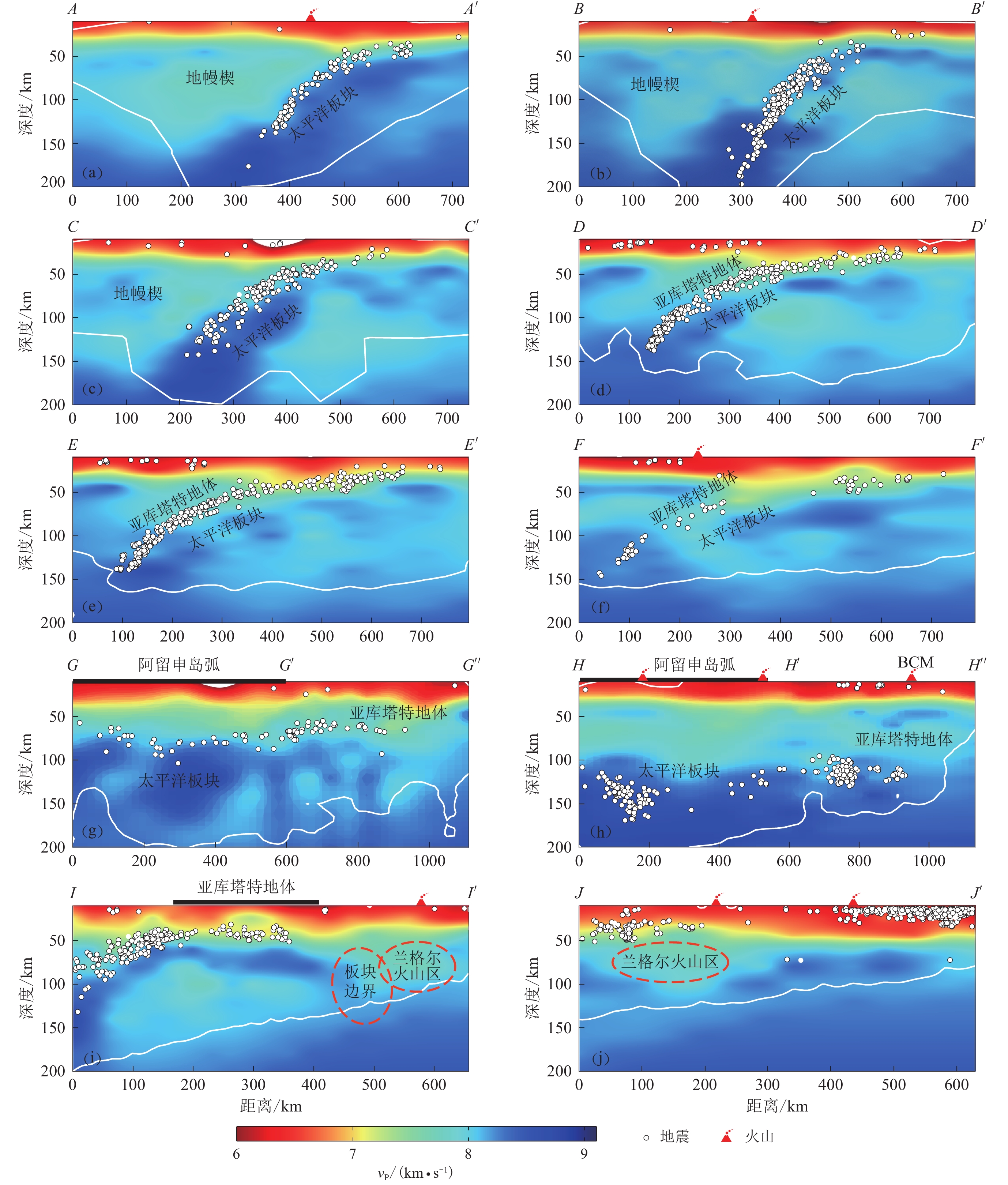
图 7 不同位置的P波速度垂直剖面图(剖面位置见图6i,白色实线以上代表DWS>1 000的区域)
Figure 7. vP models along ten cross sections at different positions (The profile location is shown in Fig. 6i,and the region above the white solid line is the region with DWS>1 000)
(a) AA′; (b) BB′; (c) CC′; (d) DD′; (e) EE′; (f) FF′; (g) GG′G′′; (h) HH′H′′; (i) II′; (j) JJ′
![]()
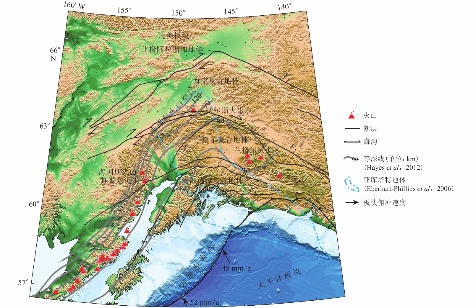
图 1 阿拉斯加构造背景图
两个箭头分别给出了太平洋板块向北美板块俯冲的速度(DeMets,Dixon,1999)和亚库塔特地体向北美板块俯冲的速度(Sauber et al,1997)。F1:廷蒂纳断层;F2:迪那利断层;F3:塔基特纳断层;F4:接触断层;F5:边界山脉断层,下同
Figure 1. Tectonic settings of Alaska
The two arrows represent subduction velocity of Pacific Plate to North America Plate (DeMets,Dixon,1999) and Yakutat Plate to North America Plate (Sauber et al,1997). F1: Tintina fault;F2:Denali fault;F3:Talkeentna fault;F4:Contact fault;F5:Border Range fault,the same below
![]()
图 3 筛选前(a)、后(b)的P波和S波时距曲线
黑线代表拟合的时距曲线,绿线代表观测与拟合的到时差为±10 s,反演中仅保留绿线以内的震相数据
Figure 3. Time-distance curves of P and S waves before (a) and after (b) selection
The black line represents the fitting time-distance curve,and the green line represents the difference of arrival time between observation and fitting is ±10 s,only the seismic phase data within the green lines are retained to ensure the data quality
![]()
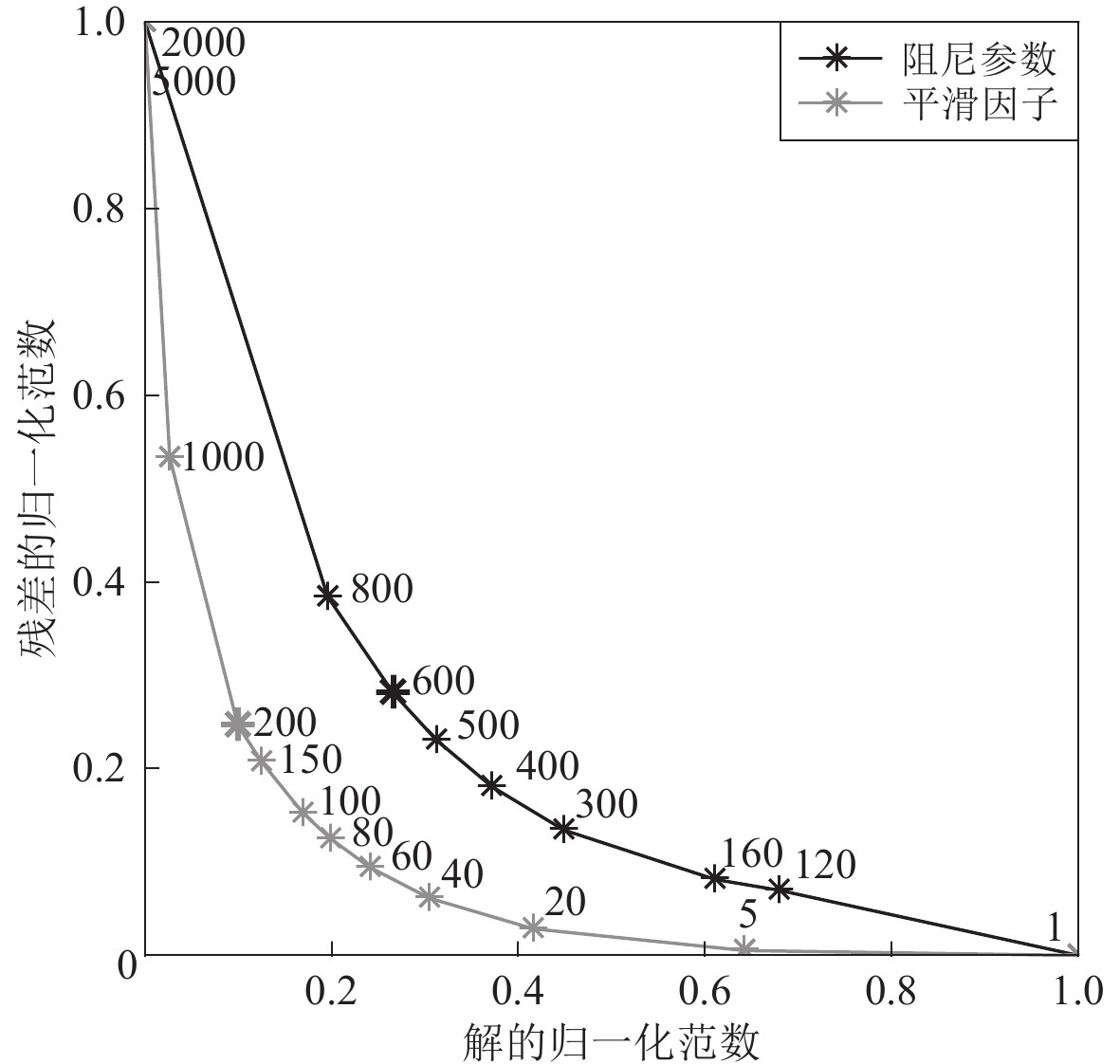
图 4 阻尼参数及平滑因子权重均衡曲线
Figure 4. Trade-off curves of damping and smoothing weight parameters
![]()
图 5 研究区不同深度水平剖面的vP棋盘测试结果(白色实线内部为DWS>1 000的区域)
Figure 5. Checkerboard test results of vP at different depths in the studied area where the white solid line delineates the area with DWS>1000
![]()
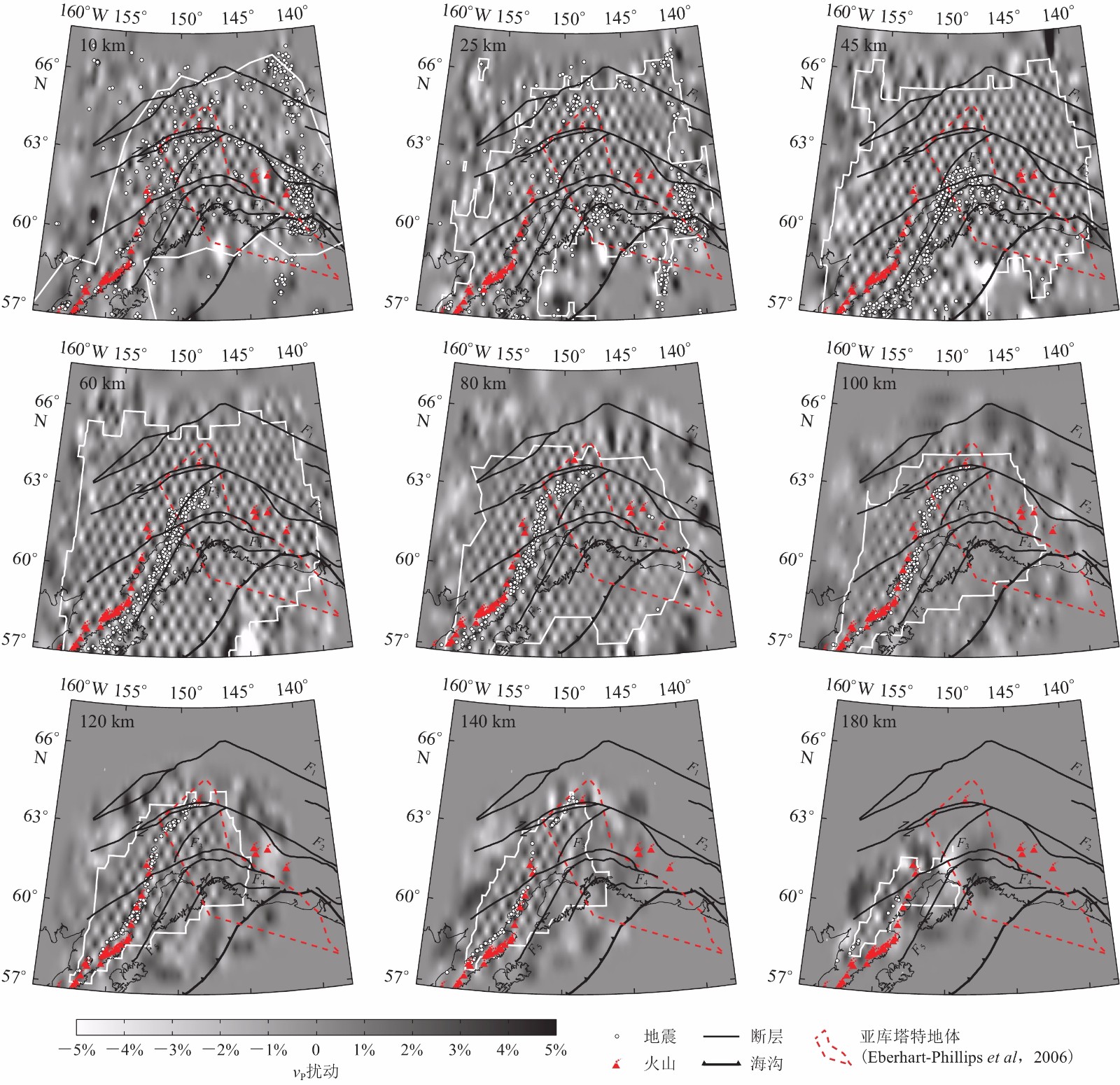
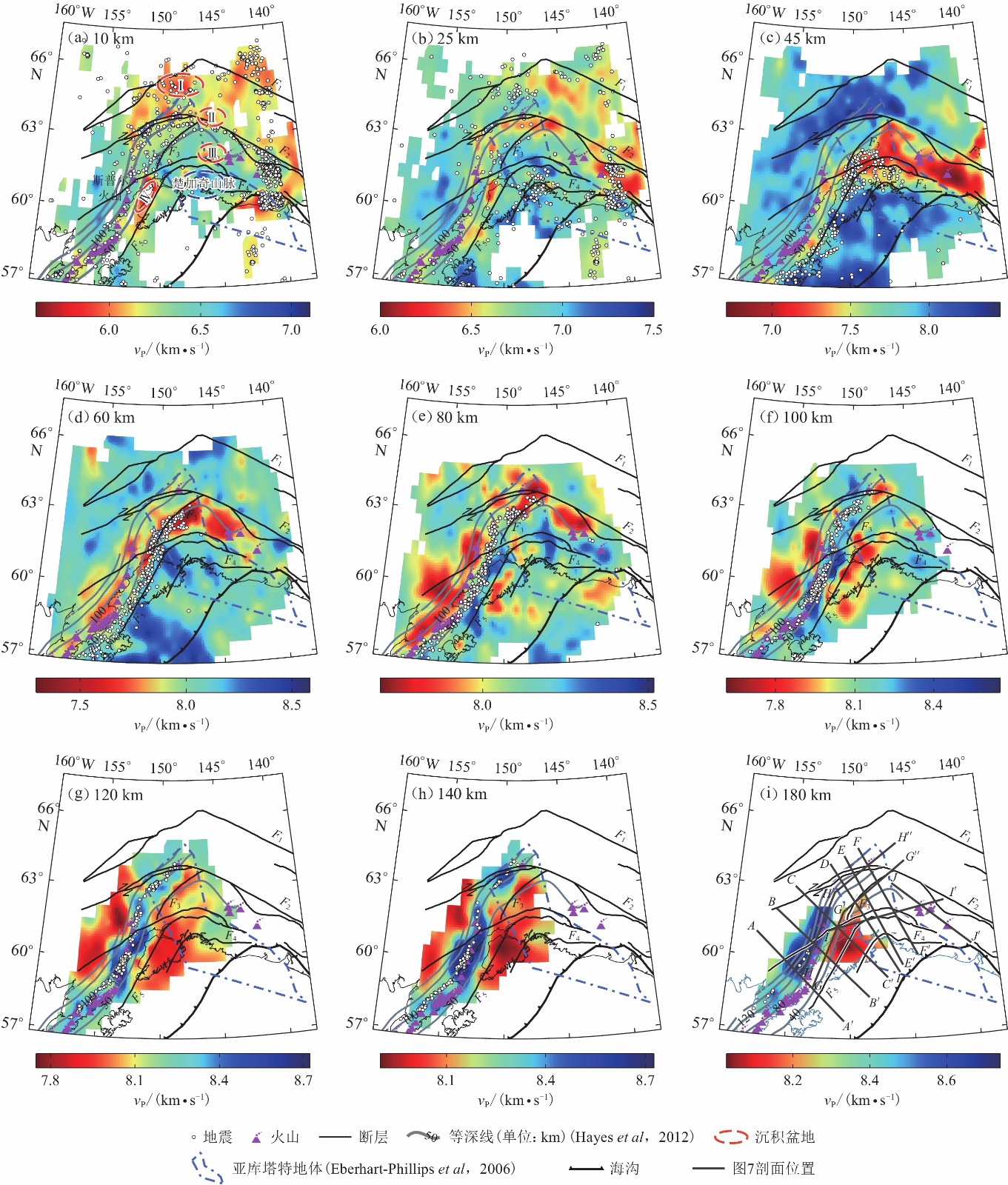
图 6 阿拉斯加地区不同深度处P波速度结构
Ⅰ . 育空盆地;Ⅱ . 塔纳纳盆地;Ⅲ . 铜河盆地;Ⅳ . 库克湾盆地
Figure 6. P-wave velocity structure in Alaska at different depths
Ⅰ . Yukon Flat basin;Ⅱ . Middle-Tanana basin;Ⅲ . Copper River basin;Ⅳ . Cook Inlet basin(a) 10 km;(b) 25 km;(c) 45 km;(d) 60 km;(e) 80 km;(f) 100 km;(g) 120 km;(h) 140 km;(i) 180 km
表 1 本文所采用的初始一维速度模型(Eberhart-Phillips et al,2006)
Table 1 Initial ID velocity model used in this study (Eberhart-Phillips et al,2006)
深度/km vP/(km·s−1) 深度/km vP/(km·s−1) 0 2.90 48.0 7.87 2.0 5.10 65.0 8.12 6.0 6.05 85.0 8.20 15.0 6.35 110.0 8.24 24.0 6.60 140.0 8.30 33.0 7.15 190.0 8.44  下载: 导出CSV
-
刘伟,吴庆举,张风雪. 2019. 利用双差层析成像方法反演青藏高原东南缘地壳速度结构[J]. 地震学报,41(2):155–168. doi: 10.11939/jass.20180083 Liu W,Wu Q J,Zhang F X. 2019. Crustal structure of southeastern Tibetan Plateau inferred from double-difference tomography[J]. Acta Seismologica Sinica,41(2):155–168 (in Chinese).
莘海亮,曾宪伟,康敏,高级. 2020. 海原弧形构造区地壳三维精细速度结构成像[J]. 地球物理学报,63(3):897–914. doi: 10.6038/cjg2020N0067 Xin H L,Zeng X W,Kang M,Gao J. 2020. Crustal fine velocity structure of the Haiyuan arcuate tectonic zone from double-difference tomography[J]. Chinese Journal of Geophysics,63(3):897–914 (in Chinese).
左可桢,陈继锋. 2018. 门源地区地壳三维体波速度结构及地震重定位研究[J]. 地球物理学报,61(7):2788–2801. doi: 10.6038/cjg2018L0537 Zuo K Z,Chen J F. 2018. 3D body-wave velocity structure of crust and relocation of earthquakes in the Menyuan area[J]. Chinese Journal of Geophysics,61(7):2788–2801 (in Chinese).
Allam A A,Schulte-Pelkum V,Ben-Zion Y,Tape C,Ruppert N,Ross Z E. 2017. Ten kilometer vertical Moho offset and shallow velocity contrast along the Denali fault zone from double-difference tomography,receiver functions,and fault zone head waves[J]. Tectonophysics,721:56–69. doi: 10.1016/j.tecto.2017.09.003
Christensen D H,Abers G A. 2010. Seismic anisotropy under central Alaska from SKS splitting observations[J]. J Geophys Res:Solid Earth,115(B4):B04315.
Christeson G L,Gulick S P S,van Avendonk H J A,Worthington L L,Reece R S,Pavlis T L. 2010. The Yakutat terrane:Dramatic change in crustal thickness across the transition fault,Alaska[J]. Geology,38(10):895–898. doi: 10.1130/G31170.1
Chuang L,Bostock M,Wech A,Plourde A. 2017. Plateau subduction,intraslab seismicity,and the Denali (Alaska) volcanic gap[J]. Geology,45(7):647–650. doi: 10.1130/G38867.1
DeMets C,Dixon T H. 1999. New kinematic models for Pacific-North America motion from 3 Ma to present,I:Evidence for steady motion and biases in the NUVEL-1A model[J]. Geophys Res Lett,26(13):1921–1924. doi: 10.1029/1999GL900405
Eberhart-Phillips D,Christensen D H,Brocher T M,Hansen R,Ruppert N A,Haeussler P J,Abers G A. 2006. Imaging the transition from Aleutian subduction to Yakutat collision in central Alaska,with local earthquakes and active source data[J]. J Geophys Res:Solid Earth,111(B11):B11303.
Enkelmann E,Zeitler P K,Pavlis T L,Garver J I,Ridgway K D. 2009. Intense localized rock uplift and erosion in the St Elias orogen of Alaska[J]. Nat Geosci,2(5):360–363. doi: 10.1038/ngeo502
Feng L L,Ritzwoller M H. 2019. A 3-D shear velocity model of the crust and uppermost mantle beneath Alaska including apparent radial anisotropy[J]. J Geophys Res:Solid Earth,124(10):10468–10497. doi: 10.1029/2019JB018122
Ferris A,Abers G A,Christensen D H,Veenstra E. 2003. High resolution image of the subducted Pacific (?) plate beneath central Alaska,50−150 km depth[J]. Earth Planet Sci Lett,214(3/4):575–588.
Gou T,Zhao D P,Huang Z C,Wang L S. 2019. Aseismic deep slab and mantle flow beneath Alaska:Insight from anisotropic tomography[J]. J Geophys Res:Solid Earth,124(2):1700–1724. doi: 10.1029/2018JB016639
Hacker B R,Peacock S M,Abers G A,Holloway S D. 2003. Subduction factory 2. Are intermediate-depth earthquakes in subducting slabs linked to metamorphic dehydration reactions?[J]. J Geophys Res:Solid Earth,108(B1):2030.
Hansen P C,O’Leary D P. 1993. The use of the L-curve in the regularization of discrete ill-posed problems[J]. SIAM J Sci Comput,14(6):1487–1503. doi: 10.1137/0914086
Hayes G P,Wald D J,Johnson R L. 2012. Slab1.0:A three-dimensional model of global subduction zone geometries[J]. J Geophys Res:Solid Earth,117(B1):B01302.
Jadamec M A,Billen M I. 2010. Reconciling surface plate motions with rapid three-dimensional mantle flow around a slab edge[J]. Nature,465(7296):338–341. doi: 10.1038/nature09053
Jadamec M A,Billen M I. 2012. The role of rheology and slab shape on rapid mantle flow:Three-dimensional numerical models of the Alaska slab edge[J]. J Geophys Res:Solid Earth,117(B2):B02304.
Jadamec M A,Billen M I,Roeske S M. 2013. Three-dimensional numerical models of flat slab subduction and the Denali fault driving deformation in south-central Alaska[J]. Earth Planet Sci Lett,376:29–42. doi: 10.1016/j.jpgl.2013.06.009
Jiang C X,Schmandt B,Ward K M,Lin F C,Worthington L L. 2018. Upper mantle seismic structure of Alaska from Rayleigh and S wave tomography[J]. Geophys Res Lett,45(19):10350–10359.
Kissling E,Lahr J C. 1991. Tomographic image of the Pacific slab under southern Alaska[J]. Eclogae Geol Helv,84(2):297–315.
Martin-Short R,Allen R,Bastow I D,Porritt R W,Miller M S. 2018. Seismic imaging of the Alaska subduction zone:Implications for slab geometry and volcanism[J]. Geochem Geophys Geosyst,19(11):4541–4560. doi: 10.1029/2018GC007962
McNamara D E,Pasyanos M E. 2002. Seismological evidence for a sub-volcanic arc mantle wedge beneath the Denali volcanic gap,Alaska[J]. Geophys Res Lett,29(16):1814.
Miller M S,Moresi L. 2018. Mapping the Alaskan Moho[J]. Seismol Res Lett,89(6):2430–2436. doi: 10.1785/0220180222
Page R A, Stephens C D, Lahr J C.1989. Seismicity of the Wrangell and Aleutian Wadati-Benioff zones and the North American Plate along the Trans-Alaska crustal transect, Chugach mountains and Copper River basin, southern Alaska[J]. J Geophys Res: Solid Earth, 94(B11): 16059-16082.
Qi C,Zhao D P,Chen Y. 2007. Search for deep slab segments under Alaska[J]. Phys Earth Planet Inter,165(1/2):68–82.
Richter D H,Smith J G,Lanphere M A,Dalrymple G B,Reed B L,Shew N. 1990. Age and progression of volcanism,Wrangell volcanic field,Alaska[J]. Bull Volcanol,53(1):29–44. doi: 10.1007/BF00680318
Rondenay S,Montési L G J,Abers G A. 2010. New geophysical insight into the origin of the Denali volcanic gap[J]. Geophys J Int,182(2):613–630. doi: 10.1111/j.1365-246X.2010.04659.x
Sauber J,McClusky S,King R. 1997. Relation of ongoing deformation rates to the subduction zone process in southern Alaska[J]. Geophys Res Lett,24(22):2853–2856. doi: 10.1029/97GL52979
Schultz R A,Aydin A. 1990. Formation of interior basins associated with curved faults in Alaska[J]. Tectonics,9(6):1387–1407. doi: 10.1029/TC009i006p01387
Thurber C,Eberhart-Phillips D. 1999. Local earthquake tomography with flexible gridding[J]. Comput Geosci,25(7):809–818. doi: 10.1016/S0098-3004(99)00007-2
Thurber C H,Brocher T M,Zhang H J,Langenheim V E. 2007. Three-dimensional P wave velocity model for the San Francisco Bay region,California[J]. J Geophys Res:Solid Earth,112(B7):B07313.
van Stiphout T,Kissling E,Wiemer S,Ruppert N. 2009. Magmatic processes in the Alaska subduction zone by combined 3-D b value imaging and targeted seismic tomography[J]. J Geophys Res:Solid Earth,114(B11):B11302.
Venereau C M A,Martin-Short R,Bastow I D,Allen R M,Kounoudis R. 2019. The role of variable slab dip in driving mantle flow at the eastern edge of the Alaskan subduction margin:Insights from shear-wave splitting[J]. Geochem Geophys Geosyst,20(5):2433–2448.
Waldhauser F,Ellsworth W L. 2000. A double-difference earthquake location algorithm:Method and application to the northern Hayward fault,California[J]. Bull Seismol Soc Am,90(6):1353–1368. doi: 10.1785/0120000006
Wang Y,Tape C. 2014. Seismic velocity structure and anisotropy of the Alaska subduction zone based on surface wave tomography[J]. J Geophys Res:Solid Earth,119(12):8845–8865. doi: 10.1002/2014JB011438
Ward K M. 2015. Ambient noise tomography across the southern Alaskan Cordillera[J]. Geophys Res Lett,42(9):3218–3227. doi: 10.1002/2015GL063613
Ward K M,Lin F C. 2018. Lithospheric structure across the Alaskan Cordillera from the joint inversion of surface waves and receiver functions[J]. J Geophys Res:Solid Earth,123(10):8780–8797. doi: 10.1029/2018JB015967
Xin H L,Zhang H J,Kang M,He R Z,Gao L,Gao J. 2019. High-resolution lithospheric velocity structure of continental China by double-difference seismic travel-time tomography[J]. Seismol Res Lett,90(1):229–241. doi: 10.1785/0220180209
You T,Zhao D P. 2012. Seismic anisotropy and heterogeneity in the Alaska subduction zone[J]. Geophys J Int,190(1):629–649. doi: 10.1111/j.1365-246X.2012.05512.x
Zhang H,Thurber C H. 2007. Estimating the model resolution matrix for large seismic tomography problems based on Lanczos bidiagonalization with partial reorthogonalization[J]. Geophys J Int,170(1):337–345. doi: 10.1111/j.1365-246X.2007.03418.x
Zhang H J,Thurber C H. 2003. Double-difference tomography:The method and its application to the Hayward fault,California[J]. Bull Seismol Soc Am,93(5):1875–1889. doi: 10.1785/0120020190
Zhang Y,Li A B,Hu H. 2019. Crustal structure in Alaska from receiver function analysis[J]. Geophys Res Lett,46(3):1284–1292. doi: 10.1029/2018GL081011
Zhao D P,Christensen D,Pulpan H. 1995. Tomographic imaging of the Alaska subduction zone[J]. J Geophys Res:Solid Earth,100(B4):6487–6504. doi: 10.1029/95JB00046

计量
- 文章访问数: 746
- HTML全文浏览量: 198
- PDF下载量: 112
