

Statistical characteristics of enhanced seismicity before strong earthquakes based on earthquake cases in Chinese mainland
-
摘要:
依据 《中国震例》 (1966—2017年)对1966年以来中国大陆东部MS>6.0、西部MS>7.0强震前地震活动增强的异常现象特征进行了系统的梳理,并试图总结不同活动构造地块周缘强震前地震活动增强的异常时空演化特征。结果显示:① 我国大陆大震前普遍存在地震活动增强现象,33个震例中有21个震例存在震前地震活动增强异常,占比达64%;② 西部地区大多数震例的地震活动增强空间范围表现为中间尺度或构造尺度,且主震震级越大,越有可能出现大范围的地震活动增强;③ 西部地区出现中强地震活动增强的概率高于东部地区,前兆地震活动增强的平均震级较大,发生大震(M>7.0)的概率增大;④ 西部地区地震活动增强的时间尺度与震级成正比,而东部地区随着震级增大,更可能出现中期到中短期的地震活动增强异常;⑤ 多数西部地区震例在震前出现不同时间尺度的地震活动增强叠加的现象;⑥ 川滇菱形地块的强震前均出现了中长期尺度的地震条带交会现象、不同空间尺度的地震空区以及中短期尺度的中小震活动增强现象,并且对大震地点有较好的指示意义。巴颜喀拉东边界与北、西及南边界大震前存在显著的不同地震活动增强特征,震前未出现中强地震围空的现象。
Abstract:Before strong earthquakes, enhanced seismicity manifested by increased magnitude, frequency, or accelerated strain release generally appears within a specific temporal and spatial range of the source area. This significant enhanced seismicity is often observed before moderate-strong earthquakes occurred in Chinese mainland or abroad. The seismogenic processes of large earthquakes are multiscale and diverse, involving localization of deformation, fault heterogeneities, and variable local loading rate effects. Enhanced seismicity prior to moderate-strong earthquakes is closely related to such processes and exhibits different characteristics. An in-depth study of enhanced seismicity will help us to understand the seismogenic process of strong-large shocks, which may bring positive effect on predicting strong shocks based on them.
Many studies have been performed to analyze the characteristics of enhanced seismicity. A more thoughtful and systematic study is needed due to rapidly increased strong earthquake data in Chinese mainland and the urgent requirement for statistical predictive indicators. In this study, we intend to summarize the statistical characteristics of the prominent enhanced seismicities before moderate-strong earthquakes and attempt to seek the proper mechanism. Based on Earthquake Cases in China (1966−2017), the spatio-temporal characteristics of the seismicity before strong earthquakes with magnitude MS≥6.0 in the eastern Chinese mainland and MS≥7.0 in the western Chinese mainland are summarized statistically. In the meantime, the regional features of enhanced seismicity before the strong earthquakes within the SichuanYunnan rhombic block, Bayan Har block, and North China block are also studied. The main contents and conclusions are as follows:
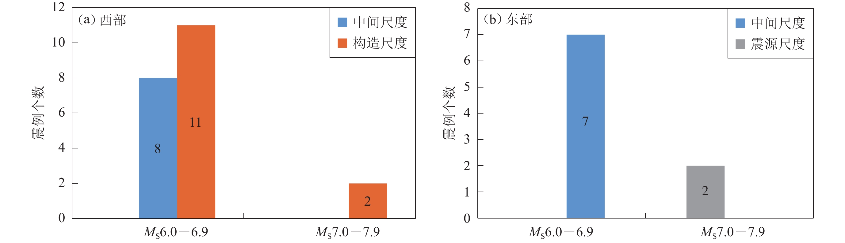
Among the 33 earthquake cases studied in this paper, 21 showed enhanced seismicity before the main shock, accounting for 64%, including five earthquakes of MS6.0−6.9, 14 earthquakes of MS7.0−7.9, and two earthquakes of MS8.0 or above. The percentage of enhanced seismicity is 42% for sub-grade class from MS6.0 to MS6.9, 74% for for sub-grade class from MS7.0 to MS7.9 and 100% for sub-grade class from MS8.0 or above. The possibility of the occurrence of enhanced seismic activity will increase with the magnitude of the main shock. The enhancement of seismicity appeared in 13 out of 18 cases in western Chinese mainland, accounting for 72%; 8 out of 15 cases in eastern Chinese mainland, accounts for 53%.
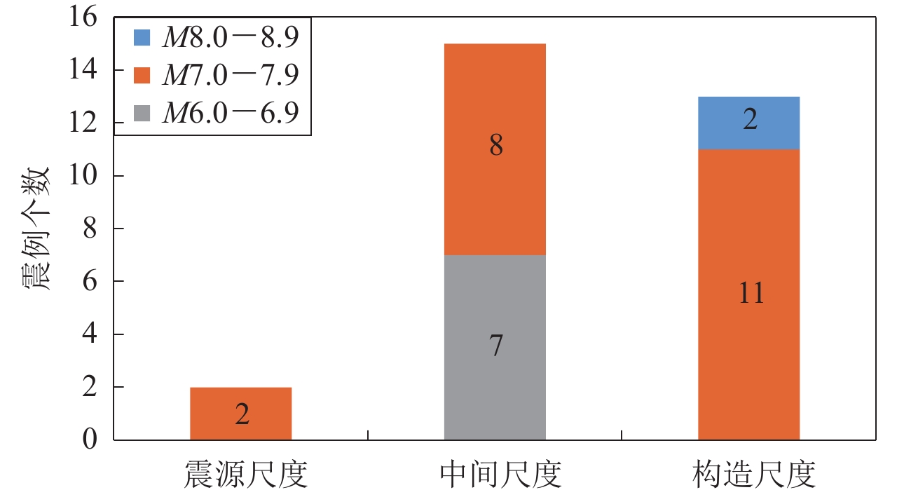
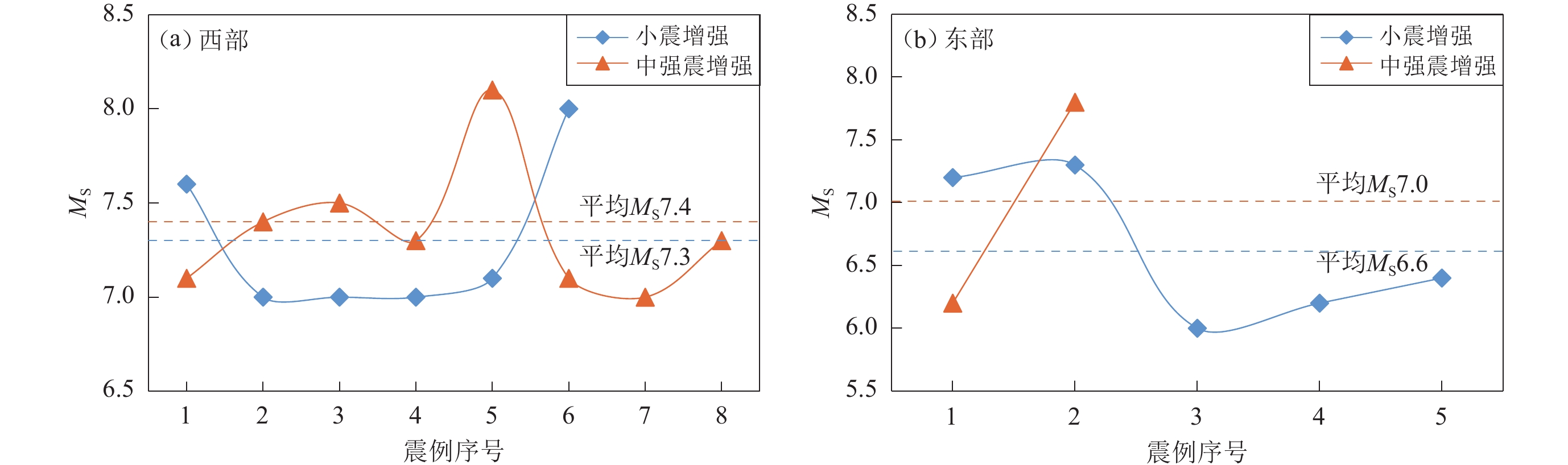
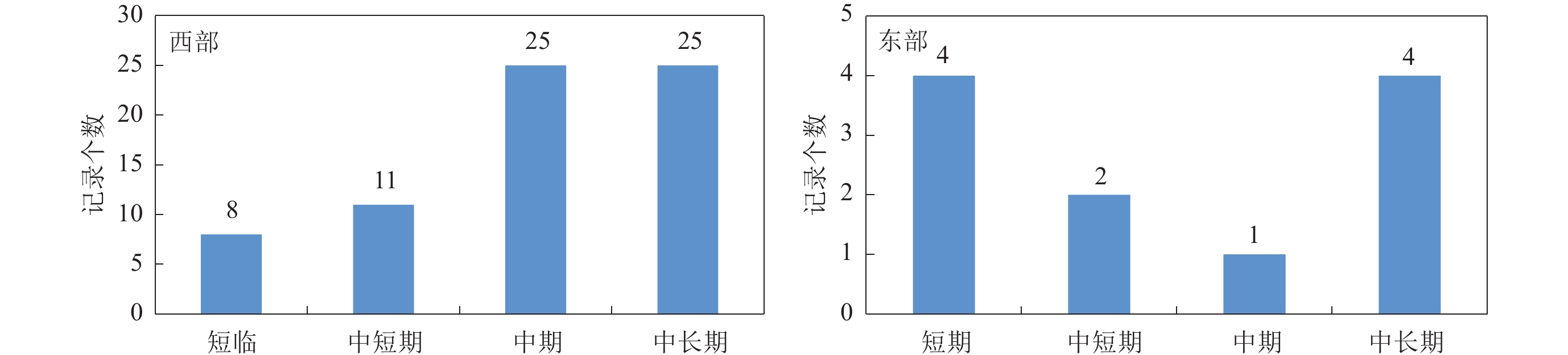
Secondly, in most cases for western Chinese mainland, the spatial extent of enhanced seismicities was observed within the intermediate or tectonic scale, and the probability of enhanced seismicity with a significant spatial scale increases with the magnitude of the main shock. Furthermore, the likelihood of enhanced seismicity with a large magnitude in western Chinese mainland is higher than in eastern Chinese mainland. The larger the average magnitude of enhanced premonitory seismicity, the more likely strong earthquakes with MS>7.0 occur. The duration of seismic activity enhancement in the western Chinese mainland is directly proportional to magnitude of the main shock, while in the eastern Chinese mainland, the relatively more significant events tend to be associated with a mid-short-term enhanced seismicity.
Thirdly, the strong earthquakes in Sichuan-Yunnan rhombic block were preceded by the medium-long term intersected seismic strips, the various spatial-scale seismic gaps, and the enhancement of small-moderate earthquakes at medium-short-term scales. These features significantly indicate the location of further quakes, which deserves more attention. Different from the eastern border of the Bayan Har block, at the other three boundaries of the Bayan Har block, strong earthquakes are often attacked with seismic gaps encircled by premonitory medium-strong earthquakes. The seismic gap generally arises in medium-long-term time scales, and the mid-short-term scale enhanced seismicity is notable before strong earthquakes in the northern margin of North China block. In particular, the magnitude of the Haicheng earthquake is comparable to that of the Tangshan earthquake. Still, the Haicheng earthquake was not preceded by a significant and long seismicity enhancement, which suggests that the secondary blocks or adjacent tectonic influences may also control the enhancement of seismicity before earthquake.
Fourthly, enhanced seismicity prior to large earthquakes drives damage to the surrounding rocks. These enhanced seismicities are not limited to the faults that generate large earthquakes. Still, they drive distributed rupture and local rock mass deformation, ultimately resulting in major slip zones and large earthquakes. Laboratory studies of rocks and similar samples have shown that a relatively long period of distributed deformation precedes the onset of large ruptures. The enhanced seismicity manifested in foreshocks is the most significant signal for the subsequent occurrence of a larger seismic event at a similar time and space. However, the enhanced seismicity does not appear as a foreshock in every case related to the seismogenic mechanism. The cascade-up framework and pre-slip model are generally used to account for the occurrence of a foreshock, whereas the progressive localization framework is suitable for explaining the enhancement of seismicity without significant foreshocks.
-
引言
印度板块和欧亚板块的碰撞使得欧亚大陆中部产生剧烈变形,从而导致形成于古生代末的天山褶皱带在晚新生代以后再次强烈隆升成再生造山带(Allen et al,1993;邓起东等,2000)。由于青藏高原西构造结节向北推挤和塔里木地块顺时针旋转导致了西天山和哈萨克斯坦地块内部发育一组NW向右旋走滑断层(图1)。塔拉斯—费尔干纳断裂是中亚地区的巨型右旋走滑断裂带,始于哈萨克斯坦境内,终至中国喀什以北,全长约为1 000 km,累计位移达200 km (Burtman et al,1996),研究表明该断裂上距今5 000年内发生了三次古地震事件,全新世以来右旋滑动走滑速率为13—14 mm/a (Korjenkov et al,2010),现今GPS观察到的右旋滑动速率为1—4 mm/a (杨少敏等,2008; Zubovich et al,2010)。而博罗可努—阿齐克库都克断裂(以下简称博阿断裂)作为中天山与北天山地块的分界断裂,起始于巴尔喀什湖东侧,经阿拉湖南缘、阿拉山口、艾比湖到达吐鲁番盆地南缘,止于鄯善以南的觉罗塔格山山体内,是一条发育在古缝合带上的活动断裂,全长超过1 000 km,走向NW (邓起东等,2000),对于博阿断裂的滑动速率测算得出了不同的结果。杨晓平和沈军(2000)得到的精河县东南段晚更新世以来的走滑速率约为5 mm/a;Shen 等(2011)根据下切河流阶地的形成年龄与河流位错的关系,认为博阿断裂自西向东其走滑速率逐渐减小,阿拉山口附近晚更新世以来的走滑速率约为5 mm/a,吐鲁番盆地西缘晚更新世以来的走滑速率仅约为1.4 mm/a;Campbell 等(2013)得到晚第四纪以来在阿拉山口以北哈萨克斯坦境内的博阿断裂的右旋走滑速率约为2.2 mm/a;基于GPS数据估算的博阿断裂的右旋走滑速率为1.7—2.4 mm/a (李杰等,2010),对冲沟位错及洪积扇年代学的研究表明,博阿断裂精河段的活动速率为(3.1±0.3) mm/a (胡宗凯等,2019)。尽管前人对该断裂已进行了较深入的研究,但主要集中在断裂展布和活动性方面,对古地震和最新活动时代均未深入分析;且该区域内所有NW向断裂规模宏大,但尚未发生过M≥7.5地震,最大发震能力值得商榷。前人关于形变带长度和单次位错研究认为,博阿断裂的阿拉山口—精河东南段为一整体,具有发生M7.5—7.8地震危险性(杨晓平,沈军,2000;Shen et al, 2011),但并未对断裂活动性分段予以分析,此外,1765年精河M61/2地震导致古城墙坍塌,房屋倒塌,但其发震构造尚待确定。
![]() 图 1 青藏高原西构造结节和天山地区的构造及强震分布图F1: 塔拉斯—费尔干纳断裂; F2: 肯迪克塔什断裂; F3: 博罗可努-阿齐克库都克断裂;F4:温泉—博乐断裂;F5:四棵树—古尔图南断裂Figure 1. Structure of western Syntaxis of Tibet Plateau and Tianshan area and distribution of earthquakesF1:Talas-Fergana fault; F2:Kindyktash fault; F3:Bolokenu-Aqikekuduk fault; F4:Wenquan-Bole fault;F5:Sikeshu-Guertunan fault
图 1 青藏高原西构造结节和天山地区的构造及强震分布图F1: 塔拉斯—费尔干纳断裂; F2: 肯迪克塔什断裂; F3: 博罗可努-阿齐克库都克断裂;F4:温泉—博乐断裂;F5:四棵树—古尔图南断裂Figure 1. Structure of western Syntaxis of Tibet Plateau and Tianshan area and distribution of earthquakesF1:Talas-Fergana fault; F2:Kindyktash fault; F3:Bolokenu-Aqikekuduk fault; F4:Wenquan-Bole fault;F5:Sikeshu-Guertunan fault针对以上问题,本文在高分遥感解译的基础上,对断裂沿线进行地质考察,针对重点区段进行无人机航测,获取断裂位错量信息。并选择在地貌和沉积典型位置开挖探槽,对第四纪沉积层和堆积楔进行分析,之后结合新年代学测试结果,讨论断裂不同段落的古地震期次,厘定各段最新活动时间,并根据离逝时间探讨断裂各段地震危险性,为断裂各段地震危险性判定提供可靠地质依据。
1. 博阿断裂天山以北段展布解译及活动分段
天山以北博阿断裂主要沿NW−NNW方向展布,遥感解译其总长度约为370 km,其中巴尔喀什湖东缘—阿拉湖南总长约为250 km,以断裂走向和活动性质为依据将其划分为三段:阿拉湖以北段(长约100 km),活动地貌表现不明显,地貌宏观线性较好,迹线较平直,推测其为右旋走滑性质,未见近期活动变形带;阿拉湖段,长度约为100 km,以正断为主,变形带非常清晰,以陡坎地貌发育为主,未见明显的走滑活动性质,该段为阿拉湖盆地南缘控制断裂,严格控制了洪积扇与山体的分界,总体走向为285°,断裂沿山体边缘展布,局部段落呈弧形展布;阿拉山口—巴音阿门段,长度约为160 km,自阿拉湖东侧开始,断裂走向发生转变,由西侧走向315°进一步向NW偏转25°,总体走向为340°,以右旋走滑运动为主,兼具正断及逆冲分量。本文野外研究重点区域为中国境内的精河段,该段长约120 km (图2)。以精河县城为界,由于其它断裂截切,将该段分为艾比湖段(阿拉山口—精河县)和精河以东段(精河县—巴音阿门)两段(图1,2)。
![]() 图 2 博阿断裂天山以北段的展布影像解译及活动性质(a) 博阿断裂总体展布图;(b) 艾比湖西岸断裂影像;(c) 100棵树附近断裂影像;(d) 精河县城断裂影像。图中黄色框为艾比湖段;蓝色框为精河以东段;红色剪头指示形变带。影像来自Google EarthFigure 2. The distribution and activity of the northern Tianshan mountain segment of Bolokenu-Aqikekuduk fault(a) The trace of Bolokenu−Aqikekuduk fault;(b) The trace of Aibi lake segment;(c) The trace of 100 trees segment;(d) The trace of Jinghe county. The yellow frame is Aibi lake segment,blue frame is east Jinghe segment,red arrows indicate deformation trace of the fault. The figures are from Google Earth
图 2 博阿断裂天山以北段的展布影像解译及活动性质(a) 博阿断裂总体展布图;(b) 艾比湖西岸断裂影像;(c) 100棵树附近断裂影像;(d) 精河县城断裂影像。图中黄色框为艾比湖段;蓝色框为精河以东段;红色剪头指示形变带。影像来自Google EarthFigure 2. The distribution and activity of the northern Tianshan mountain segment of Bolokenu-Aqikekuduk fault(a) The trace of Bolokenu−Aqikekuduk fault;(b) The trace of Aibi lake segment;(c) The trace of 100 trees segment;(d) The trace of Jinghe county. The yellow frame is Aibi lake segment,blue frame is east Jinghe segment,red arrows indicate deformation trace of the fault. The figures are from Google Earth2. 断裂活动性及古地震研究
2.1 艾比湖段探槽及地貌
博阿断裂艾比湖段始于阿拉山口市西侧山麓戈壁滩,由于断裂北东盘上升,南侧山体所降雨水未能继续北流进入低洼河谷,而是沿断裂自艾比湖南侧注入该断裂控制的大冲沟,断裂在湖相阶地上呈线性展布,最新活动迹象最为明显,也是本文研究的重点区段(图2a,b)。随后断裂延入艾比湖,湖内长度约为30 km,并在湖东侧的河湖三角冲积漫滩出露,延伸至精河县城西北,由于耕地改造等原因,行迹不清。而精河县城北部的达流村可见断裂控制耕地边界,呈断续线性展布,断裂南侧为耕地,而北侧则土壤沙砾化严重,几无植被发育(图2d),断裂在此处对植被控制的现象与艾比湖西侧几乎一致,因此推测其活动性质具有同样的正断性质。艾比湖段总长度约为60 km。
在艾比湖西岸湖相阶地上发育线性断裂地貌,其严格的控制了该区域的植被发育,由于断裂北侧抬升,山前冲沟的水补充减少,所以其植被较少;而断裂南侧由于地下水相对丰沛,因此,沙漠植物梭梭草生长较为密集,也相对高大。该段形变带长约2 km,走向为340° (图2b,3)。艾比湖由于晚更新世以来水位剧烈退缩,发育有多级古湖岸线,其原始形态为一天然坝体,宽数米,由于湖水波浪的冲击作用,坝体顶面一般高出其对应湖面2—3 m,坝体后缘发育小型水体,也叫障壁塘。博阿断裂(红色剪头之间)在Ⅱ级湖岸线或阶地面以上线性明显,表现为正断陡坎,陡坎高约1 m,Ⅱ级湖岸线高出湖面约18 m,宽约200 m,前人研究其形成年代距今4.5—6 ka (吴敬禄,1995),表明其形成于全新世,但由于断裂南侧阶地被冲沟所破坏,位错标志不能获得,因此只能判定该断裂为全新世活动断裂,尚未获得其右旋位错距离(图3)。
![]() 图 3 艾比湖西北岸断裂无人机航测合成影像(a)和高程图(b)(图中红色箭头指向断层滑动面)Figure 3. Unmanned aerial vehicle aerial composite image (a) and digital elevation model in the northwest bank of Aibi lake (b)where red arrows indicate fault scarp trace
图 3 艾比湖西北岸断裂无人机航测合成影像(a)和高程图(b)(图中红色箭头指向断层滑动面)Figure 3. Unmanned aerial vehicle aerial composite image (a) and digital elevation model in the northwest bank of Aibi lake (b)where red arrows indicate fault scarp trace在Ⅱ与Ⅲ级湖岸线之间,垂直线性陡坎处开挖探槽,探槽长为20 m,最大深度为3.5 m (图3,4),当挖至陡坎南侧时,冲沟一侧便有水涌出,探槽南端开始坍塌,无法继续开挖,断裂发育在陡坎中部位置,由于张性滑动和充填作用,断裂面两侧多充填细沙,其中砾石均发生沿滑动面的定向排列,形成厚约为20 cm的断层破碎带,局部发育多个次级滑动面(图4c)。由于细砂的渗透系数为0.001—0.005 cm/s,而砂砾石为0.01—0.1 cm/s,渗透系数相差20倍以上(毛昶熙,2009),因此,细砂层具有明显的阻隔作用,而地下潜水多沿渗透系数小的冲沟一侧流走,水量极少渗透到断裂北侧,加之断裂北侧抬升,与南侧存在明显高差,导致其潜水层埋深过大,地上植被很难生存,从而致使上述断裂位置和植物线性重合的地貌现象产生。
![]() 图 4 探槽东壁局部照片图中红色箭头指向断层迹线,E1和E2为地震崩积楔体Figure 4. Splicing photos of east wall of the trenchThe red arrows indicate fault slip face,E1 and E2 are earthquake colluvial wedge
图 4 探槽东壁局部照片图中红色箭头指向断层迹线,E1和E2为地震崩积楔体Figure 4. Splicing photos of east wall of the trenchThe red arrows indicate fault slip face,E1 and E2 are earthquake colluvial wedge探槽东西壁均揭露多套地层,但断裂两盘地层可对比性差,其中两盘最顶部均有棕黑色砾石土层发育。上盘厚约60 cm,探槽西壁该土层底部存在砾石定向排列现象,并发育纵向裂缝;下盘厚度小于30 cm,层理不发育,根系发育,底部弱钙质胶结;而探槽东壁该砾石土层无明显错动现象,发育崩积楔E1,断裂错动面上达地表附近。仅下盘发育的土层为: 黑色砾石粗砂层,厚度约为60 cm,水平层理发育; 黑褐色砂砾石层,水平层理发育,偶夹薄砂透镜体;黄褐色砾石粗砂层,水平层理发育,可见厚度大于2 m,未见底。仅上盘发育的土层有:灰黄色细砾粗砂层,层理发育,钙质胶结,断裂一侧明显错动,裂缝发育;褐色钙质胶结砾石夹砂层,近断裂一侧发生明显错动,与上层共同形成三角形楔体E2,该崩积楔由砂砾石组成,砾石定向和裂缝发育,推测在楔体形成之后,后期地震活动,在断层面错动摩擦牵引作用下,楔体内发生不均匀轻微错动形成(图5,6)。
![]() 图 5 探槽西壁拼合照片及局部断裂细节图(a) 探槽西壁拼合;(b) 探槽西壁采样分布;(c) 断层带细节。红色剪头指示断层面Figure 5. Splicing photos of west wall of the trench and details of faults section(a) Splicing photos of west wall of the trench;(b) The aging sample sites;(c) The details of the fault section. Red arrows indicate fault slip face
图 5 探槽西壁拼合照片及局部断裂细节图(a) 探槽西壁拼合;(b) 探槽西壁采样分布;(c) 断层带细节。红色剪头指示断层面Figure 5. Splicing photos of west wall of the trench and details of faults section(a) Splicing photos of west wall of the trench;(b) The aging sample sites;(c) The details of the fault section. Red arrows indicate fault slip face![]() 图 6 探槽西壁剖面素描图及样品位置Figure 6. Profile of the western wall of the trench and the location of samples
图 6 探槽西壁剖面素描图及样品位置Figure 6. Profile of the western wall of the trench and the location of samples探槽西壁可见断裂发育于陡坎中部,产状为220°∠68°,为正断性质,北盘上升,南盘下降。断裂带内存在砾石定向,充填的砂脉中发育平行断裂的次级裂缝(图5c)。断层下盘为洪积物,分选较差,层理较清晰,均为水平的粗砂砾石层,未见变动。上盘为砾石和砂层混杂堆积,层理有掀斜,并有崩积楔发育,在探槽西壁崩积楔附近采集6个光释光(optically stimulated luminescence,缩写为OSL)年代样品,测试结果其年代均介于1.95—3.04 ka之间(表1,图5b,6),存在年代倒序现象,可能是由于样品要求为粉细砂,所采样品可能是沿裂隙贯入的沉积物,或者还可能存在个别样品年龄测量误差,但从大多数样品年代可基本推测楔体形成在1.95—3.04 ka之间,也即代表在此之间存在一次地震事件,以楔体周边样品年代推测其年代更可能为2 ka。而楔体内发育砾石定向和纵向裂缝,且探槽东壁砾石层①下部还发育崩积楔E1,且错动面接近地表,表明断裂在2 ka之后还发生另一次事件,根据该层沉积物异常松散,其可能对应该区域的历史地震事件,下文将详细分析。而E2楔体底部距下盘地表覆盖层①底的距离为0.9—1.1 m,此距离应为两次地震事件的累积位移(图4),因此综合判定单次正断量在0.5 m左右。
表 1 艾比湖探槽光释光年代测试结果Table 1. Optically stimulated luminescence dating results of Aibi lake trench原始编号 埋藏深度/m 剂量率/(Gy·ka−1) 等效剂量/Gy 年龄/ka ABH-01 0.2 5.09±0.26 11.14±0.35 2.19±0.13 ABH-02 0.2 5.31±0.27 10.53±0.37 1.98±0.12 ABH-03 0.5 5.78±0.33 12.65±0.41 2.19±0.14 ABH-04 0.5 4.77±0.12 9.53±0.15 2.00±0.06 ABH-05 1.2 4.34±0.13 13.21±0.19 3.04±0.10 ABH−06 1.2 4.49±0.13 8.73±0.45 1.95±0.12 注:样品由北京光释光实验室测定 2.2 精河以东段冲沟位错与探槽及地貌
断裂在精河县城东北山麓冲/洪积扇连续出露(图2c),经100棵树到天山山麓的巴音阿门北西,断裂穿过洪积扇,呈反向坎,其错动了一系列洪积扇上发育的冲沟,由于冲沟发育较混乱,可参照的标志较为混乱,因此根据无人机航测结果,仅选择最可靠的一条冲沟为错断标志,其位错距离约为40 m (图7),由于其切割深度较大,发育年代应在洪积扇形成之后或同期。距离该处5 km的同期洪积扇探槽中接近地表的砂砾石层样品作为该洪积扇的形成年代,测年结果为(10.67±0.38)ka,而洪积扇形成之后风成黄土沙层最底部年代为(7.16±0.53) ka,因此洪积扇形成年代介于7.16—10.67 ka之间(图8,表2),判定其右旋活动速率应大于等于4 mm/a,此结果与近期根据天山洪积扇年代对比所得速率相当(胡宗凯等,2019)。
![]() 图 7 100棵树附近无人机航测DEM及断裂冲沟位错(白色箭头之间为断裂)Figure 7. DEM and dislocation gully by fault near 100 trees (The section between the white arrow is fault trace)
图 7 100棵树附近无人机航测DEM及断裂冲沟位错(白色箭头之间为断裂)Figure 7. DEM and dislocation gully by fault near 100 trees (The section between the white arrow is fault trace)![]() 图 8 (a) 探槽2照片拼接图及OSL年代测试结果;(b) 黄土层中错动细节Figure 8. (a) Splicing photos of trench 2 and dating results of OSL;(b) The location detail in loess表 2 探槽2样品测试结果Table 2. Test results of trench 2 sample
图 8 (a) 探槽2照片拼接图及OSL年代测试结果;(b) 黄土层中错动细节Figure 8. (a) Splicing photos of trench 2 and dating results of OSL;(b) The location detail in loess表 2 探槽2样品测试结果Table 2. Test results of trench 2 sample原始编号 埋藏深度/m 含水率 剂量率/(Gy·ka−1) 等效剂量/Gy 年龄/ka JH-TC1-01 0.3 15%±5% 5.22±0.34 19.30±0.70 3.70±0.28 JH-TC1-02 0.6 16%±5% 5.16±0.34 25.09±0.65 4.86±0.35 JH-TC1-03 0.9 13%±5% 5.50±0.38 39.37±0.98 7.16±0.53 JH-TC1-04 2.0 6%±3% 3.44±0.10 36.72±0.69 10.67±0.38 JH-TC1-05 2.3 6%±3% 3.37±0.10 34.58±0.45 10.26±0.32 JH-TC1-06 5.0 6%±3% 3.64±0.12 64.53±0.70 17.75±0.61 JH-TC1-07 7.0 6%±3% 4.09±0.21 74.68±2.99 18.27±1.20 JH-TC1-08 7.9 6%±3% 3.28±0.09 58.70±0.53 17.88±0.53 注:样品由北京光释光实验室测定 距离100棵树西约5 km处(位置见图2c),同期洪积扇垂直陡坎开挖大型探槽,深度约为8.5 m,探槽壁大致可分为两套沉积物,其顶部为风成黄土沙层,断裂上盘薄,厚度仅为30 cm,而断裂下盘厚度可大90 cm,最上层层理较连续,未发现错动证据,采集OSL样品,其结果为(3.70±0.28) ka,可判断此后未发生地震错动事件。下部为总厚度达6 m的洪积扇砾石粗沙互层沉积,偶夹细沙透镜体,层理发育清晰,根据年测定结果,其年龄介于(10.26±0.32)—(18.27±1.2) ka之间,表明此洪积扇应形成于末次盛冰期之后,断裂带表现为地层轻微逆冲错动,各层均发生明显的“Z”字型膝折,由于该断裂以右旋走滑为主,其垂向位错量不大,不易进行细致的古地震分析,但从剖面中膝折位错大小至少可以分辨出4期事件。其中,Ⅰ期为风成沙土层,中下层样品年代分别为(4.86±0.35) ka和(7.16±0.53) ka,JH-TC1-02样品层位有明显错动,有下部的砾石层混入,其中两处有明显定向,且错动处黄土颜色呈暗褐色,而两侧为浅黄色;而该错动现象距离主断裂约1 m,推测可能是由于断裂压扭作用在断层下盘形成的次级断裂活动所致,由于位错较小,其下方的砾石混杂沉积层中不易观察,而主断裂面由于地表水流侵蚀作用而未能在黄土层中保持错动面(图8b),所以认为该段在3.70—4.86 ka之间发生了最新错动,根据黄土层底层和砾石顶层位错距离,其位错量约为0.5 m。Ⅱ期在距离地表3—4.5 m处,洪积层位错约为1.5 m,对应的年代为(10.26±0.32) ka。Ⅲ期在距离地表4.5—6.5 m处,膝折位错近2 m,对应的年代为(18.27±1.2) ka。Ⅳ期在距离地表6.5—8.5 m处,膝折只揭露一半,可见位错近2 m,真实位错应大于该距离(图8,表2)。显然,这肯定不是连续的四次地震所致,其中肯定有多次事件无法分辨,但基本表明其晚更新世以来断裂一直活动。由顶部风成沙土层未错动,表明其离逝时间至少有3.7 ka。而根据Ⅰ期与Ⅱ期的时间间隔约为3 ka,如果以此为断裂强震复发周期且为准周期活动,判断该断裂离逝时间已经超过复发周期,其发震危险性不容忽视。近期其它研究组在巴音阿门附近开挖了两个探槽,结果表明精河段古地震发震周期为1—3 ka,但最近一次古地震事件的离逝时间为6.2—6.9 ka (胡宗凯等,2020)。该结果与本文相近,但离逝时间相较本研究差别较大,超出其判定的发震周期两倍多,推测可能是由于全新世以来沉积均为黄土沉积,沉积速度慢厚度小,且容易愈合或被侵蚀,导致最近事件被遗漏。
3. 讨论与结论
3.1 断裂活动性分段
由以上两个探槽和地貌分析,博阿断裂自阿拉山口市—天山山麓带大致可分为艾比湖段和精河以东段两个活动段。
艾比湖段西端分界根据前人在阿拉山口西南对该断裂地表形变带进行了测量,据断层陡坎的坡向,可将该断层陡坎带分为南段和北段,其中南段断层陡坎坡向南西,北段坡向北东(杨晓平,沈军,2000)。表明在阿拉山口西南断裂可能发生转变,而南段与艾比湖西岸陡坎倾向一致,转变位置距离艾比湖探槽约8 km。该段断裂具有张扭性质,倾向南西,表现为明显的正断性质,2 ka以来发生过两次强震事件。
精河以东段,长度约为40 km,精河北—100棵树段具轻微压扭性质,倾向南西,100棵树—天山山麓带呈为反向坎,南盘上升,北盘下降(沈军,杨晓平,1998;杨晓平,沈军,2000),其最新活动时代约3.7 ka以前。地震构造图显示在分段位置附近,正好有两条断裂与其相交,分别为西南侧的温泉—博乐断裂和东北侧的准噶尔盆地南缘断裂西段四棵树—古尔图南断裂(图1),由于这两条断裂研究较少,尤其是前者,到精河附近处于隐伏状态。而后者控制了天山和准噶尔盆地的分界断裂,断裂在距离精河50 km的古尔图南,切割基岩山体达8 km,地貌显示明显,而到精河附近,断裂南侧为陡立的基岩山体,北侧为山麓冲洪积及黄土沉积,但影像未解译出明显活动现象,其延伸恰好至精河县城东侧,而博阿断裂在该处两侧地貌表现也发生明显变化。因此,推测四棵树—古尔图断裂可能对断裂的活动性分段起控制作用,当然也不能排除温泉—博乐断裂的控制作用,还需要进一步研究予以确定。
3.2 精河1765年M61/2地震发震构造及震级大小讨论
1765年历史地震记载精河发生M61/2地震,历史记载当时灾情如下:在呈报皇帝的奏折和军队奏报均有记载。其中满文奏折记载“正月二十日自卯时,地震不宁,至未时方休”。伊犁将军明瑞奏报:“本年正月二十日卯时,伊犁地方时震时止约二刻时间,闻听泾水(精河)地方地震严重,城垣房屋倒塌,居民受伤。” (新疆维吾尔自治区地震局,1981)。而在清代官修的编年体史料长编《清实录》(清高宗实录,卷七二九,页八)不仅有更详细的破坏记录,并有赈灾措施:“据伍弥泰奏称,晶河(今精河)地方。正月二十日地震。城垣、兵房、仓厫及商民房屋俱倒坏。兵丁王哲昭压毙。城垣兵房仓厫,陆续修补。商民房屋,听其量力自修等语,晶河地震,压毙兵丁,着加恩照兵丁失足落水例,赏恤,其商民倒坏房屋,令其量力自修,未免拮据,着伍弥泰查酌,如系征租房间,量免数月半年,以纾商民之力,若官地商民自盖,征房身地租者,宽免一年。而作为处理军队事务最高决策机构的军机处,详细记录了破坏的具体数字。“军机处满文月褶档,乾隆三十年二月二十日,据晶河管庄都司张文等呈称,正月二十日自卯时地震不宁,至未时方休,我至晶河查看城墙、门楼、仓厫、营房,其城垣倒塌七丈五尺,门楼、仓厫、营房倒塌69间,仓厫、墙垣破裂二十四间,商人房屋墙垣倒裂五十四间。除兵丁王哲昭伤势过重殒命外,官兵商人皆安(谢毓寿,蔡美彪,1987)。
有关安阜城的有以下记录:清于乾隆二十四年(1759年)在精河修筑安阜城。古城位于精河县城西北部约一千米处,史料所载内容十分简单: “乾隆二十三年(1758年),定边将军兆惠率兵在精河境内全歼准葛尔叛军阿睦尔撒纳残部,活捉首领布尔古特吉珲。第二年,清政府在精河东岸筑建一城,城南北长166米,东西宽122米,呈矩形,取名安阜,设典吏一名,隶属乌鲁木齐都统管辖。当时此城驻扎几百丁士,再安置百十官绅、商贾,其城也足可居矣!可随着人口和商贸不断发展,城区太小的鄙陋就显现出来,乾隆四十八年(1783年),清政府又于城东二公里处再筑新城,仍称安阜城”(赵世勇,2015)。
新城位于精河县城内,由于后期建设被破坏,几无遗迹保存。旧城现作为遗址仍保存较好,城墙形态基本保存完好,Google Earth影像显示,其大致呈边长140 m的正方形(图2d)。四周城墙大半犹存,黄土夯筑,高约4 m。南墙中段辟城门,宽约4.5 m,高4 m。城墙底部宽度约5 m,顶部宽约3 m,至今依然坚固,只有表面有轻微风化。
由于1765年地震时,新城还未兴建,因此以上破坏记录均为旧安阜城,由于城墙作为军事堡垒,每隔一定距离有加宽矩形墩台(即马面),非常坚固,破坏不很严重,因而只有少部倒塌,而城内房屋、仓库均被破坏倒塌,其烈度可能大于历史地震所记Ⅷ度,可能接近Ⅸ度,其震级有极大可能超过历史记录震级为M61/2,原因为:① 其发震构造为艾比湖段,其震中位置可能更偏向湖盆中心或西侧,以艾比湖西岸至精河北为地震破裂带,总长度约为60 km,依据适用的矩震级−地表破裂长度经验关系式M=5.16+1.12lgL (Wells et al,1994)其震级为M7.15;② 由于1765年,当地除安阜城之外很少居民点分布,因此当地震害记录很不完备,安阜城位于活动段尾端,且古城距离断裂距离约4 km,加之城堡坚固,破坏性明显减少,但其烈度可达Ⅸ度,导致震级低估。
3.3 结论
对博阿断裂中国境内的艾比湖—巴音阿门段进行高分遥感解译及沿线调查,并在重点区段进行无人机航测和探槽古地震研究,结果表明该断裂为全新世活动断裂,并根据活动性质差异和断裂交切关系,将断裂分为艾比湖段及精河段,其中艾比湖段的探槽开挖及测年结果显示,距今约2000年发生了两次错动事件,最新一次错动至地表,其地表破裂带可延至精河县城以北,推断极有可能为1765年精河M61/2地震的发震构造,表现为张扭活动性质,因其破裂长度达60 km,历史记载该地震破坏性强,其震级有被低估的可能,震级可能达到7级。而精河以东段已超过其复发周期,其地震危险性需要关注。本研究将古地震研究与历史地震灾害记录考证相结合,首次提出该断裂为历史地震发震构造。但由于工作程度不足,其中部分结论还有待进一步证实,如古地震研究还基于一个探槽研究结果,尚需要更多的材料予以证实,如在艾比湖东南岸或精河县城北侧开挖新探槽,为断裂最新活动活动时代和古地震期次提供更强的约束。另外,断裂活动性分段除断裂截切原因之外,造成断裂正断活动分量的动力机制,以及断裂上下盘在百公里之内发生转变构造成因也需要更深入的研究。
-
![]()
图 1 本文研究涉及的活动构造地块和震例时空分布图
图中地块边界据张培震等(2003),红色虚线圈代表震前存在地震活动显著增强现象的震例
Figure 1. Active tectonic blocks and the spatio-temporal distributions of earthquake cases used in this study
(The block boundaries refer to Zhang et al (2003),red dashed circles represents earthquake cases with enhanced seismicity prior to large earthquakes
![]()
图 2 中国大陆西部(a)和东部(b)不同震级档和空间尺度的地震前存在地震活动增强现象的震例个数
Figure 2. The number of earthquake cases with premonitory enhanced seismicity at different spatial scaleand magnitude class in western (a) and eastern (b) Chinese mainland,respectively
![]()
图 3 不同震级档和空间尺度的地震前存在地震活动增强现象的个数
Figure 3. The number of earthquake cases with premonitory enhanced seismicity at different spatial scale and magnitude
![]()
图 4 中国大陆西部(a)和东部(b)前兆地震活动增强的震级统计特征
Figure 4. Magnitude statistical characteristics of premonitory enhanced seismicity in western (a) and eastern (b) Chinese mainland respectively
![]()
图 5 中国大陆西部和东部的前兆地震活动增强时间尺度统计特征
Figure 5. Temporal statistical characteristics of premonitory enhanced seismicity in western and eastern Chinese mainland respectively
![]()
图 6 中国大陆西部和东部地震活动增强的时间尺度随震级的变化
Figure 6. Temporal scales variation of premonitory enhanced seismicity with magnitude in western and eastern Chinese mainland respectively
![]()
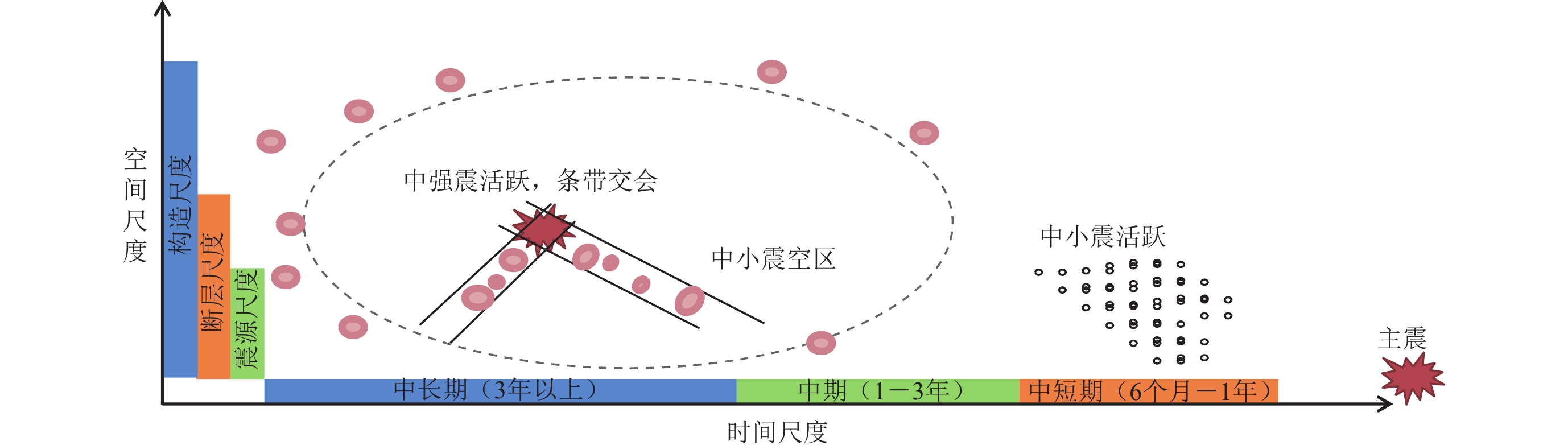
图 7 川滇菱形地块内震前地震活动增强的时空特征演化示意图
Figure 7. Schematic illustration of spatio-temporal evolution characteristics of premonitory enhanced seismicity in the Sichuan-Yunnan rhombic block
![]()
图 8 巴颜喀拉地块地震活动增强特征的时空演化示意图
Figure 8. Schematic illustration of the spatio-temporal evolution of the premonitory enhanced seismicity of the Bayan Har block
![]()
图 9 地震活动增强与大震孕育相互关系模式示意图(修改自Kato,Ben-Zion,2021)
(a) 地震活动增强引发较大范围的分布式岩石损伤;(b) 前震序列发生在大震时空紧邻区地区,岩石集中损伤;(c) 地震活动增强、前震组合形式的大震触发模型
Figure 9. Schematic illustrations of the relationship between enhanced seismicity and generation processes of strong earthquakes (modified from Kato and Ben-Zion,2021)
(a) Rock damage caused by enhanced seismicity in large scale;(b) Localization of deformation around the eventual rupture zone caused by foreshocks;(c) An integrated model including enhanced seismicity and foreshocks for the initiation of strong earthquake
表 1 本文所用具有前兆地震活动增强的震例基本信息
Table 1 Basic information of earthquake cases with premonitory enhanced seismicity used in this study
序号 发震时间
年-月-日北纬/° 东经/° MS 深度/km 地点 是否存在震前
地震活动增强1 1 966−03−22 31.50 115.00 7.2 9 邢台 是 2 1 967−03−27 38.50 116.50 6.3 30 河间 3 1 969−07−26 21.75 111.75 6.4 5 阳江 4 1 970−01−05 24.10 102.60 7.8 13 通海 5 1 973−02−06 31.50 100.40 7.6 17 炉霍 是 6 1 974−05−11 28.10 104.00 7.1 14 大关 是 7 1 975−02−04 40.70 122.80 7.3 16 海城 是 8 1 976−04−06 40.20 112.10 6.3 18 和林格尔 是 9 1 976−05−29 24.55 98.75 7.4 21 龙陵 是 10 1 976−07−28 39.60 118.20 7.8 11 唐山 是 11 1 976−08−16 32.70 104.08 7.2 15 松潘 12 1 976−09−23 40.00 106.35 6.2 35 巴音木仁 13 1 977−05−12 39.20 117.70 6.2 1 9 宁河 14 1 979−07−09 31.50 119.30 6.0 12 溧阳 15 1 979−08−25 41.23 108.11 6.0 30 五原 是 16 1 984−05−21 32.70 121.60 6.2 17 南黄海 是 17 1 985−08−23 39.58 75.60 7.4 7 乌恰 18 1 988−11−06 22.83 99.72 7.5 13 澜沧-耿马 是 1 9 1 990−04−26 36.12 100.13 7.0 32 共和 是 20 1 994−12−31 20.52 109.32 6.1 7 北部湾 21 1 995−07−12 21.98 99.07 7.3 10 孟连西 是 22 1 996−02−03 27.30 100.22 7.0 10 丽江 是 23 1 996−11−19 35.43 78.35 7.1 16 和田 是 24 1 998−01−10 41.10 114.30 6.2 10 尚义 25 2 001−11−14 35.93 90.53 8.1 10 昆仑山西口 是 26 2 008−03−21 35.80 81.43 7.3 33 于田 27 2 008−05−12 31.00 103.40 8.0 14 汶川 是 28 2 010−04−14 33.10 96.70 7.1 33 玉树 是 29 2 013−04−20 30.30 103.00 7.0 13 芦山 是 30 2 014−02−12 36.10 82.50 7.3 12 于田 31 2 017−08−08 33.20 103.82 7.0 20 九寨沟 是 32 1 989−10−19 39.94 113.84 6.1 14 大同-阳高 是 33 1 996−05−03 40.83 109.62 6.4 20 包头 是  下载: 导出CSV
-
陈棋福. 2002a. 中国震例(1992—1994)[M]. 北京:地震出版社:1−428. Chen Q F. 2002a. Earthquake Cases in China (1992−1994)[M]. Beijing:Seismological Press:1−428 (in Chinese).
陈棋福. 2002b. 中国震例(1995—1996)[M]. 北京:地震出版社:1−488. Chen Q F. 2002b. Earthquake Cases in China (1995−1996)[M]. Beijing:Seismological Press:1−488 (in Chinese).
陈棋福. 2003. 中国震例(1997—1999)[M]. 北京:地震出版社:1−468. Chen Q F. 2003. Earthquake Cases in China (1997−1999)[M]. Beijing:Seismological Press:1−468 (in Chinese).
陈棋福. 2008. 中国震例(2000—2002)[M]. 北京:地震出版社:1−570. Chen Q F. 2008. Earthquake Cases in China (2000−2002)[M]. Beijing:Seismological Press:1−570 (in Chinese).
邓起东,张培震,冉勇康,杨晓平,闵伟,楚全芝. 2002. 中国活动构造基本特征[J]. 中国科学(D辑),32(12):1020–1030. Deng Q D,Zhang P Z,Ran Y K,Yang X P,Min W,Chu Q Z. 2003. Basic characteristics of active tectonics of China[J]. Science in China:Series D,46(4):356–372. doi: 10.1360/03yd9032
国家地震局 《一九七六年唐山地震》 编辑组. 1982. 一九七六年唐山地震[M]. 北京:地震出版社:171−180. Editorial Group of 1976 Tangshan Earthquake,State Seismological Bureau. 1982. 1976 Tangshan Earthquake[M]. Beijing:Seismological Press:171−180 (in Chinese).
蒋海昆. 2014. 中国震例(2003—2006)[M]. 北京:地震出版社:1−775. Jiang H K. 2014. Earthquake Cases in China (2003−2006)[M]. Beijing:Seismological Press:1−775 (in Chinese).
蒋海昆. 2018a. 中国震例(2007—2010)[M]. 北京:地震出版社:1−513. Jiang H K. 2018a. Earthquake Cases in China (2000−2002)[M]. Beijing:Seismological Press:1−513 (in Chinese).
蒋海昆. 2018b. 中国震例(2011—2012)[M]. 北京:地震出版社:1−437. Jiang H K. 2018b. Earthquake Cases in China (2011−2012)[M]. Beijing:Seismological Press:1−437 (in Chinese).
梅世蓉. 1960. 中国的地震活动性[J]. 地球物理学报,9(1):1–19. Mei S R. 1960. Seismicity in China[J]. Acta Geophysica Sinica, 9 (1):1−19 (in Chinese).
梅世蓉. 1995. 地震前兆场物理模式与前兆时空分布机制研究(一):固体孕震模式的由来与证据[J]. 地震学报,17(3):273–282. Mei S R. 1995. On the physical model of earthquake precursor fields and the mechanism of precursors’ time and space distribution ( Ⅰ ):Origin and evidences of the strong body earthquake-generating model[J]. Acta Seismologica Sinica, 8 (3):337−349.
梅世蓉. 1996. 地震前兆场物理模式与前兆时空分布机制研究(二) :强震孕育时应力、应变场的演化与地震活动、地震前兆的关系[J]. 地震学报, 18 (1):1−10. Mei S R. 1996. Physical models of earthquake precursor fields and spatial-temporal distribution mechanisms of precursors distribution mechanism study ( Ⅱ ):Evolution of stress and strain fields in relation to seismic activity and earthquake precursors[J]. Acta Seismologica Sinica,9(1):1–12.
宋治平,梅世蓉,尹祥础. 1999. 强大地震前地震活动增强区及其力学研究[J]. 地震学报,21(3):271–277. Song Z P,Mei S R,Yin X C. 1999. On seismic strengthening area before strong and great shocks and its mechanism[J]. Acta Seismologica Sinica, 12 (3):298−305.
王筱荣. 2005. 新疆强震前地震活动增强研究[J]. 华南地震,25(1):17–23. doi: 10.3969/j.issn.1001-8662.2005.01.003 Wang X R. 2005. Research on seismicity increasing before strong earthquake in Xinjiang[J]. South China Journal of Seismology,25(1):17–23 (in Chinese).
闻学泽,杜方,张培震,龙锋. 2011. 巴颜喀拉块体北和东边界大地震序列的关联性与2008年汶川地震[J]. 地球物理学报,54(3):706–716. doi: 10.3969/j.issn.0001-5733.2011.03.010 Wen X Z,Du F,Zhang P Z,Long F. 2011. Correlation of major earthquake sequences on the northern and eastern boundaries of the Bayan Har block,and its relation to the 2008 Wenchuan earthquake[J]. Chinese Journal of Geophysics,54(3):706–716 (in Chinese).
薛丁. 2003. 包头西6.4级地震前显著中等地震活动增强和丛集异常[J]. 地震,23(4):71–76. doi: 10.3969/j.issn.1000-3274.2003.04.011 Xue D. 2003. Obvious intensifying and swarming anomaly of moderate seismic activity before west Baotou earthquake with M=6.4[J]. Earthquake,23(4):71–76 (in Chinese).
薛艳,刘杰,宋治平,黎明晓. 2018. 汶川地震前地震活动特征的普遍性及其机理探讨[J]. 地球物理学报,61(5):1891–1906. Xue Y,Liu J,Song Z P,Li M X. 2018. On the universality and mechanism interpretation of the seismicity characteristics before the 2008 Wenchuan MS8.0 earthquake[J]. Chinese Journal of Geophysics,61(5):1891–1906 (in Chinese).
晏锐,田雷,王广才,钟骏,刘杰,周志华. 2018. 2008年汶川8.0级地震前地下流体异常回顾与统计特征分析[J]. 地球物理学报,61(5):1907–1921. Yan R,Tian L,Wang G C,Zhong J,Liu J,Zhou Z H. 2018. Review and statistically characteristic analysis of underground fluid anomalies prior to the 2008 Wenchuan MS8.0 earthquake[J]. Chinese Journal of Geophysics,61(5):1907–1921 (in Chinese).
张国民,马宏生,王辉,王新岭. 2005. 中国大陆活动地块边界带与强震活动[J]. 地球物理学报,48(3):602–610. doi: 10.3321/j.issn:0001-5733.2005.03.018 Zhang G M,Ma H S,Wang H,Wang X L. 2005. Boundaries between active-tectonic blocks and strong earthquakes in the China mainland[J]. Chinese Journal of Geophysics,48(3):602–610 (in Chinese). doi: 10.1002/cjg2.693
张培震,邓起东,张国民,马瑾,甘卫军,闵伟,毛凤英,王琪. 2003. 中国大陆的强震活动与活动地块[J]. 中国科学(D辑),33(增刊1):12–20. Zhang P Z,Deng Q D,Zhang G M,Ma J,Gan W J,Min W,Mao F Y,Wang Q. 2003. Active tectonic blocks and strong earthquakes in the continent of China[J]. Science in China:Series D,46(S2):13–24. doi: 10.1360/03dz0002
张培震,闻学泽,徐锡伟,甘卫军,王敏,沈正康,王庆良,黄媛,郑勇,李小军,张竹琪,马胜利,冉勇康,刘启元,丁志峰,吴建平. 2009. 2008年汶川8.0级特大地震孕育和发生的多单元组合模式[J]. 科学通报,54(7):944–953. Zhang P Z,Wen X Z,Xu X W,Gan W J,Wang M,Shen Z K,Wang Q L,Huang Y,Zheng Y,Li X J,Zhang Z Q,Ma S L,Ran Y K,Liu Q Y,Ding Z F,Wu J P. 2009. Tectonic model of the great Wenchuan earthquake of May 12,2008,Sichuan,China[J]. Chinese Science Bulletin,54(7):944–953 (in Chinese). doi: 10.1360/csb2009-54-7-944
张肇诚. 1988. 中国震例(1966—1975)[M]. 北京:地震出版社:1−222. Zhang Z C. 1988. Earthquake Cases in China (1966−1975)[M]. Beijing:Seismological Press:1−222 (in Chinese).
张肇诚. 1990a. 中国震例(1976—1980)[M]. 北京:地震出版社:1−294. Zhang Z C. 1990a. Earthquake Cases in China (1976−1980)[M]. Beijing:Seismological Press:1−294 (in Chinese).
张肇诚. 1990b. 中国震例(1981—1985)[M]. 北京:地震出版社:1−222. Zhang Z C. 1990b. Earthquake Cases in China (1981−1985)[M]. Beijing:Seismological Press:1−222 (in Chinese).
张肇诚. 1999. 中国震例(1986—1988)[M]. 北京:地震出版社:1−394. Zhang Z C. 1999. Earthquake Cases in China (1986−1988)[M]. Beijing:Seismological Press:1−394 (in Chinese).
张肇诚. 2000. 中国震例(1989—1991)[M]. 北京:地震出版社:1−453. Zhang Z C. 2000. Earthquake Cases in China (1989−1991)[M]. Beijing:Seismological Press:1−453 (in Chinese).
中国地震局. 2005. GB/T 18207.2—2005 防震减灾术语 第2部分:专业术语[S]. 北京:中国标准出版社:13−14. China Earthquake Administration. 2005. GB/T 18207.2−2005 Terminology of Protecting Against and Mitigating Earthquake Disasters:Part 2:Special Technical Terms[S]. Beijing:Standards Press of China:13−14 (in Chinese).
中国地震局. 2007. DB/T 24-2007 震例总结规范[S]. 北京:地震出版社:4. China Earthquake Administration. 2007. DB/T 24−2007 Specification for Earthquake Case Summarization[S]. Beijing:Seismological Press:4 (in Chinese).
Abercrombie R E. 2019. Small and large earthquakes can have similar starts[J]. Nature,573(7772):42–43. doi: 10.1038/d41586-019-02613-5
Ben-Zion Y. 2008. Collective behavior of earthquakes and faults:Continuum-discrete transitions,progressive evolutionary changes,and different dynamic regimes[J]. Rev Geophys,46(4):RG4006.
Ben-Zion Y,Zaliapin I. 2020. Localization and coalescence of seismicity before large earthquakes[J]. Geophys J Int,223(1):561–583. doi: 10.1093/gji/ggaa315
Burchfiel B C,Royden L H,van der Hilst R D,Hager B H,Chen Z,King R W,Li C,Lü J,Yao H,Kirby E. 2008. A geological and geophysical context for the Wenchuan earthquake of 12 May 2008,Sichuan,People’s Republic of China[J]. GSA Today,18(7):4–11. doi: 10.1130/GSATG18A.1
Fukao Y,Furumoto M. 1985. Hierarchy in earthquake size distribution[J]. Phys Earth Planet Inter,37(2/3):149–168.
Gomberg J. 2018. Unsettled earthquake nucleation[J]. Nat Geosci,11(7):463–464. doi: 10.1038/s41561-018-0149-x
Kato A,Ben-Zion Y. 2021. The generation of large earthquakes[J]. Nat Rev Earth Environ,2(1):26–39.
Lockner D A,Byerlee J D,Kuksenko V,Ponomarev A,Sidorin A. 1991. Quasi-static fault growth and shear fracture energy in granite[J]. Nature,350(6313):39–42. doi: 10.1038/350039a0
Lyakhovsky V,Ben-Zion Y. 2009. Evolving geometrical and material properties of fault zones in a damage rheology model[J]. Geochem Geophys Geosyst,10(11):Q11011.
Lyakhovsky V,Ben-Zion Y,Agnon A. 2001. Earthquake cycle,fault zones,and seismicity patterns in a rheologically layered lithosphere[J]. J Geophys Res:Solid Earth,106(B3):4103–4120.
Mogi K. 1969. Some features of recent seismic activity in and near Japan (2):Activity before and after great earthquakes[J]. Bull Earthq Res Inst,Univ Tokyo, 47 (3):395−417.
Reches Z,Lockner D A. 1994. Nucleation and growth of faults in brittle rocks[J]. J Geophys Res:Solid Earth,99(B9):18159–18173. doi: 10.1029/94JB00115
Renard F,Mcbeck J,Kandula N,Cordonnier B,Meakin P,Ben-Zion Y. 2019. Volumetric and shear processes in crystalline rock approaching faulting[J]. Proc Natl Acad Sci USA,116(33):16234–16239. doi: 10.1073/pnas.1902994116
Ritter M C,Santimano T,Rosenau M,Leever K,Oncken O. 2018. Sandbox rheometry:Co-evolution of stress and strain in Riedel- and Critical Wedge-experiments[J]. Tectonophysics,722:400–409. doi: 10.1016/j.tecto.2017.11.018
Sadovsky M A,Nersesov I L,Nigmatullaev S K,Latynina L A,Lukk A A,Semenov A N,Simbireva I G,Ulomov V I. 1972. The processes preceding strong earthquakes in some regions of Middle Asia[J]. Tectonophysics,14(3/4):295–307.
Schrank C E,Boutelier D A,Cruden A R. 2008. The analogue shear zone:From rheology to associated geometry[J]. J Struct Geol,30(2):177–193. doi: 10.1016/j.jsg.2007.11.002
Tapponnier P,Peltzer G,Le Dain A Y,Armijo R,Cobbold P. 1982. Propagating extrusion tectonics in Asia:New insights from simple experiments with plasticine[J]. Geology,10(12):611–616. doi: 10.1130/0091-7613(1982)10<611:PETIAN>2.0.CO;2
Wan Y G,Shen Z K. 2010. Static Coulomb stress changes on faults caused by the 2008 MW7.9 Wenchuan,China earthquake[J]. Tectonophysics,491(1/2/3/4):105–118.
Wen X Z,Yi G X,Xu X W. 2007. Background and precursory seismicities along and surrounding the Kunlun fault before the MS8.1,2001,Kokoxili earthquake,China[J]. J Asian Earth Sci,30(1):63–72. doi: 10.1016/j.jseaes.2006.07.008
Добровольский ПП. 1991. Теорпя Поцотовп Тегтоппчесго нылдаов фыовлдыо[M]. Мосиова:П3в AH CCCP:1−30.
-
期刊类型引用(1)
1. 张培兴,刘紫婵,刘帅. 近景摄影测量在断裂结构精细化勘测中的应用. 价值工程. 2022(30): 142-144 .  百度学术
百度学术
其他类型引用(0)


计量
- 文章访问数: 209
- HTML全文浏览量: 54
- PDF下载量: 70
- 被引次数: 1
