

Study on the geometric distribution and active characteristics of faults in the intersection area of the Zemuhe fault,the Daliangshan fault and the Xiaojiang fault
-
摘要:
走滑断裂系的几何复杂段落可以影响大地震破裂的起始、扩展和结束,并最终决定了大地震破裂的长度和最大震级。四川宁南至云南巧家一带为青藏高原东边界则木河、大凉山和小江断裂的交会区,针对三条断裂曾开展过1 ∶ 5万活动断层填图工作,但对三条断裂的交切关系认识仍不充分,并且缺乏从断层系统的角度认识该地区断裂的几何展布和运动特征。本文针对断裂交会区开展了航片解译及详细的地质地貌调查,识别出小江断裂北段的走向在巧家以北发生约25°的偏转,形成了一个明显的弯曲构造;宁南盆地构成了则木河断裂和小江断裂的分段边界,为宽约4.5 km的拉分盆地,该地区断裂运动性质以左旋走滑兼具正断运动为主。宁南盆地及小江断裂走向上的弯曲构造共同组成了宁南—巧家拉分区,该拉分区成为东边界断裂大地震破裂传播的障碍体,而大凉山断裂和小江断裂在巧家附近交会,两者之间缺少明显的几何障碍体,很难阻止大地震破裂的传播。该断裂交会区的断裂几何展布、断裂运动特征及破裂分段等研究结果,为我们预测断裂沿线宁南、巧家和东川的强震灾害类型和特征提供了科学依据。
Abstract:The geometrically complex segments of strike-slip faults affect the initiation, propagation, and the end of major earthquake rupture, ultimately determining the rupture length and final magnitude of major earthquake. The area from Ningnan to Qiaojia is the intersection area of the Zemuhe fault on the eastern boundary fault system of the Qinghai-Xizang Plateau. Although previous 1 ∶ 50, 000 active fault mapping work has been carried out on the three faults, but the understanding of the intersection relationship of the three faults was still insufficient, and the geometric distribution and motion characteristics of the faults in this region were not understood from the perspective of the fault system. This article conducts aerial photo interpretation, drone aerial survey, and detail field investigation on the intersection area of the three faults. Based on the clarification of the geometric distribution of the three faults, we conducted targeted field investigations of the target faults and obtained the movement properties of the three faults through field geological profiles, thereby analyzing the intersection relationships among them. It is identified that the northern section of the Xiaojiang fault has undergone deflection of about 25° north of Qiaojia, and the Ningnan basin forms the segmentation boundary between the Zemuhe fault and the Xiaojiang fault, with a width of about 4.5 km pull-apart basin. Meanwhile, the Daliangshan fault experiences a minor bend across the Jinsha River and gradually connects with the Xiaojiang fault near Qiaojia, with no apparent barrier between the two.
The property of the fault movement in this area is primarily left-lateral strike-slip with some normal faulting. The Ningnan basin and the bending structure on the Xiaojiang fault constitutes the Ningnan-Qiaojia pull-apart zone. From the perspective of seismic rupture segmentation, whether earthquakes can propagate through fault junction zones determines the final magnitude and destructiveness of earthquakes. This pull-apart zone could serve as an obstacle for the propagation of large earthquakes along the eastern boundary fault. However, the Dalingshan fault and the Xiaojiang fault intersect near Qiaojia, and there is no obvious geometric barrier between them, making it difficult to impede the propagation of large earthquake ruptures. This was evident in the intensity distribution map of the earthquake that occurred near Dongchuan on August 2, 1733. The surface rupture zone was distributed near Dongchuan but extended northward to Qiaojia without deviating toward Ningnan, indicating that the major earthquake near Dongchuan failed to propagate across the approximately 4.5 km wide Ningnan basin and the bend towards the Zemuhe fault. Instead, it propagated through the junction between the northern segment of the Xiaojiang fault and the Daliangshan fault. The Xiaojiang fault and the Zemuhe fault are obstructed by bend and pull-apart basins, which could serve as segment boundaries hindering the propagation of seismic ruptures, thereby impeding the spread of earthquake energy.
Through the study of the geometric distribution and kinematic characteristics of active faults in the intersection area, the segmental features of seismic rupture are analyzed, providing a basis for predicting the types and characteristics of strong earthquake disasters in cities along the fault line. The intersection area of these faults poses a significant risk of experiencing major earthquakes. This area encompasses three cities, Ningnan County, Qiaojia County and Dongchuan City. Ningnan County is primarily located within the Ningnan pull-apart basin, with active faults mainly distributed on both sides of the basin, and no apparent active faults traversing through the interior of the basin. In the event of a strong earthquake in this area in the future, attention should be paid to the amplification effect of thick-layered Quaternary deposits within the basin on strong ground motion, leading to building damage in Ningnan County, without the risk of fault displacement, nor the need to address active fault avoidance issues. The county town of Qiaojia and Dongchuan City are situated on an active fault, with many residential buildings and schools distributed along its course, necessitating active fault detection work. Additionally, the northern segment of the Xiaojiang fault has experienced severe landslide disasters, with multiple ancient landslides distributed in the area, among which the county town of Qiaojia is located on one such ancient landslide body. Therefore, in considering the avoidance of active faults, Qiaojia must also take into account the potential impact of landslide disasters. With the completion and impoundment of the Baihetan Hydropower Station, the county town of Qiaojia has undergone relocation and reconstruction, establishing multiple centralized residential resettlement communities primarily consisting of mid-rise and high-rise buildings. These resettlement communities are located relatively close to the reservoir, and any occurrence of landslide disasters would result in significant losses and increase the difficulty of rescue efforts.
-
引言
活动断裂带的破裂分段研究对于定量评价其长期地震危险性有着重要的意义(闻学泽,2000)。走滑断层的几何结构不连续段或复杂部位,如阶区(Harris,Day,1993)、弯曲构造(Nielsen,Knopoff,1998)或分叉(Andrews,1994)等,是断层破裂分段的重要标志。它们作为走滑断层活动的障碍体,是断裂带应力分配不均匀的段落,可能影响地震破裂的起始、扩展和结束,最终控制地震的大小(Sieh et al,1993;Hamling et al,2017;Jia et al,2023)。这些尺度、几何形态及运动方式不同的障碍体,可能构成破裂传播的持久性破裂边界或非持久性破裂边界,闻学泽(2000)在鲜水河—安宁河—则木河断裂带上划分了12个特征地震破裂段,包含甘孜拉分区、慧远寺拉分区及新民过渡区、西昌转折区等,其中宁南—巧家拉分区被判定为持久性破裂边界。
断层交会区一般被认为是走滑断裂的几何分段标志,能够在一定程度上阻挡地震破裂的传播,但也有强震突破断层交会区的震例,如2023年MW7.8—7.7双震在土耳其东安纳托利亚断层系统的多个分段上发生破裂,突破了包含断层交会、弯曲和阶区等多个几何复杂段落(Jia et al,2023),这些几何复杂段落之前被认为可能为该断裂上的持久性破裂边界(Duman,Emre,2013)。针对不同几何结构对走滑断层地震破裂传播的影响及几何分段作用,前人的研究主要集中在走滑断层的阶区位置(Bai et al,2018;Shao et al,2018),对于多条分支断层交会区的研究相对较少。断裂交会区对地震破裂传播影响显著,开展宁南至巧家一带断裂交会区的几何展布及运动特征研究将为走滑断层分段研究提供实例,为该地区地震危险性评价和断裂沿线城市的活动断裂避让工作提供支撑。
1. 研究区地质构造背景
安宁河—则木河—小江断裂系位于川滇地块的东侧边界,其左旋走滑运动调节着欧亚板块碰撞造成的青藏高原向东南方向的侧向挤出(Tapponnier,Molnar,1977;Wang et al,1998;Wang,Burchfiel,2000)。作为川滇地块东侧边界的一部分,安宁河断裂—则木河断裂和大凉山断裂在石棉—巧家形成了一个宽约100 km,长约300 km的弯曲段,其西侧断裂为安宁河断裂、则木河断裂,东侧断裂为大凉山断裂(图1)。该断裂系弯曲段向西北与鲜水河断裂交会,向东南与小江断裂交会。
![]() 图 1 研究区地震构造图(国家地震局震害防御司,1995)Figure 1. Geological sketch map of the research region (Department of Seismic Damage Prevention,National Seismological Burea,1995)
图 1 研究区地震构造图(国家地震局震害防御司,1995)Figure 1. Geological sketch map of the research region (Department of Seismic Damage Prevention,National Seismological Burea,1995)地质方法得出则木河断裂带的滑动速率为4.9 mm/a (任金卫,李玶,1989)和5.8—8.5 mm/a (何宏林等,1999);大凉山断裂滑动速率约为1—4 mm/a(唐荣昌,韩渭滨,1993;申旭辉等,2000;周荣军等,2003;He et al,2008),其中南段全新世以来的滑动速率为2.5—4.5 mm/a (魏占玉等,2012);小江断裂带中段滑动速率约为(10±2)mm/a (宋方敏等,1998)和13.0—16.5 mm/a (何宏林等,2002);小江断裂带南段滑动速率为(7.02±0.20) mm/a (韩竹军等,2017)。通过GPS观测得出安宁河和则木河断裂带上长期滑动速率大致在3—5 mm/a,大凉山断裂带的左旋走滑速率为4—6.3 mm/a,小江断裂带的走滑速率约为8—13.2 mm/a,而小江断裂中南段拉张速率约为(3.7±0.2) mm/a (Shen et al,2005;Loveless,Meade,2011;Wang,Burchfiel,2000)。从滑动速率在东侧边界断裂的分布情况来看,鲜水河断裂滑动速率较高,约为12—15 mm/a (Allen et al,1991;Wang,Burchfiel,2000),向南将滑动速率分配在石棉—巧家弯曲段上,安宁河—则木河断裂和大凉山断裂上分配了大致相当的速度分量,再向南小江断裂上滑动速率约为8—13.2 mm/a,小江断裂中南段还具有明显的正断分量。
由于鲜水河—小江断裂系具有较大的滑动速率和较强的活动强度,发震能力和地震危险性均较高,中强地震频发。在研究区内,则木河断裂北段1850年9月12日在靠近西昌附近发生M7½地震,1489年和1732年发生两次M6¾地震,小江断裂北段1733年8月2日在东川附近发生M7¾地震(国家地震局震害防御司,1995)。大凉山断裂沿线虽然没有历史地震记录,但Sun等(2019)通过古地震研究揭示大凉山断裂南段的交际河段具有产生M6.5以上地震的能力,李姜一等(2020)通过形变数据和地震数据,揭示出大凉山断裂南段积累了能够发生矩震级MW7.5地震的能量,古地震离逝时间已接近地震平均复发间隔,指示大凉山断裂南段具有较高的地震危险性。
闻学泽(2000)在安宁河—则木河断裂带地震破裂分段的研究中,在则木河断裂的两端识别出了两个持久性分段边界,分别为西昌转折区和宁南—巧家拉分区(图1),认为宽约20 km的宁南—巧家拉分区内发育有北东向张性断裂和北西向正走滑断层,并沿断裂发育了宁南和巧家两个小型晚第四纪盆地,认为该拉分区以发育张破裂和断陷盆地的方式来调节小江断裂带西侧地块向南的水平运动,而拉分区的西侧则以局部的挤压抬升来调节则木河断裂带西侧的位移量。宁南、巧家一带形成的断陷盆地内堆积了大量的中-上更新统沉积物(闻学泽,1983)。由于缺少对断裂交会区活动断裂的精细化研究,使得对于这一地区活动断裂的几何展布特征和交切关系认识仍不充分。
2. 方法与数据
本文主要通过航片解译和地表调查相结合的方式,对研究区的三条分支断层开展几何展布、运动特征和交切关系的研究。由于研究区内金沙江上白鹤滩水电站的建成,造成巧家、宁南大片地区被水库淹没,且巧家县城也进行了大规模的开发和建设,这些因素都限制了我们对断裂交会区地质地貌特征的研究(图2)。鉴于此,我们收集了研究区20世纪70至80年代国家测绘局拍摄的1 ∶ 5万比例尺航片,进行了详细的航片解译工作,获取了水库蓄水前研究区内三条断裂的精细几何展布(图3)。在查清三条断裂几何展布的基础上,我们对目标断层开展了有针对性的野外调查,通过野外地质剖面获得三条断裂的运动性质,进而解析三者之间的交切关系。通过对断层交会区几何展布和运动性质的梳理,结合1733年东川M7¾地震破裂分布,提出则木河—大凉山—小江断裂交会区的几何分段方案,并对断裂沿线不同城市与断裂的空间位置关系提出活断层避让建议。
![]() 图 2 断裂交会区几何展布及工作点分布图Figure 2. Geometric distribution and working points distribution map of fault intersection area
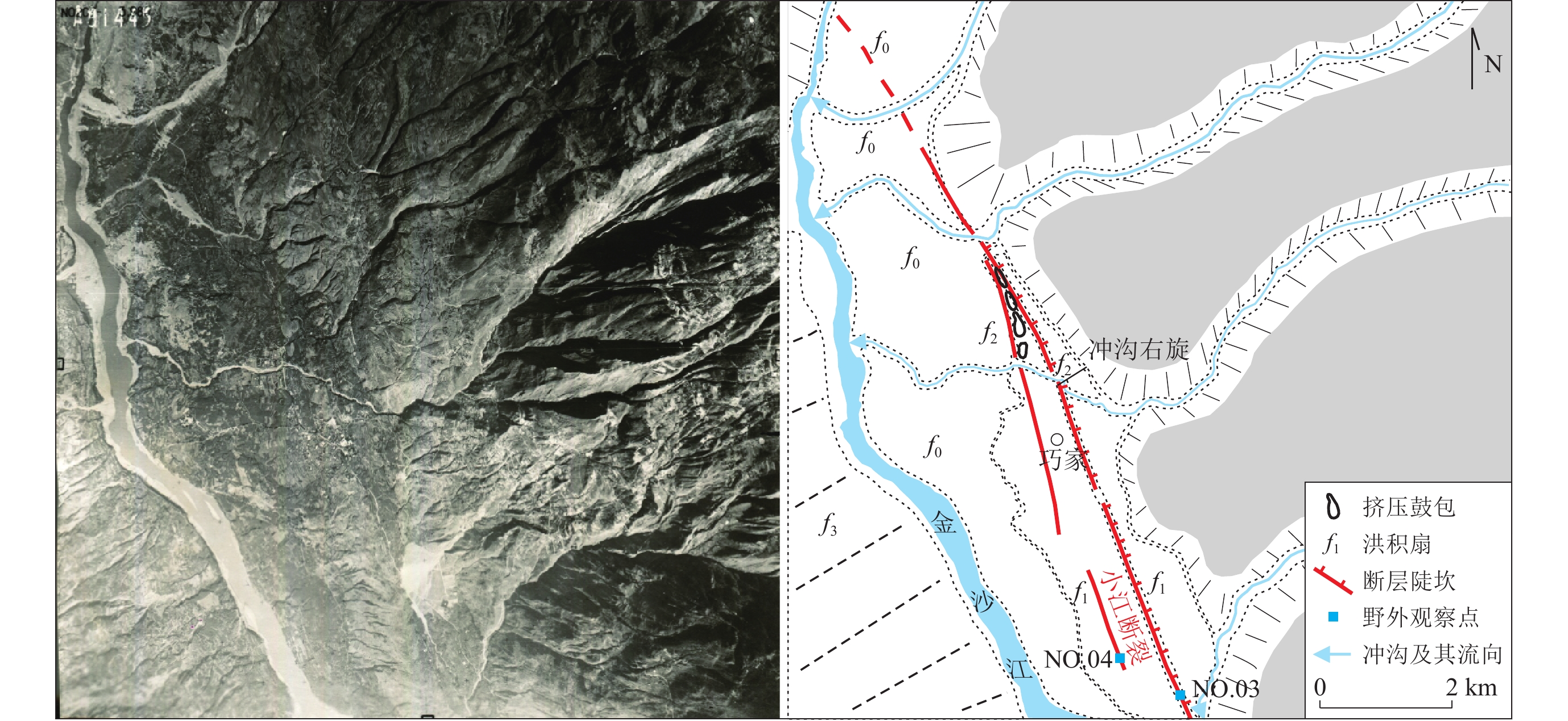
图 2 断裂交会区几何展布及工作点分布图Figure 2. Geometric distribution and working points distribution map of fault intersection area![]() 图 3 巧家县城附近航片及解译图Figure 3. Aerial photographs and interpretation maps near Qiaojia County
图 3 巧家县城附近航片及解译图Figure 3. Aerial photographs and interpretation maps near Qiaojia County3. 断裂几何展布及运动特征调查
3.1 则木河断裂
则木河断裂北接安宁河断裂带,西北起自西昌,向东南经普格到达宁南附近,越过宁南盆地与小江断裂带相接,全长约150 km。断裂走向NNW,总体走向有着较好的一致性,晚第四纪以来断层变形以左旋走滑运动为主,兼具正断运动(图1)(闻学泽,1983)。则木河断裂尾端发育有宁南盆地,则木河断裂在宁南盆地西南侧山前发育有两条分支断层(NO.01,102°43′12.54″E,27°3′24.87″N),地貌上表现为两条近平行的断层陡坎(图4a),跨陡坎的剖面处可见到断层断错第四系地层(图4b,c),断裂倾向北东并表现为左旋兼拉张运动性质。
![]() 图 4 宁南县西南侧则木河断裂地貌特征(a)及观察点1附近断层剖面(b−d)Figure 4. Geomorphic characteristics (a) of the Zemuhe fault in southwest Ningnan County and fault cross-section near site 1 (b−d)
图 4 宁南县西南侧则木河断裂地貌特征(a)及观察点1附近断层剖面(b−d)Figure 4. Geomorphic characteristics (a) of the Zemuhe fault in southwest Ningnan County and fault cross-section near site 1 (b−d)穿过银厂沟,可见到断裂继续向东南方向延伸,表现为线性较好的基岩三角面,在断层露头处可见到两组近平行的断层面(NO.02,102°43′51.68″E,27°2′35.24″N)(图5)。主干断裂为基岩与第四系的分界线,断层断错第四系地层,在主干断层附近又发育有多条分支断层,分支断层有发育在基岩内部的,也有发育在第四系内部的,断裂倾向北东,整体表现为走滑兼拉张运动性质。
![]() 图 5 宁南县西南侧则木河断裂地貌特征(a)及观察点2断层剖面(b,c)Figure 5. Geomorphology of the Zemuhe fault in southwest Ningnan County (a) and fault profile of site 2 (b,c)
图 5 宁南县西南侧则木河断裂地貌特征(a)及观察点2断层剖面(b,c)Figure 5. Geomorphology of the Zemuhe fault in southwest Ningnan County (a) and fault profile of site 2 (b,c)3.2 小江断裂北段
小江断裂中北段以东川为界,可以分为南北两个段落,东川至巧家段以单条断层为主,长约75 km,主要展布于金沙江、小江河谷,表现为洪积扇的左旋位错和反向陡坎发育(图1);而东川向南分为两条分支断层,宽度约为15 km,西支主要为1833年嵩明M8地震地表破裂段,而东支主要为1733年东川M7¾地震地表破裂段(何宏林等,2002)。
通过影像解译,小江断裂带北段在巧家附近可见到两条分支断层(图3),主要表现为左旋走滑-拉张的运动性质。其中主干断裂在地貌上总体表现为倾向北东的反向槽谷,线性特征较好,断裂沿线还发育有多处泉眼,在开挖处还可见到清晰的基岩断层面(NO.03,102°56′41.97″E,26°52′42.60″N)(图6)。
![]() 图 6 巧家县城附近小江断裂地貌特征(a)及观察点3断层照片(b)Figure 6. Geomorphic characteristics (a) and fault photos of site 3 (b) on the Xiaojiang fault near Qiaojia County
图 6 巧家县城附近小江断裂地貌特征(a)及观察点3断层照片(b)Figure 6. Geomorphic characteristics (a) and fault photos of site 3 (b) on the Xiaojiang fault near Qiaojia County另外在主干断层西侧可见一条发育在洪积扇内部的、断错砾石层的分支断层(NO.04,102°56′11.24″E,26°52′43.45″N)(图7),断裂发育在早中更新世砾石层中,由于缺少上覆地层出露,该分支断层最新活动时代仍不明确。
![]() 图 7 巧家县城附近观察点4处小江断裂分支断层照片Figure 7. Branch fault photos of site4 on Xiaojiang fault near Qiaojia County
图 7 巧家县城附近观察点4处小江断裂分支断层照片Figure 7. Branch fault photos of site4 on Xiaojiang fault near Qiaojia County断裂在巧家县城以北穿过金沙江向西北方向延伸,断裂走向由北北西转变为北西方向,走向偏转约25°。在宁南县城东南侧可见一个宽约80 m的断层破碎带(NO.05,102°51′28.80″E,26°58′51.37″N)(图8),在破碎带内发育有多条分支断裂,局部暴露在外的断层破碎带还可见到垂直擦痕,断裂表现为倾向南西的正断层,显示在此处小江断裂运动性质具有明显的正断分量。
3.3 大凉山断裂
大凉山断裂带北起石棉附近,向南经越西、普雄、昭觉、布托至巧家汇入小江断裂带,全长约280 km (图1)。大凉山断裂带是一条新生的断裂带,对鲜水河—小江断裂系中段产生“截弯取直”的作用,由6条斜列分支断裂组成,由北向南分别为竹马断裂、公益海断裂、越西断裂、普雄断裂、布拖断裂和交际河断裂(He et al,2008)。其中,位于其南段的布拖断裂和交际河断裂呈右阶斜列展布,断裂长度分别为60 km和70 km (魏占玉等,2012),交际河断裂穿过金沙江向南的几何展布及运动特征仍缺乏研究(图2)。
交际河断裂南段总体表现为走滑兼正断的运动性质,在金沙江北岸可见到断裂表现为倾向北东的拉张运动性质,断层三角面出露,一直延伸至金沙江南岸(图9),在断裂走向转弯处,可见到断层断错晚第四系褐红色黏土层的断层剖面(NO.06,102°54′17.77″E,27°1′19.92″N)。由弯折处向南延伸至巧家附近,断裂逐渐歼灭。
![]() 图 9 金沙江南岸大凉山断裂观察点6地貌特征(a)及断层剖面(b)Figure 9. Geomorphic characteristics (a) and fault cross-section (b) of the Daliangshan fault on the south bank of the Jinsha River
图 9 金沙江南岸大凉山断裂观察点6地貌特征(a)及断层剖面(b)Figure 9. Geomorphic characteristics (a) and fault cross-section (b) of the Daliangshan fault on the south bank of the Jinsha River4. 讨论
本文通过详细的航卫片解译和野外调查,揭示出小江断裂北段走向在巧家以北向西偏转了约25°,形成一个明显的弯曲构造,断裂继续延伸至宁南盆地东南侧,与则木河断裂南段形成了宽约4.5 km的拉分盆地,弯曲构造和宁南拉分盆地共同构成了宁南—巧家拉分区。而大凉山断裂跨越金沙江发生了小的弯折,在巧家附近逐渐与小江断裂相连,两者之间未见有明显的障碍体。巧家至宁南段长约20 km的断裂之所以划归为小江断裂北段,而未划归为则木河断裂东南段,一是它与巧家附近小江断裂有较好的几何连续性,小江断裂从东川北一直可以追索到巧家、宁南盆地东侧;二是该段断裂与则木河断裂之间发育有宁南盆地,该盆地在很大程度上能阻隔地震破裂的传播,使得其与则木河断裂形成明显的几何分段。
从地震破裂分段的角度来看,地震能否突破断层交会区进行传播,决定了地震最终的震级及其破坏性(Jia et al,2023)。由于小江断裂和大凉山断裂缺少明显的几何障碍体阻挡,在巧家附近走向一致,地震破裂很容易贯穿两条断裂,这在1733年8月2日东川附近发生的M7¾地震裂度图中有所体现(图10)(国家地震局震害防御司,1995)。该地震地表破裂带分布在东川附近,但裂度分布延伸至巧家以北,而未发生偏转延伸至宁南附近。这说明在东川附近发生的大地震未能突破宁南—巧家拉分区向则木河断裂上传播,而是贯通了小江断裂北段和大凉山断裂交际河段。小江断裂与则木河断裂受到弯曲构造和拉分盆地的阻挡,宁南—巧家拉分区可能成为地震破裂的分段边界,阻挡地震破裂的传播;而小江断裂与交际河断裂的联系更加紧密,断裂交会处未见有明显的几何分段标志,两者之上发生大地震很容易彼此贯通。
![]() 图 10 1733年8月2日东川M7¾地震烈度图(国家地震局震害防御司,1995)Figure 10. Seismic intensity map of the M7¾ Dongchuan earthquake on 2 August 1733 (Department of Seismic DamagePrevention,National Seismo-logical Bureau,1995)
图 10 1733年8月2日东川M7¾地震烈度图(国家地震局震害防御司,1995)Figure 10. Seismic intensity map of the M7¾ Dongchuan earthquake on 2 August 1733 (Department of Seismic DamagePrevention,National Seismo-logical Bureau,1995)通过对该断裂交会区活动断裂几何展布和运动特征的研究,解析了地震破裂的分段特征,为我们预测断裂沿线城市的强震灾害类型和特征提供了依据。该地区共分布有宁南县、巧家县和东川市三个县市,其中,宁南县城位于小江断裂和则木河断裂左阶斜列形成的拉分盆地内,活动断裂主要分布于宁南盆地的两侧,未见有活动断裂从盆地内部穿过。小江断裂北段发育有多条分支断层,该段为1733年东川M7¾地震破裂段,主干断裂直接穿越巧家县城和东川城区,而且小江断裂北段遭受严重滑坡灾害,分布有多个古滑坡体,其中巧家县城就位于古滑坡体之上(刘莉等,2022)。未来这一地区发生强震,宁南县城应注意盆地内厚层状第四系沉积对强地震动的放大效应,会对建筑物造成破坏,但不会有活动断层断错的风险,不涉及到活动断层避让问题。而巧家和东川均有活动断层穿城而过,需要考虑活动断层避让问题,另外,巧家附近活动断层沿线分布有大量居民区和学校等,需要开展活动断层探测工作;巧家县城在考虑活动断层避让的同时,还需要考虑滑坡灾害的影响,随着白鹤滩水电站的建成蓄水,巧家县城经搬迁重建后,建成了北门、天生梁子和邱家屿等多个居民集中安置区,以中高层、高层建筑为主,这些居民安置区距离水库较近,一旦发生滑坡灾害,将造成较大损失,且救灾难度很大。
5. 结论
通过影像解译和野外调查,对宁南至巧家附近大凉山—则木河—小江断裂交会区的断层几何展布和运动特征进行了研究,该地区为拉张应力环境,三条断层主要表现为左旋走滑兼拉张的运动性质,并识别出小江断裂在巧家以北发生了25°的北西向偏转,延伸至宁南盆地东北侧终止,与则木河断裂呈左行左阶展布,形成宁南拉分盆地;而大凉山断裂交际河段跨越金沙江向南延伸,在巧家附近逐渐与小江断裂交会,两者之间没有明显的分段边界。
在该地区发生强烈地震,宁南—巧家拉分区的拉分盆地和弯曲构造在很大程度上能够阻止地震破裂的传播,而大凉山断裂和小江断裂之间由于缺少明显几何障碍体的阻挡,大地震破裂的传播可能贯通两条断裂。活动断裂在巧家和东川两地穿城而过,应开展城市活动断层探测工作。
-
![]()
图 1 研究区地震构造图(国家地震局震害防御司,1995)
Figure 1. Geological sketch map of the research region (Department of Seismic Damage Prevention,National Seismological Burea,1995)
![]()
图 2 断裂交会区几何展布及工作点分布图
Figure 2. Geometric distribution and working points distribution map of fault intersection area
![]()
图 3 巧家县城附近航片及解译图
Figure 3. Aerial photographs and interpretation maps near Qiaojia County
![]()
图 4 宁南县西南侧则木河断裂地貌特征(a)及观察点1附近断层剖面(b−d)
Figure 4. Geomorphic characteristics (a) of the Zemuhe fault in southwest Ningnan County and fault cross-section near site 1 (b−d)
![]()
图 5 宁南县西南侧则木河断裂地貌特征(a)及观察点2断层剖面(b,c)
Figure 5. Geomorphology of the Zemuhe fault in southwest Ningnan County (a) and fault profile of site 2 (b,c)
![]()
图 6 巧家县城附近小江断裂地貌特征(a)及观察点3断层照片(b)
Figure 6. Geomorphic characteristics (a) and fault photos of site 3 (b) on the Xiaojiang fault near Qiaojia County
![]()
图 7 巧家县城附近观察点4处小江断裂分支断层照片
Figure 7. Branch fault photos of site4 on Xiaojiang fault near Qiaojia County
![]()
图 9 金沙江南岸大凉山断裂观察点6地貌特征(a)及断层剖面(b)
Figure 9. Geomorphic characteristics (a) and fault cross-section (b) of the Daliangshan fault on the south bank of the Jinsha River
![]()
图 10 1733年8月2日东川M7¾地震烈度图(国家地震局震害防御司,1995)
Figure 10. Seismic intensity map of the M7¾ Dongchuan earthquake on 2 August 1733 (Department of Seismic DamagePrevention,National Seismo-logical Bureau,1995)
-
国家地震局震害防御司. 1995. 中国历史强震目录[M]. 北京:地震出版社:1−514. Department of Seismic Damage Prevention,National Seismological Bureau. 1995. The Catalogue of Chinese Historical Earthquakes[M]. Beijing:Seismological Press:1−514 (in Chinese).
韩竹军,董绍鹏,毛泽斌,呼楠,谭锡斌,袁仁茂,郭鹏. 2017. 小江断裂带南段全新世活动的地质地貌证据与滑动速率[J]. 地震地质,39(1):1–19. Han Z J,Dong S P,Mao Z B,Hu N,Tan X B,Yuan R M,Guo P. 2017. The Holocene activity and strike-slip rate of the southern segment of Xiaojiang fault in the southeastern Yunnan region,China[J]. Seismology and Geology,39(1):1–19 (in Chinese).
何宏林,宋方敏,李传友. 1999. 四川则木河断裂带微断层地貌的地形测量和走滑速率的估算(英文)[J]. 地震地质,21(4):361–369. doi: 10.3969/j.issn.0253-4967.1999.04.010 He H L,Song F M,Li C Y. 1999. Topographic survey of micro faulted landform and estimation of strike slip rate for the Zemuhe fault,Sichuan Province[J]. Seismology and Geology,21(4):361–369.
何宏林,池田安隆,宋方敏,董兴权. 2002. 小江断裂带第四纪晚期左旋走滑速率及其构造意义(英文)[J]. 地震地质,24(1):14–26. doi: 10.3969/j.issn.0253-4967.2002.01.002 He H L,Ikeda Y,Song F M,Dong X Q. 2002. Late Quaternary slip rate of the Xiaojiang fault and its implication[J]. Seismology and Geology,24(1):14–26.
李姜一,周本刚,李铁明,杨永林,李正芳,龙锋. 2020. 安宁河—则木河断裂带和大凉山断裂带孕震深度研究及其地震危险性[J]. 地球物理学报,63(10):3669–3682. Li J Y,Zhou B G,Li T M,Yang Y L,Li Z F,Long F. 2020. Seismogenic depths of the Anninghe-Zemuhe and Daliangshan fault zones and their seismic hazards[J]. Chinese Journal of Geophysics,63(10):3669–3682 (in Chinese).
刘莉,张丽萍,李萍,杨鑫,邓清海. 2022. 金沙江巧家巨型古滑坡发育特征及其形成条件[J]. 人民长江,53(1):118–125. Liu L,Zhang L P,Li P,Yang X,Deng Q H. 2022. Development characteristics and forming conditions of Qiaojia giant ancient landslide in Jinsha River[J]. Yangtze River,53(1):118–125 (in Chinese).
任金卫,李玶. 1989. 则木河断裂带北段地震地貌及古地震研究[J]. 地震地质,11(1):27–34. Ren J W,Li P. 1989. Earthquake-caused landforms and paleoseismic study on the Northern segment of the Zemuhe fault[J]. Seismology and Geology,11(1):27–34 (in Chinese).
申旭辉,陈正位,许任德,张宁. 2000. 凉山活动构造带晚新生代变形特征与位移规模[J]. 地震地质,22(3):232–238. Shen X H,Chen Z W,Xu R D,Zhang N. 2000. Deformation characteristics and displacement amount of the Liangshan active fault zone in Late Cenozoic Era[J]. Seismology and Geology,22(3):232–238 (in Chinese).
宋方敏,汪一鹏,俞维贤,曹忠权,申旭辉,沈军. 1998. 小江活动断裂带[M]. 北京:地震出版社:1−237. Song F M,Wang Y P,Yu W X,Cao Z Q,Shen X H,Shen J. 1998. Xiaojiang Active Fault Zone[M]. Beijing:Seismological Press:1−237 (in Chinese).
唐荣昌,韩渭滨. 1993. 四川活动断裂与地震[M]. 北京:地震出版社:1−368. Tang R C,Han W B. 1993. Active Fault and Earthquake in Sichuan Province[M]. Beijing:Seismological Press:1−368 (in Chinese).
魏占玉,何宏林,石峰,徐岳仁,毕丽思,孙浩越. 2012. 大凉山断裂带南段滑动速率估计[J]. 地震地质,34(2):282–293. Wei Z Y,He H L,Shi F,Xu Y R,Bi L S,Sun H Y. 2012. Slip rate on the South segment of Daliangshan fault zone[J]. Seismology and Geology,34(2):282–293 (in Chinese).
闻学泽. 1983. 则木河断裂的第四纪构造活动模式[J]. 地震研究,6(1):41–50. Wen X Z. 1983. Model of active tectonic of the Quaternary period of Zemu river fault[J]. Journal of Seismological Research,6(1):41–50 (in Chinese).
闻学泽. 2000. 四川西部鲜水河—安宁河—则木河断裂带的地震破裂分段特征[J]. 地震地质,22(3):239–249. Wen X Z. 2000. Character of rupture segmentation of the Xianshuihe-Anninghe-Zemuhe fault zone,Western Sichuan[J]. Seismology and Geology,22(3):239–249 (in Chinese).
周荣军,黎小刚,黄祖智,何玉林,戈天勇. 2003. 四川大凉山断裂带的晚第四纪平均滑动速率[J]. 地震研究,26(2):191–196. Zhou R J,Li X G,Huang Z Z,He Y L,Ge T Y. 2003. Average slip rate of Daliang mountain fault zone in Sichuan in Late Quaternary period[J]. Journal of Seismological Research,26(2):191–196 (in Chinese).
Allen C R,Luo Z L,Qian H,Wen X Z,Zhou H W,Huang W S. 1991. Field study of a highly active fault zone:The Xianshuihe fault of southwestern China[J]. GSA Bull,103(9):1178–1199. doi: 10.1130/0016-7606(1991)103<1178:FSOAHA>2.3.CO;2
Andrews D J. 1994. Fault geometry and earthquake mechanics[J]. Ann Geophys,37(6):1341–1348.
Bai M K,Chevalier M L,Pan J W,Replumaz A,Leloup P H,Métois M,Li H B. 2018. Southeastward increase of the Late Quaternary slip-rate of the Xianshuihe fault,eastern Tibet. Geodynamic and seismic hazard implications[J]. Earth Planet Sci Lett,485:19–31.
Duman T Y, Emre Ö. 2013. The East Anatolian Fault: Geometry, segmentation and jog characteristics[J]. Geo Soc London Special Pub,372(1):495–529. doi: 10.1144/SP372.14
Hamling I J,Hreinsdóttir S,Clark K,Elliott J,Liang C R,Fielding E,Litchfield N,Villamor P,Wallace L,Wright T J,D'Anastasio E,Bannister S,Burbidge D,Denys P,Gentle P,Howarth J,Mueller C,Palmer N,Pearson C,Power W,Barnes P,Barrell D J A,Van Dissen R,Langridge R,Little T,Nicol A,Pettinga J,Rowland J,Stirling M. 2017. Complex multifault rupture during the 2016 MW7.8 Kaikōura earthquake,New Zealand[J]. Science,356(6334):eaam7194. doi: 10.1126/science.aam7194
Harris R A,Day S M. 1993. Dynamics of fault interaction:Parallel strike-slip faults[J]. J Geophys Res:Solid Earth,98(B3):4461–4472. doi: 10.1029/92JB02272
He H L,Ikeda Y,He Y L,Togo M,Chen J,Chen C Y,Tajikara M,Echigo T,Okada S. 2008. Newly-generated Daliangshan fault zone:Shortcutting on the central section of Xianshuihe−Xiaojiang fault system[J]. Science China:Earth Sciences,51(9):1248–1258. doi: 10.1007/s11430-008-0094-4
Jia Z,Jin Z Y,Marchandon M,Ulrich T,Gabriel A A,Fan W Y,Shearer P,Zou X Y,Rekoske J,Bulut F,Garagon A,Fialko Y. 2023. The complex dynamics of the 2023 Kahramanmaraş,Turkey,MW7.8−7.7 earthquake doublet[J]. Science,381(6661):985–990.
Loveless J P,Meade B J. 2011. Partitioning of localized and diffuse deformation in the Tibetan Plateau from joint inversions of geologic and geodetic observations[J]. Earth Planet Sci Lett,303(1/2):11–24.
Nielsen S B,Knopoff L. 1998. The equivalent strength of geometrical barriers to earthquakes[J]. J Geophys Res:Solid Earth,103(B5):9953–9965. doi: 10.1029/97JB03293
Shao Y X,Liu-Zeng J,Oskin M E,Elliott A J,Wang P,Zhang J Y,Yuan Z D,Li Z F. 2018. Paleoseismic investigation of the Aksay restraining double bend,Altyn Tagh fault,and its implication for barrier-breaching ruptures[J]. J Geophys Res:Solid Earth,123(5):4307–4330.
Shen Z K,Lü J N,Wang M,Bürgmann R. 2005. Contemporary crustal deformation around the southeast borderland of the Tibetan Plateau[J]. J Geophys Res:Solid Earth,110(B11):B11409.
Sieh K,Jones L,Hauksson E,Hudnut K,Eberhart-Phillips D,Heaton T,Hough S,Hutton K,Kanamori H,Lilje A,Lindvall S,McGill S F,Mori J,Rubin C,Spotila J A,Stock J,Thio H K,Treiman J,Wernicke B,Zachariasen J. 1993. Near-field investigations of the Landers earthquake sequence,April to July 1992[J]. Science,260(5105):171–176. doi: 10.1126/science.260.5105.171
Sun H Y,He H L,Ikeda Y,Wei Z Y,Chen C Y,Xu Y R,Shi F,Bi L S,Shirahama Y,Okada S,Echigo T. 2019. Paleoearthquake history along the southern segment of the Daliangshan fault zone in the southeastern Tibetan Plateau[J]. Tectonics,38(7):2208–2231.
Tapponnier P,Molnar P. 1977. Active faulting and tectonics in China[J]. J Geophys Res,82(20):2905–2930. doi: 10.1029/JB082i020p02905
Wang E,Burchfiel B C,Royden L H,Chen L Z,Chen J S,Li W X,Chen Z L. 1998. Late Cenozoic Xianshuihe-Xiaojiang,Red River,and Dali Fault Systems of Southwestern Sichuan and Central Yunnan,China[M]. Boulder:Geological Society of America:1−108.
Wang E,Burchfiel B C. 2000. Late Cenozoic to Holocene deformation in southwestern Sichuan and adjacent Yunnan,China,and its role in formation of the southeastern part of the Tibetan Plateau[J]. GSA Bull,112(3):413–423. doi: 10.1130/0016-7606(2000)112<413:LCTHDI>2.0.CO;2
 下载:
下载:


计量
- 文章访问数: 118
- HTML全文浏览量: 48
- PDF下载量: 48
