

Study on the geometric distribution and active characteristics of faults in the intersection area of the Zemuhe fault,the Daliangshan fault and the Xiaojiang fault
-
摘要:
走滑断裂系的几何复杂段落可以影响大地震破裂的起始、扩展和结束,并最终决定了大地震破裂的长度和最大震级。四川宁南至云南巧家一带为青藏高原东边界则木河、大凉山和小江断裂的交会区,针对三条断裂曾开展过1 ∶ 5万活动断层填图工作,但对三条断裂的交切关系认识仍不充分,并且缺乏从断层系统的角度认识该地区断裂的几何展布和运动特征。本文针对断裂交会区开展了航片解译及详细的地质地貌调查,识别出小江断裂北段的走向在巧家以北发生约25°的偏转,形成了一个明显的弯曲构造;宁南盆地构成了则木河断裂和小江断裂的分段边界,为宽约4.5 km的拉分盆地,该地区断裂运动性质以左旋走滑兼具正断运动为主。宁南盆地及小江断裂走向上的弯曲构造共同组成了宁南—巧家拉分区,该拉分区成为东边界断裂大地震破裂传播的障碍体,而大凉山断裂和小江断裂在巧家附近交会,两者之间缺少明显的几何障碍体,很难阻止大地震破裂的传播。该断裂交会区的断裂几何展布、断裂运动特征及破裂分段等研究结果,为我们预测断裂沿线宁南、巧家和东川的强震灾害类型和特征提供了科学依据。
Abstract:The geometrically complex segments of strike-slip faults affect the initiation, propagation, and the end of major earthquake rupture, ultimately determining the rupture length and final magnitude of major earthquake. The area from Ningnan to Qiaojia is the intersection area of the Zemuhe fault on the eastern boundary fault system of the Qinghai-Xizang Plateau. Although previous 1 ∶ 50, 000 active fault mapping work has been carried out on the three faults, but the understanding of the intersection relationship of the three faults was still insufficient, and the geometric distribution and motion characteristics of the faults in this region were not understood from the perspective of the fault system. This article conducts aerial photo interpretation, drone aerial survey, and detail field investigation on the intersection area of the three faults. Based on the clarification of the geometric distribution of the three faults, we conducted targeted field investigations of the target faults and obtained the movement properties of the three faults through field geological profiles, thereby analyzing the intersection relationships among them. It is identified that the northern section of the Xiaojiang fault has undergone deflection of about 25° north of Qiaojia, and the Ningnan basin forms the segmentation boundary between the Zemuhe fault and the Xiaojiang fault, with a width of about 4.5 km pull-apart basin. Meanwhile, the Daliangshan fault experiences a minor bend across the Jinsha River and gradually connects with the Xiaojiang fault near Qiaojia, with no apparent barrier between the two.
The property of the fault movement in this area is primarily left-lateral strike-slip with some normal faulting. The Ningnan basin and the bending structure on the Xiaojiang fault constitutes the Ningnan-Qiaojia pull-apart zone. From the perspective of seismic rupture segmentation, whether earthquakes can propagate through fault junction zones determines the final magnitude and destructiveness of earthquakes. This pull-apart zone could serve as an obstacle for the propagation of large earthquakes along the eastern boundary fault. However, the Dalingshan fault and the Xiaojiang fault intersect near Qiaojia, and there is no obvious geometric barrier between them, making it difficult to impede the propagation of large earthquake ruptures. This was evident in the intensity distribution map of the earthquake that occurred near Dongchuan on August 2, 1733. The surface rupture zone was distributed near Dongchuan but extended northward to Qiaojia without deviating toward Ningnan, indicating that the major earthquake near Dongchuan failed to propagate across the approximately 4.5 km wide Ningnan basin and the bend towards the Zemuhe fault. Instead, it propagated through the junction between the northern segment of the Xiaojiang fault and the Daliangshan fault. The Xiaojiang fault and the Zemuhe fault are obstructed by bend and pull-apart basins, which could serve as segment boundaries hindering the propagation of seismic ruptures, thereby impeding the spread of earthquake energy.
Through the study of the geometric distribution and kinematic characteristics of active faults in the intersection area, the segmental features of seismic rupture are analyzed, providing a basis for predicting the types and characteristics of strong earthquake disasters in cities along the fault line. The intersection area of these faults poses a significant risk of experiencing major earthquakes. This area encompasses three cities, Ningnan County, Qiaojia County and Dongchuan City. Ningnan County is primarily located within the Ningnan pull-apart basin, with active faults mainly distributed on both sides of the basin, and no apparent active faults traversing through the interior of the basin. In the event of a strong earthquake in this area in the future, attention should be paid to the amplification effect of thick-layered Quaternary deposits within the basin on strong ground motion, leading to building damage in Ningnan County, without the risk of fault displacement, nor the need to address active fault avoidance issues. The county town of Qiaojia and Dongchuan City are situated on an active fault, with many residential buildings and schools distributed along its course, necessitating active fault detection work. Additionally, the northern segment of the Xiaojiang fault has experienced severe landslide disasters, with multiple ancient landslides distributed in the area, among which the county town of Qiaojia is located on one such ancient landslide body. Therefore, in considering the avoidance of active faults, Qiaojia must also take into account the potential impact of landslide disasters. With the completion and impoundment of the Baihetan Hydropower Station, the county town of Qiaojia has undergone relocation and reconstruction, establishing multiple centralized residential resettlement communities primarily consisting of mid-rise and high-rise buildings. These resettlement communities are located relatively close to the reservoir, and any occurrence of landslide disasters would result in significant losses and increase the difficulty of rescue efforts.
-
引言
与地震相关的热辐射研究始于20世纪80年代(Gorny et al,1988;Tronin,1996),自此国内外不少研究人员进行了与此相关的研究(强祖基等,1990;刘德富等,1999;Tramutoli et al,2001;Saraf,Choudhury,2003;Choudhury et al,2006)。地表温度场中存在着与活动构造带密切相关的热信息,地震前后温度场的变化与同震形变观测结果相吻合(马瑾等,2010;陈顺云等,2014),与地震活动相关的热异常也已得到论证(邓志辉等,2003;Ouzounov,Freund,2004)。Tronin等(2004)研究了2003年12月26日伊朗巴姆MW6.6地震得出,震前4天出现陆面温度(land surface temperature,简写为LST)增温,幅度为7°C—10°C;Saraf等(2012)分析2011年1月19日达尔本丁MS7.2地震得出震前两天LST增温异常幅度达8°C—10°C,增温面积约为6×10⁴ km2。近年来国内研究人员在此方面的研究取得了一定进展(魏乐军等,2008;康春丽等,2011;解滔等,2015),大量震例的研究结果表明,强震前确实存在热辐射异常。张元生等(2010)根据地表热辐射影响因素所具有的不同周期,利用小波变换法去除影响因素,从而有效地提取地震热异常,并对2008年汶川、于田、乌恰地震进行了热辐射变化分析,分析结果显示这3次地震在发震前均呈现明显的热异常特征,进而总结出发震区域一般位于异常区边缘及区内的活动断层上,发震时间在功率谱达到峰值之后的35天内。其它的相关研究还有很多(张璇等,2013;李青梅等,2015),这些研究成果在发震地点和发震时间上意义明确,也可为短期地震预测提供经验。
在大量震例研究的基础上,目前已形成了多种热异常提取方法,这些方法主要是通过对比地震前后卫星热红外亮温图像的变化来识别异常。随着该领域研究的不断深入,又发展出一些新的研究方法。例如:Tramutoli等(2001)提出的“稳健卫星技术”(robust satellite techniques,简写为RST)反映了时空域上的地震热辐射异常信息;陈梅花等(2007)将“断层带内外温差法”用于研究1997年玛尼MS7.5地震,尽管受到降雪等因素的干扰,但还是有效地提取到了地震前的增温信息,震后相对亮温差恢复至正常状态;郭晓等(2010)通过研究强震长波辐射异常变化时提出“功率谱相对变化法”,并使用该方法对中国大陆6次MS6.5地震进行分析,结果表明震前均出现了不同程度的功率谱幅值增强现象;温少妍(2011)利用“历年同期亮温偏移指数法”研究2008年汶川MS8.0地震和2010年玉树MS7.1地震,得出了二者亮温异常的时空演化规律;解滔等(2015)使用“连续小波变换法”对于田地震的亮温异常进行了研究。地震热红外异常成因机理方面的探索也取得了一定进展,但目前尚未形成统一认识,主要有以下几种观点:① 地球放气-电磁增温说。震前应力积累变化使地下气体(如CO2,CH4)沿微裂隙溢出,辐射增强,另外地壳活动强烈时电磁场会出现异常,和太阳辐射一并促进温室气体的热辐射,进而在震源区附近出现大面积、高幅度热异常(强祖基等, 1992,1998);② 应变能转换说。吴立新等(2001)的撞击瞬态监测试验显示撞击瞬间出现明显的升温现象,且震源区岩层蠕动使断裂带两侧摩擦生热也会引起地面升温;刘培洵等(2004)研究得出岩石破裂前在未来断层处出现红外热像,岩石弹性形变压力与温度表现为正相关,即压力越大温度增加越快;③ 地球温室效应-大气耦合说。地球放气温室效应为地震热辐射异常的基本成因,间接成因与大气中水汽含量有关,地球放气形成相对高温区,加速水汽蒸发,在高空水蒸气遇冷凝结,这一机理可以解释多数大地震发生后震中附近下大雨或下大雪的自然现象(张元生等,2010)。
本文基于中国静止气象卫星FY-2C/E/G亮温数据产品,使用小波变换和功率谱估计法对2017年九寨沟MS7.0地震前的资料进行扫描,发现沿龙门山断裂带存在一条热红外增温带。九寨沟地震的发震断层为东昆仑断裂的一个分支,即介于岷江断裂与塔藏断裂之间的树正断裂。从构造上来说,汶川地震与九寨沟地震是处于不同构造上的两次地震,但对比汶川地震的热异常区域,为何两次地震的热红外增温区域表现出了一定的相似性?本文基于该问题,拟分析讨论九寨沟MS7.0地震前的热红外亮温变化过程,类比分析盆地周缘MS≥6.5地震的热辐射异常形态,结合地球放气理论尝试性地解释盆地周缘地震的热辐射异常现象。
1. 数据与方法
本文从中国静止气象卫星FY-2C/E/G亮温小时数据产品中选取午夜(凌晨1时至5时)5个时次的数据,以避免太阳直接辐射造成的影响,并对5个时次数据求均值后采用补窗法进行简单的去云处理,形成亮温日值数据。
数据处理方法为小波变换和功率谱估计法。小波变换是在傅里叶变换的基础上发展演变而来的,傅里叶变换适用于稳态信号的频域分析,而自然界中的信号多为非稳态信号,信号中不同频率成分的出现时间无法判断,短时傅里叶变换便应运而生,该变换在一定程度上克服了上述不足,但一旦加窗,又无法适应所有的频率成分,对任一时间点上的频率分量依然无从知晓。小波变换则弥补了上述不足,其最大的特点是具有自适应性和数学显微镜性,在几乎不损失原始信号的情况下对原始信号进行重构,能够聚焦到信号的任何细节,是当前信号时频分析的有效工具。有限时间序列的小波变换公式为
$${W_\psi }f(a, b) {\text{=}} \frac{1}{{\sqrt a }}\int_{ {\text{-}} \infty }^\infty {f(t)} \psi \left(\frac{{t {\text{-}} b}}{a}\right){\rm{d}}t{\text{,}}$$ (1) 式中:
$f(t)$ 为原始信号;${W_\psi }f(a, b)$ 为小波变换后的各频段分量;a为尺度因子,控制小波函数的伸缩,对应于变量的频率;b为时间平移因子,控制小波函数的平移;$\displaystyle\frac{1}{{\sqrt a }}\psi \left(\frac{{t - b}}{a}\right)$ 为小波母函数,文中以Daubecheies小波系中的db8小波基函数对原始亮温数据进行小波变换处理。以九寨沟地震为例,图1给出了震中(33.2°N,103.8°E)处2014—2017年的原始亮温(brightness temperature,简写为BT)值(图1a)及小波变换后的信息(数据更新至2017年9月10日,图1b为2阶小波尺度部分)。从图1可以看出,7阶小波尺度部分(图1d)的年变特征明显,因此可将地球年变温度场等长周期成分通过去除7阶小波尺度部分来消除其影响,云雨、寒热气流引起的温度变化时间较短,一般为几小时至几天,这部分影响因素可通过去除2阶小波细节部分(图1c)来消除,处理后的数据为亮温波形数据,单位为°C (图1e)。
![]() 图 1 热红外原始亮温(BT)数据及其经小波变换后的信息(a) 原始亮温数据;(b) 2阶小波尺度部分;(c) 2阶小波细节部分;(d) 7阶小波尺度部分;(e) 2阶小波尺度部分与7阶小波尺度部分之差Figure 1. The results of wavelet transformation of thermal infrared brightness temperature (BT) data(a) Original record of brightness temperature;(b) Results with 2nd-order scale analysis;(c) Details of 2nd-order wavelet;(d) Results with 7th-order scale analysis;(e) Difference between 2nd-order scale analysis and 7th-order scale analysis
图 1 热红外原始亮温(BT)数据及其经小波变换后的信息(a) 原始亮温数据;(b) 2阶小波尺度部分;(c) 2阶小波细节部分;(d) 7阶小波尺度部分;(e) 2阶小波尺度部分与7阶小波尺度部分之差Figure 1. The results of wavelet transformation of thermal infrared brightness temperature (BT) data(a) Original record of brightness temperature;(b) Results with 2nd-order scale analysis;(c) Details of 2nd-order wavelet;(d) Results with 7th-order scale analysis;(e) Difference between 2nd-order scale analysis and 7th-order scale analysis功率谱估计分为经典谱估计和现代谱估计,而经典谱估计主要有周期图和自相关两种方法,Welch算法是在周期图法的基础上改进而来的。本文中的功率谱估计参考了Welch算法,先将长度为N的数据分为L段,每段M个点,再对每段数据加窗求傅里叶变换,最后计算各段功率谱的平均值,其计算式为
$$ \overline {{P_x}(w)} {\text{=}} \frac{1}{L}\sum\limits_{i {\text{=}}1}^L {\frac{1}{{MU}}} {\left| {\sum\limits_{n {\text{=}} 0}^{M {\text{-}} 1} {{x_i}(n)w(n)} {{\rm{e}}^{ {\text{-}} jwn}}} \right|^2}{\text{,}} \quad\quad i {\text{=}} 1{\text{,}} 2{\text{,}} \cdot \cdot \cdot {\text{,}} L{\text{,}} $$ (2) 式中,
$U {\text{=}} \displaystyle\frac{1}{M}\sum\limits_{n {\text{=}} 0}^{M {\text{-}} 1} {{w^2}} (n)$ 为归一化因子,$w(n)$ 为窗函数,$\overline {{P_x}(w)} $ 为功率谱平均值的最后计算结果。计算上述小波变换及去除影响因素之后数据的功率谱,以n=64天为窗长,m=1天为滑动窗长作傅里叶变换,时间约定为窗内数据的最新时间,对每个像元的时程数据每滑动一次可得一组功率谱。为了对比地震前后功率谱的异同,对其进行幅值相对处理,最后得到的结果为各像元(0.05°×0.05°)的相对功率谱幅值。功率谱计算及相对处理过程见郭晓等(2010),在此基础上本文计算了相对功率谱背景值和标准差,详细计算过程见张丽峰等(2016)。
2. 结果分析
2.1 九寨沟地震热红外时空变化
2017年8月8日四川阿坝州九寨沟县发生了MS7.0地震,震源深度为20 km,震中为(33.2°N,103.8°E)。在九寨沟地震前的日常资料扫描分析中,发现沿龙门山断裂带存在一条热红外增温带(图2)。
![]() 图 2 2017年7月23日中国中西部的热红外异常空间分布图F1:塔臧断裂;F2:树正断裂;F3:岷江断裂;F4:虎牙断裂;F5:雪山梁子断裂Figure 2. Spatial distribution of thermal infrared anomaly in central-western China on July 23,2017F1:Tazang fault;F2:Shuzheng fault;F3:Minjiang fault;F4:Huya fault;F5:Xueshanliangzi fault
图 2 2017年7月23日中国中西部的热红外异常空间分布图F1:塔臧断裂;F2:树正断裂;F3:岷江断裂;F4:虎牙断裂;F5:雪山梁子断裂Figure 2. Spatial distribution of thermal infrared anomaly in central-western China on July 23,2017F1:Tazang fault;F2:Shuzheng fault;F3:Minjiang fault;F4:Huya fault;F5:Xueshanliangzi fault对上述区域进行时空扫描,观察到在7月初沿龙门山断裂带即有微弱的热辐射异常存在(图3);随着时间的推移,热辐射的幅度和面积都逐渐增大,至7月23日辐射面积达到最大,大于6倍平均值的面积大概为6×10⁴ km2。本次地震与张元生等(2010)对汶川地震前的分析结果在空间上存在相似的辐射异常区,汶川地震在功率谱达到峰值后11天发震。鉴于在汶川地震中积累的经验,持续跟进分析资料(更新至7月30日),观察到辐射增温区域相比7月中旬有所收缩,但仍然清晰可见。随后8月8日九寨沟县发生了MS7.0地震,该地震处于增温区域边缘。震后持续补充资料,结果显示:8月2日辐射增温区依旧沿龙门山断裂带展布,辐射面积有所增大,之后收缩,直至8月6日辐射面积缩至最小,8月7日辐射面积又有回返增大趋势,8月8日发震,之后辐射面积持续增大,直到8月14日转为减小;辐射增温区后续向南收缩,面积持续减小,直到9月10日热辐射异常几乎消失。
从构造空间看,本次热辐射异常最初出现在龙门山断裂带附近,于7月20日局部扩展至树正断裂附近并逐渐增强。异常整体显示为增强趋势,其展布与龙门山断裂带走向一致,主要分布于四川盆地西北边缘(图3)。7月23日以后异常辐射面积收缩至龙门山断裂带南段,到8月6日辐射面积减至近几日的最小值,7日略有增大,8日发生地震,之后异常持续向四川盆地内部及龙门山断裂带北段扩展。8月14日以后异常呈减弱趋势,收缩于龙门山断裂带南段与鲜水河断裂的交会区域,9月中旬基本消失。本次九寨沟地震前后的热辐射异常的空间演化与汶川地震极其类似,均经历了从龙门山断裂带北段扩展到四川盆地最后收缩于龙门山断裂带南段这一过程。异常随时间的演变可能与应力的积累变化过程有关,应力持续变化导致地热资源丰富的区域逸出气体增多(郭晓等,2014),这可能是上述相似性出现的原因。
![]() 图 3 九寨沟地震前后相对功率谱的时空变化过程Figure 3. Spatio-temporal evolution of relative power spectrum for Jiuzhaigou earthquake
图 3 九寨沟地震前后相对功率谱的时空变化过程Figure 3. Spatio-temporal evolution of relative power spectrum for Jiuzhaigou earthquake2.2 九寨沟地震时序曲线特征
提取异常显著区域0.5°×0.5°范围内(图3中2017−07−20小图的黑色方形)的相对功率谱均值,在此基础上计算其功率谱背景值和标准差,生成时序曲线。图4中的功率谱背景值指每年相同天数的相对功率谱均值,标准差在此基础上计算而得。
![]() 图 4 九寨沟地震区的相对功率谱时序曲线Figure 4. Time-series curves of relative power spectrum of anomaly area for Jiuzhaigou earthquake
图 4 九寨沟地震区的相对功率谱时序曲线Figure 4. Time-series curves of relative power spectrum of anomaly area for Jiuzhaigou earthquake图4显示出相对功率谱在地震前出现了3次峰值(蓝色曲线),最近一次出现在震前6天(8月2日),相对功率谱幅值为平均值的11.5倍,截至目前幅值大于8倍的持续时间为40天,震后两天幅值则变为转折上升。九寨沟地震前后的相对功率谱幅值变化起伏较大,在往年无地震的时候是否也存在这种功率谱幅值大幅度变化的现象?为了对比研究这个问题,文中计算了相对功率谱的两组背景值及标准差,其中一组背景值及标准差的计算结果包含九寨沟地震前后的数据(黄色和紫色曲线),另一组由2007—2016年10年数据计算得到(绿色和红色曲线)。结果显示:① 7月之前,两组背景值和标准差曲线各自几乎完全重合,说明2017年1—7月之间的数据对背景值的贡献不大;② 两组曲线在5—6月有所上升,这表示往年资料在此期间其相对功率谱幅值也有所上升,但是上升幅度与7—8月数据(2008—2017年10年数据)相比较低,这说明往年资料的上升幅度与九寨沟地震期间出现的这种大幅度变化不同,这也使得两组曲线在7—8月各自出现分离(紫色与红色曲线分离,黄色与绿色曲线分离);③ 这种偏离直到9月初又趋于一致,由九寨沟地震引起的相对功率谱幅值的显著变化消失。
3. 对盆地效应的探讨
3.1 盆地与其周缘地震热辐射关系
九寨沟地震的热辐射异常边界经过龙门山断裂带,与龙门山断裂带走向一致,主要分布在四川盆地西北边缘,异常在南部和西北部有小的分支,西北部分支恰好覆盖了岷江、虎牙及雪山梁子等断裂,九寨沟地震即发生在西北部异常边缘(图5e)。汶川地震的热辐射以龙门山断裂带为边界,主要分布于四川盆地北部及以外,汶川地震发生在异常最西部的顶角上(图5b)。这两次地震的热辐射异常在空间上均与龙门山断裂带走向一致,形态相似。汶川地震发生在龙门山推覆构造带中段(徐锡伟等,2013),而九寨沟地震的发震断层为东昆仑断裂的一个分支,即介于岷江断裂与塔藏断裂之间的树正断裂,从构造上来说汶川地震与九寨沟地震是两次独立的地震,但两者的热辐射异常区域表现出了一定的相似性。
![]() 图 5 6次盆地周缘地震的热辐射异常空间分布(a) 2008年3月21日于田MS7.3地震;(b) 2008年5月12日汶川MS8.0地震;(c) 2012年6月30日新源MS6.6地震; (d) 2015年7月3日皮山MS6.5地震;(e) 2017年8月8日九寨沟MS7.0地震; (f) 2017年8月9日精河MS6.6地震Figure 5. Spatial distributions of thermal infrared anomalies for six earthquakes around the basins(a) Yutian MS7.3 earthquake on March 21,2008;(b) Wenchuan MS8.0 earthquake on May 12,2008;(c) Xinyuan MS6.6 earthquake on June 30,2012;(d) Pishan MS6.5 earthquake on July 3,2015; (e) Jiuzhaigou MS7.0 earthquake on August 8,2017;(f) Jinghe MS6.6 earthquake on August 9, 2017
图 5 6次盆地周缘地震的热辐射异常空间分布(a) 2008年3月21日于田MS7.3地震;(b) 2008年5月12日汶川MS8.0地震;(c) 2012年6月30日新源MS6.6地震; (d) 2015年7月3日皮山MS6.5地震;(e) 2017年8月8日九寨沟MS7.0地震; (f) 2017年8月9日精河MS6.6地震Figure 5. Spatial distributions of thermal infrared anomalies for six earthquakes around the basins(a) Yutian MS7.3 earthquake on March 21,2008;(b) Wenchuan MS8.0 earthquake on May 12,2008;(c) Xinyuan MS6.6 earthquake on June 30,2012;(d) Pishan MS6.5 earthquake on July 3,2015; (e) Jiuzhaigou MS7.0 earthquake on August 8,2017;(f) Jinghe MS6.6 earthquake on August 9, 2017基于这种现象,本文分析了2008年以来新疆地区盆地周边地震所对应的热辐射状态,结果显示2008年于田MS7.3地震、2012年新源MS6.6地震和2015年皮山MS6.5地震的热辐射异常形态均与盆地相关,如图5a,c,d所示,热辐射异常均贯穿了塔里木盆地,但从发震构造上来说这是三次独立地震,可见新疆塔里木盆地在大震前也存在类似现象。九寨沟地震后一天就发生了新疆精河MS6.6地震,该地震处于准噶尔盆地边缘,图5f为精河地震前的热红外辐射空间展布。表1统计了上述地震与相关盆地之间的一些参数,从各震例所对应的热辐射异常面积的分配来看,盆地一侧的面积占比均超过50%,其中于田、皮山及精河地震的占比更是高达100%,似乎异常面积越大,处于盆地内部的异常占比也越高。
表 1 盆地周缘地震的热辐射与对应盆地之间的相关性参数Table 1. The correlation parameters between the thermal radiation anomalies for six earthquakes and the corresponding basins发震日期 地点 MS 特征
周期/d发震构造 响应盆地 盆地性质 异常最大
面积/(104 km2)盆地一侧
占比相对盆地
位置2008−03−21 于田 7.3 64 郭扎错断裂 塔里木盆地 含油气田 55 100% 盆地内及边缘 2008−05−12 汶川 8.0 13 龙门山断裂带 四川盆地 含油气田 12 66% 盆地北部及以外 2012−06−30 新源 6.6 11 伊犁盆地北缘断裂 塔里木盆地 含油气田 60 83% 盆地中东部及以外 2015−07−03 皮山 6.5 32 泽普断裂 塔里木盆地 含油气田 44 100% 盆地内及边缘 2017−08−08 九寨沟 7.0 11 树正断裂 四川盆地 含油气田 8 50% 盆地西北及以外 2017−08−09 精河 6.6 21 库松木契克山前断裂 准噶尔盆地 含油气田 25 100% 盆地及以外 这些与异常相关的盆地均蕴藏着丰富的天热气,含油气盆地的大量天然气对震前应力的变化较为敏感,当应力积累到一定程度,盆地周缘的活动构造带及一些微裂隙均成为天然气上涌的通道,溢出地表的甲烷、二氧化碳等温室气体的辐射增温效果明显。大震前,盆地出现大片区域的辐射增温异常可能与天然气外泄有关,这或许可以解释为何不同发震构造上的地震却呈现出相似的辐射增温异常分布。这是否是与地震有关的“盆地效应”?为了说明地震盆地效应的可能性,本文分析了2008年以来四川和新疆盆地内的热辐射异常变化情况,结果显示研究区域内共出现8次类似盆地形态的异常,对应于盆地周缘MS6.5以上地震,8个震例中的6次地震存在此类异常,占比为75%。以往地震热辐射研究均从地震出发寻找异常,反过来由异常来对应地震的研究是对异常的一种判断,上述研究结果表明地震盆地效应是有一定可信度的。
此外,强祖基等(1994)的研究结果表明,油气聚集带与地震前的卫星热红外增温异常有较好的对应关系;黄福林等(1998)认为地震前油气盆地区低空大气中的甲烷浓度高于平均值两倍多,二氧化碳高于平均值2.6倍;卢振权等(2005)经过长期的观察研究认为中国近海海域临震前的卫星热红外增温异常与已知油气盆地、热水盆地等的分布区一致;郭卫英等(2006)关于2003年伽师—巴楚MS6.8地震的研究显示,震前的红外增温区就出现在塔里木盆地西北部边缘,并指出该增温现象可能与孕震机制有关。这些研究均表明地震前的卫星热辐射增温异常与含地热资源丰富的盆地有一定关联。
3.2 对地震预测的启示
图6为图5中震中附近黑色方块所示区域一年时间尺度相对功率谱幅值的变化曲线,由表2所列地震的相对功率谱时序曲线总结出一些特征:相对功率谱峰值均在7倍以上;峰值大都出现在震前,最长为震前8天,最近为震前4天。值得指出的是,地震孕育及临震阶段的应力变化是一个复杂的过程,可以通过GPS等手段来观测地表形变,但是对于地下微弱细小的变化和破裂仍难以捕捉。另外,究竟应力积累到什么程度才会发震,目前尚难以判断。盆地在震前所表现出的热辐射变化信息或许是对地下复杂精细变化的宏观反映,因此分析盆地周缘地震的热辐射异常时序变化,对地震短临预测的作用更显著一些。至于发震地点与其对应热辐射异常的位置关系,邓志辉等(2003)的研究认为强震震中常位于红外增温异常区域的边缘或附近,张元生等(2010)的研究也得出相似的结论,从本文中给出的6个震例(图5)来看,震中也均处在热辐射异常区域的边缘。
![]() 图 6 6次盆地周缘地震的相对功率谱时序曲线Figure 6. Time-series curves of relative power spectrum for six earthquakes around basin表 2 地震相对功率谱时序曲线特征Table 2. The features of time-series curves of relative power spectrum for six earthquakes
图 6 6次盆地周缘地震的相对功率谱时序曲线Figure 6. Time-series curves of relative power spectrum for six earthquakes around basin表 2 地震相对功率谱时序曲线特征Table 2. The features of time-series curves of relative power spectrum for six earthquakes发震日期 地点 MS 相对功率谱峰值 峰值出现时间 相对功率大于2的持续时间/d 2008−03−21 新疆于田 7.3 9.8 3月13日(震前8天) 105 2008−05−12 四川汶川 8.0 7.4 5月8日(震前4天) 81 2012−06−30 新疆新源 6.6 16.0 6月25日(震前5天) 75 2015−07−03 新疆皮山 6.5 13.8 8月25日(震后53天) 33 2017−08−08 四川九寨沟 7.0 11.5 8月2日(震前6天) 73 2017−08−09 新疆精河 6.6 13.5 8月1日(震前8天) 52 4. 讨论与结论
对2017年8月8日四川九寨沟地震热辐射异常的研究结果显示:其空间展布与龙门山断裂带走向一致,主要分布在四川盆地边缘,与汶川地震前热辐射异常的展布特征相似,热辐射异常面积最大可达6×10⁴ km2,地震发生在增温区域的边缘;其时序演化特征显示,相对功率谱幅值于7月初迅速升高后,长时间处于高幅值状态,震前最后一次峰值为均值的11.5倍,尽管有所转折,但幅值均在9倍以上,出现3次波峰值后发震,与最后一次波峰之间相隔6天;7月之前,两组相对功率谱背景值和标准差曲线各自几乎完全重合,7月之后,由于九寨沟地震的发生,两组背景值和标准差数据明显偏离,即九寨沟地震的相对功率谱幅值与过去十年的数据相比较为突出。
文中通过6个震例分析了盆地周缘地震的热辐射异常与盆地的相关性,从各震例所对应的热辐射异常面积来看,盆地一侧的面积占比均超过50%,其中于田、皮山及精河地震的占比更是高达100%,似乎异常面积越大,处于盆地内部的异常占比也越高。为了说明地震盆地效应的可能性,文中分析了自2008年以来四川和新疆盆地内的热辐射异常变化情况,结果显示研究区域内共出现8次类似盆地形态的异常,对应于盆地周缘MS≥6.5的地震,共8个震例中的6次地震存在此类异常,占比为75%。这一结果表明地震盆地效应具有一定可信度。
地震盆地效应可以解释盆地周缘具有不同发震构造的地震却表现出类似的盆地形态异常。地震盆地效应是从盆地周缘地震的热辐射异常现象出发,为地震热红外成因机理积极寻求答案,这明确地支持了地球放气理论。尽管如此,目前对于热红外成因机理的认识尚处于探索阶段,后续仍需进行建模和定量化计算研究,以进一步推进此方面的工作。
感谢中国地震局兰州地震研究所张元生研究员提供了热红外数据分析计算软件。
-
![]()
图 1 研究区地震构造图(国家地震局震害防御司,1995)
Figure 1. Geological sketch map of the research region (Department of Seismic Damage Prevention,National Seismological Burea,1995)
![]()
图 2 断裂交会区几何展布及工作点分布图
Figure 2. Geometric distribution and working points distribution map of fault intersection area
![]()
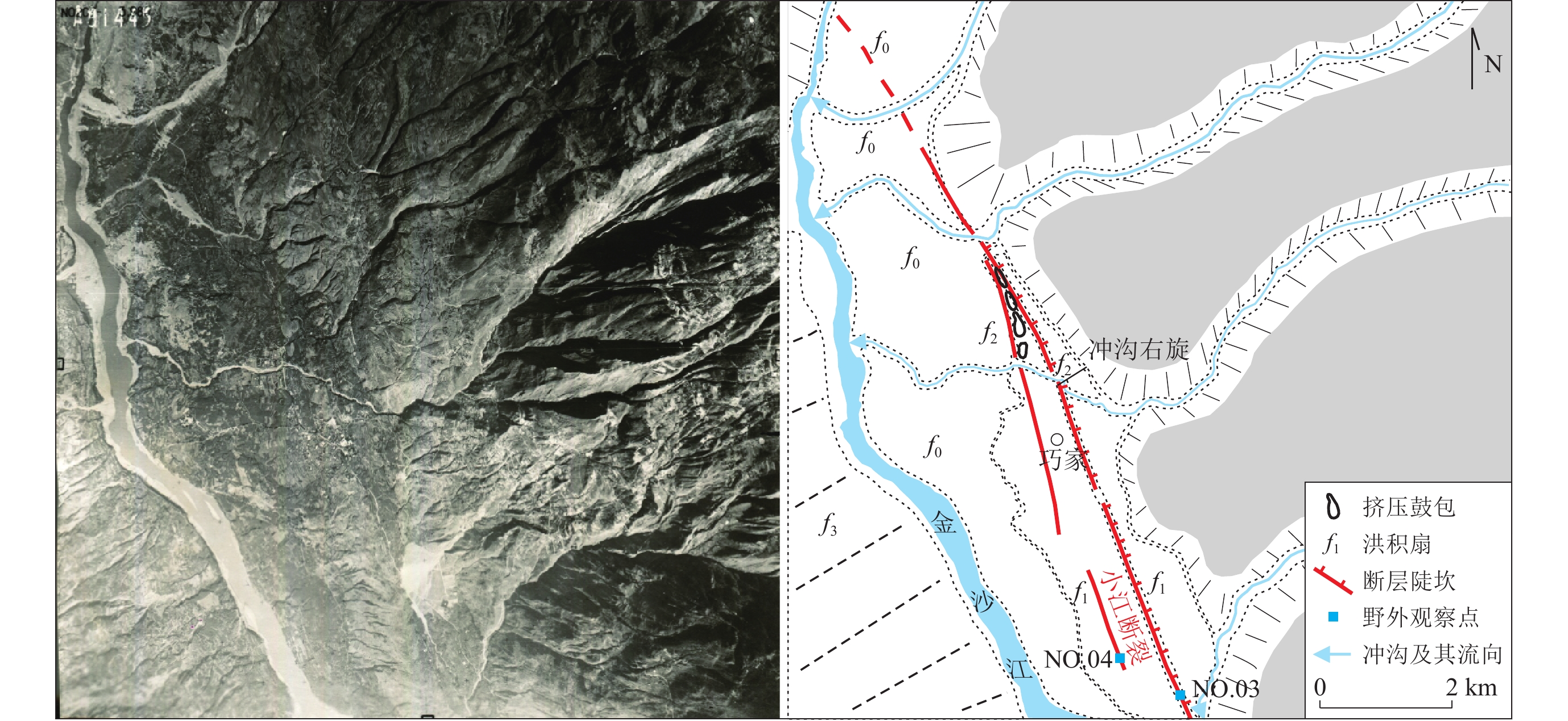
图 3 巧家县城附近航片及解译图
Figure 3. Aerial photographs and interpretation maps near Qiaojia County
![]()
图 4 宁南县西南侧则木河断裂地貌特征(a)及观察点1附近断层剖面(b−d)
Figure 4. Geomorphic characteristics (a) of the Zemuhe fault in southwest Ningnan County and fault cross-section near site 1 (b−d)
![]()
图 5 宁南县西南侧则木河断裂地貌特征(a)及观察点2断层剖面(b,c)
Figure 5. Geomorphology of the Zemuhe fault in southwest Ningnan County (a) and fault profile of site 2 (b,c)
![]()
图 6 巧家县城附近小江断裂地貌特征(a)及观察点3断层照片(b)
Figure 6. Geomorphic characteristics (a) and fault photos of site 3 (b) on the Xiaojiang fault near Qiaojia County
![]()
图 7 巧家县城附近观察点4处小江断裂分支断层照片
Figure 7. Branch fault photos of site4 on Xiaojiang fault near Qiaojia County
![]()
图 9 金沙江南岸大凉山断裂观察点6地貌特征(a)及断层剖面(b)
Figure 9. Geomorphic characteristics (a) and fault cross-section (b) of the Daliangshan fault on the south bank of the Jinsha River
![]()
图 10 1733年8月2日东川M7¾地震烈度图(国家地震局震害防御司,1995)
Figure 10. Seismic intensity map of the M7¾ Dongchuan earthquake on 2 August 1733 (Department of Seismic DamagePrevention,National Seismo-logical Bureau,1995)
-
国家地震局震害防御司. 1995. 中国历史强震目录[M]. 北京:地震出版社:1−514. Department of Seismic Damage Prevention,National Seismological Bureau. 1995. The Catalogue of Chinese Historical Earthquakes[M]. Beijing:Seismological Press:1−514 (in Chinese).
韩竹军,董绍鹏,毛泽斌,呼楠,谭锡斌,袁仁茂,郭鹏. 2017. 小江断裂带南段全新世活动的地质地貌证据与滑动速率[J]. 地震地质,39(1):1–19. Han Z J,Dong S P,Mao Z B,Hu N,Tan X B,Yuan R M,Guo P. 2017. The Holocene activity and strike-slip rate of the southern segment of Xiaojiang fault in the southeastern Yunnan region,China[J]. Seismology and Geology,39(1):1–19 (in Chinese).
何宏林,宋方敏,李传友. 1999. 四川则木河断裂带微断层地貌的地形测量和走滑速率的估算(英文)[J]. 地震地质,21(4):361–369. doi: 10.3969/j.issn.0253-4967.1999.04.010 He H L,Song F M,Li C Y. 1999. Topographic survey of micro faulted landform and estimation of strike slip rate for the Zemuhe fault,Sichuan Province[J]. Seismology and Geology,21(4):361–369.
何宏林,池田安隆,宋方敏,董兴权. 2002. 小江断裂带第四纪晚期左旋走滑速率及其构造意义(英文)[J]. 地震地质,24(1):14–26. doi: 10.3969/j.issn.0253-4967.2002.01.002 He H L,Ikeda Y,Song F M,Dong X Q. 2002. Late Quaternary slip rate of the Xiaojiang fault and its implication[J]. Seismology and Geology,24(1):14–26.
李姜一,周本刚,李铁明,杨永林,李正芳,龙锋. 2020. 安宁河—则木河断裂带和大凉山断裂带孕震深度研究及其地震危险性[J]. 地球物理学报,63(10):3669–3682. Li J Y,Zhou B G,Li T M,Yang Y L,Li Z F,Long F. 2020. Seismogenic depths of the Anninghe-Zemuhe and Daliangshan fault zones and their seismic hazards[J]. Chinese Journal of Geophysics,63(10):3669–3682 (in Chinese).
刘莉,张丽萍,李萍,杨鑫,邓清海. 2022. 金沙江巧家巨型古滑坡发育特征及其形成条件[J]. 人民长江,53(1):118–125. Liu L,Zhang L P,Li P,Yang X,Deng Q H. 2022. Development characteristics and forming conditions of Qiaojia giant ancient landslide in Jinsha River[J]. Yangtze River,53(1):118–125 (in Chinese).
任金卫,李玶. 1989. 则木河断裂带北段地震地貌及古地震研究[J]. 地震地质,11(1):27–34. Ren J W,Li P. 1989. Earthquake-caused landforms and paleoseismic study on the Northern segment of the Zemuhe fault[J]. Seismology and Geology,11(1):27–34 (in Chinese).
申旭辉,陈正位,许任德,张宁. 2000. 凉山活动构造带晚新生代变形特征与位移规模[J]. 地震地质,22(3):232–238. Shen X H,Chen Z W,Xu R D,Zhang N. 2000. Deformation characteristics and displacement amount of the Liangshan active fault zone in Late Cenozoic Era[J]. Seismology and Geology,22(3):232–238 (in Chinese).
宋方敏,汪一鹏,俞维贤,曹忠权,申旭辉,沈军. 1998. 小江活动断裂带[M]. 北京:地震出版社:1−237. Song F M,Wang Y P,Yu W X,Cao Z Q,Shen X H,Shen J. 1998. Xiaojiang Active Fault Zone[M]. Beijing:Seismological Press:1−237 (in Chinese).
唐荣昌,韩渭滨. 1993. 四川活动断裂与地震[M]. 北京:地震出版社:1−368. Tang R C,Han W B. 1993. Active Fault and Earthquake in Sichuan Province[M]. Beijing:Seismological Press:1−368 (in Chinese).
魏占玉,何宏林,石峰,徐岳仁,毕丽思,孙浩越. 2012. 大凉山断裂带南段滑动速率估计[J]. 地震地质,34(2):282–293. Wei Z Y,He H L,Shi F,Xu Y R,Bi L S,Sun H Y. 2012. Slip rate on the South segment of Daliangshan fault zone[J]. Seismology and Geology,34(2):282–293 (in Chinese).
闻学泽. 1983. 则木河断裂的第四纪构造活动模式[J]. 地震研究,6(1):41–50. Wen X Z. 1983. Model of active tectonic of the Quaternary period of Zemu river fault[J]. Journal of Seismological Research,6(1):41–50 (in Chinese).
闻学泽. 2000. 四川西部鲜水河—安宁河—则木河断裂带的地震破裂分段特征[J]. 地震地质,22(3):239–249. Wen X Z. 2000. Character of rupture segmentation of the Xianshuihe-Anninghe-Zemuhe fault zone,Western Sichuan[J]. Seismology and Geology,22(3):239–249 (in Chinese).
周荣军,黎小刚,黄祖智,何玉林,戈天勇. 2003. 四川大凉山断裂带的晚第四纪平均滑动速率[J]. 地震研究,26(2):191–196. Zhou R J,Li X G,Huang Z Z,He Y L,Ge T Y. 2003. Average slip rate of Daliang mountain fault zone in Sichuan in Late Quaternary period[J]. Journal of Seismological Research,26(2):191–196 (in Chinese).
Allen C R,Luo Z L,Qian H,Wen X Z,Zhou H W,Huang W S. 1991. Field study of a highly active fault zone:The Xianshuihe fault of southwestern China[J]. GSA Bull,103(9):1178–1199. doi: 10.1130/0016-7606(1991)103<1178:FSOAHA>2.3.CO;2
Andrews D J. 1994. Fault geometry and earthquake mechanics[J]. Ann Geophys,37(6):1341–1348.
Bai M K,Chevalier M L,Pan J W,Replumaz A,Leloup P H,Métois M,Li H B. 2018. Southeastward increase of the Late Quaternary slip-rate of the Xianshuihe fault,eastern Tibet. Geodynamic and seismic hazard implications[J]. Earth Planet Sci Lett,485:19–31.
Duman T Y, Emre Ö. 2013. The East Anatolian Fault: Geometry, segmentation and jog characteristics[J]. Geo Soc London Special Pub,372(1):495–529. doi: 10.1144/SP372.14
Hamling I J,Hreinsdóttir S,Clark K,Elliott J,Liang C R,Fielding E,Litchfield N,Villamor P,Wallace L,Wright T J,D'Anastasio E,Bannister S,Burbidge D,Denys P,Gentle P,Howarth J,Mueller C,Palmer N,Pearson C,Power W,Barnes P,Barrell D J A,Van Dissen R,Langridge R,Little T,Nicol A,Pettinga J,Rowland J,Stirling M. 2017. Complex multifault rupture during the 2016 MW7.8 Kaikōura earthquake,New Zealand[J]. Science,356(6334):eaam7194. doi: 10.1126/science.aam7194
Harris R A,Day S M. 1993. Dynamics of fault interaction:Parallel strike-slip faults[J]. J Geophys Res:Solid Earth,98(B3):4461–4472. doi: 10.1029/92JB02272
He H L,Ikeda Y,He Y L,Togo M,Chen J,Chen C Y,Tajikara M,Echigo T,Okada S. 2008. Newly-generated Daliangshan fault zone:Shortcutting on the central section of Xianshuihe−Xiaojiang fault system[J]. Science China:Earth Sciences,51(9):1248–1258. doi: 10.1007/s11430-008-0094-4
Jia Z,Jin Z Y,Marchandon M,Ulrich T,Gabriel A A,Fan W Y,Shearer P,Zou X Y,Rekoske J,Bulut F,Garagon A,Fialko Y. 2023. The complex dynamics of the 2023 Kahramanmaraş,Turkey,MW7.8−7.7 earthquake doublet[J]. Science,381(6661):985–990.
Loveless J P,Meade B J. 2011. Partitioning of localized and diffuse deformation in the Tibetan Plateau from joint inversions of geologic and geodetic observations[J]. Earth Planet Sci Lett,303(1/2):11–24.
Nielsen S B,Knopoff L. 1998. The equivalent strength of geometrical barriers to earthquakes[J]. J Geophys Res:Solid Earth,103(B5):9953–9965. doi: 10.1029/97JB03293
Shao Y X,Liu-Zeng J,Oskin M E,Elliott A J,Wang P,Zhang J Y,Yuan Z D,Li Z F. 2018. Paleoseismic investigation of the Aksay restraining double bend,Altyn Tagh fault,and its implication for barrier-breaching ruptures[J]. J Geophys Res:Solid Earth,123(5):4307–4330.
Shen Z K,Lü J N,Wang M,Bürgmann R. 2005. Contemporary crustal deformation around the southeast borderland of the Tibetan Plateau[J]. J Geophys Res:Solid Earth,110(B11):B11409.
Sieh K,Jones L,Hauksson E,Hudnut K,Eberhart-Phillips D,Heaton T,Hough S,Hutton K,Kanamori H,Lilje A,Lindvall S,McGill S F,Mori J,Rubin C,Spotila J A,Stock J,Thio H K,Treiman J,Wernicke B,Zachariasen J. 1993. Near-field investigations of the Landers earthquake sequence,April to July 1992[J]. Science,260(5105):171–176. doi: 10.1126/science.260.5105.171
Sun H Y,He H L,Ikeda Y,Wei Z Y,Chen C Y,Xu Y R,Shi F,Bi L S,Shirahama Y,Okada S,Echigo T. 2019. Paleoearthquake history along the southern segment of the Daliangshan fault zone in the southeastern Tibetan Plateau[J]. Tectonics,38(7):2208–2231.
Tapponnier P,Molnar P. 1977. Active faulting and tectonics in China[J]. J Geophys Res,82(20):2905–2930. doi: 10.1029/JB082i020p02905
Wang E,Burchfiel B C,Royden L H,Chen L Z,Chen J S,Li W X,Chen Z L. 1998. Late Cenozoic Xianshuihe-Xiaojiang,Red River,and Dali Fault Systems of Southwestern Sichuan and Central Yunnan,China[M]. Boulder:Geological Society of America:1−108.
Wang E,Burchfiel B C. 2000. Late Cenozoic to Holocene deformation in southwestern Sichuan and adjacent Yunnan,China,and its role in formation of the southeastern part of the Tibetan Plateau[J]. GSA Bull,112(3):413–423. doi: 10.1130/0016-7606(2000)112<413:LCTHDI>2.0.CO;2
-
期刊类型引用(4)
1. 赵一帆,王毅. 基于三重震相波形模拟的东北亚地区上地幔S波速度结构研究. 物探化探计算技术. 2024(02): 137-145 .  百度学术
百度学术
2. 苏慧,魏荣强,周元泽,崔清辉,李国辉. 东北亚边缘地区地幔过渡带内滞留太平洋板片上界面的三重震相研究. 地球物理学报. 2023(06): 2431-2444 . 百度学术
3. 崔辉辉,周元泽,石耀霖,王晓冉,李国辉. 华北克拉通东部滞留板块下方低速异常的地震三重震相探测. 地球物理学报. 2016(04): 1309-1320 . 百度学术
4. 李国辉,眭怡,周元泽. 基于P波三重震相的下扬子克拉通地幔转换带顶部低速层初探. 地球物理学报. 2014(07): 2362-2371 . 百度学术
其他类型引用(11)


 下载:
下载:


计量
- 文章访问数: 118
- HTML全文浏览量: 48
- PDF下载量: 48
- 被引次数: 15
