

Analysis of earthquake sequence and seismogenic structure of the 2023 MS6.2 Jishishan earthquake,Gansu Province,China
-
摘要:
2023年12月18日23时59分,甘肃省临夏州积石山县发生了MS6.2强震,震中位于柴达木—祁连地块东北缘拉脊山断裂系南段。本文基于地震重新定位与震源机制和应力反演结果对此次地震的发震构造进行了分析,并对区域危险性进行了初步探讨。采用甘肃和青海地震台网的观测数据,利用双差定位方法对震后10天的地震序列进行重定位,共获得605个高精度定位结果,结果显示主震震中位置为(35.748°N,102.812°E),震源深度为16.4 km。余震序列主要分布在6—15 km深度处,水平分布上,在震源区域内呈长轴沿NW−SE向展布,逐渐向北转变为近NS向展布,深度剖面显示出断层倾向为NE向。应用FocMech-Flow自动化流程反演震源机制解,获得MS6.2主震的最佳双力偶解,节面Ⅰ走向302°、倾角58°、滑动角45°;节面Ⅱ走向 184°、倾角53°、滑动角138°。其中,节面Ⅰ走向与震源区附近余震展布方向一致,可判定其为发震断层面。应力场反演结果表明震源区应力性质主要为逆冲型,最大主应力轴为WSW−ENE向。结合区域重力异常和已有地质资料,判断此次地震的发震断层为积石山东缘断裂系中的一条较深的反冲断层,并将其命名为“大河家断裂”。现有历史地震资料表明,近二十年来柴达木—祁连地块发生的强震具有向东迁移的趋势,此次地震的发生,暗示出位于积石山东部的西秦岭北缘断裂带未来的强震危险性有所增加。
Abstract:On December 18th, 2023 at 23:59, an earthquake of MS6.2 occurred in Jishishan County, Linxia Prefecture, Gansu Province, with the epicenter located near the southern segment of the Lajishan fault system in the northeastern Qaidam-Qilian block. In this paper, we conducted the relocation, focal mechanism and stress inversion results to analyze the seismic structure and regional seismic risk. Using digital waveform data from the seismic networks of Gansu and Qinghai Provinces, the double-difference location algorithm was conducted on the earthquake sequence within 10 days after the earthquake.
A total of 605 high-precision relocated earthquakes were revealed and the epicenter of the mainshock was determined to be at (35.748°E, 102.812°N), with a depth of 16.4 km. Most aftershocks located at depths of 6−15 km spreading along NW-SE direction near the mainshock epicenter, while some aftershocks gradually shift to a near NS direction to the north. Depth profile of aftershocks further suggests that the seismogenic fault plane dips to NE. By applying the FocMech-Flow automatic inversion of focal mechanism, the best double-couple solution for the MS6.2 mainshock was obtained. The parameters of two nodal planes are as follows: strike 302°, dip 58°, rake 45° for nodal plane I and strike 184°, dip 53°, rake 138° for nodal plane Ⅱ. Consistent with the direction of aftershock distribution near the mainshock, the plane Ⅰ is considered as the fault plane responsible for this earthquake. Stress field inversion results indicated that the stress in the epicenter belongs to thrust-type and the azimuth of σ1 axis orients WSW-ENE. Combining regional gravity anomaly and previous geological data, we suggest that the seismogenic fault is a deeply buried back thrust fault in the east Jishishan fault system and named it as “Dahejia fault”. Historical earthquake records in the Qaidam-Qilian block show that the strong earthquakes gradually migrate eastward in recent two decades. This earthquake further enhances the seismic hazards of the western Qinling fault to the east of Jishishan.
-
引言
据中国地震台网测定,北京时间2023年12月18日23点59分在甘肃省积石山县发生MS 6.2地震,震中位于(35.70°N,102.79°E ),震源深度为10 km。此次地震震中距离积石山县城仅8 km,距离兰州市102 km,人口相对密集。青海省循化县、民和县(青海省地震局,2023)、甘肃省兰州市、定西市、武威市、金昌市、庆阳市、平凉市、天水市、陇南市等地震感明显(甘肃省地震局,2023)。地震发生后,甘肃省抗震救灾指挥部于12月20日召开新闻发布会通报,截至当日9时,积石山地震共造成131人死亡,980人受伤,16人失联,此次地震是2023年我国人员伤亡最为严重的地震。
此次积石山MS6.2地震发生在柴达木—祁连地块东北缘,拉脊山断裂系南段附近(图1),是继2001年昆仑山口西MS8.1地震(Li et al,2005;Xu et al,2006),2016年门源MS6.4地震(胡朝忠等,2016),2021年玛多MS7.4地震(Pan et al,2022;Ren et al,2022)和2022年门源MS6.9地震(Li et al,2023a)之后,在柴达木—祁连地块内部发生的一次最大地震。距今约
3700 —3136 年,此次地震震中区域曾发生过至少两次强烈的古地震事件,造成的地震灾害直接导致了齐家文化的毁灭(李智敏等,2014),表明区域内具备发生强震的可能。郭祥云等(2024)的震源机制解结果显示,此次地震以逆冲机制为主,两个断层节面分别为:节面Ⅰ走向301°—307°、倾角50°—58°,滑动角57°—70°,节面Ⅱ走向156°—164°、倾角42°—47°、滑动角112°—127°。然而,由于震源区地质构造复杂,对余震的精细分布和断层的空间展布认识尚不清晰,无法准确判断发震断裂,从而限制了对此次地震发震构造及动力学机制的认识。![]() 图 1 积石山MS6.2地震区域主要断裂和历史地震分布图(a) 柴达木—祁连地块主要活动断裂及历史地震分布图;(b) 震中区主要活动断裂及历史地震分布图(块体主要活动断裂及历史地震分布引自文献Tapponnier 等 (2001),Yuan 等 (2013),徐锡伟等 (2014),Li 等(2023a)GPS矢量引自Wang和Shen (2020);烈度圈(等震线)引自甘肃省地震局(2023)Figure 1. Maps showing the major active faults and epicenters of historical earthquakes in the regional area of Jishishan MS6.2 earthquake(a) Map showing major active faults in epicenters of historical earthuqakes in Qaidam-Qilian block;(b) Map showing the active faults and epicenters of historic earthquakes in the region of Jishishan MS6.2 earthquakeFault trace is based on the map (Tapponnier et al,2001;Yuan et al,2013; Xu et al,2014;Li et al,2023a);GPS vectors are from Wang and Shen (2020);Isoseismal map from Gansu Earthquake Agency (2023)
图 1 积石山MS6.2地震区域主要断裂和历史地震分布图(a) 柴达木—祁连地块主要活动断裂及历史地震分布图;(b) 震中区主要活动断裂及历史地震分布图(块体主要活动断裂及历史地震分布引自文献Tapponnier 等 (2001),Yuan 等 (2013),徐锡伟等 (2014),Li 等(2023a)GPS矢量引自Wang和Shen (2020);烈度圈(等震线)引自甘肃省地震局(2023)Figure 1. Maps showing the major active faults and epicenters of historical earthquakes in the regional area of Jishishan MS6.2 earthquake(a) Map showing major active faults in epicenters of historical earthuqakes in Qaidam-Qilian block;(b) Map showing the active faults and epicenters of historic earthquakes in the region of Jishishan MS6.2 earthquakeFault trace is based on the map (Tapponnier et al,2001;Yuan et al,2013; Xu et al,2014;Li et al,2023a);GPS vectors are from Wang and Shen (2020);Isoseismal map from Gansu Earthquake Agency (2023)对地震序列进行重定位和反演震源机制解是理解区域地震活动特征、确定发震断裂以及认识断层空间展布特征的重要手段(Waldhauser,Ellsworth,2000;房立华等,2014;鲁人齐等,2022;蔡妍等,2023)。因此,本文基于甘肃和青海地震台网的观测数据,利用双差定位方法(Waldhauser,Ellsworth,2000;房立华等,2018)对积石山MS6.2地震震后10天的地震序列进行重定位,应用FocMech-Flow流程(Li et al,2023b)对主震以及M>2.0的余震序列进行自动化震源机制解反演。最后,本文结合区域重力异常、历史地震和地质资料等,对此次积石山地震的发震断层和空间展布特征进行分析,以期探讨出此次发震构造的动力学背景,为区域内未来强震活动性的评估提供科学依据。
1. 区域活动构造背景
柴达木—祁连地块位于青藏高原东北缘,表现为挤压环境下的盆−山构造特征,是高原北部构造变形和强震频发的地区(李海兵等,2021),地块边界的活动断裂主要由ENE−EW走向的左旋走滑的东昆仑断裂带、阿尔金断裂带和海原断裂带以及WNW走向的逆冲的祁连山断裂带组成(图1a,郑文俊等,2016),地块内部主要活动断裂为NW走向的日月山断裂和向NE凸出、呈弧形展布的拉脊山断裂带(图1,袁道阳等,2005)。该区域的地震活动十分强烈,自有历史记载以来,发生在柴达木—祁连活动地块边界带内的M≥7强震达20次,其中M≥8的大地震已达4次,包括1654年天水M8地震、1920年海原M8½地震、1927年古浪M8.0地震和2001年昆仑山口西MS8.1地震(图1a)。
拉脊山断裂带是柴达木—祁连地块东部一条重要的逆冲型活动断裂,是介于NNW向的日月山右旋走滑断裂带和WNW向的西秦岭北缘左旋走滑断裂带之间的一个大型挤压构造带(袁道阳等,2005)。在几何展布上,拉脊山断裂带可分为南、北两段,北段约形成于22 Ma (Yuan et al,2013)由近EW向展布的、左旋兼逆冲性质的拉脊山北缘断裂和拉脊山南缘断裂组成。南段约形成于13 Ma (Lease et al,2011)由近NW走向的、以逆冲为主的积石山东缘断裂和积石山西缘断裂组成。积石山西缘断裂走向NW,倾向NE,全长约45 km,为一条逆冲断裂,线性地貌明显,在积石山西侧表现为将加里东期花岗岩向西逆冲到新近系之上(图2);积石山东缘断裂总体走向NNW,倾向SW,长约40 km,向北延伸与拉脊山北缘断裂斜交,向南则与倒淌河—临夏断裂相连(图1b),断裂运动以逆冲为主,构成了积石山隆起与盆地的分界线,在积石山县西侧可见加里东期花岗闪长岩逆冲到新近系之上(图2)(张波,2012)。此次积石山MS6.2地震震中位于积石山东缘断裂附近(图1b)。
![]() 图 2 积石山MS6.2地震震中区域活动断层分布图地层分布根据青海省地质矿产局(1991)绘制,区域断层数据由桂林理工大学陈立春提供,图中红色断层为本文推测的发震断层,基于遥感解译和野外调查确定Figure 2. Maps showing the detailed active faults in the regional area of Jishishan MS6.2 earthquakeStratigraphic distribution based on the map Qinghai Bureau of Geology and Mineral Resources (1991),fault traces provided by the Professor Chen Lichun from Guilin University of Technology,the red fault in the figure is the conjectural seismogenic faults determined by interpretation of remote sensing images and geological surveying
图 2 积石山MS6.2地震震中区域活动断层分布图地层分布根据青海省地质矿产局(1991)绘制,区域断层数据由桂林理工大学陈立春提供,图中红色断层为本文推测的发震断层,基于遥感解译和野外调查确定Figure 2. Maps showing the detailed active faults in the regional area of Jishishan MS6.2 earthquakeStratigraphic distribution based on the map Qinghai Bureau of Geology and Mineral Resources (1991),fault traces provided by the Professor Chen Lichun from Guilin University of Technology,the red fault in the figure is the conjectural seismogenic faults determined by interpretation of remote sensing images and geological surveying在积石山东缘断裂西侧,分布有几条较小规模的分支断裂,自西向东依次为:锁同断裂、牙儿咱断裂、扎几楞断裂、协拉断裂及位于大河家盆地内部东倾的逆冲断裂,这些分支断裂自NW向SE逐渐收敛至积石山东缘断裂的主断裂带上(图2)。由于第四系覆盖严重,积石山东缘断裂在震中区域的展布特征并不清晰。据地震历史资料显示,拉脊山周缘地区共发生过20余次M5左右的破坏性地震(袁道阳等,2005),但积石山东缘断裂带附近未见历史强震记录。已有的古地震研究显示,大河家盆地的北侧区域在距今
3700 年至3136 年之间,曾发生过两次强震事件,晚第四纪以来发震断裂的垂直活动速率约为0.5 mm/a (李智敏等,2014),大地测量结果则揭示出积石山东缘断裂带现今的垂向活动速率为(1.1±0.2) mm/a (Zhuang et al,2023)。2. 余震精定位结果
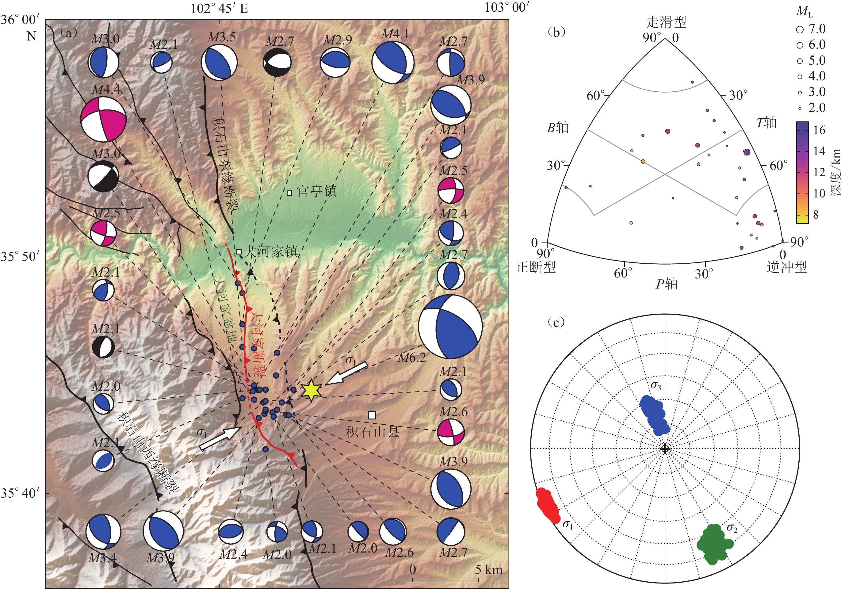
截至2023年12月27日6时,甘肃地震台网给出的地震目录中包含了823次余震,震级范围分布在ML−0.7—4.1。使用震中距30 km以内的32个地震台站的数据,其中震中距10 km以内有6个地震台,最近台站的震中距约3.2 km。采用Hypo2000测定主震位置,主震位于(35.748°N,102.812°E ),震源深度16.4 km,水平误差0.73 km,垂直误差0.95 km。采用双差定位方法(Waldhauser,Ellsworth,2000)对震后10天内余震序列进行重新定位,首先根据初始震源位置组成地震对,然后选择相邻较近、到达同一台站的一组震相的走时差来反演震源位置,可较好地消除震源至台站间共同传播路径效应的影响,在国内地震序列特征分析研究中得到了广泛应用(Fang et al,2015;房立华等,2018;易桂喜等,2019;Yang et al,2023; Zhang et al,2023)。本研究采用的一维速度模型分为4层,顶界面深度分别为0,23.1,46.0,56.0 km。P波速度值分别为6.1,6.3,7.0,8.3 km/s。图3a为使用双差定位方法获得的重定位结果,共获得605次地震的位置参数,东西、南北和垂直方向的平均定位误差分别为0.071,0.083,0.138 km。从平面图上看,重新定位后的余震在震中附近主要沿NW向分布,向北逐渐变为近NS向分布(图3a),总长约15 km,且主要集中在南段,北段的余震数量较少。重定位后的震源深度显示,余震主要位于6—15 km深度(图3b),而主震位于整个地震序列的底部。沿BB′方向,余震序列表现为向NE方向倾斜的分布特征(图3c)。
![]() 图 3 余震序列重定位结果分布图(a) 余震震中位置及断层分布图;(b−c) 震源沿AA’和BB’剖面的深度分布图,黄色阴影区为余震集中分布深度,红色条带为拟合的发震断层面Figure 3. Relocation results of the aftershock sequence(a) Distribution of the aftershock epicenters and regional faults;(b−c) Distribution of focal depth along profile AA’ and BB’,yellow shaded area represent the depth of most aftershocks,while the red shaded area shows the fit line of the fault plane
图 3 余震序列重定位结果分布图(a) 余震震中位置及断层分布图;(b−c) 震源沿AA’和BB’剖面的深度分布图,黄色阴影区为余震集中分布深度,红色条带为拟合的发震断层面Figure 3. Relocation results of the aftershock sequence(a) Distribution of the aftershock epicenters and regional faults;(b−c) Distribution of focal depth along profile AA’ and BB’,yellow shaded area represent the depth of most aftershocks,while the red shaded area shows the fit line of the fault plane3. 震源机制解与应力反演
为进一步确定发震断层及区域应力场的状态,本文使用甘肃省地震局提供的2023年12月18日—12月21日共41个地震事件波形数据和观测报告,应用FocMech-Flow流程(Li et al,2023b)自动化反演震源机制,获得了M2.0—6.2共31个地震事件的震源机制解(图4a)。该流程主要包含三个环节:数据预处理、DiTingMotion判别P波初动极性以及利用格点尝试法(俞春泉等,2009)反演震源机制解。首先根据观测报告筛选出可用于反演震源机制解的地震事件;其次,根据到时信息截取地震波形,并输入DiTingMotion判别P波初动极性;最后,组合P波初动极性和地震事件信息,反演获得震源机制解。其中,主震MS6.2节面Ⅰ走向302°、倾角58°、滑动角45°,节面Ⅱ走向 184°、倾角53°、滑动角138° (图4a)。
![]() 图 4 2023年积石山MS6.2主震和12月18—21日M≥2.0余震的震源机制解(a) 震源机制解空间分布,断层性质与图3a一致;(b) 震源机制分类三角图;(c) 应力场反演结果震源机制类型:蓝色代表逆冲型,紫红色为走滑型,黑色为正断型Figure 4. Focal mechanism solutions of the Jishishan MS6.2 main shock and M≥2.0 after shocks during 18−21 December 2023(a) Distribution of focal mechanism solutions,the fault type is consistent with fig.3a;(b) Triangular diagram of focal mechanism types;(c) Stress field inversion results. Focal mechanisms:Blue represents thrust type, purple represents strike-slip type,black represents normal type
图 4 2023年积石山MS6.2主震和12月18—21日M≥2.0余震的震源机制解(a) 震源机制解空间分布,断层性质与图3a一致;(b) 震源机制分类三角图;(c) 应力场反演结果震源机制类型:蓝色代表逆冲型,紫红色为走滑型,黑色为正断型Figure 4. Focal mechanism solutions of the Jishishan MS6.2 main shock and M≥2.0 after shocks during 18−21 December 2023(a) Distribution of focal mechanism solutions,the fault type is consistent with fig.3a;(b) Triangular diagram of focal mechanism types;(c) Stress field inversion results. Focal mechanisms:Blue represents thrust type, purple represents strike-slip type,black represents normal type参照俞春泉等(2009)评价标准,所获得的31个地震事件震源机制A类12个,B类13个,C类6个。根据震源机制解三个应力轴倾角的大小,使用FMC程序(Álvarez-Gómez,2019)对震源机制进行分类。结果显示,积石山地震序列地震事件的震源机制以逆冲型为主,占总体震源机制的90%以上(图4b)。
采用Vavryčuk (2014)提出的线性迭代联合反演法,分析积石山MS6.2地震应力场,结果显示,此次地震周边整体区域应力场呈WSW−ENE向挤压。σ1方位角约244°,倾角约4°,倾角较低;σ2方位角约153°,倾角约23°,中低角度倾斜;σ3方位角约343°,倾角约67° (图4c,表1)。研究结果说明应力场类型为逆冲型应力场,发震区域整体应力场处于挤压状态(图4a)。
表 1 震区应力场反演结果表Table 1. Stress field inversion results in Jishishan area应力 方位角/° 倾角/° σ1 244.30±6.86 3.67 σ2 152.77±12.26 22.63 σ3 343.01±11.95 67.04 4. 重力异常分析
由于震源区断裂结构复杂,且缺少精细的活动断裂基础调查工作。本文收集并分析了中国地质调查局平均测点间距为5—10 km的布格重力异常数据,以刻画断裂带结构和几何形态(Liu,2021;石磊等,2022;Wang et al,2022b),为发震构造和区域地震危险性研究提供相关参考。此次地震主震和余震深度都分布在30 km以浅区域(图3b),因此首先对布格重力异常进行优化滤波(Guo et al,2013)去除深部(>30 km)异常,获得震源区剩余异常(图5a)。然后对剩余异常进行频率域换算(Mickus,Hinojosa,2001),得到全张量梯度。重力张量的最小和最大特征向量(Beiki,2013)可分别表示断裂带的走向和倾角(图5)。
![]() 图 5 研究区布格重力异常∆G (a)和断裂倾角β图(b)Figure 5. Bouguer gravity anomalies ∆G (a) and dip angle β distribution map (b) of the study area
图 5 研究区布格重力异常∆G (a)和断裂倾角β图(b)Figure 5. Bouguer gravity anomalies ∆G (a) and dip angle β distribution map (b) of the study area重力全张量梯度矩阵${\boldsymbol{ \varGamma}} $可分解为三个矩阵:
$$ {\boldsymbol{ \varGamma}} {=}\left[ {\begin{array}{*{20}{c}} {{g_{xx}}}&{{g_{xy}}}&{{g_{x{\textit{z}}}}} \\ {{g_{yx}}}&{{g_{yy}}}&{{g_{y{\textit{z}}}}} \\ {{g_{zx}}}&{{g_{zy}}}&{{g_{{\textit{z}}{\textit{z}}}}} \end{array}} \right] = {{{\boldsymbol{US}}}}{{{{\boldsymbol{V}}}}^{\rm T}} \text{,} $$ (1) 式中,$ {g_{\textit{z}}} $是在$ ( x\text{,} y ) $水平面上测量的,U是一个正交矩阵,$ {\boldsymbol{S }=}\left[ {\begin{array}{*{20}{c}} {{\lambda _1}}&0&0 \\ 0&{{\lambda _2}}&0 \\ 0&0&{{\lambda _3}} \end{array}} \right] $包含三个正的特征值($ {\lambda _1} {\text{≥}} {\lambda _2} {\text{≥}} {\lambda _3} $),$ {\boldsymbol{V }=} [ {{{\boldsymbol{V}}_1}\,\,{{\boldsymbol{V}}_2}\,\,{{\boldsymbol{V}}_3}} ] $包含三个特征向量。张量的最小和最大特征向量可分别表示断裂带的走向和倾角。其中,倾角$ \beta $由最大特征向量$ {{\boldsymbol{V}}_1} $的三个分量$ {\nu _{1{{x}}}}\text{,} {\nu _{1{{y}}}}\text{,} {\nu _{1{\textit{z}}}} $定义为(Beiki,2013):
$$ \beta {=}{\tan ^{ - 1}}\left( {\frac{{{\nu _{1{\textit{z}}}}}}{{\sqrt {\nu _{1x}^2 + \nu _{1y}^2} }}} \right) \text{,} $$ (2) 由此可对断裂带的倾角进行定量估计,且分析$ \beta $沿断裂带的分布常用来评估断层类型(Beiki,2013; Matsumoto et al,2016)。
剩余重力异常图较好地呈现了西秦岭北缘断裂带,但其位置与地表分布存在差异,重力异常划分出的断裂位置位于地表调查位置的北侧。断裂带以南主要表现为负异常,断裂带以北产生明显变化,相对异常转变为正值,且达到正的最大值(0.15 mm/s2,图5a),与断裂带所在的地块边界上断裂属性相对应。积石山东缘断裂带同样位于异常变化梯级带附近,但与西秦岭北缘断裂带相比,断裂两侧异常值变化较为平缓,表明此次地震震中南北两侧断裂是连续展布的。
重力全张量梯度估计得到的断层倾角为壳内平均值(石磊等,2022)。前人数值模拟研究显示,正断层两侧倾角随深度变化而减小,逆断层两侧倾角随深度变化而增加,走滑断层两侧倾角一般没有明显的变化(Beiki,Pedersen,2010;Beiki,2013;Kusumoto,2015)。由图5b可以看出,西秦岭北缘断裂带两侧倾角没有明显的变化,主要表现为走滑性质。积石山东缘断裂带倾角由西侧的50°—60°增加为70°—80°,表现为明显的逆冲性质。
5. 讨论
5.1 发震构造及三维模型
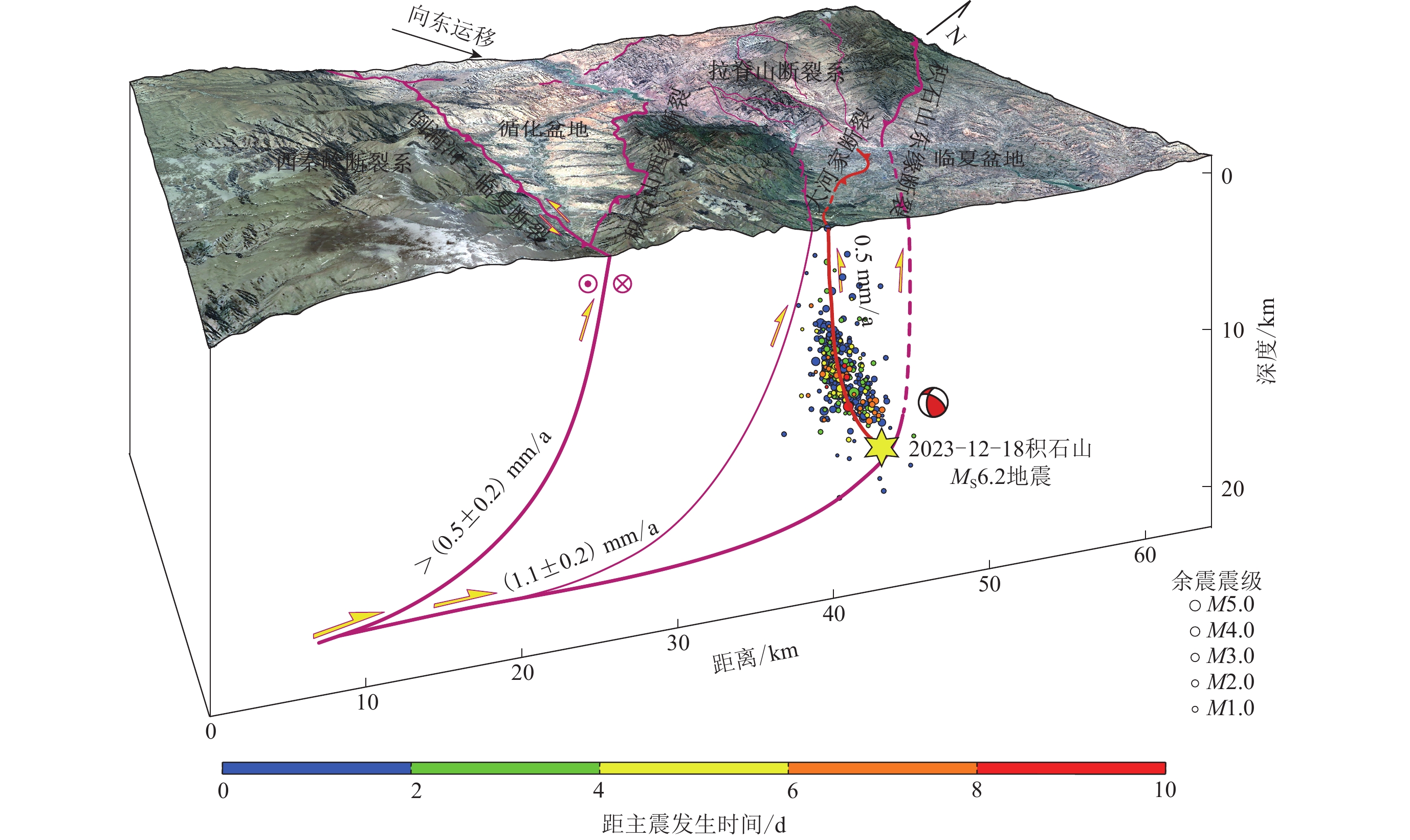
地震在空间上的分布可直观地反映出发震断层的形态及破裂范围(房立华等,2013;蔡妍等,2023)。由震后十天的余震分布可以看出,在水平方向上,余震由近震中的NW向展布向北逐渐转变为近NS向展布(图3a);在深度剖面上,余震主要分布深度为6—15 km,且主要发生在主震上方(图3b),总体上余震揭示的断层面倾向NE,倾角近62° (图3c)。本文通过震源机制解,得到主震的节面Ⅰ走向302°、倾角58°、滑动角45°,节面Ⅱ走向 184°、倾角53°、滑动角138° (图4a),其中节面Ⅱ倾向W,这与余震深度剖面揭示的断层倾向明显相反(图3c),由此可以认为,余震的空间展布与断层面解的节面Ⅰ基本一致。已有地质资料表明,震中位于积石山东缘断裂带东侧(图2),该断裂倾向W,倾角60° (Lease et al,2012),这与本文确定的余震分布和震源机制解显示的断层面特征并不一致。本文通过震后野外调查,结合李智敏等(2014)对震区的遥感解译结果,认为大河家盆地东部至南部出露一条逆冲活动断层,该断层南段产状为:走向330°、倾向NE、倾角70°,北段产状为:走向350°、倾向ENE、倾角80°,擦痕指示为逆冲兼左旋走滑特征(图6),该断层的走向、倾向和余震所揭示的断层面产状较为一致(图3a,4a),且余震沿该断层连续、密集分布,因此,可判定为此次地震的发震断裂。该断裂自大河家镇起,呈近NS向展布,在大河家盆地南缘转变为走向NW,总长约15 km,本文将其命名为“大河家断裂”(图2,3a,4a)。
![]() 图 6 大河家断裂野外特征照片(照片位置见图2)大河家断裂南(a)、北(c)段断层野外照片和大河家断裂断层面擦痕(b,d)指示了逆冲兼左旋滑的运动特征。图(a−b)位置由中国地震局地质研究所郭鹏提供,图(c−d)由青海省地震局李智敏提供Figure 6. Field photos of Dahejia fault (location in fig.2)Figs.(a,c) are field photos of Dahejia fault in the southern and northern section;Figs.(b,d) are lineation on the fault plane show-ing the thrust with left-lateral slip component of Dahejia fault. Location of Figs.(a−b) are provided by Guo Peng from the Institute of Geology,China Earthquake Administration; Figs.(c−d) are provided by Li Zhimin from Qinghai Earthquake Agency
图 6 大河家断裂野外特征照片(照片位置见图2)大河家断裂南(a)、北(c)段断层野外照片和大河家断裂断层面擦痕(b,d)指示了逆冲兼左旋滑的运动特征。图(a−b)位置由中国地震局地质研究所郭鹏提供,图(c−d)由青海省地震局李智敏提供Figure 6. Field photos of Dahejia fault (location in fig.2)Figs.(a,c) are field photos of Dahejia fault in the southern and northern section;Figs.(b,d) are lineation on the fault plane show-ing the thrust with left-lateral slip component of Dahejia fault. Location of Figs.(a−b) are provided by Guo Peng from the Institute of Geology,China Earthquake Administration; Figs.(c−d) are provided by Li Zhimin from Qinghai Earthquake Agency另一方面,本文的重力异常结果显示积石山主断裂带在震中区域连续展布(图5a),并未出现明显阶区,而积石山主断裂带应位于震中东侧(图2a,3a,4a)。此次地震震中位于右旋走滑的日月山断裂和左旋走滑的西秦岭北缘断裂形成的挤压构造带(图2b,袁道阳等,2005),该类区域应力较易聚集,是典型的孕震构造区域(Lozos et al,2011),在WSW−ENE向挤压应力下(图4a,4c,袁道阳等,2005),可能因局部地壳介质的力学强度存在差异(蔡妍等,2023),大河家断裂带作为积石山东缘断裂系的一条反冲断裂(图6)产生了破裂滑动。在大地构造尺度上,西秦岭北缘断裂带宝鸡—锅麻滩地区晚第四纪以来的左旋走滑速率约为2.1—2.9 mm/a (图7,李传友等,2007;Chen,Lin,2019),向西延伸至尾端,近1 mm/a的速率被小规模的走滑断裂所吸收(Hao et al,2021),近1.6 mm/a的速率则被积石山垂向活动所吸收(Zhuang et al,2023)。大地测量结果显示,现今积石山西缘断裂带垂向活动速率约为(0.5±0.2) mm/a,东缘断裂带则为(1.1±0.2) mm/a,其中约0.5 mm/a的垂向速率又被大河家断裂所吸收(图6,Zhuang et al,2023)。可以看出,在WSW−ENE向挤压应力场下,大河家断裂吸收了积石山地区将近三分之一的应变量,这种应变量的集中分布也是此次地震的一个重要孕震背景。
![]()
5.2 区域危险性分析
在印度板块的持续向北挤压下,青藏高原内部板块沿大型走滑断裂带向东挤出(Tapponnier,Molnar,1976),在此背景下,柴达木—祁连地块沿阿尔金左旋走滑断裂、东昆仑左旋走滑断裂和海源左旋走滑断裂不断向东运移(图7)(徐锡伟等,2014)。自2001年昆仑山口西MS8.1地震之后,近年来柴达木—祁连地块地震活动性逐渐增强,相继发生了2021年玛多MS7.4地震、2022年门源MS6.9地震和此次2023年积石山MS6.2地震。虽然在地理位置上2021年玛多MS7.4地震位于巴颜喀拉地块内部,但Pan等(2022)通过详细的地表破裂调查,认为该地震的发生是昆仑断裂带“截弯取直”的结果,因此也可以认为2021年玛多MS7.4地震发生在柴达木—祁连地块的边界断裂带上。虽然这些数据量还十分有限,但由这些地震的空间分布特征大致可以观察到柴达木—祁连地块应力自西向东传递的趋势,由此可能会导致地块东部的应力增加,进而造成积石山东部区域的强震危险性增加(图8a)。该区域北部的海原断裂1920年发生过M81/2地震,产生了长约220 km的地表破裂(Lasserre et al,1999),相比之下,南部未有地表破裂记录的西秦岭北缘断裂带可能更具强震风险,其中的宝鸡—天水段、武山—锅麻滩段的离逝时间均大于1 000年(邵延秀等,2011),按照约2.1—2.9 mm/a (李传友等,2007;Chen,Lin,2019 )的滑动速率计算,这两段目前的位移量亏损至少约为2.1—2.9 m。依据最大位错量D和发震震级MW的经验关系式(MW=6.69+0.74lgD,Wells,Coppersmith,1994),可以得出该段已具备发生MW6.9—7.0地震的能力,应为重点关注的强震危险性区域。
![]() 图 8 柴达木—祁连块体构造运动与变形模式图(a) 柴达木—祁连地块活动断裂与历史地震分布图,修改自Li 等(2023a);(b) 印度板块与欧亚板块碰撞下的青藏高原向东逃逸运动学模型,修改自Tapponnier和Molnar (1976)及Wang等(2022a). 橘色条带为近年来柴达木—祁连地块的强震向东迁移趋势,蓝色箭头代表GPS滑动矢量,棕色、红色箭头分别代表北向和东向的运动分量,GPS矢量据引自Wang和Shen (2020)Figure 8. Model showing Qidam-Qilian block motion and the structural deformation pattern(a) Active faults and historical earthquaks in Qaidam-Qilian block,modified from Li et al (2023a);(b) Extrusion model of Qinghai-Xizang Plateau under the collision of Indian and Eurasian plates,modified from Tapponnier ,Molnar (1976) and Wang et al (2022a). The orange bands show the eastward moving trend of strong earthquakes in the Qidam-Qilian block. The blue arrow represents the GPS vector,and the brown and red arrows represent the northern and eastern components of movement,respectively. The GPS vector is based on Wang and Shen (2020)
图 8 柴达木—祁连块体构造运动与变形模式图(a) 柴达木—祁连地块活动断裂与历史地震分布图,修改自Li 等(2023a);(b) 印度板块与欧亚板块碰撞下的青藏高原向东逃逸运动学模型,修改自Tapponnier和Molnar (1976)及Wang等(2022a). 橘色条带为近年来柴达木—祁连地块的强震向东迁移趋势,蓝色箭头代表GPS滑动矢量,棕色、红色箭头分别代表北向和东向的运动分量,GPS矢量据引自Wang和Shen (2020)Figure 8. Model showing Qidam-Qilian block motion and the structural deformation pattern(a) Active faults and historical earthquaks in Qaidam-Qilian block,modified from Li et al (2023a);(b) Extrusion model of Qinghai-Xizang Plateau under the collision of Indian and Eurasian plates,modified from Tapponnier ,Molnar (1976) and Wang et al (2022a). The orange bands show the eastward moving trend of strong earthquakes in the Qidam-Qilian block. The blue arrow represents the GPS vector,and the brown and red arrows represent the northern and eastern components of movement,respectively. The GPS vector is based on Wang and Shen (2020)6. 结论
本文利用双差定位和FocMech-Flow震源机制自动反演流程,分别对甘肃积石山MS6.2地震序列进行了重定位和震源机制解分析,通过余震序列的分布特征和震源机制的应力反演,结合重力异常、历史地震和区域地质资料,得到以下主要结论:
1) 积石山地震余震序列在水平分布上表现为近震源区域长轴沿NW−SE向展布,向北转变为近NS向展布的特征,震源深度剖面显示发震断层倾向NE;
2) 震源机制反演结果揭示此次余震序列主要以逆冲型为主,地震周边整体区域应力场呈WSW−ENE向挤压;
3) 积石山东缘断裂带两侧重力异常值变化较为平缓,表明断裂带在震中附近是连续展布的,倾角由其西侧的50°—60° 增加为70°—80°,表现为明显的逆冲性质;
4) 积石山地震的发震断裂为积石山东缘断裂系的一条反冲断裂,该断裂位于大河家盆地东部,在震中附近沿NW向展布,向北逐渐转变为近NS向,与余震序列优势方位一致,本文将其命名为大河家断裂。
中国地震局地球物理研究所蒋长胜研究员、桂林理工大学陈立春教授提供了行文指导;中国地震局地质研究所郭鹏副研究员、青海省地震局李智敏高级工程师提供了野外帮助;审稿专家为本文提出了建设性的意见。作者在此一并表示感谢。
本文第一作者谨以此文表达对Paul Tapponnier先生的沉痛悼念和深切缅怀:Paul Tapponnier先生是国际知名的地球科学学家、青藏高原研究的奠基者之一。他于1976提出了青藏高原滑移线场理论、青藏高原向东逃逸运动学模型,开创了将卫星遥感成功应用于青藏高原活动构造研究之先河。2020年9月1日我有幸成为先生的博士后,得到他的悉心指导,获益良多。先生学术思想气象恢弘,远见卓识,思想敏锐,治学严谨,是我们学习的榜样。2023年12月24日先生突然辞世,学生深表追忆与敬意!
-
![]()
图 3 余震序列重定位结果分布图
(a) 余震震中位置及断层分布图;(b−c) 震源沿AA’和BB’剖面的深度分布图,黄色阴影区为余震集中分布深度,红色条带为拟合的发震断层面
Figure 3. Relocation results of the aftershock sequence
(a) Distribution of the aftershock epicenters and regional faults;(b−c) Distribution of focal depth along profile AA’ and BB’,yellow shaded area represent the depth of most aftershocks,while the red shaded area shows the fit line of the fault plane
![]()
图 1 积石山MS6.2地震区域主要断裂和历史地震分布图
(a) 柴达木—祁连地块主要活动断裂及历史地震分布图;(b) 震中区主要活动断裂及历史地震分布图(块体主要活动断裂及历史地震分布引自文献Tapponnier 等 (2001),Yuan 等 (2013),徐锡伟等 (2014),Li 等(2023a)GPS矢量引自Wang和Shen (2020);烈度圈(等震线)引自甘肃省地震局(2023)
Figure 1. Maps showing the major active faults and epicenters of historical earthquakes in the regional area of Jishishan MS6.2 earthquake
(a) Map showing major active faults in epicenters of historical earthuqakes in Qaidam-Qilian block;(b) Map showing the active faults and epicenters of historic earthquakes in the region of Jishishan MS6.2 earthquakeFault trace is based on the map (Tapponnier et al,2001;Yuan et al,2013; Xu et al,2014;Li et al,2023a);GPS vectors are from Wang and Shen (2020);Isoseismal map from Gansu Earthquake Agency (2023)
![]()
图 2 积石山MS6.2地震震中区域活动断层分布图
地层分布根据青海省地质矿产局(1991)绘制,区域断层数据由桂林理工大学陈立春提供,图中红色断层为本文推测的发震断层,基于遥感解译和野外调查确定
Figure 2. Maps showing the detailed active faults in the regional area of Jishishan MS6.2 earthquake
Stratigraphic distribution based on the map Qinghai Bureau of Geology and Mineral Resources (1991),fault traces provided by the Professor Chen Lichun from Guilin University of Technology,the red fault in the figure is the conjectural seismogenic faults determined by interpretation of remote sensing images and geological surveying
![]()
图 4 2023年积石山MS6.2主震和12月18—21日M≥2.0余震的震源机制解
(a) 震源机制解空间分布,断层性质与图3a一致;(b) 震源机制分类三角图;(c) 应力场反演结果震源机制类型:蓝色代表逆冲型,紫红色为走滑型,黑色为正断型
Figure 4. Focal mechanism solutions of the Jishishan MS6.2 main shock and M≥2.0 after shocks during 18−21 December 2023
(a) Distribution of focal mechanism solutions,the fault type is consistent with fig.3a;(b) Triangular diagram of focal mechanism types;(c) Stress field inversion results. Focal mechanisms:Blue represents thrust type, purple represents strike-slip type,black represents normal type
![]()
图 5 研究区布格重力异常∆G (a)和断裂倾角β图(b)
Figure 5. Bouguer gravity anomalies ∆G (a) and dip angle β distribution map (b) of the study area
![]()
图 6 大河家断裂野外特征照片(照片位置见图2)
大河家断裂南(a)、北(c)段断层野外照片和大河家断裂断层面擦痕(b,d)指示了逆冲兼左旋滑的运动特征。图(a−b)位置由中国地震局地质研究所郭鹏提供,图(c−d)由青海省地震局李智敏提供
Figure 6. Field photos of Dahejia fault (location in fig.2)
Figs.(a,c) are field photos of Dahejia fault in the southern and northern section;Figs.(b,d) are lineation on the fault plane show-ing the thrust with left-lateral slip component of Dahejia fault. Location of Figs.(a−b) are provided by Guo Peng from the Institute of Geology,China Earthquake Administration; Figs.(c−d) are provided by Li Zhimin from Qinghai Earthquake Agency
![]()
![]()
图 8 柴达木—祁连块体构造运动与变形模式图
(a) 柴达木—祁连地块活动断裂与历史地震分布图,修改自Li 等(2023a);(b) 印度板块与欧亚板块碰撞下的青藏高原向东逃逸运动学模型,修改自Tapponnier和Molnar (1976)及Wang等(2022a). 橘色条带为近年来柴达木—祁连地块的强震向东迁移趋势,蓝色箭头代表GPS滑动矢量,棕色、红色箭头分别代表北向和东向的运动分量,GPS矢量据引自Wang和Shen (2020)
Figure 8. Model showing Qidam-Qilian block motion and the structural deformation pattern
(a) Active faults and historical earthquaks in Qaidam-Qilian block,modified from Li et al (2023a);(b) Extrusion model of Qinghai-Xizang Plateau under the collision of Indian and Eurasian plates,modified from Tapponnier ,Molnar (1976) and Wang et al (2022a). The orange bands show the eastward moving trend of strong earthquakes in the Qidam-Qilian block. The blue arrow represents the GPS vector,and the brown and red arrows represent the northern and eastern components of movement,respectively. The GPS vector is based on Wang and Shen (2020)
表 1 震区应力场反演结果表
Table 1 Stress field inversion results in Jishishan area
应力 方位角/° 倾角/° σ1 244.30±6.86 3.67 σ2 152.77±12.26 22.63 σ3 343.01±11.95 67.04  下载: 导出CSV
-
蔡妍,吴建平,房立华,刘雅宁,王长在,肖雨辰. 2023. 2022年芦山MS6.1 地震:发生在隐伏反冲断层上的一次中强地震[J]. 地震学报,45(5):823–835. Cai Y,Wu J P,Fang L H,Liu Y N,Wang C Z,Xiao Y C. 2023. The 2022 Lushan MS6.1 earthquake:A moderately strong earthquake on a blind back thrust fault[J]. Acta Seismologica Sinica,45(5):823–835 (in Chinese).
房立华,吴建平,王未来,吕作勇,王长在,杨婷,蔡妍. 2013. 四川芦山MS7.0级地震及其余震序列重定位[J]. 科学通报,58(20):1901–1909. Fang L H,Wu J P,Wang W L,Lü Z Y,Wang C Z,Yang T,Cai Y. 2013. Relocation of the mainshock and aftershock sequences of MS7.0 Sichuan Lushan earthquake[J]. Chinese Science Bulletin,58(28):3451–3459.
房立华,吴建平,王未来,吕作勇,王长在,杨婷,钟世军. 2014. 云南鲁甸MS6.5地震余震重定位及其发震构造[J]. 地震地质,36(4):1173–1185. doi: 10.3969/j.issn.0253-4967.2014.04.019 Fang L H,Wu J P,Wang W L,Lü Z Y,Wang C Z,Yang T,Zhong S J. 2014. Relocation of the aftershock sequence of the MS6.5 Ludian earthquake and its seismogenic structure[J]. Seismology and Geology,36(4):1173–1185 (in Chinese).
房立华,吴建平,苏金蓉,王毛毛,蒋策,范莉苹,王未来,王长在,谭夏露. 2018. 四川九寨沟MS7.0地震主震及其余震序列精定位[J]. 科学通报,63(7):649–662. Fang L H,Wu J P,Su J R,Wang M M,Jiang C,Fan L P,Wang W L,Wang C Z,Tan X L. 2018. Relocation of mainshock and aftershock sequence of the MS7.0 Sichuan Jiuzhaigou earthquake[J]. Chinese Science Bulletin,63(7):649–662 (in Chinese). doi: 10.1360/N972017-01184
甘肃省地震局. 2023. 甘肃省临夏州积石山县发生6.2级地震 (续一)[EB/OL]. [2023−12−19]. https://www.gsdzj.gov.cn/info/1026/20049.htm. Gansu Earthquake Agency. 2023. A MS6.2 earthquake occurred in Jishishan County,Linxia Prefecture,Ganxu Province (Continued 1) [EB/OL]. [2023−12−19]. https://www.gsdzj.gov.cn/info/1026/20049.htm (in Chinese).
郭祥云,张旭,张喆,韩立波,房立华,陈鲲,刘瑞丰,王永哲. 2024. 2023年12月18日甘肃积石山6.2级地震基本信息和发震构造特征[J]. 地震科学进展,54(1):1–11. Guo X Y,Zhang X,Zhang Z,Han L B,Fang L H,Chen K,Liu R F,Wang Y Z. 2024. Basic information and seismic structural characteristics for the M6.2 Jishishan earthquake in Gansu Province on December 18,2023[J]. Progress in Earthquake Sciences,54(1):1–11 (in Chinese).
胡朝忠,杨攀新,李智敏,黄帅堂,赵妍,陈丹,熊仁伟,陈庆宇. 2016. 2016年1月21日青海门源6.4级地震的发震机制探讨[J]. 地球物理学报,59(5):1637–1646. doi: 10.6038/cjg20160509 Hu C Z,Yang P X,Li Z M,Huang S T,Zhao Y,Chen D,Xiong R W,Chen Q Y. 2016. Seismogenic mechanism of the 21 January 2016 Menyuan,Qinghai MS6.4 earthquake[J]. Chinese Journal of Geophysics,59(5):1637–1646 (in Chinese).
李传友,张培震,张剑玺,袁道阳,王志才. 2007. 西秦岭北缘断裂带黄香沟段晚第四纪活动表现与滑动速率[J]. 第四纪研究,27(1):54–63. doi: 10.3321/j.issn:1001-7410.2007.01.007 Li C Y,Zhang P Z,Zhang J X,Yuan D Y,Wang Z C. 2007. Late-Quaternary activity and slip rate of the western Qinling fault zone at Huangxianggou[J]. Quaternary Sciences,27(1):54–63 (in Chinese).
李海兵,潘家伟,孙知明,司家亮,裴军令,刘栋梁,Chevalier M L,王焕,卢海建,郑勇,李春锐. 2021. 大陆构造变形与地震活动:以青藏高原为例[J]. 地质学报,95(1):194–213. Li H B,Pan J W,Sun Z M,Si J L,Pei J L,Liu D L,Chevalier M L,Wang H,Lu H J,Zheng Y,Li C R. 2021. Continental tectonic deformation and seismic activity:A case study from the Tibetan Plateau[J]. Acta Geologica Sinica,95(1):194–213 (in Chinese).
李智敏,李延京,田勤俭,夏玉胜,张加庆,姚生海,黄伟. 2014. 拉脊山断裂古地震与喇家遗址灾变事件关系研究[J]. 地震研究,37(增刊):109–115. Li Z M,Li Y J,Tian Q J,Xia Y S,Zhang J Q,Yao S H,Huang W. 2014. Study on the relationship between paleoseismic on Laji Mountain fault and catastrophic event on Lajiashan site[J]. Journal of Seismological Research,37(S1):109–115 (in Chinese).
鲁人齐,房立华,郭志,张金玉,王伟,苏鹏,陶玮,孙晓,刘冠伸,单新建,何宏林. 2022. 2022年6月1日四川芦山MS6.1强震构造精细特征[J]. 地球物理学报,65(11):4299–4310. doi: 10.6038/cjg2022Q0438 Lu R Q,Fang L H,Guo Z,Zhang J Y,Wang W,Su P,Tao W,Sun X,Liu G S,Shan X J,He H L. 2022. Detailed structural characteristics of the 1 June 2022 MS6.1 Sichuan Lushan strong earthquake[J]. Chinese Journal of Geophysics,65(11):4299–4310 (in Chinese).
青海省地震局.2023. 甘肃临夏州积石山县发生6.2级地震[EB/OL]. [2023−12−19]. https://www.qhdzj.gov.cn/Item/2/24310.aspx. Qinghai Earthquake Agency. 2023. A MS6.2 earthquake occurred in Jishishan County, Linxia Prefecture, Ganxu Province[EB/OL]. [2023−12−19]. https://www.qhdzj.gov.cn/Item/2/24310.aspx (in Chinese).
青海省地质矿产局. 1991. 青海省区域地质志[M]. 北京:地质出版社:1–662. Qinghai Bureau of Geology and Mineral Resources. 1991. Regional Geology of the Qinghai Province[M]. Beijing:Geology Press:1–662 (in Chinese).
邵延秀,袁道阳,王爱国,梁明剑,刘琨,冯建刚. 2011. 西秦岭北缘断裂破裂分段与地震危险性评估[J]. 地震地质,33(1):79–90. doi: 10.3969/j.issn.0253-4967.2011.01.008 Shao Y X,Yuan D Y,Wang A G,Liang M J,Liu K,Feng J G. 2011. The segmentation of rupture and estimate of earthquake risk along the north margin of western Qinling fault zone[J]. Seismology and Geology,33(1):79–90 (in Chinese).
石磊,陈涛,李永华. 2022. 利用重力异常分析2021年青海玛多MS7.4地震发震断层与结构特征[J]. 地球物理学报,65(10):3858–3870. doi: 10.6038/cjg2022P0918 Shi L,Chen T,Li Y H. 2022. Analysis of seismogenic fault and structural characteristics of the 2021 Madoi,Qinghai MS7.4 earthquake using gravity anomalies[J]. Chinese Journal of Geophysics, 65 (10):3858–3870 (in Chinese).
徐锡伟,程佳,许冲,李西,于贵华,陈桂华,谭锡斌,吴熙彦. 2014. 青藏高原块体运动模型与地震活动主体地区讨论:鲁甸和景谷地震的启示[J]. 地震地质,36(4):1116–1134. doi: 10.3969/j.issn.0253-4967.2014.04.015 Xu X W,Cheng J,Xu C,Li X,Yu G H,Chen G H,Tan X B,Wu X Y. 2014. Discussion on block kinematic model and future themed areas for earthquake occurrence in the Tibetan plateau:Inspiration from the Ludian and Jinggu earthquakes[J]. Seismology and Geology,36(4):1116–1134 (in Chinese).
易桂喜,龙锋,梁明剑,赵敏,王思维,宫悦,乔慧珍,苏金蓉. 2019. 2019年6月17日四川长宁MS6.0地震序列震源机制解与发震构造分析[J]. 地球物理学报,62(9):3432–3447. doi: 10.6038/cjg2019N0297 Yi G X,Long F,Liang M J,Zhao M,Wang S W,Gong Y,Qiao H Z,Su J R. 2019. Focal mechanism solutions and seismogenic structure of the 17 June 2019 MS6.0 Sichuan Changning earthquake sequence[J]. Chinese Journal of Geophysics,62(9):3432–3447 (in Chinese).
俞春泉,陶开,崔效锋,胡幸平,宁杰远. 2009. 用格点尝试法求解P波初动震源机制解及解的质量评价[J]. 地球物理学报,52(5):1402–1411. doi: 10.3969/j.issn.0001-5733.2009.05.030 Yu C Q,Tao K,Cui X F,Hu X P,Ning J Y. 2009. P-wave first-motion focal mechanism solutions and their quality evaluation[J]. Chinese Journal of Geophysics,52(5):1402–1411 (in Chinese).
袁道阳,张培震,雷中生,刘百篪,刘小龙. 2005. 青海拉脊山断裂带新活动特征的初步研究[J]. 中国地震,21(1):93–102. doi: 10.3969/j.issn.1001-4683.2005.01.010 Yuan D Y,Zhang P Z,Lei Z S,Liu B C,Liu X L. 2005. A preliminary study on the new activity features of the Lajishan Mountain fault zone in Qinghai Province[J]. Earthquake Research in China,21(1):93–102 (in Chinese).
张波. 2012. 西秦岭北缘断裂西段与拉脊山断裂新活动特征研究[D]. 兰州:中国地震局兰州地震研究所:1−108. Zhang B. 2012. The Study of New Activities on Western Segment of Northern Margin of Western Qinling Fault and Lajishan Fault[D]. Lanzhou:Lanzhou Institute of Seismology,China Earthquake Administration:1−108 (in Chinese).
郑文俊,袁道阳,张培震,俞晶星,雷启云,王伟涛,郑德文,张会平,李新男,李传友,刘兴旺. 2016. 青藏高原东北缘活动构造几何图像、运动转换与高原扩展[J]. 第四纪研究,36(4):775–788. doi: 10.11928/j.issn.1001-7410.2016.04.01 Zheng W J,Yuan D Y,Zhang P Z,Yu J X,Lei Q Y,Wang W T,Zheng D W,Zhang H P,Li X N,Li C Y,Liu X W. 2016. Tectonic geometry and kinematic dissipation of the active faults in the northeastern Tibetan Plateau and their implications for understanding northeastward growth of the plateau[J]. Quaternary Sciences,36(4):775–788 (in Chinese).
Álvarez-Gómez, J. A. 2019. FMC:Earthquake focal mechanisms data management, cluster and classification[J]. SoftwareX,9:299–307
Beiki M. 2013. TSVD analysis of Euler deconvolution to improve estimating magnetic source parameters:An example from the Asele area,Sweden[J]. J Appl Geophys,90:82–91. doi: 10.1016/j.jappgeo.2013.01.002
Beiki M,Pedersen L B. 2010. Eigenvector analysis of gravity gradient tensor to locate geologic bodies[J]. Geophysics,75(6):I37–I49. doi: 10.1190/1.3484098
Chen P,Lin A M. 2019. Tectonic topography and Late Pleistocene activity of the West Qinling fault,northeastern Tibetan Plateau[J]. J Asian Earth Sci,176:68–78. doi: 10.1016/j.jseaes.2019.02.007
Fang L H,Wu J P,Wang W L,Du W K,Su J R,Wang C Z,Yang T,Cai Y. 2015. Aftershock observation and analysis of the 2013 MS7.0 Lushan earthquake[J]. Seismol Res Lett, 86 (4):1135−1142.
Guo L H,Meng X H,Chen Z X,Li S L,Zheng Y M. 2013. Preferential filtering for gravity anomaly separation[J]. Comput Geosci,51:247–254. doi: 10.1016/j.cageo.2012.09.012
Hao M,Li Y H,Wang Q L,Zhuang W Q,Qu W. 2021. Present-day crustal deformation within the Western Qinling mountains and its kinematic implications[J]. Surv Geophys,42(1):1–19. doi: 10.1007/s10712-020-09621-5
Kusumoto S. 2015. Estimation of dip angle of fault or structural boundary by eigenvectors of gravity gradient tensors[J]. Butsuri-Tansa, 68 (4):277-287 (in Japanese).
Lasserre C,Morel P H,Gaudemer Y,Tapponnier P,Ryerson F J,King G C P,Métivier F,Kasser M,Kashgarian M,Liu B C,Lu T Y,Yuan D Y. 1999. Postglacial left slip rate and past occurrence of M≥8 earthquakes on the Western Haiyuan fault,Gansu,China[J]. J Geophys Res:Solid Earth,104(B8):17633–17651. doi: 10.1029/1998JB900082
Lease R O,Burbank D W,Clark M K,Farley K A,Zheng D W,Zhang H P. 2011. Middle Miocene reorganization of deformation along the northeastern Tibetan Plateau[J]. Geology,39(4):359–362. doi: 10.1130/G31356.1
Lease R O,Burbank D W,Zhang H P,Liu J H,Yuan D Y. 2012. Cenozoic shortening budget for the northeastern edge of the Tibetan Plateau:Is lower crustal flow necessary?[J]. Tectonics,31(3):TC3011.
Li H B,van der Woerd J,Tapponnier P,Klinger Y,Qi X,Yang J,Zhu Y. 2005. Slip rate on the Kunlun fault at Hongshui Gou,and recurrence time of great events comparable to the 14/11/2001,MW7.9 Kokoxili earthquake[J]. Earth Planet Sci Lett,237(1/2):285–299.
Li K,Tapponnier P,Xu X W,Kang W J. 2023a. The 2022,MS6.9 Menyuan earthquake:Surface rupture,Paleozoic suture reactivation,slip-rate and seismic gap along the Haiyuan fault system,NE Tibet[J]. Earth Planet Sci Lett,622:118412. doi: 10.1016/j.jpgl.2023.118412
Li S,Fang L H,Xiao Z W,Zhou Y J,Liao S R,Fan L P. 2023b. FocMech-Flow:Automatic determination of P-wave first-motion polarity and focal mechanism inversion and application to the 2021 Yangbi earthquake sequence[J]. Appl Sci,13(4):2233. doi: 10.3390/app13042233
Liu J Z. 2021. Using gravity gradient component and their combination to interpret the geological structures in the eastern Tianshan Mountains[J]. Geophys J Int,228(2):982–998. doi: 10.1093/gji/ggab373
Lozos J C,Oglesby D D,Duan B,Wesnousky S G. 2011. The effects of double fault bends on rupture propagation:A geometrical parameter study[J]. Bull Seismol Soc Am,101(1):385–398. doi: 10.1785/0120100029
Matsumoto N,Yoshihiro H,Sawada A. 2016. Continuity,segmentation and faulting type of active fault zones of the 2016 Kumamoto earthquake inferred from analyses of a gravity gradient tensor[J]. Earth Planets Space,68:167. doi: 10.1186/s40623-016-0541-y
Mickus K L,Hinojosa J H. 2001. The complete gravity gradient tensor derived from the vertical component of gravity:A Fourier transform technique[J]. J Appl Geophys,46(3):159–174. doi: 10.1016/S0926-9851(01)00031-3
Pan J W,Li H B,Chevalier M L,Tapponnier P,Bai M K,Li C,Liu F C,Liu D L,Wu K G,Wang P,Li C R,Lu H J,Chen P. 2022. Co-seismic rupture of the 2021,MW7.4 Maduo earthquake (northern Tibet):Short-cutting of the Kunlun fault big bend[J]. Earth Planet Sci Lett,594:117703. doi: 10.1016/j.jpgl.2022.117703
Ren J J,Xu X W,Zhang G W,Wang Q X,Zhang Z W,Gai H L,Kang W J. 2022. Coseismic surface ruptures,slip distribution,and 3D seismogenic fault for the 2021 MW7.3 Maduo earthquake,central Tibetan Plateau,and its tectonic implications[J]. Tectonophysics,827:229275. doi: 10.1016/j.tecto.2022.229275
Tapponnier P,Molnar P. 1976. Slip-line field theory and large-scale continental tectonics[J]. Nature,264(5584):319–324. doi: 10.1038/264319a0
Tapponnier P,Xu Z Q,Roger F,Meyer B,Arnaud N,Wittlinger G,Yang J S. 2001. Oblique stepwise rise and growth of the Tibet Plateau[J]. Science,294(5547):1671–1677. doi: 10.1126/science.105978
Vavryčuk V. 2014. Iterative joint inversion for stress and fault orientations from focal mechanisms[J]. Geophys J Int,199(1):69–77. doi: 10.1093/gji/ggu224
Waldhauser F,Ellsworth W L. 2000. A double-difference earthquake location algorithm:Method and application to the northern Hayward fault,California[J]. Bull Seismol Soc Am,90(6):1353–1368. doi: 10.1785/0120000006
Wang M,Shen Z K. 2020. Present-day crustal deformation of continental China derived from GPS and its tectonic implications[J]. J Geophys Res:Solid Earth,125(2):e2019JB018774. doi: 10.1029/2019JB018774
Wang S G,Replumaz A,Chevalier M L,Li H B. 2022a. Decoupling between upper crustal deformation of southern Tibet and underthrusting of Indian lithosphere[J]. Terra Nova,34:62–71
Wang X,Jiang W L,Zhang J F,Shen W H,Fu Z H. 2022b. Gravity anomaly and fine crustal structure in the middle segment of the Tan-Lu fault zone,eastern Chinese mainland[J]. J Asian Earth Sci,224:105027. doi: 10.1016/j.jseaes.2021.105027
Wells D L,Coppersmith K J. 1994. New empirical relationships among magnitude,rupture length,rupture width,rupture area,and surface displacement[J]. Bull Seismol Soc Am,84(4):974–1002. doi: 10.1785/BSSA0840040974
Xu X W,Yu G H,Klinger Y,Tapponnier P,Van Der Woerd J. 2006. Reevaluation of surface rupture parameters and faulting segmentation of the 2001 Kunlunshan earthquake (MW7.8),northern Tibetan Plateau,China[J]. J Geophys Res:Solid Earth,111(B5):B05316.
Yang T,Jia K,Zhu A Y,Wang S G,Fang L H. 2023. The 2022 MS5.8 and 6.0 Maerkang earthquakes:Two strike-slip events occurred on V-shaped faults[J]. Bull Seismol Soc Am,113(6):2432–2446. doi: 10.1785/0120220206
Yuan D Y,Ge W P,Chen Z W,Li C Y,Wang Z C,Zhang H P,Zhang P Z,Zheng D W,Zheng W J,Craddock W H,Dayem K E,Duvall A R,Hough B G,Lease R O,Champagnac J D,Burbank D W,Clark M K,Farley K A,Garzione C N,Kirby E,Molnar P,Roe G H. 2013. The growth of northeastern Tibet and its relevance to large-scale continental geodynamics:A review of recent studies[J]. Tectonics,32(5):1358–1370. doi: 10.1002/tect.20081
Zhang L,Zhou Y J,Zhang X,Zhu A Y,Li B,Wang S G,Liang S S,Jiang C,Wu J P,Li Y X,Su J R,Yan L J,Fang L H. 2023. 2022 MW6.6 Luding,China,Earthquake:A strong continental event illuminating the Moxi seismic gap[J]. Seismol Res Lett,94(5):2129–2142. doi: 10.1785/0220220383
Zhuang W Q,Cui D X,Hao M,Song S W,Li Z J. 2023. Geodetic constraints on contemporary three-dimensional crustal deformation in the Laji Shan-Jishi Shan tectonic belt[J]. Geodesy and Geodynamics,14(6):589–596. doi: 10.1016/j.geog.2023.03.006
-
期刊类型引用(1)
1. 庞琪沛,吴云龙,徐景田,史绪国,张毅. 甘肃积石山Ms 6.2地震深部构造特征和动力学过程. 武汉大学学报(信息科学版). 2025(02): 356-367 .  百度学术
百度学术
其他类型引用(1)


计量
- 文章访问数: 1044
- HTML全文浏览量: 139
- PDF下载量: 343
- 被引次数: 2
