

The detection of the electrical Moho in the Capital Circle region and its vicinity
-
摘要:
使用首都圈地区电磁台网部分台站的长周期大地电磁数据,反演得到了首都圈地区的深部电性结构,该结果与前人使用地震、电磁、重力等资料得到的研究区地下结构具有较好的一致性。研究表明首都圈地区的地震学莫霍面附近也存在着电阻率变化特征,为了解首都圈地区eMoho分布情况,本文采用对反演所得的电阻率曲线求取一阶导数的方式来刻画测点下方的电性莫霍面的深度位置,通过建立三类地层模型验证了该方法的可行性,并对实测资料反演结果求取一阶导数,结果凸显了电性莫霍面的分布,所得电性莫霍面与地震、重力等资料得到的莫霍面在深度分布上整体基本一致。结合前人的研究,推测在华北部分地区出现的高导薄层可能归结于下地壳物质部分熔融后发生重新结晶分异所导致的硫化物富集。大连台、无棣台下方壳-幔电阻率变化有别于理论模型,这可能是由于临海地区的特殊岩石圈结构,无棣台下方的低阻特征推测可能是该台站下方存在一个软流圈物质上涌通道。
Abstract:The Moho discontinuity, also known as the Mohorovičić discontinuity, represents a critical boundary within the Earth’s lithosphere and plays a significant role in the processes of lithospheric formation and evolution. As a key parameter for describing both the thickness and structural characteristics of the Earth’s crust, variations in the depth and thickness of the Moho are direct manifestations of the long-term dynamic processes that the crust has experienced. Therefore, accurately determining the depth of the Moho is of great importance for understanding the global processes of crustal formation and evolution. One of the most distinct features of the Moho is the pronounced change in seismic wave velocities as seismic waves cross this boundary, making seismic methods become the most widely used approach in Moho-related research. Over the years, numerous researchers have employed a range of seismological techniques to carry out extensive studies on the global distribution of Moho depths. Although the Moho is universally recognized as a continuous first-order discontinuity at the global scale, its structure in tectonically complex regions remains highly intricate and variable. Since the early 21st century, the focus of scientific inquiry has increasingly expanded beyond seismic characteristics to the electrical properties of the crust-mantle boundary. With the ongoing accumulation of long-period magnetotelluric (MT) data and the deepening of global research on the Moho, particularly following the introduction of the concept of the electrical Moho (eMoho) and breakthroughs in its study, there has been growing recognition of the potential of magnetotelluric methods for probing the electrical properties of the Moho. The application of MT methods in this context has demonstrated significant scientific potential and feasibility for revealing the electrical characteristics of the crust-mantle interface. This study, based on long-period broadband MT data from four stations in the North China region, investigates the depth distribution of the electrical Moho in the region. It aims to provide a solid foundation of electrical evidence for gaining a comprehensive understanding of the depth distribution of the Moho across North China, elucidating the mechanisms behind the destruction of the North China Craton, and contributing to the understanding of the seismogenic processes in the Capital Circle region. In this research, long-period MT data from several stations within the electromagnetic network of the Capital Circle region were utilized to invert the deep electrical structure of the area. The results exhibit a high degree of consistency with previous studies that used seismic, electromagnetic, and gravity data to determine subsurface structures at the same stations. The findings indicate that significant resistivity variations are present near the seismologically determined Moho within the Capital Circle region. To further investigate this, the study developed three stratigraphic models, validating the feasibility of employing the first derivative of the inverted resistivity curve as a method for delineating the depth of the electrical Moho beneath individual measurement points. After applying this method to the inversion results, the distribution of the electrical Moho became clearly evident. The results demonstrated that the derived electrical Moho is generally consistent with the Moho depth obtained from seismic, gravity, and other geophysical data, indicating a robust agreement across multiple methods. By integrating findings from previous studies, the research hypothesizes that the high-conductivity thin layer observed in some parts of North China may result from the partial melting and subsequent recrystallization of lower crustal materials, leading to the accumulation of sulfides. In particular, the resistivity variations observed beneath the Dalian and Wudi stations deviate from theoretical expectations, likely due to the unique lithospheric structure associated with the coastal regions. Specifically, the low-resistivity anomaly detected beneath the Wudi station may suggest the presence of an asthenospheric upwelling channel, which could provide a pathway for the movement of deeper mantle materials toward the surface. The findings of this study not only enhance our understanding of the distribution and characteristics of the electrical Moho in the Capital Circle region but also provide a valuable reference for the study of Moho-related processes in other regions with similar geological contexts. The research contributes important insights into the geodynamic mechanisms governing lithospheric evolution, particularly in tectonically active regions, and underscores the complementary nature of seismic and magnetotelluric methods for investigating complex subsurface structures. Through continued accumulation of MT data and further development of interpretative models, magnetotelluric methods are poised to offer increasingly refined insights into the nature of the crust-mantle boundary and its role in broader geophysical processes. These results are not only significant for understanding regional tectonics but also for advancing global studies of the Earth’s lithospheric dynamics.
-
Keywords:
- Capital Circle region /
- North China /
- Moho /
- electrical Moho /
- magnetotelluric sounding
-
引言
莫霍面是地球岩石圈形成与演化的重要物质分界面,也是地学家们对地球内部认识得最确定的全球不连续界面。作为描述地壳厚度与结构的重要参数之一,莫霍面的深度或厚度变化是地壳经历长期动力学演化过程的直接呈现。地震波越过莫霍面时,波速发生显著变化(Mohorovičić,1910),故地震学方法在莫霍面的研究中应用最为广泛。众多研究人员使用深地震反射、射线成像、接收函数、背景噪声成像等方法在全球范围内开展了有关莫霍面深度分布的研究(Audet et al,2020;Moisio,Kaikkonen,2001;Chen et al,2023;Dunn et al,2024)。虽然莫霍面是目前公认的全球连续存在的一级间断面,但是对于复杂构造活动地区其形态依然比较复杂,甚至在青藏高原地区还出现了双地壳俯冲等现象(Molnar,Tapponnier,1975;Tapponnier et al,2001)。
作为全球克拉通破坏的典型地区之一,华北克拉通有别于通常认知的其它克拉通构造单元,其并非完全是一个具有超厚岩石圈、构造稳定、低热流值、缺乏明显火山和地震活动的稳定构造单元(朱日祥等,2011,2012;吴福元等;2014)。自中生代以来,华北克拉通开始逐步失稳,燕山运动时期经历复杂的地质构造运动并发生强烈的地壳变形和大规模的岩浆活动,出现了差异性地壳结构,并在局部形成了孕震结构(Menzies,Xu,1998),导致了华北地区近年来发生了多次中强地震(尹京苑等,1999;滕吉文等,2008;王椿镛等,2016;陈学忠等,2021)。
为了深入研究华北地区的构造演化历史,众多研究人员采用多种地球物理方法开展了华北地区地壳结构的调查工作。黄金莉和赵大鹏(2005)基于首都圈数字地震台网的P波到时数据,利用地震层析成像方法反演了华北北部地区的地壳速度结构模型,发现该区域的莫霍面深度为30—42 km,由东南朝西北方向由浅变深。嘉世旭等(2005)使用首都圈不同时期的深地震测深剖面数据,建立了区域地壳三维速度模型,其结果显示莫霍面深度在东南部盆地区域约为30—34 km,在太行山隆起区为38—40 km,到了燕山西北部最深可达41—42 km,莫霍面深度整体呈现由东南至西北逐渐加深的趋势。Zheng等(2008,2009,2014)结合共转换点叠加和接收函数对华北克拉通中东部区域进行了大范围的岩石圈速度结构成像,其结果显示鲁西隆起附近莫霍面深约35 km,到了华北中部造山带附近莫霍面埋深增至约40 km,过渡至西部地块莫霍面普遍更深,平均深度均在40 km以上。Chen (2009)使用P波和S波接收函数方法对华北克拉通中部太行山和东部渤海湾盆地的岩石圈结构进行了速度成像,两种方法的反演结果都显示该地区莫霍面深度从东向西逐渐减薄的趋势,但在局部地区莫霍面深度依然存在较大的差异。滕吉文等(2006)利用瑞雷面波频散效应反演得到了郯庐断裂带至大别造山带附近的S波三维速度结构,结果显示该区域的地壳厚度变化较大,莫霍面埋深处于35—45 km之间。Tang等(2013)利用背景噪声与面波层析成像技术反演了华北克拉通岩石圈结构,发现研究区域莫霍面深度普遍在32—45 km之间,其中华北盆地莫霍面较薄(31—34 km),莫霍面在太行山重力梯级带附近深度变化最快。唐新功等(2006)通过对郯庐断裂带中段布格重力资料的反演,发现在郯庐断裂带东侧莫霍面埋深较浅(30—34 km),西侧较深(36—38 km),越过郯庐断裂带莫霍面发生错断,整体呈现出重力异常梯度带特征。姜文亮和张景发(2012)应用位场界面反演法对首都圈地区的莫霍面进行了反演,其结果表明研究区的盆地内部平均地壳较浅(29—34 km),首都圈地区整体受华北克拉通岩石圈的伸展与底侵作用,莫霍面起伏较大,在华北盆地向阴山—燕山、太行山过渡区域形成了莫霍面陡变带。Xu等(2016)通过重力、大地水准面以及地形数据的联合反演,得到了华北克拉通区域范围的岩石圈三维密度结构模型,其结果显示莫霍面埋深由东向西逐渐由28 km加深至33 km,其中在太行山重力梯级带莫霍面急剧增厚至41 km,并从莫霍面的深度分布推测华北克拉通东部可能发生了岩石圈的减薄,该区域壳幔密度分布特征体现出东西地块之间存在着构造的差异。综上可见,不同研究采用不同地球物理数据和方法得到的华北地区的莫霍面深度分布的整体趋势虽然基本一致,但是莫霍面深度分布依然存在着一定的差异。
作为地震学方法的重要补充,大地电磁测深法(magnetotelluric,缩写为MT)以其频带范围宽、探测深度大、对地球内部温度、流体、熔融和挥发成分的存在及其体积与含量灵敏等优点,被广泛应用于地壳及上地幔的深部电性构造的研究中(Zhang et al,2016;Ye et al,2018,2020)。众多研究人员使用大地电磁方法对华北地区深部电性结构进行了研究,得到了地下电阻率分布特征和区域岩石圈的三维电性结构(魏文博等,2008;叶高峰等,2009;张继红等,2010;胡祥云等,2020)。莫霍面作为地球内部最主要的速度、密度、化学成分的不连续面,其物质组成在跨越界面时具有显著差异(曾融生,1964;Boudier,Nicolas,1995;O’Reilly,Griffin,2013)。电磁方法作为地球内部主要的地球物理探测方法之一,对地球电性异常包括电性不连续面具有良好的探测效果。然而,由于电磁法的体积效应问题,长期以来几乎没有从电性角度探讨莫霍面深度分布的研究。
二十一世纪以来,有研究人员开始尝试从电性角度来探寻地壳与地幔的分界面。Jones和Ferguson (2001)最早利用加拿大Slave克拉通的大地电磁观测数据,在地震学得到的莫霍面附近发现了电阻率的梯度变化特征,首次对壳幔间电阻率的变化进行了较为精确的识别。之后Jones (2013)又基于地壳和地幔岩石电导率的实验室结果,认为在地壳—地幔界面应该存在着电阻率的阶跃性变化,于是首次在全球提出了电性莫霍面(eMoho)的概念,并基于当时全球范围内的包括从直流电法(DC)、大地电磁法到可控源电磁法(control source electromagnetic method,缩写为CSEM)等实测电磁数据的分析,认为大地电磁法在确定电性莫霍面时具有较大优势,但前提是需要获得较高质量的实测数据。Johansen等(2019)在Mohns超慢速扩张洋中脊的深部电性结构成像研究中观察到了研究区下方存在连续的电性莫霍面。最近Suresh等(2023)在印度恒河盆地的地震学莫霍面附近找到了电阻率突变的电性莫霍面。
近年来,随着长周期大地电磁数据的不断积累以及全球对莫霍面研究的不断深入,特别是电性莫霍面概念的提出及对其研究的不断突破,已有成果表明利用大地电磁方法探测电性莫霍面具有广泛的科学前景和可行性。鉴于目前缺少针对华北地区电性莫霍面的研究,本文将基于华北地区电磁台网的四个长周期宽频大地电磁台站数据为基础,开展华北地区电性莫霍面深度分布的研究,为全面认识华北地区莫霍面的深度分布、了解华北克拉通破坏机理以及认识首都圈地区的孕震发震机制提供电性证据支撑。
1. 数据分析与处理
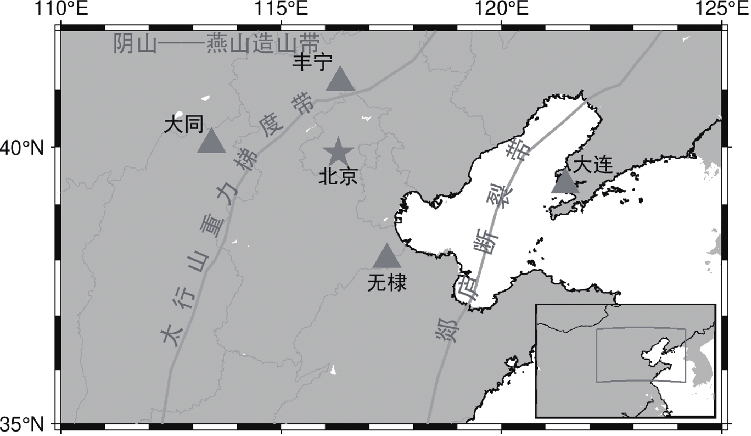
本文研究区位于华北克拉通北缘的首都圈及其周边邻区(110°E—125°E,35°N—42°N)(图1)。研究区西侧的山西断陷带为鄂尔多斯地块与华北盆地的分界,北部为阴山—燕山造山带,整个区域被太行山重力梯度带和郯庐断裂带近南北向贯穿。
1.1 数据来源
本文的大地电磁数据来源于首都圈电磁台网中的四个长周期宽频大地电磁观测台站,即大同台、丰宁台、无棣大山台和大连台。
电磁台站均采用德国Metronix公司生产的ADU-07e大地电磁观测系统进行五分量数据采集,使用的天然场源频段范围为0.000 1—
1000 Hz,数据记录两个正交的电场分量Ex和Ey以及三个磁场分量Hx,Hy和Hz。结合地表与地下介质电阻率数值,根据趋肤深度公式初步估计反演的有效深度可达200 km以上,能够有效覆盖本文研究的莫霍面深度范围(30—45 km)。1.2 数据质量分析
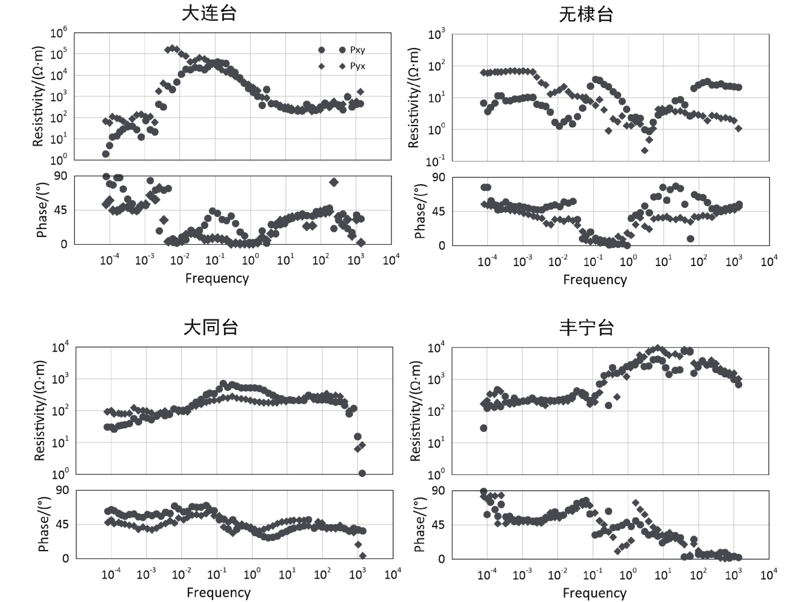
图2给出了大连台、无棣台、大同台和丰宁台xy和yx方向的视电阻率和阻抗相位曲线。可以看出:大连台、丰宁台和大同台的Rxy与Ryx基本重合,地下电性构造的一维性较强;无棣台的Rxy与Ryx差别较大,表明地下电性构造较为复杂;无棣台和大连台临近渤海湾,数据可能会受到海岸效应的影响。通常情况下,横向电场模式(transverse electric,缩写为TE)资料(xy向)相较横向磁场模式(transverse magnetic,缩写为TM)资料(yx向)更不易受海洋效应的影响(杨文采等,1999;张帆等,2012),而且使用TE模式反演对深部电性结构变化更加灵敏(Berdichevsky et al,1998),所以本文均使用xy方向数据进行反演。从原始数据可以看出四个台站的xy方向的数据整体质量较好,除个别飞点之外,视电阻率曲线整体较为平滑和连续。通过使用Rho+方法(Parker,Booker,1996)对视电阻率与相位曲线进行异常值识别,再通过圆滑、剔除与手工编辑等对资料处理后,数据达到了反演要求。
![]() 图 2 大连台、大同台、无棣台和丰宁台的原始长周期电磁观测数据Figure 2. Raw long-period electromagnetic observation data from the stations Dalian,Datong,Wudi,and Fengning
图 2 大连台、大同台、无棣台和丰宁台的原始长周期电磁观测数据Figure 2. Raw long-period electromagnetic observation data from the stations Dalian,Datong,Wudi,and Fengning2. 大地电磁一维反演
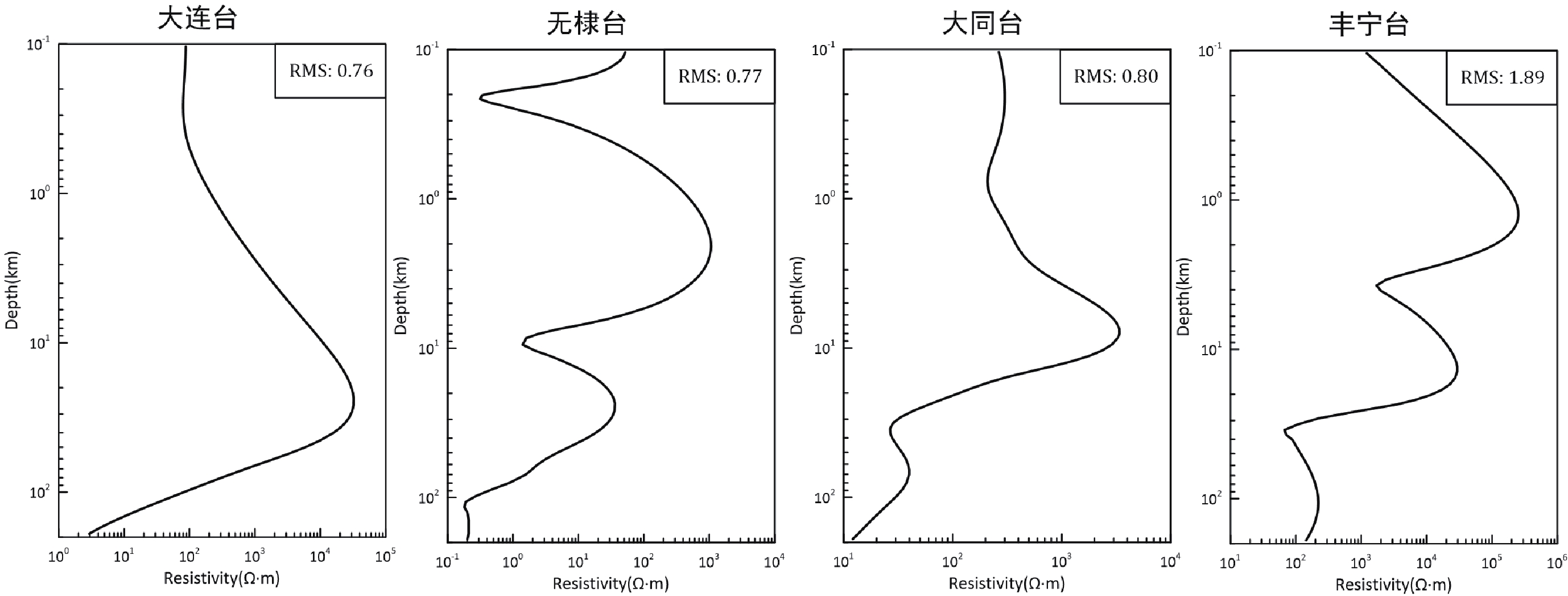
本文使用MTPioneer软件并采用自适应正则化反演方法(陈小斌等,2005)对处理后的数据进行一维反演,设置截断误差为1,反演最大迭代次数为50,初始反演模型为均匀半空间,分别得到了大连台、大同台、无棣台和丰宁台下方的深部电性结构(图3)。
![]() 图 3 大连台、大同台、无棣台和丰宁台的一维大地电磁反演结果Figure 3. One-dimensional magnetotelluric inversion results from the stations Dalian,Datong,Wudi,and Fengning
图 3 大连台、大同台、无棣台和丰宁台的一维大地电磁反演结果Figure 3. One-dimensional magnetotelluric inversion results from the stations Dalian,Datong,Wudi,and Fengning2.1 地下电性结构
图3为四个台站的一维大地电磁数据反演结果,其中大连台、无棣台、大同台和丰宁台反演的均方根误差(root mean square,缩写为RMS)分别为0.52,0.77,0.80和1.89,反演实际迭代次数分别为5,14,9和9。
大连台位于辽东半岛南部、郯庐断裂带东侧的华北地台次级构造单元的辽吉地块的金州断裂附近(图1)。从图3的反演结果可见:大连台下方电性结构较为简单,1 km以内电阻率曲线随深度变化较为平缓,平均电阻率较高,约为102 Ω·m,前人研究结果表明该区域的浅部波速偏高(李志伟等,2006),符合辽东地区结晶基底主要由太古代和元古代地层组成、区域普遍出露固结的岩浆侵入岩特征(卢造勋等,2002);到了1 km深度以下电阻率开始快速增大,在40 km左右增大到104 Ω·m以上,随后又快速下降。反演结果与大连台附近大地电磁二维反演所得地下电性结构模型的电阻率变化趋势(董泽义等,2022)基本一致。
无棣台毗邻渤海海域,地处华北地台的冀东—渤海断块的埕宁隆起区,该区域有一座孤立的第四纪陆内单成因火山,火山中心与无棣台的位置基本重合(毛翔等,2020)。该台站下方反演的电阻率整体可以反映出该火山下方的电性构造特征。张继红等(2019)分别在无棣台以及山东地区更靠近内陆的安丘台和莒县台开展了地下二维电性结构研究,其结果显示安丘台和莒县台的近地表电阻率值均远高于无棣台,推测该情况可能是由于无棣台临近渤海,地表长期遭受海水侵蚀形成了强导电性的表层电阻率特征。无棣大山台的反演结果在浅部1 km以内呈现高导特征,电阻率值最低可达0.3 Ω·m;在10 km处存在一个极小值,该处的电阻率约为2 Ω·m;往下到达约30 km处,存在一个电阻率极大值点,其值大约为400 Ω·m。
大同台位于大同第四纪火山区,地处华北克拉通地块的山西断陷带内。大同台下方电阻率曲线整体呈低—高—低态势,在3 km深度范围内变化不大,3 km以下电阻率随深度增大逐渐增加,到达10 km左右达到极大值(约6 000 Ω·m),在大约40 km以下又进入到电阻率的低值区。从该地区已发表的文献来看,在该点大约40—70 km深度范围内同时存在着较低速度(Lei,2012;侯爵等,2023)和较高温度(Guo et al,2016)的特征,大同台的电性结构与Zhang等(2016)推测的大同火山区存在的一个部分熔融的第四纪活动地幔源位置基本重合。
丰宁台位于阴山—燕山造山带与太行山重力梯度带这两条大型构造带的交界处附近。丰宁台下方电阻率在1 km和20 km处各存在一个极大值点,电阻率分别约为3×10⁵ Ω·m和3×10⁴ Ω·m,与Zheng等(2007)在燕山附近所得的高速层分布深度对应一致;两个极小值则分别位于大约3 km和30 km深处,相应的电阻率约为2 000 Ω·m和70 Ω·m。
2.2 电性莫霍面分布
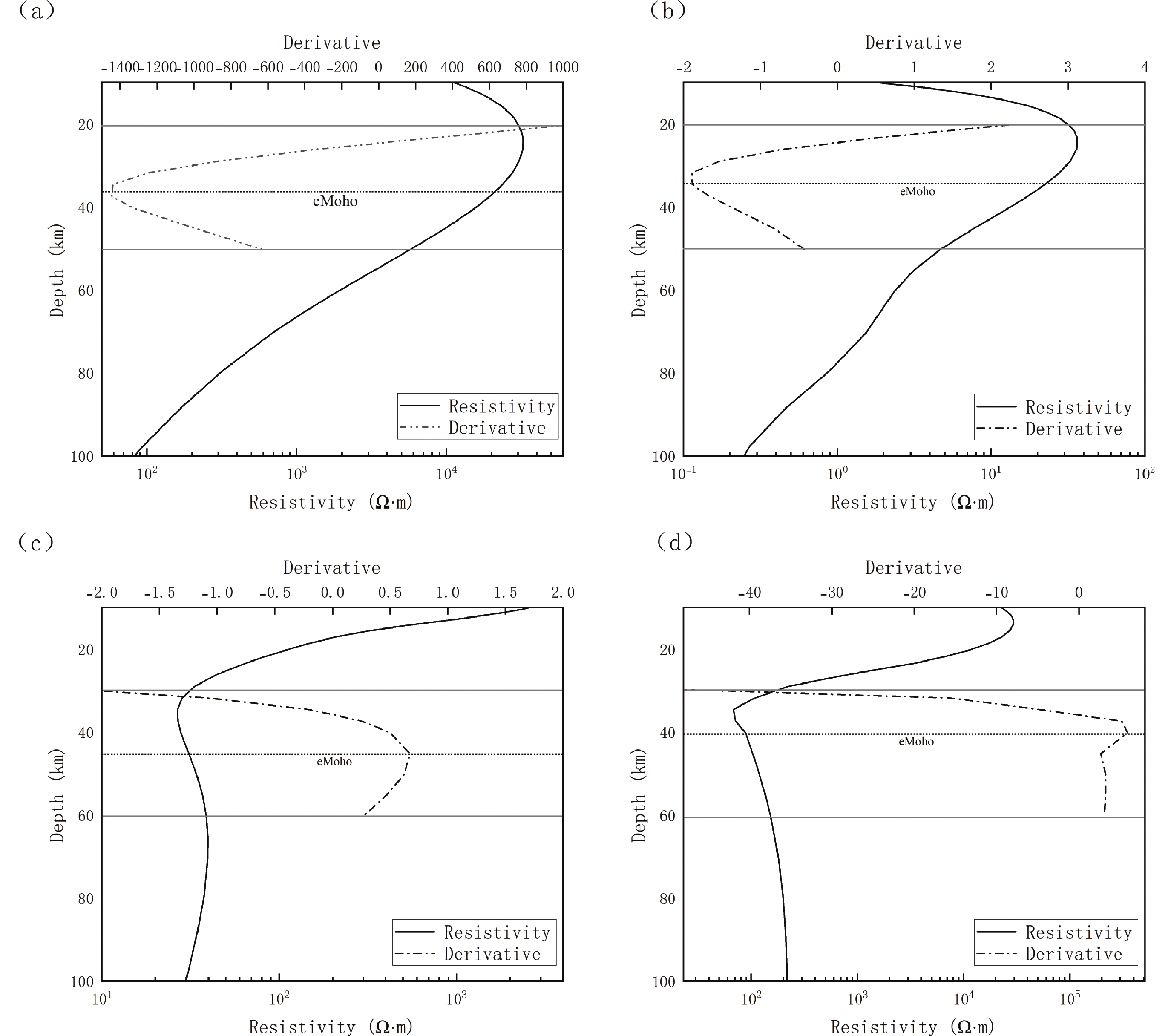
地震波速度和密度曲线在跨越莫霍面时会呈现突变的特征(Dziewonski,Anderson,1981;Kennett and Engdahl,1991)。但是电磁方法由于本身存在的体积效应,对应其物性发生变化的边界位置不会像速度曲线或密度曲线一样发生突变,而往往出现在电阻率变化最快的梯度位置(Auken,Christiansen,2004)。因此本文采取对电阻率曲线求取一阶导数的方式进一步凸显目标体的边界位置(熊治涛等,2023),通过边界增强的方式来求取深部电性构造变化最显著的电性莫霍面的边界位置。
本文采用精度较高的五点拉格朗日插值函数作为求导公式,其表达式为
$$ {f}'={L}_{0}'{f}_{0} + {L}_{1}'{f}_{1} + {L}_{2}'{f}_{2} + {L}_{3}'{f}_{3} + {L}_{4}'{f}_{4} \text{,} $$ (1) 式中,$ {L}_{i}' ( i=0,1,2,3,4 ) $为拉格朗日插值函数的一阶导数,fi为相应反演所得的电阻率值。
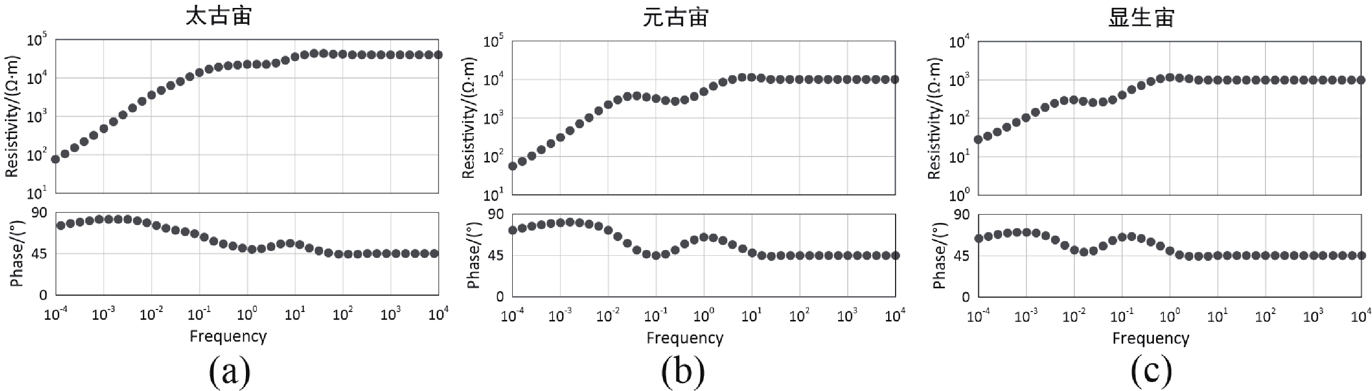
首先通过建立理论合成地层模型来验证该方法求取eMoho的可行性。根据实际观测数据统计得到的岩石圈电性参数(Hyndman et al,1989;Jones,1992)修改,本文分别建立三个地层模型分别代表太古宙、元古宙、显生宙时代地层,其中太古宙和元古宙地层模型的壳幔分界面设置在40 km深度处,显生宙地层模型的壳幔分界面设置在35 km深度处,软流圈层设置为均匀半空间,模型具体参数如表1所示。
表 1 三个地层模型的详细参数(修改自Jones,2013)Table 1. Detailed parameters of three stratigraphic models (modified from Jones,2013)地层
模型上地壳 下地壳 岩石圈地幔 软流圈 电阻率/(Ω·m) 厚度/km 电阻率/(Ω·m) 厚度/km 电阻率/(Ω·m) 厚度/km 电阻率/(Ω·m) 太古宙 40 000 20 10 000 20 50 000,5 000,500 40,70,75 10 元古宙 10 000 20 1 000 20 50 000,5 000,500 40,50,45 10 显生宙 1 000 17.5 87.5 17.5 5 000,500 35,25 10 图4为三个模型的正演响应,使用与实测数据相同的反演算法,基于三个模型反演得到了其电阻率—深度曲线(图5)。
![]() 图 5 三个理论模型正演响应的地电阻率一维反演结果与求导曲线(a)太古宙模型;(b)元古宙模型;(c)显生宙模型Figure 5. 1D inversion results and derivative curves of forward responses for three models(a) Archean model;(b) Proterozoic model;(c) Phanerozoic model
图 5 三个理论模型正演响应的地电阻率一维反演结果与求导曲线(a)太古宙模型;(b)元古宙模型;(c)显生宙模型Figure 5. 1D inversion results and derivative curves of forward responses for three models(a) Archean model;(b) Proterozoic model;(c) Phanerozoic model图5为三个理论模型正演响应的一维反演结果与求导曲线,可以看出反演结果在在模型设置的eMoho位置处(太古宙与元古宙模型40 km,显生宙模型35 km)未表现出存在电阻率界面的特征(如图5中实线所示)。图5中点横线为求导后曲线,使用该方法刻画的eMoho在太古宙模型(图5 a)和元古宙模型(图5 b)中出现在约41 km,显生宙模型(图5 c)约在37 km,与模型设置的eMoho深度基本一致,这表明在下地壳与上地幔其求导曲线能够很好凸显出测点下方的eMoho分布情况,壳幔间电阻率差异越大时这种体现越为显著,且误差越小。
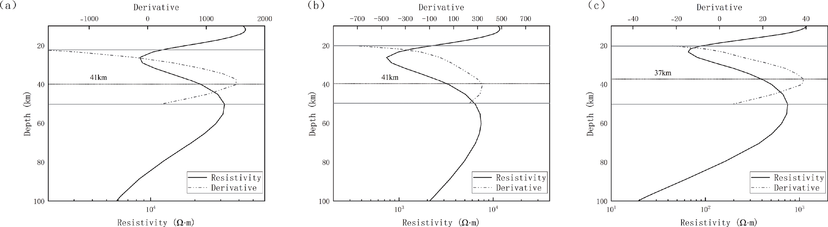
对基于图3所示的四个台站数据的一维反演结果求取导数,结果如图6所示。由于已知华北地区的莫霍面深度范围在20—60 km之内,故求导后仅展示了20—50 km或30—60 km深度范围的导数结果。从图6可以看出,通过对电阻率曲线求取导数后,对地下电性不连续面的刻画能力得以加强,电阻率曲线中不容易看到界面突变的位置(如图6中点横线所示)也得到了显著增强。这样得到大连台、无棣台、大同台和丰宁台的电性莫霍面深度大约分别为36 km,34 km,45 km和41 km,该结果与该区域地震方法和重力方法得到的莫霍面深度基本一致(冯锐,1985;曾融生等,1995;滕吉文等,2002)。
![]() 图 6 一维反演结果与求导曲线(a) 大连台;(b) 无棣台;(c) 大同台;(d) 丰宁台Figure 6. One-dimensional inversion results and derivative curves(a) Dalian station;(b) Wudi station;(c) Datong station;(d) Fengning station
图 6 一维反演结果与求导曲线(a) 大连台;(b) 无棣台;(c) 大同台;(d) 丰宁台Figure 6. One-dimensional inversion results and derivative curves(a) Dalian station;(b) Wudi station;(c) Datong station;(d) Fengning station岩石物理实验研究表明,在跨越莫霍面时,干燥的下地壳铁镁质岩石过渡到上地幔超铁镁质岩石,其电阻率可能会增加1个数量级甚至更高(Kariya et al,1983)。从图3和图6可以看出,在丰宁台和大同台,电阻率在跨越莫霍面时电阻率均呈现出了不同程度的增加。本文的反演结果显示出在跨越莫霍面时,电阻率虽未达到数量级程度的增加,但是也增大了1—2倍左右。Wei等(2008)在华北地区开展二维大地电磁研究,其结果显示在华北克拉通中部地区下地壳存在着一个电阻率梯度变化带,该梯度变化可能是由于下地壳中存在一个连续的低电阻率薄层。关于下地壳连续存在低阻层的成因一直备受争议,目前主流的观点主要包括晶界水相流体(grain boundary aqueous fluids)、熔融物质(melts)、石墨薄膜(graphite films)、硫化物与磁铁矿(sulfides and magnetites)以及水合矿物(hydrated minerals)等成因机理(Yang,2011)。结合华北地区的地球化学与地球动力环境分析,这种低电阻率薄层可能源于幔源岩浆物质的上涌导致其下地壳发生部分熔融,在结晶分异作用下形成了硫化物富集作用所致(Xiong et al,2020)。
在大连台和无棣台的反演结果中,电阻率曲线在跨越莫霍面时呈下降特征,这与Jones (2013)得到的加拿大Slave克拉通sno106测点的结果也类似,表明这两个地区可能不符合理论构想的地壳—地幔电阻率均应该由低阻向高阻变化的特征。大连台和无棣台都临近渤海,所以这种特殊的壳幔电阻率特征可能是缘于临海地区的特殊岩石圈结构。无棣台较大连台地下的电阻率整体偏低,它所位于的埕宁隆起整体呈现为高热流区,且地幔热流占比较大(何丽娟等,2001)。对比其它第四纪火山附近的研究结果(Zhang et al,2016;黄翔等,2022),推测在无棣台下方的这种低阻特征可能是由于其上地幔存在一个垂向展布的且整体分布范围较大的低阻区域,而该低阻区域可能是一部分熔融的软流圈热物质上涌的通道。
3. 讨论与结论
本文基于首都圈地区极低频电磁台网四个电磁台站所采集的长周期大地电磁数据,反演得到了各台站下方的深部一维电性结构,反演结果得到的地下电性变化特征与前人研究结果具有较好的一致性。通过建立三类地层模型验证了对反演所得的电阻率曲线求取一阶导数的方式来刻画测点下方的电性莫霍面的深度位置的可行性。对四个台站的反演结果求取导数凸显台站下方的电性莫霍面位置,所得结果与地震和重力方法确定的莫霍面深度整体上基本接近,表明通过大地电磁方法不仅可以得到莫霍面的埋深,并且可以率先从电性变化的角度得到首都圈地区的电性莫霍面深部分布。研究结果对于认识首都圈地区以及其他地区的电性莫霍面分布具有重要的借鉴和指导意义。
通过分析首都圈地区的电阻率变化特征,结合前人在华北地区的研究成果,推测在下地壳出现的低阻薄层可能是在华北克拉通破坏过程中,下地壳物质部分熔融后再发生重新结晶及分异作用形成了硫化物富集而造成的。大连台和无棣台下方出现的特殊壳-幔电阻率变化则可能是由于临海地区的特殊岩石圈结构,无棣台下方的低阻特征可能是软流圈热物质上涌通道形成的低阻区域。对于探究首都圈地区eMoho的成因机制以及与华北地区动力学背景之间的联系,还需对该区域的三维结果进行深入讨论。
感谢中国地震局地质所范晔老师提供极低频电磁台网原始观测数据。
-
![]()
图 2 大连台、大同台、无棣台和丰宁台的原始长周期电磁观测数据
Figure 2. Raw long-period electromagnetic observation data from the stations Dalian,Datong,Wudi,and Fengning
![]()
图 3 大连台、大同台、无棣台和丰宁台的一维大地电磁反演结果
Figure 3. One-dimensional magnetotelluric inversion results from the stations Dalian,Datong,Wudi,and Fengning
![]()
图 5 三个理论模型正演响应的地电阻率一维反演结果与求导曲线
(a)太古宙模型;(b)元古宙模型;(c)显生宙模型
Figure 5. 1D inversion results and derivative curves of forward responses for three models
(a) Archean model;(b) Proterozoic model;(c) Phanerozoic model
![]()
图 6 一维反演结果与求导曲线
(a) 大连台;(b) 无棣台;(c) 大同台;(d) 丰宁台
Figure 6. One-dimensional inversion results and derivative curves
(a) Dalian station;(b) Wudi station;(c) Datong station;(d) Fengning station
表 1 三个地层模型的详细参数(修改自Jones,2013)
Table 1 Detailed parameters of three stratigraphic models (modified from Jones,2013)
地层
模型上地壳 下地壳 岩石圈地幔 软流圈 电阻率/(Ω·m) 厚度/km 电阻率/(Ω·m) 厚度/km 电阻率/(Ω·m) 厚度/km 电阻率/(Ω·m) 太古宙 40 000 20 10 000 20 50 000,5 000,500 40,70,75 10 元古宙 10 000 20 1 000 20 50 000,5 000,500 40,50,45 10 显生宙 1 000 17.5 87.5 17.5 5 000,500 35,25 10  下载: 导出CSV
-
陈小斌,赵国泽,汤吉,詹艳,王继军. 2005. 大地电磁自适应正则化反演算法[J]. 地球物理学报,48(4):937–946. doi: 10.3321/j.issn:0001-5733.2005.04.029 Chen X B,Zhao G Z,Tang J,Jan Y,Wang J J. 2005. Adaptive regularization inversion algorithm for magnetotelluric data[J]. Chinese Journal of Geophysics,48(4):937–946 (in Chinese).
陈学忠,李艳娥,陈丽娟. 2021. 唐山MS7.8地震前b值异常特征[J]. 地球物理学报,64(10):3612–3618. doi: 10.6038/cjg2021O0476 Chen X Z,Li Y E,Chen L J. 2021. Abnormal characteristics of b-value before the MS7.8 Tangshan earthquake[J]. Chinese Journal of Geophysics,64(10):3612–3618 (in Chinese).
董泽义,汤吉,赵国泽,陈小斌,崔腾发,韩冰,姜峰,王立凤. 2022. 首都圈极低频电磁台网区地下电性结构探测[J]. 地震地质,44(3):649–668. doi: 10.3969/j.issn.0253-4967.2022.03.006 Dong Z Y,Tang J,Zhao G Z,Chen X B,Cui T F,Han B,Jiang F,Wang L F. 2022. Detection of subsurface electrical structures in the Capital Region using very low frequency electromagnetic array[J]. Seismology and Geology,44(3):649–668 (in Chinese).
冯锐. 1985. 中国地壳厚度及上地幔密度分布(三维重力反演结果)[J]. 地震学报,7(2):143–157. Feng R. 1985. Distribution of crustal thickness and upper mantle density in China (results of 3D gravity inversion)[J]. Acta Seismologica Sinica,7(2):143–157 (in Chinese).
何丽娟,胡圣标,汪集旸. 2001. 中国东部大陆地区岩石圈热结构特征[J]. 自然科学进展,11(9):72–75. He L J,Hu S B,Wang J Y. 2001. Thermal structure characteristics of the lithosphere in the eastern continental area of China[J]. Progress in Natural Science,11(9):72–75 (in Chinese).
侯爵,潘佳铁,李永华,武振波,俞贵平,徐涛. 2023. 华北克拉通中西部地壳S波速度结构及其地质意义[J]. 地球物理学报,66(5):1960–1975. doi: 10.6038/cjg2022Q0287 Hou J,Pan J T,Li Y H,Wu Z B,Yu G P,Xu T. 2023. Crustal S-wave velocity structure and its geological significance in the central-western part of the North China Craton[J]. Chinese Journal of Geophysics,66(5):1960–1975 (in Chinese).
胡祥云,林武乐,杨文采,杨博. 2020. 克拉通岩石圈电性结构研究进展[J]. 中国科学:地球科学,50(11):1533–1554. Hu X Y,Lin W L,Yang W C,Yang B. 2020. Research progress on electrical structure of the cratonic lithosphere[J]. Science China:Earth Sciences,50(11):1533–1554 (in Chinese).
黄金莉,赵大鹏. 2005. 首都圈地区地壳三维P波速度细结构与强震孕育的深部构造环境[J]. 科学通报,50(4):348–355. doi: 10.3321/j.issn:0023-074X.2005.04.009 Huang J L,Zhao D P. 2005. Three-dimensional P-wave velocity fine structure of the crust and the deep structural environment for strong earthquake generation in the capital region[J]. Chinese Science Bulletin,50(4):348–355 (in Chinese). doi: 10.1360/csb2005-50-4-348
黄翔,丁志峰,宁杰远,徐小明. 2022. 基于背景噪声和地震面波联合反演华北克拉通中部岩石圈结构[J]. 地震学报,44(4):539–554. doi: 10.11939/jass.20210042 Huang X,Ding Z F,Ning J Y,Xu X M. 2022. Joint inversion of background noise and seismic surface waves for lithospheric structure in the Central North China Craton[J]. Acta Seismologica Sinica,44(4):539–554 (in Chinese).
嘉世旭,齐诚,王夫运,陈棋福,张先康,陈顒. 2005. 首都圈地壳网格化三维结构[J]. 地球物理学报,48(6):1316–1324. doi: 10.3321/j.issn:0001-5733.2005.06.014 Jia S X,Qi C,Wang F Y,Chen Q F,Zhang X K,Chen Y. 2005. Three-dimensional crustal grid structure in the Capital Region[J]. Chinese Journal of Geophysics,48(6):1316–1324 (in Chinese). doi: 10.1002/cjg2.779
姜文亮,张景发. 2012. 首都圈地区精细地壳结构——基于重力场的反演[J]. 地球物理学报,55(5):1646–1661. doi: 10.6038/j.issn.0001-5733.2012.05.022 Jiang W L,Zhang J F. 2012. Fine crustal structure in the Capital Region based on gravity field inversion[J]. Chinese Journal of Geophysics,55(5):1646–1661 (in Chinese).
李志伟,胥颐,郝天珧,刘劲松,张岭. 2006. 环渤海地区的地震层析成像与地壳上地幔结构[J]. 地球物理学报,49(3):797–804. doi: 10.3321/j.issn:0001-5733.2006.03.023 Li Z W,Xu Y,Hao T Y,Liu J S,Zhang L. 2006. Seismic tomography and crustal-upper mantle structure in the Circum-Bohai Sea Region[J]. Chinese Journal of Geophysics,49(3):797–804 (in Chinese).
卢造勋,蒋秀琴,潘科,白云,姜德录,肖立萍,刘建华,刘福田,陈辉,何建坤. 2002. 中朝地台东北缘地区的地震层析成像[J]. 地球物理学报,45(3):338–351,446−448. doi: 10.3321/j.issn:0001-5733.2002.03.006 Lu Z X,Jiang X Q,Pan K,Bai Y,Jiang D L,Xiao L P,Liu J H,Liu F T,Chen H,He J K. 2002. Seismic tomography imaging in the northeastern margin of the Sino-Korean Plate[J]. Chinese Journal of Geophysics,45(3):338–351,446−448 (in Chinese).
毛翔,罗璐,汪新伟,国殿斌. 2020. 渤海湾盆地新生代火山岩分布特征及其地热勘探潜力[J]. 现代地质,34(4):858–864. Mao X,Luo L,Wang X W,Guo D B. 2020. Distribution characteristics of Neogene volcanic rocks in the Bohai Bay Basin and their geothermal exploration potential[J]. Geological Bulletin of China,34(4):858–864 (in Chinese).
唐新功,陈永顺,唐哲. 2006. 应用布格重力异常研究郯庐断裂构造[J]. 地震学报,28(6):603–610,679. doi: 10.3321/j.issn:0253-3782.2006.06.005 Tang X G,Chen Y S,Tang Z. 2006. Study on the Tanlu Fault structure using Bouguer gravity anomaly[J]. Acta Seismologica Sinica,28(6):603–610,679 (in Chinese).
滕吉文,白登海,杨辉,闫雅芬,张洪双,张永谦,阮小敏. 2008. 2008汶川MS8.0地震发生的深层过程和动力学响应[J]. 地球物理学报,51(5):1385–1402. doi: 10.3321/j.issn:0001-5733.2008.05.012 Teng J W,Bai D H,Yang H,Yan Y F,Zhang H S,Zhang Y Q,Ruan X M. 2008. Deep processes and dynamic response of the 2008 Wenchuan MS 8.0 earthquake[J]. Chinese Journal of Geophysics,51(5):1385–1402 (in Chinese).
滕吉文,闫雅芬,王光杰,熊熊. 2006. 大别造山带与郯庐断裂带壳、幔结构和陆内“俯冲”的耦合效应[J]. 地球物理学报,49(2):449–457. doi: 10.3321/j.issn:0001-5733.2006.02.018 Teng J W,Yan Y F,Wang G J,Xiong X. 2006. Coupling effects of crustal and mantle structure and inland "subduction" in the Dabie Orogenic Belt and the Tanlu Fault Zone[J]. Chinese Journal of Geophysics,49(2):449–457 (in Chinese).
滕吉文,闫雅芬,张慧,曾融生. 2002. 东亚大陆及周边海域Moho界面深度分布和基本构造格局[J]. 中国科学(D辑:地球科学),32(2):89–100. Teng J W,Yan Y F,Zhang H,Zeng R S. 2002. Depth distribution of the Moho interface and basic tectonic pattern in East Asia and adjacent seas[J]. Science in China (Series D:Earth Sciences),32(2):89–100 (in Chinese).
王椿镛,段永红,吴庆举,王志铄. 2016. 华北强烈地震深部构造环境的探测与研究[J]. 地震学报,38(4):511–549. Wang C Y,Duan Y H,Wu Q J,Wang Z S. 2016. Detection and study of deep structural environment of strong earthquakes in North China[J]. Acta Seismologica Sinica,38(4):511–549 (in Chinese).
魏文博,叶高峰,金胜,邓明,景建恩,彭志强,林昕,宋石磊,唐宝山,屈栓柱,陈凯,杨宏伟,李国强. 2008. 华北地区东部岩石圈导电性结构研究——减薄的华北岩石圈特点[J]. 地学前缘,15(4):204–216. doi: 10.3321/j.issn:1005-2321.2008.04.024 Wei W B,Ye G F,Jin S,Deng M,Jing J E,Peng Z Q,Lin X,Song S L,Tang B S,Qu S Z,Chen K,Yang H W,Li G Q. 2008. Study on the electrical structure of the lithosphere in Eastern North China:characteristics of thinning lithosphere in North China[J]. Earth Science Frontiers,15(4):204–216 (in Chinese). doi: 10.1016/S1872-5791(08)60055-X
吴福元,徐义刚,朱日祥,张国伟. 2014. 克拉通岩石圈减薄与破坏[J]. 中国科学:地球科学,44(11):2358–2372. Wu F Y,Xu Y G,Zhu R X,Zhang G W. 2014. Thinning and destruction of the cratonic lithosphere[J]. Science China:Earth Sciences,44(11):2358–2372 (in Chinese).
熊治涛,唐新功,张连群,李丹丹,余俊虎. 2023. 线源三维井地电法异常边界增强及地形校正技术[J]. 地震学报,45(1):46–61. doi: 10.11939/jass.20220074 Xiong Z T,Tang X G,Zhang L Q,Li D D,Yu J H. 2023. Enhancement of anomalous boundaries in 3D induced polarization logging and terrain correction techniques[J]. Acta Seismologica Sinica,45(1):46–61 (in Chinese).
杨文采,方慧,程振炎,徐宝利,白金. 1999. 苏鲁超高压变质带北部地球物理调查(Ⅱ)──非地震方法[J]. 地球物理学报,42(4):508–519. doi: 10.3321/j.issn:0001-5733.1999.04.009 Yang W C,Fang H,Cheng Z Y,Xu B L,Bai J. 1999. Geophysical survey in the northern part of the Sulu UHP metamorphic belt (Ⅱ) ── Non-seismic methods[J]. Chinese Journal of Geophysics,42(4):508–519 (in Chinese).
叶高峰,魏文博,金胜,景建恩. 2009. 郯庐断裂带中段电性结构及其地学意义研究[J]. 地球物理学报,52(11):2818–2825. Ye G F,Wei W B,Jin S,Jing J E. 2009. Study on the electrical structure and geological significance of the middle segment of the Tanlu Fault Zone[J]. Chinese Journal of Geophysics,52(11):2818–2825 (in Chinese).
尹京苑,梅世蓉,薛艳. 1999. 邢台地震区地壳速度结构特征与强震孕育发生的关系[J]. 地球物理学报,42(05):629–639. doi: 10.3321/j.issn:0001-5733.1999.05.006 Yin J Y,Mei S R,Xue Y. 1999. Relationship between crustal velocity structure characteristics and the generation of strong earthquakes in the Xingtai seismic zone[J]. Chinese Journal of Geophysics,42(05):629–639 (in Chinese).
张帆,魏文博,金胜,叶高峰,景建恩,张乐天,董浩,谢成良,王辉. 2012. 海岸效应对近海地区大地电磁测深数据畸变作用研究[J]. 地球物理学报,55(12):4023–4035. doi: 10.6038/j.issn.0001-5733.2012.12.014 Zhang F,Wei W B,Jin S,Ye G F,Jing J E,Zhang L T,Dong H,Xie C L,Wang H. 2012. Study on the distortion effect of coastal effect on magnetotelluric sounding data in offshore areas[J]. Chinese Journal of Geophysics,55(12):4023–4035 (in Chinese).
张继红,赵国泽,董泽义,王立凤,韩冰,王庆林,唐廷梅,王梅. 2019. 郯庐断裂带安丘、莒县电磁台地壳电性结构研究[J]. 地震地质,41(5):1239–1253. doi: 10.3969/j.issn.0253-4967.2019.05.011 Zhang J H,Zhao G Z,Dong Z Y,Wang L F,Han B,Wang Q L,Tang T M,Wang M. 2019. Study on crustal electrical structure in Anqiu and Juxian by electromagnetic stations along the Tanlu fault zone[J]. Seismology and Geology,41(5):1239–1253 (in Chinese).
张继红,赵国泽,肖骑彬,汤吉. 2010. 郯庐断裂带中段(沂沭断裂带)电性结构研究与孕震环境[J]. 地球物理学报,53(3):605–611. Zhang J H,Zhao G Z,Xiao Q B,Tang J. 2010. Study on electrical structure and seismic environment of the middle segment (Yishu fault zone) of the Tanlu Fault Zone[J]. Chinese Journal of Geophysics,53(3):605–611 (in Chinese).
曾融生. 1964. 莫霍界面的性质[J]. 地球物理学报,13(2):180–188. Zeng R S. 1964. The nature of the Moho interface[J]. Chinese Journal of Geophysics,13(2):180–188 (in Chinese).
曾融生,孙为国,毛桐恩,林中洋,胡鸿翔,陈光英,1995. 中国大陆莫霍界面深度图[J]. 地震学报, 17 (3):322-327. Zeng R S,Sun W G,Mao T E,Lin Z Y,Hu H X,Chen G Y. 1995. Depth map of the Moho interface in Mainland China[J]. Acta Seismologica Sinica,17(3):322–327 (in Chinese).
朱日祥,陈凌,吴福元,刘俊来. 2011. 华北克拉通破坏的时间、范围与机制[J]. 中国科学:地球科学,41(5):583–592. Zhu R X,Chen L,Wu F Y,Liu J L. 2011. Timing,scope,and mechanism of destruction of the North China Craton[J]. Science China:Earth Sciences,41(5):583–592 (in Chinese).
朱日祥,徐义刚,朱光,张宏福,夏群科,郑天愉. 2012. 华北克拉通破坏[J]. 中国科学:地球科学,42(8):1135–1159. Zhu R X,Xu Y G,Zhu G,Zhang H F,Xia Q K,Zheng T Y. 2012. Destruction of the North China Craton[J]. Science China:Earth Sciences,42(8):1135–1159 (in Chinese).
Audet P,Schutt D L,Schaeffer A J,Estève C,Aster R C,Cubley J F. 2020. Moho variations across the northern Canadian Cordillera[J]. Seismol Res Lett,91(6):3076–3085. doi: 10.1785/0220200166
Auken E,Christiansen A V. 2004. Layered and laterally constrained 2D inversion of resistivity data[J]. Geophysics,69(3):752–761. doi: 10.1190/1.1759461
Berdichevsky M,Dmitriev V,Pozdnjakova E. 1998. On two-dimensional interpretation of magnetotelluric soundings[J]. Geophys J Int,133(3):585–606. doi: 10.1046/j.1365-246X.1998.01333.x
Boudier F,Nicolas A. 1995. Nature of the Moho transition zone in the Oman ophiolite[J]. J Petrol,36(3):777–796. doi: 10.1093/petrology/36.3.777
Chen L. 2009. Lithospheric structure variations between the eastern and central North China Craton from S-and P-receiver function migration[J]. Phys Earth Planet In,173(3-4):216–227. doi: 10.1016/j.pepi.2008.11.011
Chen Y,Saygin E,Kennett B,Qashqai M T,Hauser J,Lumley D,Sandiford M. 2023. Next-generation seismic model of the Australian crust from synchronous and asynchronous ambient noise imaging[J]. Nat Commun,14(1):1192. doi: 10.1038/s41467-023-36514-z
Dunn R A,Watts A B,Xu C,Shillington D J. 2024. A seismic tomography,gravity,and flexure study of the crust and upper mantle structure across the Hawaiian Ridge:2. Ka’ena[J]. J Geophys Res-Sol Ea,129(2):e2023JB028118. doi: 10.1029/2023JB028118
Dziewonski A M,Anderson D L. 1981. Preliminary reference Earth model[J]. Phys Earth Planet In,25(4):297–356. doi: 10.1016/0031-9201(81)90046-7
Guo Z,Afonso J C,Qashqai M T,Yang Y J,Chen Y J. 2016. Thermochemical structure of the North China Craton from multi-observable probabilistic inversion:Extent and causes of cratonic lithosphere modification[J]. Gondwana Res,37:252–265. doi: 10.1016/j.gr.2016.07.002
Hyndman R,Shearer P. 1989. Water in the lower continental crust:modelling magnetotelluric and seismic reflection results[J]. Geophys J Int,98(2):343–365. doi: 10.1111/j.1365-246X.1989.tb03357.x
Johansen S E,Panzner M,Mittet R,Amundsen H,Lim A. 2019. Deep electrical imaging of the ultraslow-spreading Mohns Ridge[J]. Nature,567(7748):379–383. doi: 10.1038/s41586-019-1010-0
Jones A G. 1992. Electrical conductivity of the continental lower crust[J]. Cont Lower Crust:81-143.
Jones A G. 2013. Imaging and observing the electrical Moho[J]. Tectonophysics,609:423–436. doi: 10.1016/j.tecto.2013.02.025
Jones A G,Ferguson I J. 2001. The electric Moho[J]. Nature,409(6818):331–333. doi: 10.1038/35053053
Kariya K A,Shankland T J. 1983. Electrical conductivity of dry lower crustal rocks[J]. Geophysics,48(1):52–61. doi: 10.1190/1.1441407
Kennett B L N,Engdahl E R. 1991. Traveltimes for global earthquake location and phase identification[J]. Geophys J Int,105(2):429–465. doi: 10.1111/j.1365-246X.1991.tb06724.x
Lei J S. 2012. Upper-mantle tomography and dynamics beneath the North China Craton[J]. J Geophys Res-Sol Ea,117:B06313.
Menzies M A,Xu Y G. 1998. Geodynamics of the North China Craton[M]. in Mantle dynamics and plate interactions in East Asia. American Geophysical Union (AGU):155-165.
Mohorovičić A. 1910. Godišnje izvješče Zagrebačkog Meteorološkog Opservatorija:za godinu 1909[M]. Albrechts.
Moisio K,Kaikkonen P. 2001. Geodynamics and rheology of the lithosphere along the DSS profile SVEKA in the central Fennoscandian Shield[J]. Tectonophysics,340(1):61–77.
Molnar P,Tapponnier P. 1975. Cenozoic tectonics of Asia:Effects of a continental collision:Features of recent continental tectonics in Asia can be interpreted as results of the India-Eurasia collision[J]. Science,189(4201):419–426. doi: 10.1126/science.189.4201.419
O’Reilly S Y,Griffin W L. 2013. Moho vs crust–mantle boundary:Evolution of an idea[J]. Tectonophysics,609:535–546. doi: 10.1016/j.tecto.2012.12.031
Parker R L,Booker J R. 1996. Optimal one-dimensional inversion and bounding of magnetotelluric apparent resistivity and phase measurements[J]. Phys Earth Planet Int,98(3-4):269–282. doi: 10.1016/S0031-9201(96)03191-3
Suresh M,Manglik A,Thiagarajan S. 2023. Basement and lithospheric structure of the central Ganga Basin between the Bundelkhand craton and the Sharda Deep by magnetotellurics[J]. Tectonophysics,863:229991. doi: 10.1016/j.tecto.2023.229991
Tang Y C,Chen Y J,Zhou S Y,Ning J Y,Ding Z F. 2013. Lithosphere structure and thickness beneath the North China Craton from joint inversion of ambient noise and surface wave tomography[J]. J Geophys Res:Sol Earth,118(5):2333–2346. doi: 10.1002/jgrb.50191
Tapponnier P,Xu Z Q,Roger F,Meyer B,Arnaud N,Wittlinger G,Yang J S. 2001. Oblique stepwise rise and growth of the Tibet Plateau[J]. Science,294(5547):1671–1677. doi: 10.1126/science.105978
Wei W B,Ye G F,Jin S,Deng M,Jing J E. 2008. Geoelectric structure of lithosphere beneath Eastern North China:Features of thinned lithosphere from magnetotelluric soundings[J]. Earth Sci Front,15(4):204–216. doi: 10.1016/S1872-5791(08)60055-X
Xiong L,Zhao X F,Wei J H,Jin X Y,Fu L B,Lin Z W. 2020. Linking Mesozoic lode gold deposits to metal-fertilized lower continental crust in the North China Craton:Evidence from Pb isotope systematics[J]. Chem Geol,533:119440. doi: 10.1016/j.chemgeo.2019.119440
Xu Y,Zeyen H,Hao T Y,Santosh M,Li Z W,Huang S,Xing J. 2016. Lithospheric structure of the North China Craton:integrated gravity,geoid and topography data[J]. Gondwana Res,34:315–323. doi: 10.1016/j.gr.2015.03.010
Yang X. 2011. Origin of high electrical conductivity in the lower continental crust:A review[J]. Surv Geophys,32(6):875–903. doi: 10.1007/s10712-011-9145-z
Ye T,Chen X B,Huang Q H,Zhao L,Zhang Y,Uyeshima M. 2020. Bifurcated crustal channel flow and seismogenic structures of intraplate earthquakes in Western Yunnan,China as revealed by three-dimensional magnetotelluric imaging[J]. J Geophys Res:Solid Earth,125(9):e2019JB018991. doi: 10.1029/2019JB018991
Ye T,Huang Q H,Chen X B,Zhang H Q,Chen Y J,Zhao L,Zhang Y. 2018. Magma chamber and crustal channel flow structures in the Tengchong volcano area from 3-D MT inversion at the intracontinental block boundary southeast of the Tibetan Plateau [J]. J Geophys Res:Solid Earth, 123 (12):11,112-11 126.
Zhang H Q,Huang Q H,Zhao G Z,Guo Z,Chen Y J. 2016. Three-dimensional conductivity model of crust and uppermost mantle at the northern Trans North China Orogen:Evidence for a mantle source of Datong volcanoes[J]. Earth Planet Sci Lett,453:182–192. doi: 10.1016/j.jpgl.2016.08.025
Zheng T Y,Chen L,Zhao L,Zhu R X. 2007. Crustal structure across the Yanshan belt at the northern margin of the North China Craton[J]. Phys Earth Planet Inter,161(1):36–49.
Zheng T Y,Zhao L,He Y M,Zhu R X. 2014. Seismic imaging of crustal reworking and lithospheric modification in eastern China[J]. Geophys J Int,196(2):656–670. doi: 10.1093/gji/ggt420
Zheng T Y,Zhao L,Xu W W,Zhu R X. 2008. Insight into modification of North China Craton from seismological study in the Shandong Province[J]. Geophys Res Lett,35(22):L17306.
Zheng T Y,Zhao L,Zhu R X. 2009. New evidence from seismic imaging for subduction during assembly of the North China craton[J]. Geology,37(5):395–398. doi: 10.1130/G25600A.1
计量
- 文章访问数: 190
- HTML全文浏览量: 15
- PDF下载量: 58
