A study on 660 km discontinuity beneath northeast China
-
摘要: 围绕中国东北地区下方俯冲的西太平洋板块是停滞在地幔过渡带内水平向西伸展, 还是穿透660 km间断面直接进入下地幔, 始终是一个具有争议的问题. 本文基于P--SV转换波对速度间断面的敏感性, 利用中国数字地震台网在东北地区布设的136个固定地震台站记录到的远震波形数据, 通过提取台站下方的接收函数并采用共转换点(CCP)叠加技术, 得到了该区域660 km间断面的起伏变化图像. 结果显示, 东北地区下方660 km间断面下沉幅度超过20 km的区域主要集中在44°N以南、 东西跨度约400 km的范围内. 660 km间断面的下沉表明西北太平洋板块俯冲到了中国东北地区下方, 在较小区域范围内观测到的较大深度异常可能暗示着俯冲板片穿透660 km间断面直接进入了下地幔.Abstract: It is highly debated on whether the subduction Pacific slab becomes stagnant in the transition zone and extends horizontally or it penetrates into the lower mantle when the leading of the Pacific slab reaches to a depth of 660 km beneath northeast China. Taking advantage of the sensitivity of P--SV conversions to the velocity discontinuities, we employ receiver function method to constrain the topography variation of the 660 km discontinuity beneath northeast China using common conversion point (CCP) stacking. The teleseismic data recorded by 136 permanent stations operated by CDSN in northeast China are used in this study. Our results show that the 660 km discontinuity deepening more than 20 km was observed in the region to the south of 44°N with length about 400 km in the east-west direction. The local depression of the 660 km discontinuity supports that the Pacific subduction slab has reached northeast China and it may penetrates into the lower mantle locally.
-
Keywords:
- northeast China /
- subduction slab /
- receiver function /
- CCP stacking /
- 660 km discontinuity
-
引言
西太平洋俯冲带北起千岛群岛,中经日本海及伊豆-小笠原地区,南至马里亚纳群岛,是世界上最典型、 最集中的俯冲带,也是板块构造学说和地球动力学研究的重点地区(臧绍先,宁杰远,1996). 日本海俯冲带是太平洋俯冲带的一部分,在日本海沟以29°倾角向西俯冲至我国东北地区下方约600 km深度附近(周元泽,臧绍先,2001; 李学清,2004),造就了我国大陆唯一的深源地震区,东北地区因此成为研究俯冲的海洋岩石圈板块与大陆地幔相互作用的理想场所(张瑞青,2010). 另外,长白山火山与镜泊湖火山群等均位于我国东北地区,是陆内火山的典型代表. 这些陆内火山的存在,使得我国东北地区成为俯冲带研究的热点地区.
在660 km深度附近,地震波速度存在明显的不连续现象. 作为上、 下地幔的分界面,该速度间断面(以下简称为660 km间断面)已经在全球范围内被许多地震观测资料所证实(Dziewonski,Anderson,1981; Flanagan,Shearer,1998). 目前普遍认为660 km间断面的形成主要是由橄榄石的后尖晶石相变引起的(Ito,Takahashi,1989). 高温高压实验表明,后尖晶石相变是一放热过程,这意味着在低温异常情况下660 km相变界面加深,反之抬升. 由于海洋岩石圈板块具有明显的低温异常,因此当板片俯冲至660 km深度附近时,常观测到该间断面具有明显下沉迹象.
海洋岩石圈板块在以负浮力为主的作用力驱使下向地球深部俯冲(Elsasser,1967; Forsyth,Uyeda,1975). 当其抵达过渡带底部时,在大于660 km深度时才会发生相变,这样同一深度处板块周围已经发生相变的物质由于密度相对较大,对板块的继续俯冲会产生一定的阻滞作用(石耀霖,2001). 俯冲的板块能否穿透660 km间断面,对地球物质循环和地幔对流模式的研究具有重大意义. 若660 km间断面能够阻碍俯冲板块下插,则支持地幔分层对流模式,反之则支持全地幔对流模式(臧绍先,宁杰远,1996; 李学清,2004). 臧绍先和宁杰远(1996)的数值模拟结果显示,俯冲板块在660 km间断面上可能有4种表现形式: ① 直接穿透660 km间断面; ② 在660 km间断面发生滞留堆积,而后缓慢进入下地幔; ③ 停留在该间断面之上,并在水平方向延伸较长距离; ④ 在间断面处发生分裂,其不同部分可分别发生穿透、 堆积或水平延伸. 目前关于西太平洋俯冲带的层析成像研究表明,上述几种情况在不同地区均有出现,但是这些结果之间存在明显差异,甚至有些是相互矛盾的(Creager,Jordan,1984; Kamiya et al,1989; van der Hilst et al,1991; Fukao et al,1992; Yamanaka,1993; Li et al,2000).
前人已采用不同方法对中国东北地区下方太平洋俯冲板块的几何形态和660 km间断面的起伏特征进行了大量研究. 早期层析成像结果显示,日本海俯冲带穿透660 km间断面,至少可深入到800 km深度(Creager,Jordan,1986); Zhou和Clayton(1990)的层析成像结果却支持俯冲板块在660 km间断面上变得水平,并有分叉现象; 邵济安等(2000)认为太平洋板块以26°倾角俯冲至660 km深度附近后,该板块似有停滞,同时伴随一陡直的冷板块下插入下地幔. 近年来应用大量区域地震台网资料获取的走时层析成像结果显示,俯冲的太平洋板块在抵达660 km深度附近时并未直接进入下地幔,而是停滞在过渡带底部,且向西水平延伸1 000 km到达大兴安岭下方(Zhao,2004; Huang,Zhao,2006). 该结果用来支持俯冲板块遇到660 km间断面后受到了较大阻力,因而弯曲变形,近水平地堆滞在过渡带底部.
除层析成像外,接收函数是研究俯冲板块几何形态的另一途径. 基于接收函数对速度间断面的敏感性,一些研究人员对我国东北地区下方660 km间断面进行了深入研究. Ai等(2003)以及Li和Yuan(2003)认为,该地区下方660 km间断面存在一个东西延伸长约400 km的下沉区域,局部下沉达35 km. 据此,推测太平洋板块在牡丹江台附近下方穿透660 km间断面进入了下地幔. 但Gerya等(2004)的研究结果却没有显示牡丹江台附近下方660 km间断面明显下沉.
随着中国数字地震台网建设工作的完成,我国东北地区地震台站近10年来在数量和覆盖范围方面都得到很大提高(郑秀芬等,2009). 这些台站记录了全球范围内发生的大量地震事件. 本文拟利用这些区域地震资料,采用接收函数方法,对我国东北地区下方660 km 间断面的横向变化特征进行分析,以期为西北太平洋板片的俯冲形态特征及其与660 km间断面之间的相互作用方式等提供进一步的地球物理学依据.
1. 数据资料
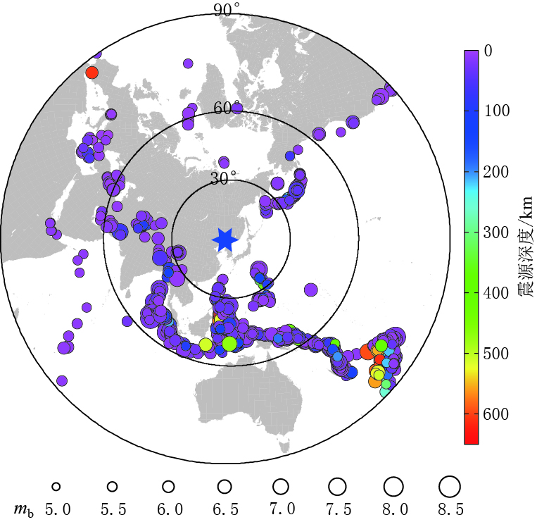
本文使用了136个地震台站自2009年5月—2013年5月记录到的天然地震事件的波形记录,台站分布如图 1所示. 可以看到,所用台站在我国东北地区呈较均匀分布,分别隶属于黑龙江、 吉林、 辽宁、 内蒙古等4个区域地震台网. 为进行接收函数的研究,本文从这些台站记录到的事件中筛选出866个震中距为30°—95°、 mb≥5.0且P波震相清晰的地震事件,其震中分布如图 2所示.为了保证研究结果的可靠性,本文剔除了部分分量方位角异常的台站(Niu,Li,2011)在2012年以前的地震记录.
![]() 图 1 本文所用地震台站及剖面位置分布示意图黑色三角形为本文中所使用的固定台站; 4条红色直线为共转换点(common converted point,简写为CCP)剖面,青色倒三角形为其中心位置;红色三角形为长白山火山; 十字形为P660s的穿透点位置; 白色虚线为俯冲板块等深线(引自Gudmundsson, Sambrige,1988)Figure 1. Distribution of the seismic stations and locations of the profilesBlack triangles denote the permanent seismic stations used in this study.The red lines with its names on the side denote the locations of four CCP profiles and the cyan inverted triangles are their midpoints.The red triangle shows the location of the Changbaishan volcano.The crosses denote piercing pointsof P660s.The white dashed lines are the depth contours of the subduction slab (after Gudmundsson,Sambrige,1988)
图 1 本文所用地震台站及剖面位置分布示意图黑色三角形为本文中所使用的固定台站; 4条红色直线为共转换点(common converted point,简写为CCP)剖面,青色倒三角形为其中心位置;红色三角形为长白山火山; 十字形为P660s的穿透点位置; 白色虚线为俯冲板块等深线(引自Gudmundsson, Sambrige,1988)Figure 1. Distribution of the seismic stations and locations of the profilesBlack triangles denote the permanent seismic stations used in this study.The red lines with its names on the side denote the locations of four CCP profiles and the cyan inverted triangles are their midpoints.The red triangle shows the location of the Changbaishan volcano.The crosses denote piercing pointsof P660s.The white dashed lines are the depth contours of the subduction slab (after Gudmundsson,Sambrige,1988)2. 方法与数据处理
远震体波受到震源时间函数、 传播路径、 接收台站下方的介质结构以及仪器响应等多种因素的共同影响. P波接收函数是从三分量远震P波波形中提取出关于接收介质的水平响应,即用P波记录的垂直分量对水平分量进行反褶积后得到的时间序列,其只与台站下方的物性结构有关,与震源和传播路径基本无关(Vinnik,1977; 吴庆举,曾融生,1998).
地震仪器记录到的垂向地震波信号DV(t)和径向地震波信号DR(t)可表示为

式中,I(t)表示仪器响应,S(t)表示震源时间函数,MS(t)表示震源区介质响应,Mray(t)表示地震波传播路径响应,EV(t)和ER(t)分别表示台站下方介质结构响应的垂向和径向分量.
对于许多波形简单的远震事件的观测(Burdick,Helmberger,1974)和理论计算(Burdick,Langston,1977)表明,远震地表位移的垂直分量可近似表示为尖脉冲的时间函数与仪器响应的褶积. 因此可以认为,台站下方介质结构响应的垂直分量近似为狄拉克函数,故DR(t)可表示为

将DR(t)对DV(t)作反褶积,即可得到ER(t).
将径向分量与垂向分量在频率域直接相除,然后再反变换回到时间域的频率域作反褶积(Helmberger,Wiggins,1971)是求取接收函数常用的一种反褶积方法. 为保证运算的稳定性,需引入“水准量”(Langston,1979). 对于上地幔间断面的探测而言,“水准量”的选择往往很困难,该量值过小难以保证运算稳定性,过大则会压制能量较弱的上地幔间断面转换波震相(司少坤等,2014). 为此,本文采用时间域迭代反褶积方法(Kikuchi,Kanamori,1982)求取接收函数. 其原理是通过最小二乘法使观测到的径向地震记录与迭代计算得到的径向地震记录之差达到最小,其中迭代计算得到的径向地震记录是一系列脉冲信号组成的时间序列与垂向地震记录之间的褶积. 计算时,首先将垂向地震记录与径向地震记录作互相关,求得接收函数中第一个最大脉冲信号的时间延迟和振幅值; 然后将该接收函数与垂向地震记录作卷积以获取径向记录; 最后将计算得到的径向记录与实际观测得到的径向记录作最小二乘运算,若结果低于允许的误差范围,则迭代终止,否则需求取下一个脉冲信号来更新接收函数.
为从固定台站记录到的资料中获取接收函数,本文通过以下步骤对原始地震记录进行处理:
1)选取震中距为30°—95°的地震事件,以IASP91模型的P波理论到时为参考时间,截取P波初至前50 s至后150 s的波形记录;
2)将原始波形记录进行去均值和去倾斜处理,并进行0.05—2 Hz的带通滤波;
3)限定地震记录的垂向分量信噪比大于3;
4)采用多道记录互相关方法(VanDecar,Crosson,1990)将不同台站记录到的同一地震事件进行互相关,以剔除垂向分量互相关系数小于0.7的台站记录;
5)将水平分量的波形记录按照后方位角旋转为径向分量和切向分量;
6)通过时间域迭代反褶积得到P波径向接收函数,相对于频率域反褶积,时间域迭代反褶积虽计算量较大,但其获得的接收函数具有较高的信噪比和分辨率(Ligorría,Ammon,1999;武岩等,2014);
7)对于所获得的径向接收函数再次应用互相关方法,筛选出互相关系数大于0.5的数据.
按照上述步骤,本文共提取到有效接收函数39 701条.
3. 结果
为增强有效信号,压制噪声信号,本文采用共转换点叠加方法对一定范围内的接收函数进行叠加以获取其平均振幅值(Tian et al, 2010,2011). 在CCP叠加过程中,首先将整个研究区域进行三维网格划分,每一个网格称为一个像素点,将所有落入同一像素点范围内的接收函数进行叠加,取其振幅平均值作为该像素点的初值; 然后对各像素点进行一定范围内的滑动平均,最终取经滑动平均的振幅值作为各像素点对应的振幅值. 在进行CCP叠加成像的过程中,需要利用背景速度模型进行时深转换,本文选取IASP91模型作为参考模型(Kennett,Engdahl,1991).
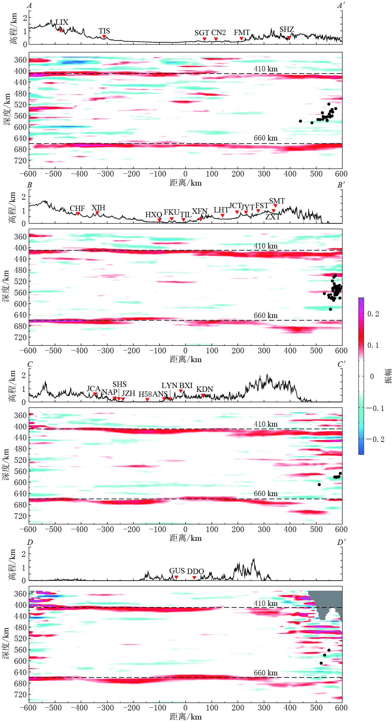
为研究660 km间断面的起伏变化特征,在研究区域内沿纬线方向选取了4条相互平行的CCP剖面,其位置如图 1所示. 4条剖面长度均为1 200 km,其中心点坐标分别为(124°E、 44°N)、(124°E、 42.5°N)、(124°E、 41°N)和(124°E、 40°N). 图 3给出的4条剖面,即AA′,BB′,CC′和DD′显示,在660 km深度附近,各剖面均有明显的波阻抗变化(表现为正的振幅值),表明该处速度间断面的存在.
由AA′剖面可以看出,660 km间断面在150 km距离处开始逐渐下沉,在400 km处下沉至最低点,下沉幅度约为19 km,之后在550 km距离附近重新回到660 km的平均深度位置.这一区域660 km间断面整体表现为沿剖面方向范围达400 km的宽缓弧形下沉.
![]() 图 3 CCP叠加剖面图红色倒三角形表示分布在距剖面30 km范围内的地震台站;黑点表示发生在剖面两侧各50 km范围内的深震事件位置Figure 3. Common conversion point images for the four CCP profilesThe red inverted triangles show the stations within 30 km away from the profile.The horizontal direction denotes distance along profile with its midpoint as 0 km,and the vertical direction denotes depth in the profile.The black dots denote the deep seismic events located 50 km away from the profile; the depths of 410 km and 660 km are indicated as two dashed lines,respectively
图 3 CCP叠加剖面图红色倒三角形表示分布在距剖面30 km范围内的地震台站;黑点表示发生在剖面两侧各50 km范围内的深震事件位置Figure 3. Common conversion point images for the four CCP profilesThe red inverted triangles show the stations within 30 km away from the profile.The horizontal direction denotes distance along profile with its midpoint as 0 km,and the vertical direction denotes depth in the profile.The black dots denote the deep seismic events located 50 km away from the profile; the depths of 410 km and 660 km are indicated as two dashed lines,respectively在其它剖面中,660 km间断面的下沉现象也十分明显. BB′剖面中660 km间断面在270 km距离附近表现为快速下沉,至320 km处最大振幅出现在685 km深度附近,420 km 前后相变界面逐渐变宽,最大振幅深度达694 km; CC′剖面中660 km间断面从约250 km距离处开始下沉,下沉范围持续至550 km,其中,在450—550 km区间内,660 km间断面下沉达45 km; DD′剖面中,660 km间断面在310 km距离附近突然下沉约27 km,之后沿剖面向右平缓回升,在600 km处深度变为609 km.
为探讨我国东北地区下方660 km间断面的起伏变化特征与俯冲的西北太平洋板片之间的关系,我们将剖面两侧各50 km范围内发生的深震震源位置投影至CCP剖面上,如图 3中黑点所示. 从深震发生的位置可以看出,各剖面中660 km间断面下沉最明显的位置与俯冲板块前端较为吻合. 由此可以推断,本文研究区域内660 km间断面的下沉是俯冲的太平洋板块所致.
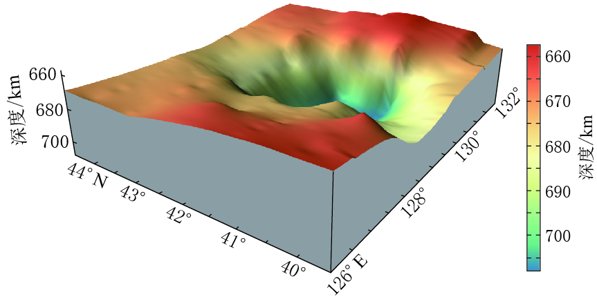
对比各个剖面中的下沉区域可以看出,660 km间断面所在最大深度从AA′剖面中的679 km逐渐加深到CC′剖面的705 km,而后在DD′剖面中变浅为687 km,总体呈中间深两侧浅的形态. 图 4给出了用本文中得到的660 km间断面在40°N—44°N、 126°E—132°E范围内的深度数据绘制的三维表面图.可以看出,660 km间断面在所示区域中间部分呈漏斗状突然大幅下沉.
在接收函数CCP叠加的时深转换中,常选取一个参考模型并根据P波与Ps转换波的到时差来求取速度间断面所在深度,因此间断面埋深常受到上部壳幔介质速度结构变化的影响. 当地壳和上地幔顶部出现明显的低速异常时,会导致CCP剖面中660 km间断面深度整体加深. 为排除所选参考模型对660 km间断面埋深的影响,本文计算了660 km与410 km间断面的深度差,即地幔过渡带厚度,如图 5所示. 地幔过渡带厚度全球平均值约为250 km,本文以240—260 km为地幔过渡带厚度的正常变化范围. 由图 5可知,AA′剖面地幔过渡带厚度未出现显著异常,但在其它3个剖面中,地幔过渡带 厚度明显增厚,但增厚部分多出现在各剖面右侧部分.其中,CC′剖面过渡带厚度异常最为明显,其南北两侧剖面中过渡带厚度异常特征呈逐渐减弱趋势. 该过渡带厚度的异常特征与图 3中660 km间断面的起伏形态基本一致.
4. 讨论与结论
基于接收函数对结构变化界面的敏感性,本文对我国东北地区下方的660 km间断面进行了研究. 结果显示,该区域下方660 km间断面存在局部下沉现象,其下沉幅度超过20 km的区域集中在44°N以南、 东西跨度约400 km的区域范围内,下沉幅度最大达 45 km. 该结果与前人利用接收函数方法在东北地区得到的研究结果较为一致. 例如: Ai等(2003)用接收函数方法得到的结果表明,660 km间断面在40°N—44°N、 128°E—130.5°E范围内发生下沉; Li和Yuan(2003)采用同样方法获取了东北地区660 km间断面的深度,其结果也显示660 km 间断面在一个长约400 km的区域普遍发生下沉,局部区域的下沉幅度甚至超过35 km. 与这些结果相比,本文利用了更多的区域地震台网资料,获取的接收函数多达4万条,因而660 km深度附近的转换点可以对整个研究区域形成很好的覆盖.
一般认为660 km速度间断面是由橄榄石的后尖晶石相变主导的,即林伍德石分解为钙钛矿和铁方镁石(Ito,Takahashi,1989). 由于这一相变具有负的克拉珀龙(Clapeyron)斜率,即随着温度的升高(降低),相变所需的压力会有所降低(升高),因此660 km间断面表现为抬升(下沉). 高温高压实验测定的660 km间断面的克拉珀龙斜率变化范围为-1.3 MPa/K(Fei et al,2004)至-2.8 MPa/K(Ito,Takahashi,1989). 如果采用-2.0 MPa/K的斜率计算,40 km的下沉所对应的低温异常约为667 K.
接收函数与走时层析成像和数值模拟结果具有一致性. 区域层析成像结果显示我国东北地区下方过渡带底部具有明显的P波高速异常,其异常幅度约为2%. 地震波速度的异常常归因于地幔温度的横向变化,而忽略地幔化学成分的不均匀性对地震波速度的影响. 以实验室测定的地震波速度对温度的敏感度-0.43%/100 K计算,约2%(Cammarano et al,2003)的高速异常对应的温度异常约为-450 K,比接收函数所推测的低温异常要低一些. 数值模拟结果(Kawakatsu,Yoshioka,2011)则表明,西北太平洋板块俯冲至地幔过渡带深度时,其中心温度比周围地幔温度低约650 K,与接收函数推测的结果较为吻合.
需要特别指出的是,接收函数中660 km间断面的横向变化特征与区域走时成像中高速异常分布范围具有明显区别. 一些区域层析成像结果显示,以约28°倾角俯冲的太平洋板块在我国东北地区下方500—600 km深度突然变得水平并停滞于地幔过渡带之中,停滞板块由132°E延伸至120°E附近,水平向西达1 000余千米(Zhao,2004; Huang,Zhao,2006). 由此可以推测,660 km间断面应在较大的范围内存在下沉现象,但本文接收函数结果并没有发现660 km间断面的大范围下沉. 从本文的4个CCP剖面可以看出,660 km间断面虽然均出现大幅下沉,但其下沉区域主要集中在沿剖面方向300—400 km宽的局部区域内.
AA′剖面中660 km间断面在150 km距离左侧变化异常平缓,深度保持在667 km上下; BB′剖面中660 km间断面在下沉区域左侧大都保持在 660 km的深度,只是在-230 km 距离附近至-50 km区间呈小幅上升,幅度约为9 km; CC′和DD′剖面中,660 km间断面在300 km距离左侧的形态基本一致,其间断面的深度虽有一定变化,但均保持在±10 km的范围内,尤其是在剖面-400—-600 km距离区间内,其间断面平稳处于660 km深度. 总之,在上述下沉区域之外,各剖面中660 km间断面均未出现大幅下沉的现象.
另外,本文结果与三重震相研究也具有很好的对应性. 三重震相波形模拟认为朝鲜半岛及其周边地区下方过渡带结构存在明显的区域变化(Zhang et al,2012). 朝鲜半岛下方660 km间断面速度跳跃明显要小,而与其毗邻的华北克拉通北部区域下方间断面速度跳跃则与之明显不同,速度跳跃约8.5%. 这样的速度跳跃可支持西北太平洋板块尚未俯冲至华北克拉通北部地区这一结论,也进一步证实了本文的观测结果.
综合本文观测到的660 km间断面的区域性下沉和地幔过渡带的局部增厚,以及深震分布特征、 三重震相等其它地球物理观测结果,本文推测西北太平洋俯冲板块可能并未大面积停滞于地幔过渡带之中,而是在660 km深度附近经过短暂的堆积停留,可能在某些地方将穿透660 km间断面而进入下地幔.
中国地震局地球物理研究所国家数字测震台网数据备份中心(doi:10.7914/SN/CB)为本文提供了地震波形数据(郑秀芬等,2009),在此表示感谢!
-
图 1 本文所用地震台站及剖面位置分布示意图
黑色三角形为本文中所使用的固定台站; 4条红色直线为共转换点(common converted point,简写为CCP)剖面,青色倒三角形为其中心位置;红色三角形为长白山火山; 十字形为P660s的穿透点位置; 白色虚线为俯冲板块等深线(引自Gudmundsson, Sambrige,1988)
Figure 1. Distribution of the seismic stations and locations of the profiles
Black triangles denote the permanent seismic stations used in this study.The red lines with its names on the side denote the locations of four CCP profiles and the cyan inverted triangles are their midpoints.The red triangle shows the location of the Changbaishan volcano.The crosses denote piercing pointsof P660s.The white dashed lines are the depth contours of the subduction slab (after Gudmundsson,Sambrige,1988)
图 3 CCP叠加剖面图
红色倒三角形表示分布在距剖面30 km范围内的地震台站;黑点表示发生在剖面两侧各50 km范围内的深震事件位置
Figure 3. Common conversion point images for the four CCP profiles
The red inverted triangles show the stations within 30 km away from the profile.The horizontal direction denotes distance along profile with its midpoint as 0 km,and the vertical direction denotes depth in the profile.The black dots denote the deep seismic events located 50 km away from the profile; the depths of 410 km and 660 km are indicated as two dashed lines,respectively
-
张瑞青. 2010. 基于三重震相研究青藏高原和西北太平洋俯冲带上地幔过渡带速度结构[D]. 北京: 中国地震局地球物理研究所: 70. Zhang R Q. 2010. Seismic Velocity Models in the Transition Zone Beneath Tibet and Northeast Pacific Subduction Zone by Triplicate Waveform[D]. Beijing: Institute of Geophysics, China Earthquake Administration: 70 (in Chinese).
Elsasser W M. 1967. Convection and stress propagation in the upper mantle[G]//Runcorn S K eds. Hoboken, New York: Wiley-Sons: 223-246. The Application of Modern Physics to the Earth and Planetary Interiors
Yamanaka Y. 1993. Unified Model of the State of Stress in Subducting Slab[D]. Tokyo: University of Tokyo: 16-106.
-
期刊类型引用(6)
1. 王培锋,周勇,徐敏. 基于传播矩阵法改进的SS及其前驱波合成算法. 地球物理学报. 2022(10): 3900-3911 .  百度学术
百度学术
2. He HUANG,Xuzhang SHEN,Xuzhou LIU,Yuansheng ZHANG. Constraining the characters of the upper mantle discontinuities beneath the NE margin of the Tibetan Plateau with a dense broadband seismic array. Science China(Earth Sciences). 2020(03): 425-438 .  必应学术
必应学术
3. 黄河,沈旭章,刘旭宙,张元生. 利用密集宽频带台阵资料研究青藏高原东北缘上地幔间断面性质. 中国科学:地球科学. 2020(03): 418-431 .  百度学术
百度学术
4. Qi-Fu CHEN,Yinshuang AI,Yun CHEN. Overview of deep structures under the Changbaishan volcanic area in Northeast China. Science China(Earth Sciences). 2019(06): 935-952 .  必应学术
必应学术
5. 陈棋福,艾印双,陈赟. 长白山火山区深部结构探测的研究进展与展望. 中国科学:地球科学. 2019(05): 778-795 .  百度学术
百度学术
6. 薛明,王苏,徐晓雅,胡家富. 云南地区的地幔过渡带结构及其动力学意义. 科学通报. 2017(16): 1752-1765 .  百度学术
百度学术
其他类型引用(1)


 下载:
下载:


