Extraction of seismic damage information of the residential area based on medium-resolution remote sensing image
-
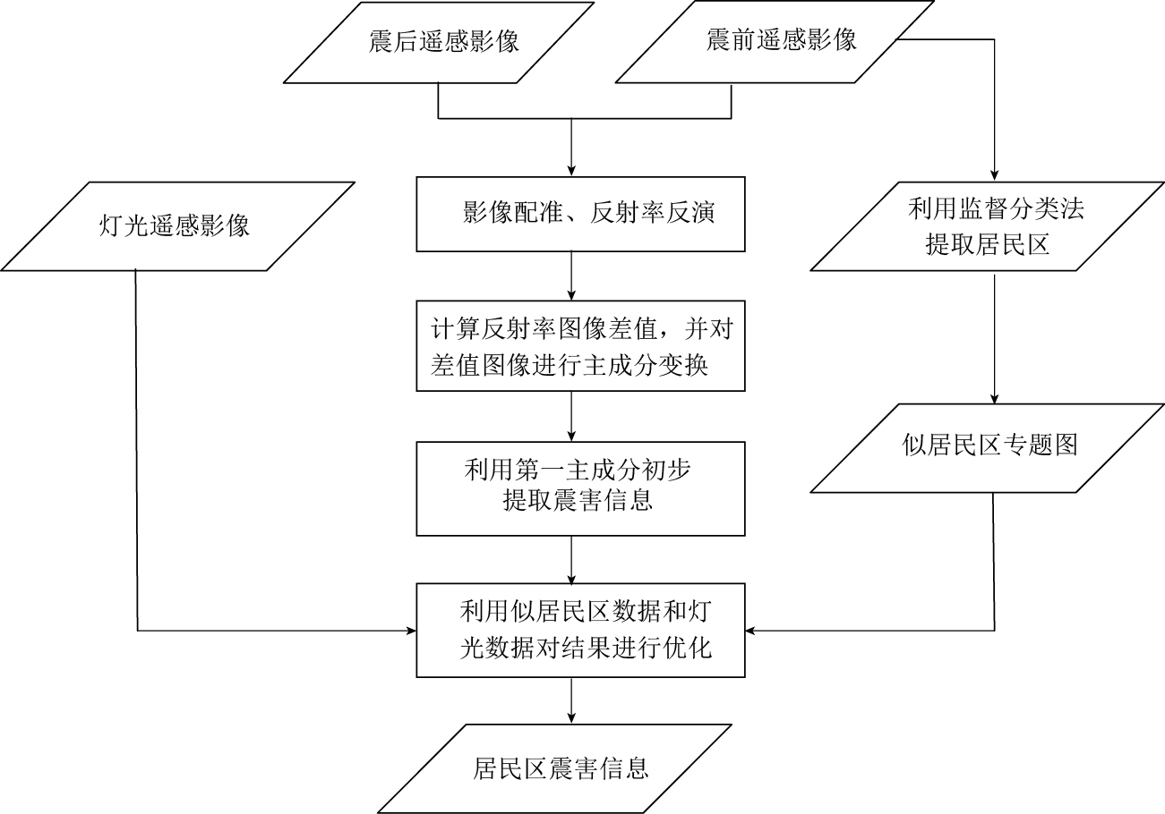
摘要: 针对中分辨率遥感影像建筑物震害信息弱以及变化检测法受非震害信息影响大等弱点, 本文建立了一种基于变化检测的居民区震害信息快速提取方法. 该方法利用主成分变换增强震害信息, 采用监督分类法提取似居民区, 并用灯光影像数据进一步对似居民区提取结果进行优化, 从而很好地消除了变化检测方法中非震害因素的影响. 在此基础上, 以2001年印度MW7.6地震的极重灾区为研究区域, 利用震前、 震后Landsat卫星TM图像和震区灯光影像数据, 对本文算法进行了验证和分析. 结果表明, 在30—50 m中分辨率遥感影像上, 以建筑物为主的居民区震后图像变化最为显著的震害特征是反射率变大, 本文所建立的居民区震害信息提取方法在解决中分辨率遥感影像震害目标信息弱、 背景复杂等方面效果明显.Abstract: There are some weak spots in medium-resolution remote sensing image, such as weak information in seismic disaster of buildings and change detection method prone to be affected by non-seismic disaster information. According to those problems, this paper established a method for quickly extracting residential seismic damage information based on the change detection method, which uses principal component transform to enhance damaged information, and adopts the supervised classification method to extract the similar residential area, which were further optimized by using the nighttime lights data, eliminating the influence of non-seismic disaster factors in the change detection method. And then the meizoseismal area of India MW7.6 earthquake in 2001 is chosen as the studied area by using Landsat thematic mapper (TM) imagery pre- and post-earthquake and nighttime lights data of earthquake-stricken area so as to verify and analyze the method proposed in this paper. The results show that the reflectivity becomes larger is the the most significant damaged characteristic for the building residential area in the resolution of 30--50 m medium-resolution remote sensing image. The method for extracting residential earthquake damage information established in this paper has good effects in solving weakly damaged information and background noise based on medium-resolution images.
-
-
图 7 印度古吉拉特邦震区地震前后反射率图像第一主成分差值图像(a)、 利用似居民区数据 对图7a第一次优化后结果(b)以及利用灯光数据第二次优化后结果(c)
红色箭头所指区域为受薄云影响区域, 红色圆圈内为提取的安贾尔市震害信息
Figure 7. First principal component D-value image about reflectance in Gujarat seismic zone, India (a), the first optimization results using similar residential area extraction algorithm (b), and the second optimization results using nighttime lights data (c). Red arrow refers to the area affected by the cloud area, red circle delineates the earthquake damaged information in Anjar city
-
窦爱霞. 2003. 震害遥感图像变化检测技术研究[D].济南: 山东科技大学地球科学与工程学院: 1-21. Dou A X. 2003. Study on Seismic Damage Change Detecting Technique Based on Riote Sensing Images[D].Ji'nan: College of Earth Science and Engineering, Shandong University of Science and Technology: 1-21 (in Chinese).
柳稼航. 2003. 利用遥感技术进行城市建筑震害的自动识别与分类方法研究[D].北京: 中国地震局地质研究所: 1-10. Liu J H. 2003. A Method Study on Automatic Recognition and Classification of Earthquake-Caused Building Damage in Cities Using Riote Sensing[D].Beijing: Institute of Geology, China Earthquake Administration: 1-10 (in Chinese).
Estrada M, Yamazaki F. 2000. Use of Landsat images for the identification of damage due to the 1999 Kocaeli, Turkey earthquake[C]//Proceedings of the 21st Asian Conference on Riote Sensing. Taipei: ACRS: 1-11.
Hayashi H, Hashitera S, Kohiyama M, Matsuoka M, Maki N, Fujita H, Elvidge C D. 2000. International collaboration for the early damaged area estimation systi using DMSP/OLS nighttime images[C]//Proceedings of IEEE 2000 International Geoscience and Riote Sensing Symposium (CD-ROM). Honolulu: IEEE: 2697-2699.
Matsuoka M, Yamazaki F. 1998. Identification of damaged areas due to the 1995 Hyogoken-Nanbu earthquake using satellite optical images[C]//Proceedings of the 19th Asian Conference on Riote Sensing. Traders Hotel, Manila: 1-6.
Matsuoka M, Yamazaki F. 2004. Use of SAR intensity imagery for earthquake damage detection[C]//Proceedings of the 2nd Workshop on Application of Riote Sensing Technologies for Disaster Response. Newport Beach, California: IEEE: 1-5.
Yusuf Y, Matsuoka M, Yamazaki F. 2002. Detection of building damage due to the 2001 Gujurat, India earthquake, using satellite riote sensing[C]//Proceedings of the 7th National US Conference on Earthquake Engineering. Oakland, California: Earthquake Engineering Research Institute: 21-25.


 下载:
下载:


