Fault locking and dynamic deformation of the Longmenshan fault zone before the 2013 Lushan MS7.0 earthquake
-
摘要: 利用1999-2007和2009-2011年中国大陆GPS水平速度场数据, 采用DEFNODE(反演计算弹性岩石圈块体旋转、 应变和块体边界断层闭锁或同震滑动的Fortran程序)负位错反演程序估算了芦山地震前龙门山断裂带的三维闭锁程度, 并结合剖面结果分析了断层深浅部变形特征. GPS反演结果表明, 1999-2007年, 龙门山断裂中北段(闭锁比例为0.99)处于强闭锁(本文将闭锁比例大于0.97的称为强闭锁)状态; 龙门山断裂南段地表以下深度16 km内为强闭锁, 深度16-21 km处闭锁比例降低为0.62, 深度21-24 km处整条断裂逐渐转变为蠕滑状态. 2009-2011年, 即汶川地震后, 龙门山断裂中北段处于震后蠕滑状态; 龙门山断裂南段深度16-21 km处闭锁比例降低为0.45, 其它位置闭锁程度保持不变. GPS剖面结果显示, 2009-2011年, 即汶川地震后, 龙门山断裂中北段为逆冲兼右旋走滑运动; 而南段断层不能自由滑动、 变形宽度较大. 综合分析认为, 汶川地震时, 龙门山断裂南段并没有发生破裂, 一直处于较强的闭锁状态, 汶川地震的发生又加速了芦山地震的孕育进程; 由于龙门山断裂带南段的闭锁深度较中北段浅, 因此芦山地震较汶川地震强度低、 震级小、 破裂范围窄.
-
关键词:
- 芦山地震 /
- DEFNODE负位错反演 /
- 断层闭锁比例 /
- 滑动亏空 /
- 变形特征
Abstract: By using the negative dislocation model of DEFNODE, a Fortran program to model elastic lithospheric block rotations and strains, and locking or coseismic slip on block-bounding faults, we inverted the GPS horizontal velocity observations during 1999-2007 and 2009-2011 for a 3-D fault locking model of the Longmenshan fault zone before the Lushan earthquake, and analyzed characteristics of fault deformation at different depth in combination with GPS profiles. The inversion results indicate that during 1999-2007 the middle-northern segment of the Longmenshan fault was tightly locked (locked fraction is 0.99). Meanwhile the southern segment of the Longmenshan fault was tightly locked from the surface to the depth of 16 km, and the locked fraction decreases to about 0.62 at the depth of 16-21 km. The whole fault turns to creeping gradually between the depth of 21 km and 24 km. During 2009-2011, i.e., after the Wenchuan earthquake, the middle-northern segment of the Longmenshan fault was in a creeping state. Meanwhile the locked fraction of the southern segment of the Longmenshan fault decreased to about 0.45 at the depth of 16-21 km, and remained unchanged at other depths. In addition, the GPS profiles of 2009-2011 show that the middle-northern segment of the fault was thrust and dextral slip after the Wenchuan earthquake. The southern segment could not slip freely and the deformation width was large. Comprehensive analysis indicates that the southern segment of the Longmenshan fault has no rupture after the Wenchuan earthquake and is still tightly locked, and the Wenchuan earthquake speeds up the preparation process of the Lushan earthquake. Because the locked depth of the southern segment is lower than that of the middle-northern segment, therefore intensity, earthquake magnitude and rupture range of the Lushan earthquake are all less than those of the Wenchuan earthquake. -
-
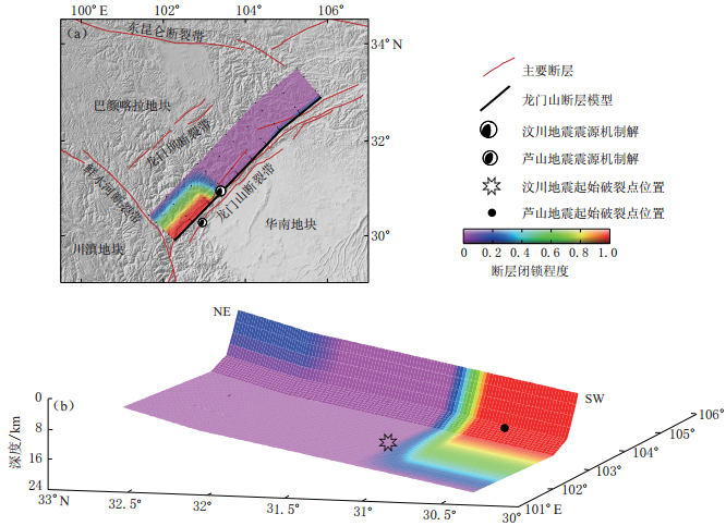
图 3 1999—2007年龙门山断裂闭锁程度(引自赵静等, 2012)(a) 断层闭锁地面投影; (b) 断层闭锁分布
Figure 3. Locking level of the Longmenshan fault during 1999—2007(a) Projection of fault locking; (b) Fault locking distribution
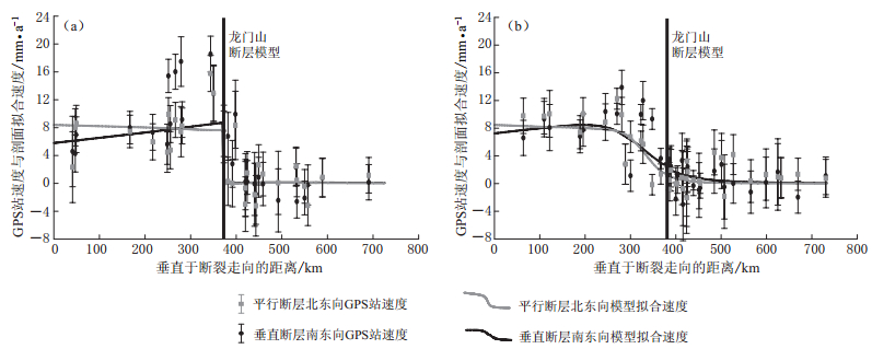
图 6 横跨龙门山断裂中段剖面A和南段剖面B的2009—2011年GPS站速度剖面和拟合结果(相对于华南地块)剖面A、 B位置见图1所示. 图中灰色线为平行断层运动的模型值, 斜率为正表示左旋, 反之为右旋;黑色线为垂直断层运动的模型值, 斜率为正表示拉张, 反之为挤压
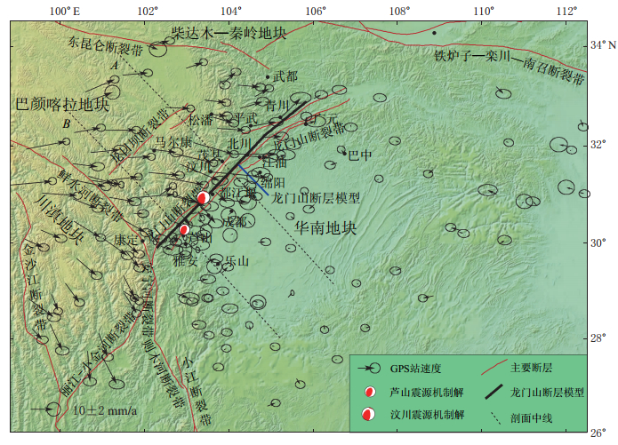
Figure 6. GPS velocity profiles A (a) and B (b) across the middle and the southern segments of the Longmenshan fault during 2009—2011, as well as model fitting results (relative to South China block)Loctions of profiles A and B see Fig. 1. Gray line denotes velocity parallel to fault, positive slope means sinistral slip and negative denotes dextral silp. Black line indicates velocity normal to fault, positive slope indicates extensional slip and negative indicates compressional slip
-
陈运泰, 许力生, 张勇, 杜海林, 冯万鹏, 刘超, 李春来. 2008. 2008年5月12日汶川特大地震震源特性分析报告[R/OL]. [2009-01-05]. http://www.cea-igp.ac.cn/汶川地震专题/地震情况/初步研究及考察结果(一). 陈运泰, 杨智娴, 张勇, 刘超. 2013. 从汶川地震到芦山地震[J]. 中国科学: 地球科学, 43(6): 1064-1072. 杜方, 闻学泽, 张培震, 王庆良. 2009. 2008年汶川8.0级地震前横跨龙门山断裂带的震间形变[J]. 地球物理学报, 52(11): 2729-2738. 江在森, 方颖, 武艳强, 王敏, 杜方, 平建军. 2009. 汶川8.0级地震前区域地壳运动与变形动态过程[J]. 地球物理学报, 52(2): 505-518. 李延兴, 张静华, 周伟, 胡新康, 郭良迁, 张中伏. 2009. 汶川MS8.0地震孕育发生的机制与动力学问题[J]. 地球物理学报, 52(2): 519-530. 刘超, 许力生, 陈运泰. 2013. 2013年4月20日四川芦山7.0级地震(1.0版)[EB/OL]. [2013-05-01]. http://www.cea-igp.ac.cn/tpxw/266824.shtml. 刘启元, 陈九辉, 李顺成, 李昱, 郭飚, 王峻, 齐少华. 2008. 汶川8.0级地震: 川西流动地震台阵观测数据的初步分析[J]. 地震地质, 30(3): 584-596. 单斌, 熊熊, 郑勇, 刁法启. 2009. 2008年5月12日MW7.9汶川地震导致的周围断层应力变化[J]. 中国科学: D辑, 39(5): 537-545. 邵志刚, 周龙泉, 蒋长胜, 马宏生, 张浪平. 2010. 2008年汶川MS8.0地震对周围断层地震活动的影响[J]. 地球物理学报, 53(8): 1784-1795, doi:10.3969/j.issn.0001-5733.2010.08.004. 滕吉文, 白登海, 杨辉, 闫雅芬, 张洪双, 张永谦, 阮小敏. 2008. 2008汶川MS8.0 地震发生的深层过程和动力学响应[J]. 地球物理学报, 51(5): 1385-1402. 万永革, 沈正康, 盛书中, 徐晓枫. 2009. 2008年汶川大地震对周围断层的影响[J]. 地震学报, 31(2): 128-139. 王敏. 2009. 基于GPS同震位移场约束反演2008年5·12汶川大地震破裂空间分布[J]. 地球物理学报, 52(10): 2519-2526, doi:10.3969/j.issn.0001-5733.2009.10.010. 王卫民, 郝金来, 姚振兴. 2013. 2013年4月20日四川芦山地震震源破裂过程反演初步结果[J]. 地球物理学报, 56(4): 1412-1417, doi:10.6038/cjg20130436. 王卫民, 赵连锋, 李娟, 姚振兴. 2008. 四川汶川8.0级地震震源过程[J]. 地球物理学报, 51(5): 1403-1410. 闻学泽, 张培震, 杜方, 龙锋. 2009. 2008年汶川8.0级地震发生的历史与现今地震活动背景[J]. 地球物理学报, 52(2): 444-454. 闻学泽, 杜方, 张培震, 龙锋. 2011. 巴颜喀拉块体北和东边界大地震序列的关联性与2008年汶川地震[J]. 地球物理学报, 54(3): 706-716, doi:10.3969/j.issn.0001-5733.2011.03.010. 武艳强, 江在森, 杨国华, 刘晓霞, 赵静. 2011. 汶川地震前GPS资料反映的应变率场演化特征[J]. 大地测量与地球动力学, 31(5): 20-25. 徐锡伟, 闻学泽, 叶建青, 马保起, 陈杰, 周荣军, 何宏林, 田勤俭, 何玉林, 王志才, 孙昭民, 冯希杰, 于贵华, 陈立春, 陈桂华, 于慎鄂, 冉勇康, 李细光, 李陈侠, 安艳芬. 2008. 汶川MS8.0地震地表破裂带及其发震构造[J]. 地震地质, 30(3): 597-629. 许才军, 刘洋, 温扬茂. 2009. 利用GPS资料反演汶川MW7.9级地震滑动分布[J]. 测绘学报, 38(3): 195-201. 曾祥方, 罗艳, 韩立波, 石耀霖. 2013. 2013年4月20日四川芦山MS7.0地震: 一个高角度逆冲地震[J]. 地球物理学报, 56(4): 1418-1424, doi:10.6038/cjg20130437. 张培震, 徐锡伟, 闻学泽, 冉勇康. 2008. 2008年汶川8.0级地震发震断裂的滑动速率、 复发周期和构造成因[J]. 地球物理学报, 51(4): 1066-1073. 张培震, 闻学泽, 徐锡伟, 甘卫军, 王敏, 沈正康, 王庆良, 黄媛, 郑勇, 李小军, 张竹琪, 马胜利, 冉勇康, 刘启元, 丁志峰, 吴建平. 2009. 2008年汶川8.0级特大地震孕育和发生的多单元组合模式[J]. 科学通报, 54(7): 944-953. 张勇, 冯万鹏, 许力生, 周成虎, 陈运泰. 2008. 2008年汶川大地震的时空破裂过程[J]. 中国科学: D辑, 38(10): 1186-1194. 张勇, 许力生, 陈运泰. 2013. 芦山4·20地震破裂过程及其致灾特征初步分析[J]. 地球物理学报, 56(4): 1408-1411, doi:10.6038/cjg20130435. 赵翠萍, 陈章立, 周连庆, 李志雄, 康英. 2009. 汶川MW8.0地震震源破裂过程研究: 分段特征[J]. 科学通报, 54(22): 3475-3482. 赵静, 江在森, 武艳强, 刘晓霞, 魏文薪, 李强. 2012. 汶川地震前龙门山断裂带闭锁程度和滑动亏损分布研究[J]. 地球物理学报, 55(9): 2963-2972, doi:10.6038/j.issn.0001-5733.2012.09.015. 赵静, 江在森, 武艳强, 刘晓霞, 魏文薪, 王阅兵, 李强, 徐晶. 2013. Defnode 负位错模型反演结果的可靠性和稳定性分析[J]. 大地测量与地球动力学, 33(1): 21-24. 朱介寿. 2008. 汶川地震的岩石圈深部结构与动力学背景[J]. 成都理工大学学报: 自然科学版, 35(4): 348-356. Dong D, Herring T A, King R W. 1998. Estimating regional deformation from a combination of space and terrestrial geodetic data[J]. J Geophys Res, 72: 200-214.
Herring T A, King R W, McClusky S C. 2006a. GAMIT Reference Manual[M/OL]. Release 10.3. Massachussetts Institute Technology. [2013-04-29]. http://www-gpsg.mit.edu/~simon/gtgk/index.htm.
Herring T A, King R W, McClusky S C. 2006b. GLOBK Reference Manual[M/OL]. Release 10.3. Massachussetts Institute Technology. [2013-04-29]. http://www-gpsg.mit.edu~simon/gtgk/index.htm.
McCaffrey R. 2002. Crustal block rotations and plate coupling: in plate boundary zones[J]. Geodynamics Series, 30: 101-122.
McCaffrey R. 2005. Block kinematics of the Pacific-North America plate boundary in the southwestern US from inversion of GPS, seismological, and geologic data[J]. J Geophys Res, 110(B7): B07401, doi:10.1029/2004JB003307.
McCaffrey R. 2007. DEFNODE User's Manual[M/OL]. Version 2007.10.25. http://web.pdx.edu/-mccaf/www/defnode/defnode_071025.html [2013-04-29].
McCaffrey R, Long M D, Goldfinger C, Zwick P C, Nabelek J L, Johnson C K, Smith C. 2000. Rotation and plate locking at the southern Cascadia subduction zone[J]. Geophys Res Lett, 27: 3117-3120.
McCaffrey R, Qamar A I, King R W, Wells R, Khazaradze G, Williams C A, Stevens C W, Vollick J J, Zwick P C. 2007. Fault locking, block rotation and crustal deformation in the Pacific Northwest[J]. Geophys J Int, 169: 1315-1340, doi:10.1111/j.1365-246X.2007.03371.x.
Nishimura N, Yagi Y. 2008. Rupture process for May 12, 2008 Sichuan earthquake[EB/OL]. [2009-06-05].
Savage J C, Gan W J, Svarc J L. 2001. Strain accumulation and rotation in the eastern California shear zone[J]. J Geophys Res, 106(B10): 21995-22007.
Shen Z K, Sun J B, Zhang P Z, Wan Y G, Wang M, Bürgmann R, Zeng Y H, Gan W J, Liao H, Wang Q L. 2009. Slip maxima at fault junctions and rupturing of barriers during the 2008 Wenchuan earthquake[J]. Nature Geosci, 2: 718-724, doi:10.1038/NGEO636.
Wallace L M, Beavan J, McCaffrey R, Berryman K, Denys P. 2006. Balancing the plate motion budget in the South Island, New Zealand using GPS, geological and seismological data[J]. Geophys J Int, 168(1): 332-352, doi:10.1111/j.1365-246X.2006.03183.x.
Wallace L M, Beavan J, McCaffrey R, Darby D. 2004a. Subduction zone coupling and tectonic block rotations in the North Island, New Zealand[J]. J Geophys Res, 109(B12): B12406, doi:10.1029/2004JB003241.
Wallace L M, Stevens C, Silver E, McCaffrey R, Loratung W, Hasiata S, Stanaway R, Curley R, Rosa R, Taugaloidi J. 2004b. GPS and seismological constraints on active tectonics and arc-continent collision in Papua New Guinea: Implications for mechanics of microplate rotations in a plate boundary zone[J]. J Geophys Res, 109(B05): B05404, doi:10.1029/2003JB002481.
Wang Q, Qiao X J, Lan Q G, Jeffrey F, Yang S M, Xu C J, Yang Y L, You X Z, Tan K, Chen G. 2011. Rupture of deep faults in the 2008 Wenchuan earthquake and uplift of the Longmen Shan[J]. Nature Geosci, 4: 634-640, doi:10.1038/NGEO1210.
Xu X W, Wen X Z, Yu G H, Chen G H, Klinger Y, Hubbard J, Shaw J. 2009. Coseismic reverse and oblique-slip surface faulting generated by the 2008 MW7.9 Wenchuan earthquake, China[J]. Geology, 37(6): 515-518, doi:10.1130/G25462A.1.


 下载:
下载:


