

Earthquake damage building identification technology based on high resolution remote sensing image with optimal segmentation
-
摘要: 为了提高建筑物震害信息提取的效率与准确度,针对震后高分辨率遥感影像,根据震害建筑物在遥感影像上的特征,以2010年海地MS7.0地震为例,通过尺度参数估计算法自动选择最优分割尺度对影像进行多尺度分割,并采用面向对象方法对海地高分辨率遥感影像进行建筑物震害信息提取,同时与基于像元的支持向量机、反向传播神经网络、基于分类回归算法的决策树分类方法进行比较。试验结果表明,面向对象的分类方法具有更好的目视效果和更高的分类精度,有利于地震后震害信息的准确提取和快速评估。Abstract: In order to improve the efficiency and the accuracy of information extraction about earthquake damage building, based on high resolution remote sensing image after the earthquake, and according to the features of earthquake damage buildings in remote sensing images, we took a case study of MS7.0 Haiti earthquake in 2010, through the ESP algorithm automatically chose the optimal segmentation scale to multi-scale segmentation of images, used object-oriented method to Haiti high-resolution remote sensing image information extraction of earthquake damage buildings. At the same time, it is compared with Support Vector Machine based on pixel, BP neural network and Decision Tree classification method based on CART algorithm, the experimental results show that the object-oriented classification method has better visual effect and higher classification accuracy, which is beneficial to the accurate extraction and rapid evaluation of earthquake damage information after the earthquake.
-
-
![]()
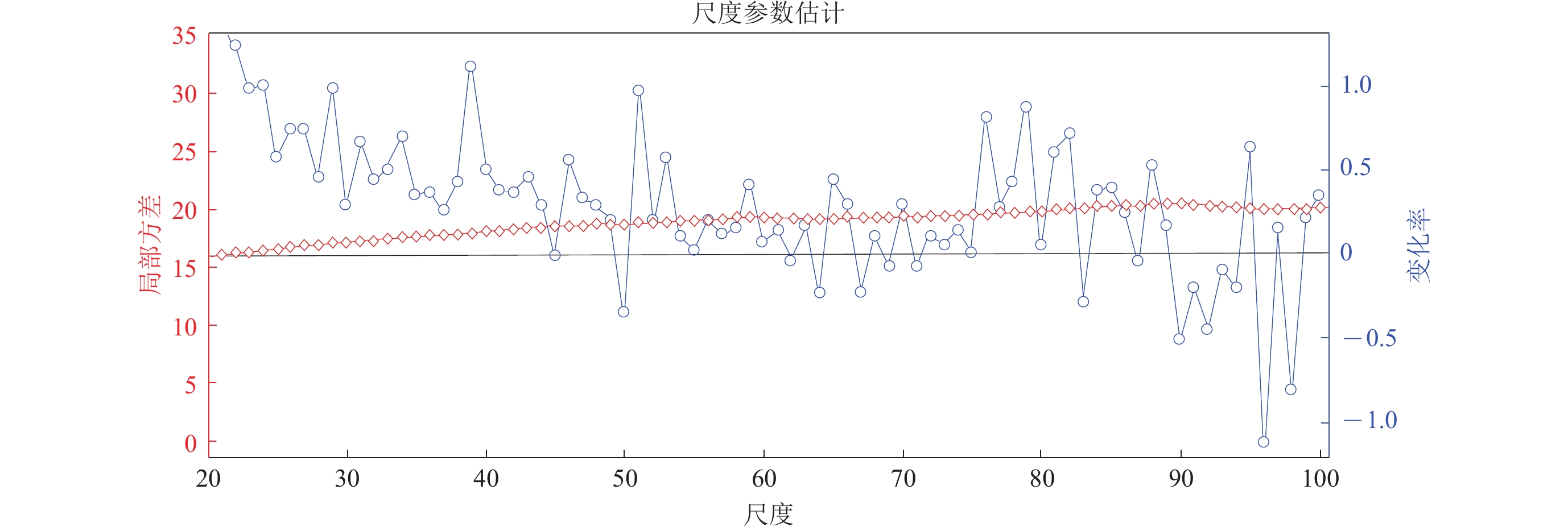
图 2 基于ESP算法的最优尺度分割评估结果
Figure 2. Evaluation results of optimal segmentation scale based on ESP algorithm
![]()
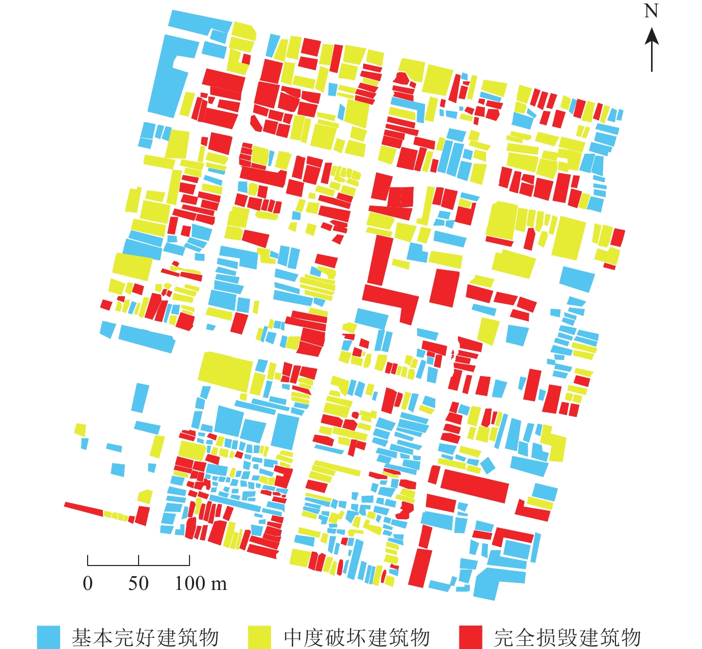
图 6 基于各种方法的“噪声”现象对比
Figure 6. Comparison of “noise” phenomena based on various methods
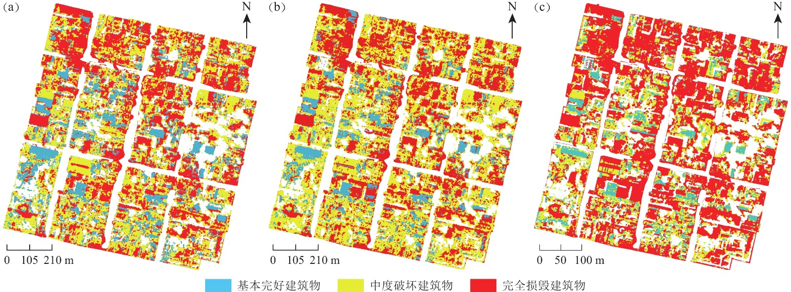
![]()
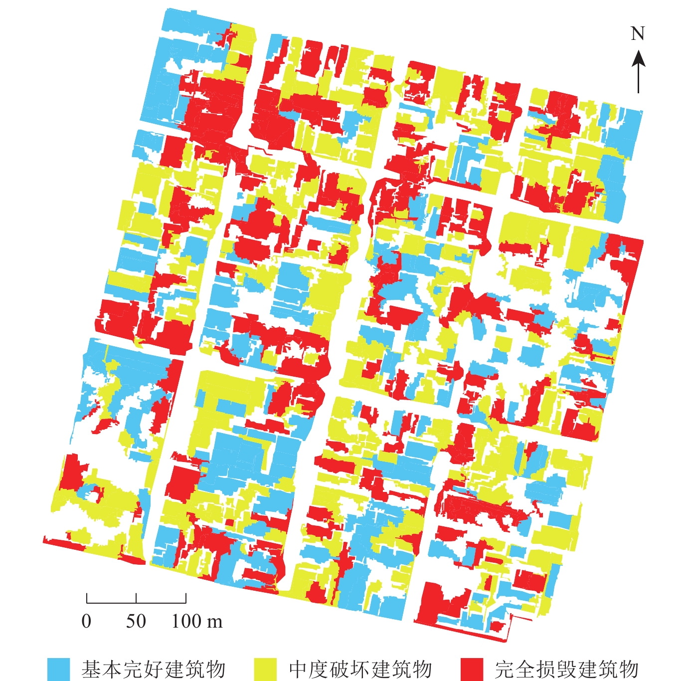
图 7 BP神经网络(a)、SVM(b)、基于CART算法决策树(c)分类结果
Figure 7. Classification results of BP neural network (a),SVM (b),decision tree based on CART algorithm method (c)
表 1 各地物的特征规则集
Table 1 The feature rule set of a variety of surface features
地物类别 特征规则集 阴影 亮度≤23 植被 均值≤30.5;矩形度≤0.9;紧致度≥1.61 完全损毁建筑物 GLCM角二阶矩≤0.002;GLCM同质性≤0.06;标准差≥30 基本完好建筑物 标准差≤12或标准差≥20;GLCM熵≥9;4.1≤GLDV熵≤4.3
1.925≤密度≤2.222或1.19≤密度≤1.39中度破坏建筑物 还未分类 注:GLCM为灰度共生矩阵,GLDV为灰度差分矢量。  下载: 导出CSV
表 2 矢量分类结果中建筑物数量
Table 2 The number of buildings achieved from the vector classification results
建筑物类型 实地调查所得数据个数 面向对象分类所得数据个数 基本完好建筑物 274 194 中度破坏建筑物 237 308 完全损毁建筑物 235 212 总计 746 714
下载: 导出CSV
表 3 各分类方法的精度评价
Table 3 Accuracy evaluation of various classification methods
方法 总体精度 Kappa系数 方法 总体精度 Kappa系数 SVM 70.37% 0.5966 基于CART算法决策树 76.22% 0.633 0 BP神经网络 74.96% 0.6537 面向对象 87.10% 0.819 3
下载: 导出CSV
表 4 各分类方法的错分率
Table 4 The error rate of various classification methods
方法 基本完好 中度破坏 完全损毁 SVM 36.73% 33.22% 18.62% BP神经网络 30.53% 30.24% 16.00% 基于CART算法决策树 37.00% 40.44% 9.08% 面向对象 20.00% 5.56% 14.29%
下载: 导出CSV
-
陈云浩,冯通,史培军,王今飞. 2006. 基于面向对象和规则的遥感影像分类研究[J]. 武汉大学学报(信息科学版),31(4):316–320. Chen Y H,Feng T,Shi P J,Wang J F. 2006. Classification of remote sensing image based on object oriented and class rules[J]. Geomatics and Information Science of Wuhan University,31(4):316–320 (in Chinese).
龚丽霞,李强,张景发,曾琪明,刘明众,李成龙. 2013. 面向对象的房屋震害变化检测方法[J]. 地震,33(2):109–114. doi: 10.3969/j.issn.1000-3274.2013.02.014 Gong L X,Li Q,Zhang J F,Zeng Q M,Liu M Z,Li C L. 2013. Object-oriented detection of earthquake building damages[J]. Earthquake,33(2):109–114 (in Chinese).
李强,张景发,龚丽霞,薛腾飞,蒋洪波. 2018. SAR图像纹理特征相关变化检测的震害建筑物提取[J]. 遥感学报,22(增刊1):128–138. Li Q,Zhang J F,Gong L X,Xue T F,Jiang H B. 2018. Extraction of earthquake-collapsed buildings based on correlation change detection of multi-texture features in SAR images[J]. Journal of Remote Sensing,22(S1):128–138 (in Chinese).
李强,张景发,罗毅,焦其松. 2019. 2017年“8.8”九寨沟地震滑坡自动识别与空间分布特征[J]. 遥感学报,23(4):785–795. Li Q,Zhang J F,Luo Y,Jiao Q S. 2019. Recognition of earthquake-induced landslide and spatial distribution patterns triggered by the Jiuzhaigou earthquake in August 8,2017[J]. Journal of Remote Sensing,23(4):785–795 (in Chinese).
牟多铎,刘磊. 2019. ELM与SVM在高光谱遥感图像监督分类中的比较研究[J]. 遥感技术与应用,34(1):115–124. Mou D D,Liu L. 2019. Comparative study of ELM and SVM in hyperspectral image supervision classification[J]. Remote Sensing Technology and Application,34(1):115–124 (in Chinese).
王东明,许立红. 2016. 破坏建筑物遥感信息提取技术:以尼泊尔8.1级地震为例[J]. 自然灾害学报,25(3):124–129. Wang D M,Xu L H. 2016. Extraction technology of remote sensing information on building damage:A case study of MS8.1 Nepal earthquake[J]. Journal of Natural Disasters,25(3):124–129 (in Chinese).
吴剑. 2010. 基于面向对象技术的遥感震害信息提取与评价方法研究[D]. 武汉: 武汉大学: 1–5. Wu J. 2010. The Research of Earthquake Information Extraction and Assessment Based on Object-Oriented Technology with Remotely-Sensed Data[D]. Wuhan: Wuhan University: 1–5 (in Chinese).
游永发,王思远,王斌,马元旭,申明,刘卫华,肖琳. 2019. 高分辨率遥感影像建筑物分级提取[J]. 遥感学报,23(1):125–136. You Y F,Wang S Y,Wang B,Ma Y X,Shen M,Liu W H,Xiao L. 2019. Study on hierarchical building extraction from high resolution remote sensing imagery[J]. Journal of Remote Sensing,23(1):125–136 (in Chinese).
张峰,薛艳丽,李英成,丁晓波. 2008. 基于SVM的多源遥感影像面向对象建筑物提取方法[J]. 国土资源遥感,47(2):27–29. Zhang F,Xue Y L,Li Y C,Ding X B. 2008. Object-oriented building extraction of multi-source remote sensing imagery based on SVM[J]. Remote Sensing for Land &Resources,47(2):27–29 (in Chinese).
张景发,李强,焦其松. 2017. 建筑物震害多源遥感特征与机理分析[J]. 地震学报,39(2):257–272. doi: 10.11939/jass.2017.02.009 Zhang J F,Li Q,Jiao Q S. 2017. Multi-source remote sensing characteristics and mechanism analyses of building seismic damages[J]. Acta Seismologica Sinica,39(2):257–272 (in Chinese).
赵萍,傅云飞,郑刘根,冯学智,Satyanarayana B. 2005. 基于分类回归树分析的遥感影像土地利用/覆被分类研究[J]. 遥感学报,9(6):708–716. doi: 10.11834/jrs.200506103 Zhao P,Fu Y F,Zheng L G,Feng X Z,Satyanarayana B. 2005. Cart-based land use/cover classification of remote sensing images[J]. Journal of Remote Sensing,9(6):708–716 (in Chinese).
赵妍. 2017. 建筑物震害遥感影像面向对象变化检测研究[D]. 北京: 中国地质大学(北京): 1–5. Zhao Y. 2017. The Research of Building Earthquake Damage Change Detection Based on Object-Oriented Technology With Remote Sensing Image[D]. Beijing: China University of Geosciences (Beijing): 1–5 (in Chinese).
Alonso-Benito A,Arroyo L A,Arbelo M,Hernández-Leal P,González-Calvo A. 2013. Pixel and object-based classification approaches for mapping forest fuel types in Tenerife Island from ASTER data[J]. Int J Wildland Fire,22(3):306–317. doi: 10.1071/WF11068
Baatz M, Schäpe A. 1999. Object-oriented and multi-scale image analysis in semantic networks[C]//Proceedings of the 2nd International Symposium on Operationalization of Remote Sensing. Enschede: 16–20.
Benediktsson J A,Swain P H,Ersoy O K. 1990. Neural network approaches versus statistical methods in classification of multisource remote sensing data[J]. IEEE Trans Geosci Remote Sens,28(4):540–550. doi: 10.1109/TGRS.1990.572944
Drăguţ L,Tiede D,Levick S R. 2010. ESP:A tool to estimate scale parameter for multiresolution image segmentation of remotely sensed data[J]. Int J Geograph Inf Sci,24(6):859–871. doi: 10.1080/13658810903174803
Drăguţ L,Csillik O,Eisank C,Tiede D. 2014. Automated parameterisation for multi-scale image segmentation on multiple layers[J]. ISPRS J Photogr Remote Sens,88:119–127. doi: 10.1016/j.isprsjprs.2013.11.018
Hussain M,Chen D M,Cheng A,Wei H,Stanley D. 2013. Change detection from remotely sensed images:From pixel-based to object-based approaches[J]. ISPRS J Photogr Remote Sens,80:91–106. doi: 10.1016/j.isprsjprs.2013.03.006
Li Q,Gong L X,Zhang J F. 2019. A correlation change detection method integrating PCA and multi-texture features of SAR image for building damage detection[J]. Eur J Remote Sens,52(1):435–447. doi: 10.1080/22797254.2019.1630322
Li X D,Yang W N,Ao T Q,Li H X,Chen W Q. 2011. An improved approach of information extraction for earthquake-damaged buildings using high-resolution imagery[J]. J Earthq Tsunami,5(4):389–399. doi: 10.1142/S1793431111001157
Gulsen T K,Musaoglu N,Ersoy O K. 2011. Damage assessment of 2010 Haiti earthquake with post-earthquake satellite image by support vector selection and adaptation[J]. Photogrammetr Eng Remote Sens,77(10):1025–1035. doi: 10.14358/PERS.77.10.1025
Turker M,Koc-San D. 2015. Building extraction from high-resolution optical spaceborne images using the integration of support vector machine (SVM) classification,hough transformation and perceptual grouping[J]. Int J Appl Earth Observ Geoinform,34:58–69. doi: 10.1016/j.jag.2014.06.016


计量
- 文章访问数: 635
- HTML全文浏览量: 325
- PDF下载量: 26
