

Characteristics of surface deformation field of Changning shale gas block in southern Sichuan basin with InSAR data
-
摘要: 近年来随着我国页岩气大规模开采,四川盆地南部活动构造相对稳定的地区出现了一系列微震和有感地震,甚至是破坏性地震。这些地震是否为工业开采所诱发,目前已有研究从时空相关性给出了一些统计推断,本文则从形变观测角度分析页岩气开采能否产生可以检测到的地面形变,以揭示形变信息与页岩气开采的关系,尝试为页岩气开采提供有效的监测手段。基于长波ALOS-2卫星雷达数据对长宁页岩气区块近两三年内的InSAR地表形变展开探测,检测页岩气大规模生产可能造成的地面形变及其基本特征,同时使用Sentinel-1卫星雷达数据分析页岩气开发活跃时段内的形变时间序列信息。结果显示:考虑到不同观测技术的误差水平和观测角度差异,两种卫星数据均反映了一致的地表形变分布,且形变场与页岩气开采井的空间分布有很好的对应关系;压裂注液过程会造成地表快速隆升,生产过程中随着流体扩散地表会出现沉降和水平运动,初步揭示出页岩气生产过程中地面形变的非稳态变形特征。这表明在四川盆地南部复杂的形变观测条件下,InSAR技术是页岩气开采有效的监测手段,能够弥补地震学观测的不足。Abstract: In recent years, along with large-scale development of shale gas, the seismicity rate has increased dramatically, a series of microseismicity, felt earthquakes and even destructive earthquakes occurred in southern Sichuan basin, a relatively tectonic stable area. Some studies statistically infer whether these earthquakes were induced by industrial activities by using spatio-temporal correlations. This study, on the other hand, uses deformation measurements to analyze whether shale gas exploitation can produce detectable surface deformation, so as to analyze the relationship between deformation and shale gas exploitation, in an attempt to find an effective approach for shale gas exploitation monitoring. Long wavelength ALOS-2 satellite radar data has the potential for minimizing decorrelation effects of radar signals caused by vegetation, heavy water vapor and topographic relief in Sichuan basin. We used ALOS-2 InSAR data to measure surface deformation in Changning shale gas block in the past two or three years, found possible ground deformation caused by massive shale gas production and analyzed its basic characteristics. Meanwhile we also processed time-series of Sentinel-1 satellite radar data to measure the surface deformation during active periods of shale gas exploitation. Considering the errors and different observation geometries of the two datasets, the results from two databases are consistent in revealing the surface deformation. Furthermore, the meaured deformation field is in agreement with the spatial distribution of shale gas wells. Our observations show fast surface uplift during hydrofracture injection, also ground subsidence and horizontal motion in production period with fliud diffusion. We preliminarily reveal the non-steady deformation characteristics during shale gas production. Our study suggests that InSAR is an effective technique for shale gas production monitoring even in southern Sichuan basin where complex deformation occurs, and can provide insights supplementary for seismological observations.
-
Keywords:
- shale gas exploitation /
- differential interferometry /
- ALOS-2 /
- PS-InSAR
-
-
![]()
图 4 大气对流层延迟校正及长波趋势相位校正
(a,b) 基于ERA5模型去除升、降轨对流层延迟误差后的图像;(c,d) 长波趋势相位校正后的图像,其中蓝色方框表示本研究的形变区
Figure 4. Atmospheric troposphere delay correction and long wavelength trend phase correction
(a,b) Images after removing tropospheric delay errors in ascending and descending orbits based on the ERA5 model, respectively;(c,d) Images after long wavelength trend phase correction,where blue boxes denote the deformation area of this study
![]()
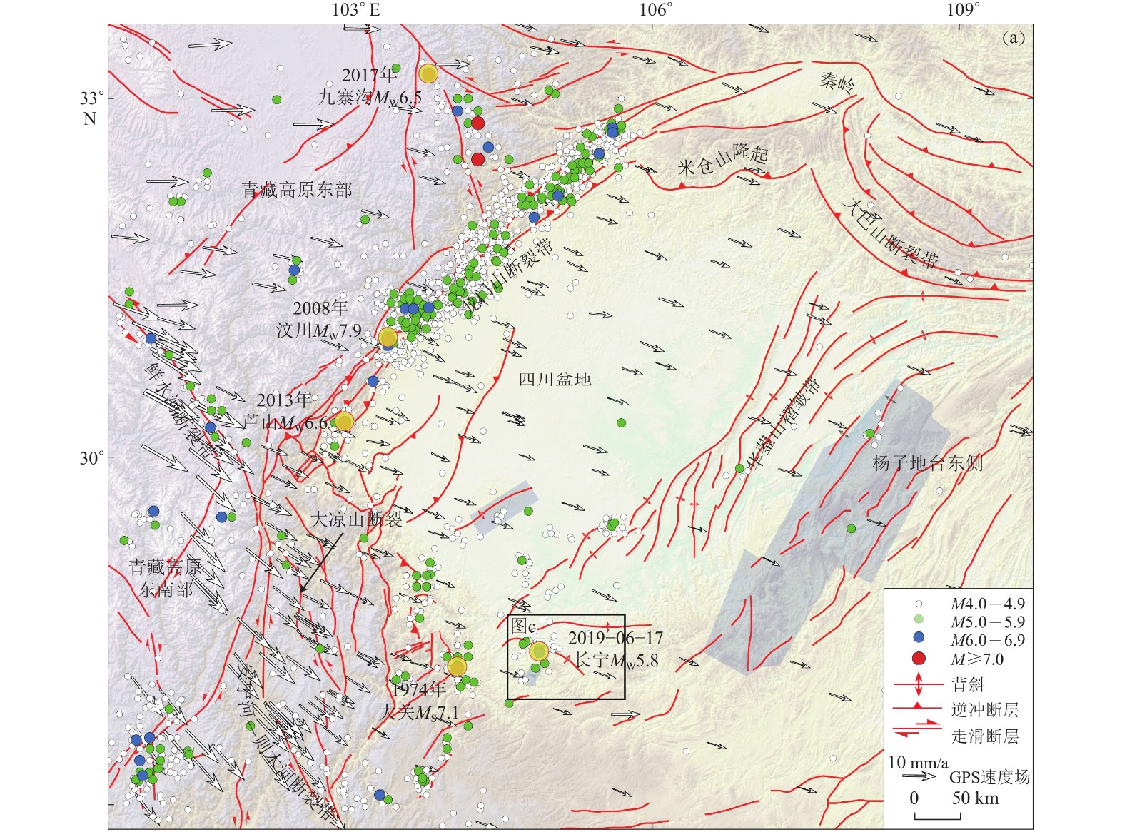
图 1 四川盆地构造背景及地震活动性时空分布
(a) 四川盆地地震构造和1970年之后的地震分布,地震目录数据来源于国家地震科学数据中心(2021),GPS数据来源于Wang和Shen (2020)
Figure 1. Tectonic settings of Sichuan basin and spatio-temporal distribution of its seismicity
(a) Seismotectonics of Sichuan basin and earthquake distribution since 1970,where earthquake catalog from National Earthquake Data Center (2021),GPS data from Wang and Shen (2020)
![]()
图 1 四川盆地构造背景及地震活动性时空分布
(b) 2009年以来威远和长宁地区地震的空间分布及M4以上地震的震源机制解(GCMT,2021),其中红色震源机制球代表疑似采盐注水引起的地震事件,蓝色代表疑似水力压裂引起的事件,黑色代表天然地震;(c) 长宁页岩气开采区块附近褶皱迹线和地表断层分布;(d) 2009年以来长宁区块M>0地震的时间演化图
Figure 1. Tectonic settings of Sichuan basin and spatio-temporal distribution of its seismicity
(b) Spatial distribution of earthquakes in Weiyuan and Changning areas since 2009 and focal mechanisms of earthquakes larger than M4 (GCMT,2021),where red beach balls represent seismic events suspected to be caused by water injection and salt extraction,blue ones represent events suspected to be caused by hydraulic fracturing,and black ones represent natural earthquakes;(c) Fold traces and surface faults around Changning shale gas block. Solid black lines are Changning anticline and Jianwu syncline;(d) Evolution of M>0 earthquakes in Changning block since 2009
![]()
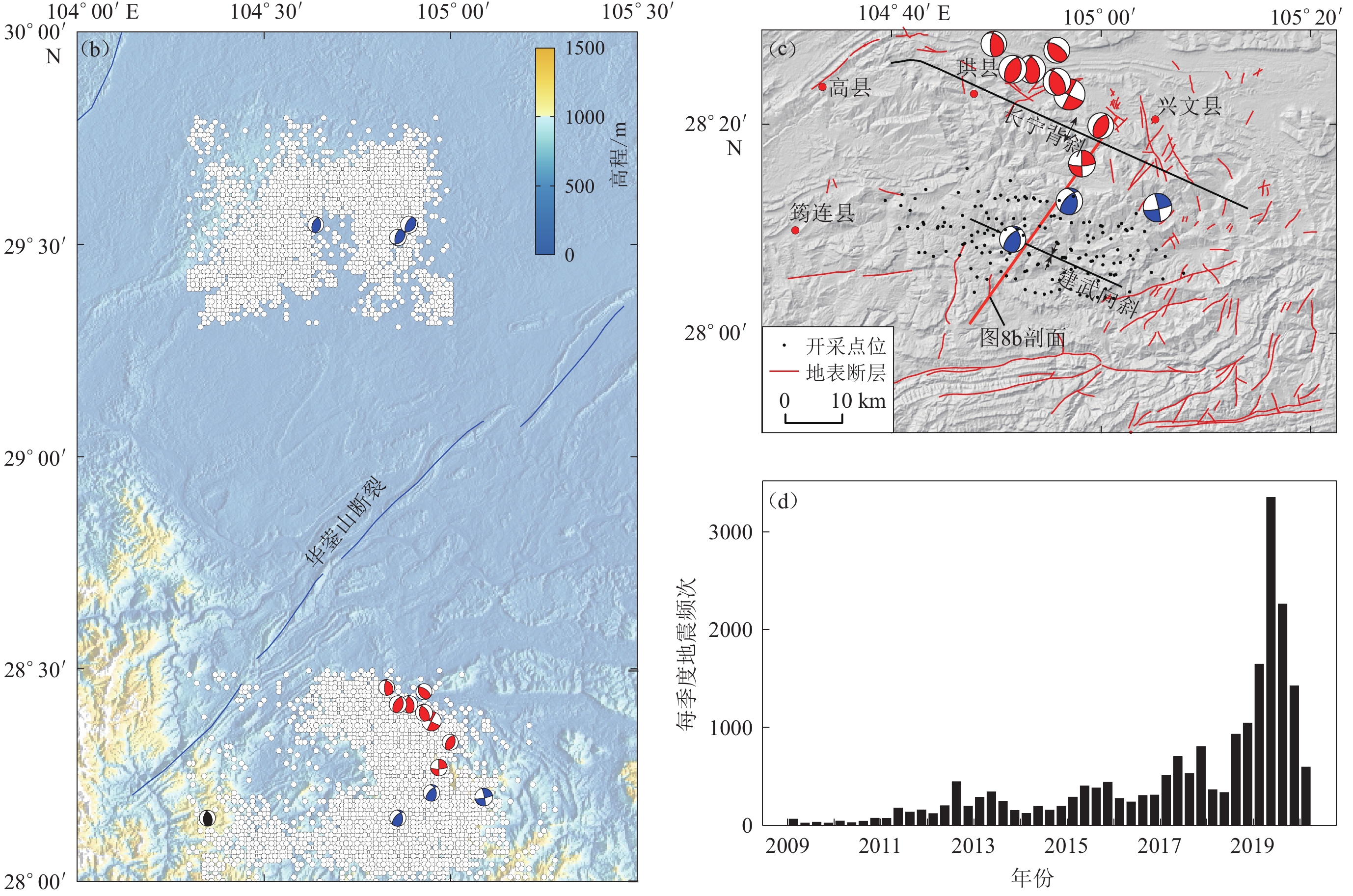
图 2 功率谱滤波后的ALOS-2差分干涉相位结果
(a) 升轨ScanSAR模式差分干涉图,成像时间为2016年8月7日至2019年9月15日;(b) 降轨StripMap模式差分干涉图,成像时间为2017年6月12日至2019年7月8日
Figure 2. ALOS-2 differential interferometry phases with power spectrum filtering
(a) Differential interferogram in ascending orbit with ScanSAR mode,imaging from August 7,2016 to September 15,2019; (b) Differential interferogram in descending orbit with StripMap mode,imaging from June 12,2017 to July 8,2019
![]()
图 3 利用距离向信号频谱分割法估计电离层延迟相位
(a) 升轨ScanSAR模式图像的电离层相位估计结果;(b) 降轨StripMap模式图像的电离层相位估计结果;(c) 升轨ScanSAR模式图像去除电离层相位的缠绕相位;(d) 降轨StripMap模式图像去除电离层相位的缠绕相位
Figure 3. Estimation of the ionospheric phase delay by range split-spectrum method
(a) Ionospheric phase estimated from ascending orbit image with ScanSAR mode;(b) Ionospheric phase estimated from descending orbit image with StripMap mode;(c) Wrapped phase estimated from ascending orbit image with ScanSAR mode after removing ionospheric phase;(d) Wrapped phase estimated from descending orbit image with StripMap mode after removing ionospheric phase
![]()
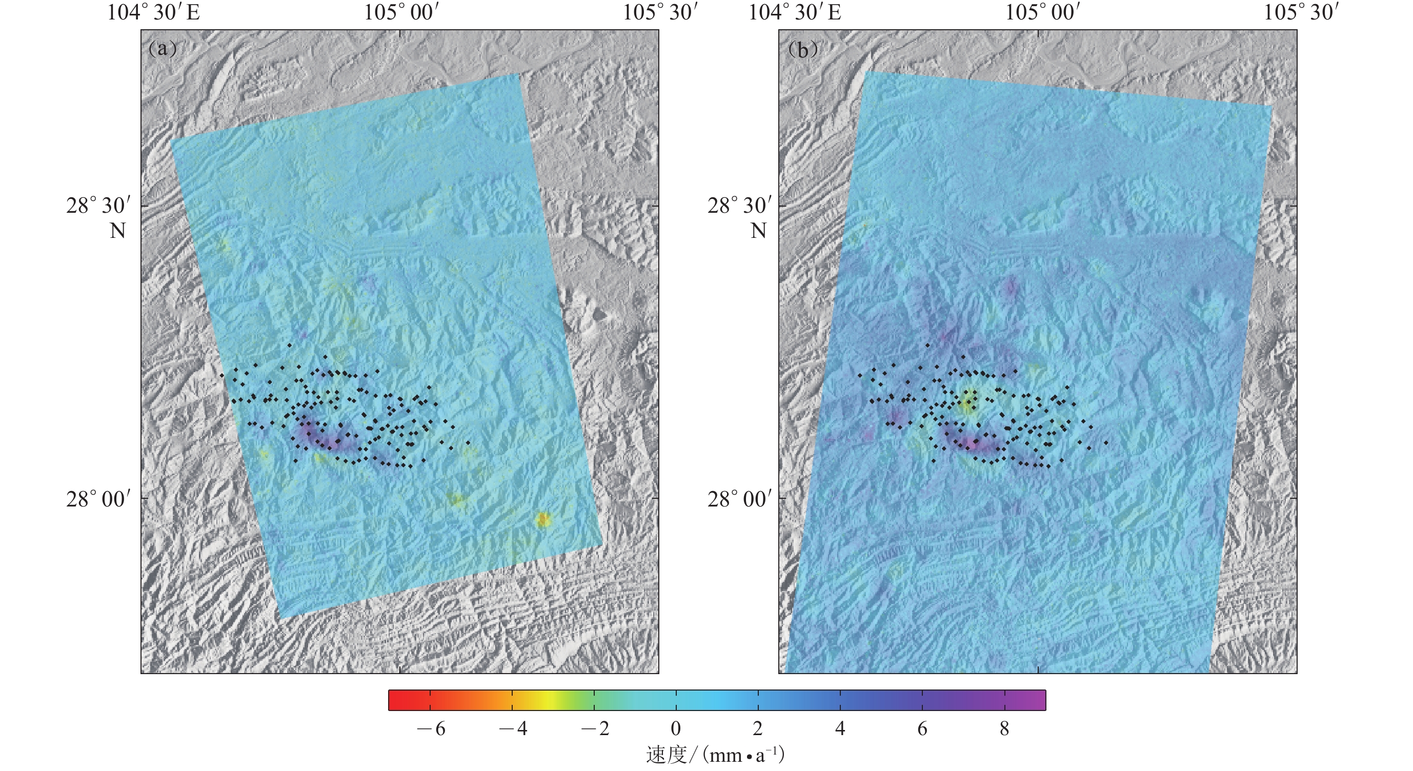
图 5 基于长宁页岩气开发区Sentinel-1雷达数据得到的升轨(a)和降轨(b) PS-InSAR线性速度场
图中黑点表示该区块中已知页岩气井的空间分布
Figure 5. PS-InSAR linear velocity field in ascending (a) and descending (b) orbits obtained from Sentinel-1 radar data around Changning shale gas block
The black dots indicate spatial distribution of known shale gas wells in Changning shale gas block
![]()
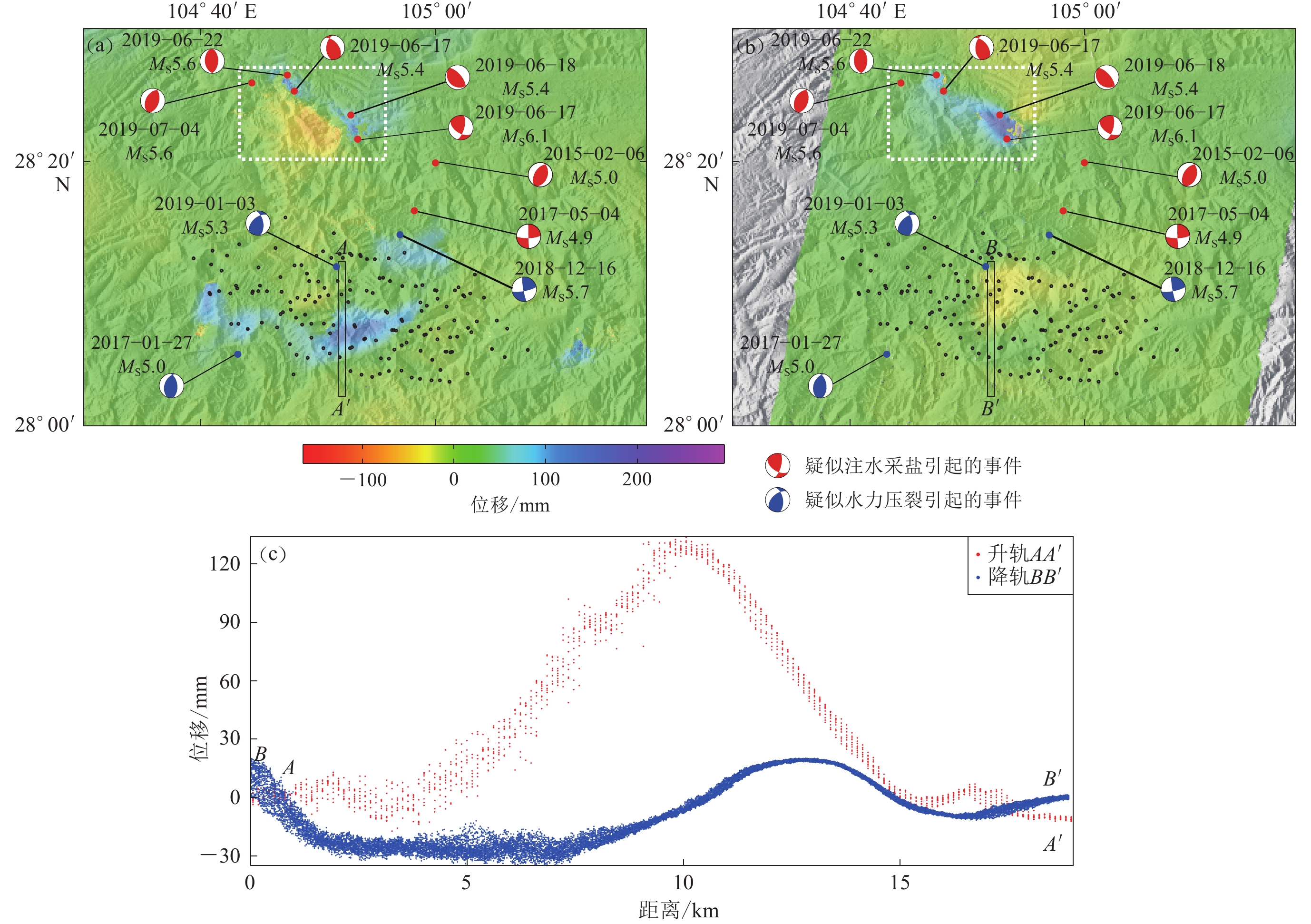
图 6 长宁页岩气区块近场ALOS-2干涉形变位移场及剖面图
长宁地震序列和水力压裂致震的震源机制解来源于Lei等(2019a),其余2015年和2017年的两次地震的震源机制解来源于GCMT (2021);白色虚线框表示2019年6月17日长宁地震形变场(a) 升轨ScanSAR模式图像得到的页岩气区块形变位移场,成像间隔为3年;(b) 降轨StripMap模式图像得到的页岩气区块形变位移场,成像间隔为2年;(c) 图(a)中的AA′和图(b)中的BB′形变位移场剖面,两剖面在同一位置
Figure 6. ALOS-2 interferometry displacement field and profiles in the near field of Changning shale gas block
The focal mechanism solution of the Changning earthquake sequence and hydraulic fracturing are from Lei et al (2019a),the remaining two earthquakes in 2015 and 2017 are from GCMT (2021). The white dashed box represents the deformation field of the Changning earthquake occurred on June 17,2019 (a) Deformation displacement field of shale gas block obtained from ascending orbit data in ScanSAR mode,and the imaging interval is three years;(b) Deformation displacement field of shale gas block obtained from descending orbit data in StripMap mode,and the imaging interval is two years; (c) Deformation displacements on the profiles AA′ in Fig. (a) and BB′ in Fig. (b),and the two profiles are at the same location
![]()
图 7 长宁页岩气区块近场升降轨Sentinel-1数据的LOS向线性速度场
图(a)和(b)中KK′为图8a中二维地震反射剖面位置,OO′为图8b中断层破碎带的北界;图(c)中红色直线为线性速度模型拟合的各点位移。(a) 升轨速度场;(b) 降轨速度场;(c) 图(a)和图(b)中P1,P2,P3和P4点的位移时间序列;(d) 升轨数据剖面CC′和降轨数据剖面DD′上的形变速率变化
Figure 7. Linear velocity field of Sentinel-1 data in LOS direction in the near field of Changning shale gas block
In Figs. (a) and (b) KK′ is the location of the two-dimensional seismic reflection profile in Fig. 8a,and OO′ is the north boundary of a fault fracture zone in Fig. 8b;in Fig. (c) the red straight lines are the displacements of each point by linear velocity fitting. (a) Velocity field in ascending orbit;(b) Velocity field in descending orbit;(c) The displacement time series of points P1,P2,P3 and P4 in Figs. (a) and (b),respectively;(d) Variation of deformation rates on the profile CC′ in ascending orbit and profile DD′ in descending orbit
![]()
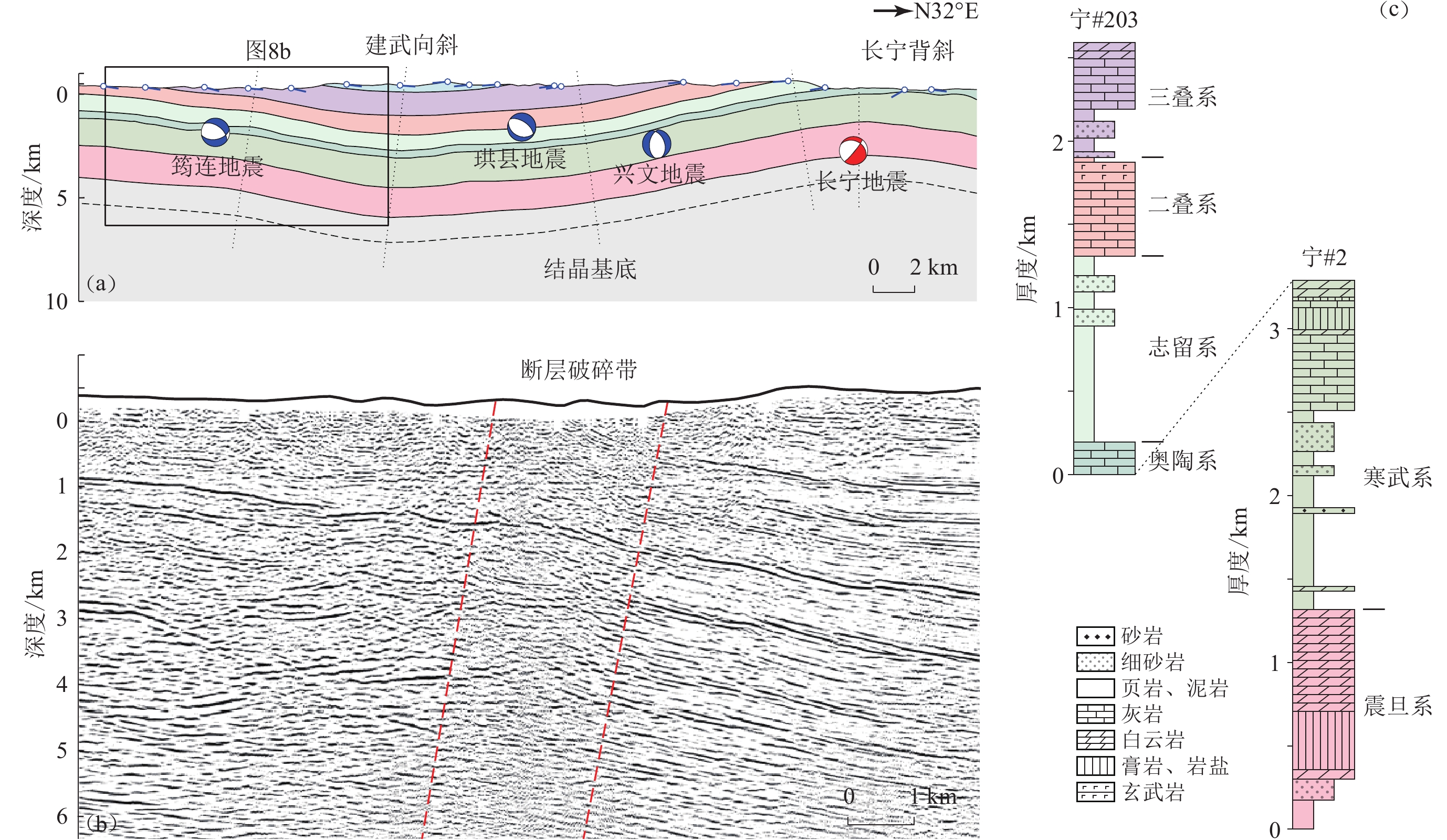
图 8 跨越长宁开采区的二维地震反射剖面
(a) KK′剖面(图7)对应的地层结构和近年来长宁附近发生的较大地震事件及其震源机制解(Li et al,2021);(b) 图7d形变剖面中15—17 km处断层破碎带附近的二维地震反射剖面,其位置见图1c;(c) 长宁地区的沉积地层序列(Li et al,2021)
Figure 8. Two-dimensional seismic reflection profile across the Changning shale gas block
(a) The stratigraphic structure corresponding to the profile KK′ (Fig. 7) and several large-magnitude events near Changning area in recent years and their focal mechanism solutions (Li et al,2021);(b) The two-dimensional seismic reflection profile near a fault fracture zone at 15−17 km of the deformation profile in Fig. 7d,and the location of the profile is shown in Fig. 1c;(c) Sedimentary stratigraphic sequence in Changning area (Li et al,2021)
![]()
图 9 MS≥5.0地震引起的地表形变与页岩气开采区形变的关系
(a) 2017年6月12日至2019年7月8日期间的ALOS-2降轨页岩气区块形变场,图中矩形A和B分别为珙县地震和兴文地震引起的地表形变,区域C为页岩气开采引起的地表形变,地震定位结果来自Lei等(2019b),H18井位置源于本研究实地野外调查;(b) 2018年12月30日至2019年1月11日期间的Sentinel-1 LOS向InSAR形变图
Figure 9. The relationship between the surface deformation caused by the MS≥5.0 earthquakes and the deformation of shale gas exploitation
(a) ALOS-2 descending deformation field of shale gas block from June 12,2017 to July 8,2019,where the rectangles A and B are the surface deformation caused by the Gongxian and Xingwen earthquakes,C is the surface deformation caused by shale gas exploitation,earthquake location results are from Lei et al (2019b),and the location of well H18 is from our field investigation; (b) Sentinel-1 LOS InSAR deformation map from December 30,2018 to January 11,2019
表 1 本研究所用ALOS-2 PALSAR数据的参数
Table 1 ALOS-2 PALSAR data parameters used in this study
主景日期 从景日期 入射角/° 卫星方向角/° 轨道 垂直基线/m 2016-08-07 2019-09-15 39 −10.2 升轨(146) 75.7 2017-06-12 2019-07-08 40 −169.9 降轨(37) −27.6  下载: 导出CSV
-
陈朝伟,宋毅,青春,杨扬,项德贵. 2019. 四川长宁页岩气水平井压裂套管变形实例分析[J]. 地下空间与工程学报,15(2):513–524. Chen Z W,Song Y,Qing C,Yang Y,Xiang D G. 2019. A case study on casing deformation of horizontal well during hydraulic fracturing in Sichuan Changning[J]. Chinese Journal of Underground Space and Engineering,15(2):513–524 (in Chinese).
董大忠,高世葵,黄金亮,管全中,王淑芳,王玉满. 2014. 论四川盆地页岩气资源勘探开发前景[J]. 天然气工业,34(12):1–15. Dong D Z,Gao S K,Huang J L,Guan Q Z,Wang S F,Wang Y M. 2014. A discussion on the shale gas exploration & development prospect in the Sichuan basin[J]. Natural Gas Industry,34(12):1–15 (in Chinese).
国家地震科学数据中心. 2021. 中国台网正式目录[EB/OL]. [2021-03-14]. https://data.earthquake.cn/datashare/report.shtml?PAGEID=earthquake_zhengshi. National Earthquake Data Center. 2021. Official catalog of China channel network[EB/OL]. [2021-03-14]. https://data.earthquake.cn/datashare/report.shtml?PAGEID=earthquake_zhengshi (in Chinese).
韩慧芬,贺秋云,王良. 2017. 长宁区块页岩气井排液技术现状及攻关方向探讨[J]. 钻采工艺,40(4):69–71. doi: 10.3969/J.ISSN.1006-768X.2017.04.22 Han H F,He Q Y,Wang L. 2017. The current situation of flowback technology and its further development research for shale-gas wells in Changning block[J]. Drilling &Production Technology,40(4):69–71 (in Chinese).
何登发,鲁人齐,黄涵宇,王晓山,姜华,张伟康. 2019. 长宁页岩气开发区地震的构造地质背景[J]. 石油勘探与开发,46(5):993–1006. doi: 10.11698/PED.2019.05.19 He D F,Lu R Q,Huang H Y,Wang X S,Jiang H,Zhang W K. 2019. Tectonic and geological background of the earthquake hazards in Changning shale gas development zone,Sichuan basin,SW China[J]. Petroleum Exploration and Development,46(5):993–1006 (in Chinese).
蒲泊伶,蒋有录,王毅,包书景,刘鑫金. 2010. 四川盆地下志留统龙马溪组页岩气成藏条件及有利地区分析[J]. 石油学报,31(2):225–230. doi: 10.7623/syxb201002008 Pu B L,Jiang Y L,Wang Y,Bao S J,Liu X J. 2010. Reservoir-forming conditions and favorable exploration zones of shale gas in Lower Silurian Longmaxi formation of Sichuan basin[J]. Acta Petrolei Sinica,31(2):225–230 (in Chinese).
任勇,钱斌,张剑,卓智川,乔琳. 2015. 长宁地区龙马溪组页岩气工厂化压裂实践与认识[J]. 石油钻采工艺,37(4):96–99. Ren Y,Qian B,Zhang J,Zhuo Z C,Qiao L. 2015. Practice and understanding of industrial fracturing for shale gas of Longmaxi formation in Changning region[J]. Oil Drilling &Production Technology,37(4):96–99 (in Chinese).
阮祥,程万正,张永久,李军,陈银. 2008. 四川长宁盐矿井注水诱发地震研究[J]. 中国地震,24(3):226–234. doi: 10.3969/j.issn.1001-4683.2008.03.004 Ruan X,Cheng W Z,Zhang Y J,Li J,Chen Y. 2008. Research of the earthquakes induced by water injections in salt mines in Changning,Sichuan[J]. Earthquake Research in China,24(3):226–234 (in Chinese).
孙广通,张永红,吴宏安. 2011. 合成孔径雷达干涉测量大气改正研究综述[J]. 遥感信息,(4):111–116. doi: 10.3969/j.issn.1000-3177.2011.04.022 Sun G T,Zhang Y H,Wu H A. 2011. Review of atmospheric correction methods for interferometric synthetic aperture radar measurements[J]. Remote Sensing Information,(4):111–116 (in Chinese).
王楠,付海洋,李索,徐丰. 2017. 基于频带分割法反演电离层TEC参数[J]. 太赫兹科学与电子信息学报,15(2):198–205. doi: 10.11805/TKYDA201702.0198 Wang N,Fu H Y,Li S,Xu F. 2017. Retrieving ionospheric TEC based on the split-spectrum method[J]. Journal of Terahertz Science and Electronic Information Technology,15(2):198–205 (in Chinese).
易桂喜,龙锋,梁明剑,赵敏,王思维,宫悦,乔慧珍,苏金蓉. 2019. 2019年6月17日四川长宁MS6.0地震序列震源机制解与发震构造分析[J]. 地球物理学报,62(9):3432–3447. doi: 10.6038/cjg2019N0297 Yi G X,Long F,Liang M J,Zhao M,Wang S W,Gong Y,Qiao H Z,Su J R. 2019. Focal mechanism solutions and seismogenic structure of the 17 June 2019 MS6.0 Sichuan Changning earthquake sequence[J]. Chinese Journal of Geophysics,62(9):3432–3447 (in Chinese).
张捷,况文欢,张雄,莫程康,张东晓. 2021. 全球油气开采诱发地震的研究现状与对策[J]. 地球与行星物理论评,52(3):239–265. Zhang J,Kuang W H,Zhang X,Mo C K,Zhang D X. 2021. Global review of induced earthquakes in oil and gas production fields[J]. Reviews of Geophysics and Planetary Physics,52(3):239–265 (in Chinese).
周洪月. 2018. 时序InSAR矿区地表形变监测中的大气延迟校正研究[D]. 北京: 中国矿业大学: 5–6. Zhou H Y. 2018. Study on Atmospheric Delay Correction of InSAR Time Series to Detect Ground Subsidence in Mining Area[D]. Beijing: China University of Mining and Technology: 5–6 (in Chinese).
朱航,何畅. 2014. 注水诱发地震序列的震源机制变化特征:以四川长宁序列为例[J]. 地球科学:中国地质大学学报,39(12):1776–1782. Zhu H,He C. 2014. Focal mechanism character of earthquake sequence induced by water injection:A case study of Changning sequence,Sichuan Province[J]. Earth Science:Journal of China University of Geosciences,39(12):1776–1782 (in Chinese). doi: 10.3799/dqkx.2014.161
Atkinson G M,Eaton D W,Ghofrani H,Walker D,Cheadle B,Schultz R,Shcherbakov R,Tiampo K,Gu J,Harrington R M,Liu Y J,van der Baan M,Kao H. 2016. Hydraulic fracturing and seismicity in the western Canada sedimentary basin[J]. Seismol Res Lett,87(3):631–647. doi: 10.1785/0220150263
Bao X W,Eaton D W. 2016. Fault activation by hydraulic fracturing in western Canada[J]. Science,354(6318):1406–1409. doi: 10.1126/science.aag2583
Barbour A J,Evans E L,Hickman S H,Eneva M. 2016. Subsidence rates at the southern Salton sea consistent with reservoir depletion[J]. J Geophys Res:Solid Earth,121(7):5308–5327. doi: 10.1002/2016JB012903
Bekaert D P S,Walters R J,Wright T J,Hooper A J,Parker D J. 2015. Statistical comparison of InSAR tropospheric correction techniques[J]. Remote Sens Environ,170:40–47. doi: 10.1016/j.rse.2015.08.035
Brcic R, Parizzi A, Eineder M, Bamler R, Meyer F. 2010. Estimation and compensation of ionospheric delay for SAR interferometry[C]//Proceedings of 2010 IEEE International Geoscience and Remote Sensing Symposium. Honolulu: IEEE: 2908–2911.
Burchfiel B C,Chen Z L,Liu Y,Royden L H. 1995. Tectonics of the Longmen shan and adjacent regions,central China[J]. Int Geol Rev,37(8):661–735. doi: 10.1080/00206819509465424
Comola F,Janna C,Lovison A,Minini M,Tamburini A,Teatini P. 2016. Efficient global optimization of reservoir geomechanical parameters based on synthetic aperture radar-derived ground displacements[J]. Geophysics,81(3):M23–M33. doi: 10.1190/geo2015-0402.1
Deng F H,Dixon T H,Xie S R. 2020. Surface deformation and induced seismicity due to fluid injection and oil and gas extraction in western Texas[J]. J Geophys Res:Solid Earth,125(5):e2019JB018962.
Deng K,Liu Y J,Harrington R M. 2016. Poroelastic stress triggering of the December 2013 Crooked Lake,Alberta,induced seismicity sequence[J]. Geophys Res Lett,43(16):8482–8491. doi: 10.1002/2016GL070421
Doin M P,Lasserre C,Peltzer G,Cavalié O,Doubre C. 2009. Corrections of stratified tropospheric delays in SAR interferometry:Validation with global atmospheric models[J]. J Appl Geophys,69(1):35–50. doi: 10.1016/j.jappgeo.2009.03.010
Ebmeier S K, Biggs J, Mather T A, Amelung F. 2013. Applicability of InSAR to tropical volcanoes: Insights from central America[J]. Geol Soc London Spec Publ, 380(1): 15–37.
Ferretti A,Prati C,Rocca F. 2000. Nonlinear subsidence rate estimation using permanent scatterers in differential SAR interferometry[J]. IEEE Trans Geosci Remote Sens,38(5):2202–2212. doi: 10.1109/36.868878
Ferretti A,Prati C,Rocca F. 2001. Permanent scatterers in SAR interferometry[J]. IEEE Trans Geosci Remote Sens,39(1):8–20. doi: 10.1109/36.898661
GCMT. 2021. Global CMT catalog search[EB/OL]. [2021-03-23]. https://www.globalcmt.org/CMTsearch.html.
Goebel T H W,Brodsky E E. 2018. The spatial footprint of injection wells in a global compilation of induced earthquake sequences[J]. Science,361(6405):899–904. doi: 10.1126/science.aat5449
Gomba G,Parizzi A,de Zan F,Eineder M,Bamler R. 2016. Toward operational compensation of ionospheric effects in SAR interferograms:The split-spectrum method[J]. IEEE Trans Geosci Remote Sens,54(3):1446–1461. doi: 10.1109/TGRS.2015.2481079
Hanssen R F. 2001. Radar Interferometry: Data Interpretation and Error Analysis[M]. Dordrecht: Springer: 66–69.
Hooper A,Zebker H,Segall P,Kampes B. 2004. A new method for measuring deformation on volcanoes and other natural terrains using InSAR persistent scatterers[J]. Geophys Res Lett,31(23):L23611.
Hooper A,Segall P,Zebker H. 2007. Persistent scatterer interferometric synthetic aperture radar for crustal deformation analysis,with application to Volcán Alcedo,Galápagos[J]. J Geophys Res:Solid Earth,112(B7):B07407.
Hu Z B,Mallorquí J J. 2019. An accurate method to correct atmospheric phase delay for InSAR with the ERA5 global atmospheric model[J]. Remote Sens,11(17):1969. doi: 10.3390/rs11171969
Jackson R B,Vengosh A,Carey J W,Davies R J,Darrah T H,O’sullivan F,Pétron G. 2014. The environmental costs and benefits of fracking[J]. Annu Rev Environ Resour,39:327–362. doi: 10.1146/annurev-environ-031113-144051
Jiang S,Peng Y M,Gao B,Zhang J C,Cai D S,Xue G,Bao S J,Xu Z Y,Tang X L,Dahdah N. 2016. Geology and shale gas resource potentials in the Sichuan basin,China[J]. Energy Explor Exploit,34(5):689–710. doi: 10.1177/0144598716657442
Jordan C,Bateson L,Novellino A. 2019. Environmental baseline monitoring for shale-gas development:Insights for monitoring ground motion using InSAR analysis[J]. Sci Total Environ,696:134075. doi: 10.1016/j.scitotenv.2019.134075
Keranen K M,Weingarten M. 2018. Induced seismicity[J]. Annu Rev Earth Planet Sci,46:149–174. doi: 10.1146/annurev-earth-082517-010054
Kubanek J, Liu Y J, Harrington R M, Samsonov S. 2018. Observation of surface deformation associated with hydraulic fracturing in western Canada using InSAR[C]//Proceedings of the EUSAR 2018; 12th European Conference on Synthetic Aperture Radar. Aachen: IEEE: 1–6.
Lei X L,Wang Z W,Su J R. 2019a. Possible link between long-term and short-term water injections and earthquakes in salt mine and shale gas site in Changning,south Sichuan basin,China[J]. Earth Planet Phys,3(6):510–525. doi: 10.26464/epp2019052
Lei X L,Wang Z W,Su J R. 2019b. The December 2018 ML5.7 and January 2019 ML5.3 earthquakes in south Sichuan basin induced by shale gas hydraulic fracturing[J]. Seismol Res Lett,90(3):1099–1110. doi: 10.1785/0220190029
Lei X L,Su J R,Wang Z W. 2020. Growing seismicity in the Sichuan basin and its association with industrial activities[J]. Science China Earth Science,63(11):1633–21660. doi: 10.1007/s11430-020-9646-x
Lei X L,Yu G Z,Ma S L,Wen X Z,Wang Q. 2008. Earthquakes induced by water injection at ~3 km depth within the Rongchang gas field,Chongqing,China[J]. J Geophys Res:Solid Earth,113(B10):B10310. doi: 10.1029/2008JB005604
Lei X L,Ma S L,Chen W K,Pang C M,Zeng J,Jiang B. 2013. A detailed view of the injection-induced seismicity in a natural gas reservoir in Zigong,southwestern Sichuan basin,China[J]. J Geophys Res:Solid Earth,118(8):4296–4311. doi: 10.1002/jgrb.50310
Lei X L,Huang D J,Su J R,Jiang G M,Wang X L,Wang H,Guo X,Fu H. 2017. Fault reactivation and earthquakes with magnitudes of up to MW4.7 induced by shale-gas hydraulic fracturing in Sichuan basin,China[J]. Sci Rep,7(1):7971. doi: 10.1038/s41598-017-08557-y
Li T,Sun J B,Bao Y X,Zhan Y,Shen Z K,Xu X W,Lasserre C. 2021. The 2019 MW5.8 Changning,China earthquake:A cascade rupture of fold-accommodation faults induced by fluid injection[J]. Tectonophysics,801:228721. doi: 10.1016/j.tecto.2021.228721
Liang C R,Fielding E J. 2017. Measuring azimuth deformation with L-band ALOS-2 ScanSAR interferometry[J]. IEEE Trans Geosci Remote Sens,55(5):2725–2738. doi: 10.1109/TGRS.2017.2653186
Liang C R,Liu Z,Fielding E J,Bürgmann R. 2018. InSAR time series analysis of L-band wide-swath SAR data acquired by ALOS-2[J]. IEEE Trans Geosci Remote Sens,56(8):4492–4506. doi: 10.1109/TGRS.2018.2821150
Liu J Q,Zahradník J. 2020. The 2019 MW5.7 Changning earthquake,Sichuan basin,China:A shallow doublet with different faulting styles[J]. Geophys Res Lett,47(4):e2019GL085408.
Lohman R B,Simons M. 2005. Some thoughts on the use of InSAR data to constrain models of surface deformation:Noise structure and data downsampling[J]. Geochem Geophys Geosyst,6(1):Q01007.
Meng L Y,McGarr A,Zhou L Q,Zang Y. 2019. An investigation of seismicity induced by hydraulic fracturing in the Sichuan basin of China based on data from a temporary seismic network[J]. Bull Seismol Soc Am,109(1):348–357. doi: 10.1785/0120180310
Norris J Q,Turcotte D L,Moores E M,Brodsky E E,Rundle J B. 2016. Fracking in tight shales:What is it,what does it accomplish,and what are its consequences?[J]. Annu Rev Earth Planet Sci,44:321–351. doi: 10.1146/annurev-earth-060115-012537
Parker A L,Biggs J,Walters R J,Ebmeier S K,Wright T J,Teanby N A,Lu Z. 2015. Systematic assessment of atmospheric uncertainties for InSAR data at volcanic arcs using large-scale atmospheric models:Application to the Cascade volcanoes,United States[J]. Remote Sens Environ,170:102–114. doi: 10.1016/j.rse.2015.09.003
Rosen P A, Hensley S, Chen C. 2010. Measurement and mitigation of the ionosphere in L-band interferometric SAR data[C]//Proceedings of 2010 IEEE Radar Conference. Arlington: IEEE: 1459−1463.
Sandwell D T,Myer D,Mellors R,Shimada M,Brooks B,Foster J. 2008. Accuracy and resolution of ALOS interferometry:Vector deformation maps of the Father’s day intrusion at Kilauea[J]. IEEE Trans Geosci Remote Sens,46(11):3524–3534. doi: 10.1109/TGRS.2008.2000634
Schultz R,Wang R J,Gu Y J,Haug K,Atkinson G. 2017. A seismological overview of the induced earthquakes in the Duvernay play near Fox Creek,Alberta[J]. J Geophys Res:Solid Earth,122(1):492–505. doi: 10.1002/2016JB013570
Schultz R,Skoumal R J,Brudzinski M R,Eaton D,Baptie B,Ellsworth W. 2020. Hydraulic fracturing‐induced seismicity[J]. Rev Geophys,58(3):e2019RG000695.
Shen Z K,Sun J B,Zhang P Z,Wan Y G,Wang M,Bürgmann R,Zeng Y H,Gan W J,Liao H,Wang Q L. 2009. Slip maxima at fault junctions and rupturing of barriers during the 2008 Wenchuan earthquake[J]. Nat Geosci,2(10):718–724. doi: 10.1038/ngeo636
Shirzaei M,Manga M,Zhai G. 2019. Hydraulic properties of injection formations constrained by surface deformation[J]. Earth Planet Sci Lett,515:125–134. doi: 10.1016/j.jpgl.2019.03.025
Sun X L,Yang P T,Zhang Z W. 2017. A study of earthquakes induced by water injection in the Changning salt mine area,SW China[J]. J Asian Earth Sci,136:102–109. doi: 10.1016/j.jseaes.2017.01.030
Tan Y Y,Hu J,Zhang H J,Chen Y K,Qian J W,Wang Q F,Zha H S,Tang P,Nie Z. 2020. Hydraulic fracturing induced seismicity in the southern Sichuan basin due to fluid diffusion inferred from seismic and injection data analysis[J]. Geophys Res Lett,47(4):e2019GL084885.
Tian Y T,Kohn B P,Qiu N S,Yuan Y S,Hu S B,Gleadow A J W,Zhang P Z. 2018. Eocene to Miocene out-of-sequence deformation in the eastern Tibetan Plateau:Insights from shortening structures in the Sichuan basin[J]. J Geophys Res:Solid Earth,123(2):1840–1855. doi: 10.1002/2017JB015049
Vasco D W,Rucci A,Ferretti A,Novali F,Bissell R C,Ringrose P S,Mathieson A S,Wright I W. 2010. Satellite-based measurements of surface deformation reveal fluid flow associated with the geological storage of carbon dioxide[J]. Geophys Res Lett,37(3):L03303.
Wang E,Meng K,Su Z,Meng Q R,Chu J J,Chen Z L,Wang G,Shi X H,Liang X Q. 2014. Block rotation:Tectonic response of the Sichuan basin to the southeastward growth of the Tibetan Plateau along the Xianshuihe‐Xiaojiang fault[J]. Tectonics,33(5):686–718. doi: 10.1002/2013TC003337
Wang M,Shen Z K. 2020. Present‐day crustal deformation of continental China derived from GPS and its tectonic implications[J]. J Geophys Res:Solid Earth,125(2):e2019JB018774.
Wang S,Jiang G Y,Weingarten M,Niu Y F. 2020. InSAR evidence indicates a link between fluid injection for salt mining and the 2019 Changning (China) earthquake sequence[J]. Geophys Res Lett,46:e2020GL087603.
Xu G Q,Kamp P J J. 2000. Tectonics and denudation adjacent to the Xianshuihe fault,eastern Tibetan Plateau:Constraints from fission track thermochronology[J]. J Geophys Res:Solid Earth,105(B8):19231–19251. doi: 10.1029/2000JB900159
Yang Z,Shen C B,Ratschbacher L,Enkelmann E,Jonckheere R,Wauschkuhn B,Dong Y P. 2017. Sichuan basin and beyond:Eastward foreland growth of the Tibetan Plateau from an integration of Late Cretaceous‐Cenozoic fission track and (U‐Th)/He ages of the eastern Tibetan Plateau,Qinling,and Daba Shan[J]. J Geophys Res:Solid Earth,122(6):4712–4740. doi: 10.1002/2016JB013751
Zebker H A,Villasenor J. 1992. Decorrelation in interferometric radar echoes[J]. IEEE Trans Geosci Remote Sens,30(5):950–959. doi: 10.1109/36.175330
Zebker H A,Rosen P A,Hensley S. 1997. Atmospheric effects in interferometric synthetic aperture radar surface deformation and topographic maps[J]. J Geophys Res:Solid Earth,102(B4):7547–7563. doi: 10.1029/96JB03804
Zeng X F,Han L B,Shi Y L. 2014. The April 24,2013 Changning MS4.8 earthquake:A felt earthquake that occurred in Paleozoic sediment[J]. Earthquake Science,27(1):107–115. doi: 10.1007/s11589-014-0062-3
Zhang B C, Ding X L, Zhu W. 2018. An asymmetric split-spectrum method for estimating the ionospheric artifacts in InSAR data[C]//Proceedings of IGARSS 2018−2018 IEEE International Geoscience and Remote Sensing Symposium. Valencia: IEEE: 517–520.
Zhang Y P,Person M,Rupp J,Ellett K,Celia M A,Gable C W,Bowen B,Evans J,Bandilla K,Mozley P,Dewers T,Elliot T. 2013. Hydrogeologic controls on induced seismicity in crystalline basement rocks due to fluid injection into basal reservoirs[J]. Groundwater,51(4):525–538. doi: 10.1111/gwat.12071
-
期刊类型引用(17)
1. 朱杰,钟玉盛. 云南地震预警站网监测效能评估. 地震研究. 2025(03): 422-431 .  百度学术
百度学术
2. 唐浩,李学波,徐金银,何秋菊,胡子琪. 预警项目建成前后宁夏台网地震监测能力评估对比. 地震科学进展. 2025(06): 331-339 . 百度学术
3. 刘甜甜,安全,王鑫. 内蒙古东部地区地震监测与预警能力分析. 地震科学进展. 2025(06): 322-330+339 . 百度学术
4. 李旭茂,邹立晔,张滨,张琪,张莹莹,梁姗姗. 2024年新疆乌什M_S 7.1地震数据产品及其分析. 地震地磁观测与研究. 2024(02): 1-10 . 百度学术
5. 赵晓成,马鑫,丁新娟,乌尼尔,阿布都热依木江·巴克,迟正阳,张志斌. 新疆地震烈度速报与预警系统产出效能分析——以乌什7.1级地震为例. 内陆地震. 2024(02): 128-134 . 百度学术
6. 董腾超,殷海涛,苗庆杰,魏红谱,张春鹏,李国一. 山东地震台网监测预警能力评估分析. 中国地震. 2024(02): 410-425 . 百度学术
7. 任芳语,陈俊杰,郭炎,张帆,付琦,张璇,贺奇. 吉林省地震预警台网监测能力及时效性评估. 地震地磁观测与研究. 2024(03): 174-180 . 百度学术
8. 游秀珍,林彬华,李军,韦永祥,王士成,李水龙,丁炳火. 福建地震预警台网观测数据质量评估. 地球物理学进展. 2024(04): 1330-1342 . 百度学术
9. 郭攀,李子昊,王晓睿,田雨佳. 基于SN-CAST方法的辽宁预警站网监测能力评估. 防灾减灾学报. 2024(03): 53-58 . 百度学术
10. 杨源鸿,林彬华,李军,陈惠芳,丁炳火,陈辉,林玮瑾. 福建地震台网地震定位精度评估. 大地测量与地球动力学. 2024(10): 1095-1100 . 百度学术
11. 熊成,梁明,洪玉清,张严心,叶世山,曾晓燕,汤曜玮,钱银苹. 广东省地震台网地震监测与预警能力评估. 华南地震. 2024(03): 127-136 . 百度学术
12. 怀奕迅,王振南,徐翔,刘洋君. 湖南地震预警站网监测预警与烈度速报能力分析. 华南地震. 2024(03): 153-161 . 百度学术
13. 刘炜,梁艳,吕飞亚,李晨. 山西预警台网监测能力及预警能力研究. 山西地震. 2024(03): 1-8 . 百度学术
14. 金昭娣,张媛媛,关昕,林卓. 陕西省区域地震预警能力评估. 地震地磁观测与研究. 2024(06): 183-192 . 百度学术
15. 朱峰,杨驰,何奕成,孙小航. 江苏省测震台网地震预警能力评估. 地震地磁观测与研究. 2023(05): 52-58 . 百度学术
16. 魏斌,张志斌,乌尼尔,赵晓成,丁新娟. 新疆地震预警与烈度速报系统建设及效能评估. 内陆地震. 2023(04): 313-323 . 百度学术
17. 张羽,魏美璇,贺琦,刘冰扬,李一宏,任芳语. 吉林省地震监测能力风险评估技术. 地震地磁观测与研究. 2023(S1): 140-143 . 百度学术
其他类型引用(3)


计量
- 文章访问数: 721
- HTML全文浏览量: 370
- PDF下载量: 231
- 被引次数: 20
