

Probability hazard analysis of potential earthquake-induced landslide:A case study of Longxian County, Shaanxi Province
-
摘要: 采用第五代地震动参数区划图的潜在震源区划分方案并结合Newmark位移模型,基于陇县工程地质岩性特征及地形高程数据,考虑地震动地形放大效应以及Newmark模型参数的不确定性,得出陕西陇县地区的地震动发生率为50年10%水平下滑坡的失稳概率,根据所得结果将研究区的潜在地震滑坡危险程度分为四个等级:极低危险区、低危险区、中危险区、高危险区。中、高危险区主要集中于陇县地区的泥岩、粉砂岩以及黄土覆盖地且斜坡坡度大于 40° 的地区,其中千河及其通关河两岸部分地区的地震滑坡危险性较高。本文结果可为该地区的地震滑坡风险管理和土地规划提供参考。
-
关键词:
- 地震滑坡 /
- 潜在震源区 /
- Newmark累积位移 /
- 地震危险性分析 /
- 地震发生率
Abstract: In this paper, the potential focal area division scheme of the Fifth Generation Seismic Parameter Zoning Map of China combined with the Newmark displacement model is adopted. And according to the engineering geological lithology and topographic elevation data of Longxian, the amplification effect of topography on ground motion and the uncertainty of parameters of Newmark model are also considered. Above all, the instability probability of landslide in Longxian county, Shaanxi Province is given on the condition that the earthquake incidence rate is 10% in 50 years. According to the results, potential earthquake-induced landslide in the study area can be divided into four grades: the very low risk area, the low risk areas, the medium risk areas and the high risk areas. And the high risk areas are mainly concentrated in the mudstone, siltstone and loess covered areas with a slope of more than 40° in Longxian. Among them, Qianhe river and some areas on both sides of Tongguanhe river have higher seismic landslide risk. The results can provide a reference for seismic landslide risk management and land planning in this area. -
引 言
地震滑坡是地震诱发岩土体在重力作用下整体顺坡下滑的灾害,特别是在山岳地区,强地震常常能够诱发成千上万的滑坡,造成生命财产的损失以及生命线工程的破坏(Keefer,1984;许冲等,2010;Urzúa,Christian,2013)。例如:1556 年陕西华县M8.5特大地震造成了大面积的黄土滑坡,因灾死亡人数超过了 83 万(Xu et al,2020);2008年汶川MS8.0地震引发地震滑坡5 万余处,总面积约为 711.8 km2,统计表明由地震滑坡造成的死亡人数约占地震总伤亡人数的三分之一(黄润秋,李为乐,2009)。地震滑坡及相关的地质灾害是震后制定救援决策、选择救援路线的重要影响因素,因此,对地震诱发滑坡灾害的危险性分析是今后地震灾害研究中亟需重点关注的一个方面。
目前,地震滑坡的危险性分析方法主要分为定性方法和定量方法,其中定性方法主要根据主观经验对滑坡的危险性进行描述,定量方法则主要包括基于数学模型的统计方法和Newmark 模型方法等。统计分析方法主要是根据已有的地震滑坡目录,建立滑坡与相关影响因子的数学统计模型(Xu et al,2012);Newmark模型方法最早由Newmark (1965)利用滑块模型分析地震作用下坝体的稳定性,后来在一系列力学模型研究的基础上,该方法被应用到同震滑坡的危险性分析中(Jibson et al,2000;王涛等,2013;Dreyfus et al, 2013;Gallen et al,2017)。
国内外很多学者基于Newmark模型对潜在地震滑坡的危险性分析也进行了相关研究。Rathje和Saygili (2008,2009)采用全概率方法给出了滑坡不同位移的超越概率曲线;Jibson和Michael (2009) 给出了美国阿拉斯加地区以50年超越概率为2%和10%的地震动为输入的地震滑坡危险区划图;Wang和Rathje (2015)采用逻辑树的方法给出了美国阿拉斯加地区的地震滑坡危险区划图;刘甲美等(2016)对天水地区未来以50年内地震滑坡危险性进行概率地震危险性分析;李雪婧等(2019)计算了天水地区50年超越概率10% 水平下的Newmark位移。
事实上,基于某种超越概率水平下的潜在地震滑坡的危险性分析只能反映部分潜在地震诱发滑坡的影响,而不能反映出所有潜在地震滑坡的危险性,因此所得到的滑坡发生率也不是真实的概率;再者,Newmark模型中本身所涉及的岩石力学参数包括内聚力c′、内摩擦角φ′以及岩体的物质重度γ具有随机性而不是固定值,需要考虑其取值的不确定性。本文将基于概率地震危险性分析,拟应用蒙特卡洛(Monte Carlo)方法模拟分析Newmark位移模型中岩石力学参数的不确定性问题,并以滑坡失稳概率为危险性指标,得出地震动发生率为50年 10%水平时陕西陇县地区潜在地震滑坡的危险性,以期为该区土地规划及重大工程的选址提供参考。
1. 区域地质概况
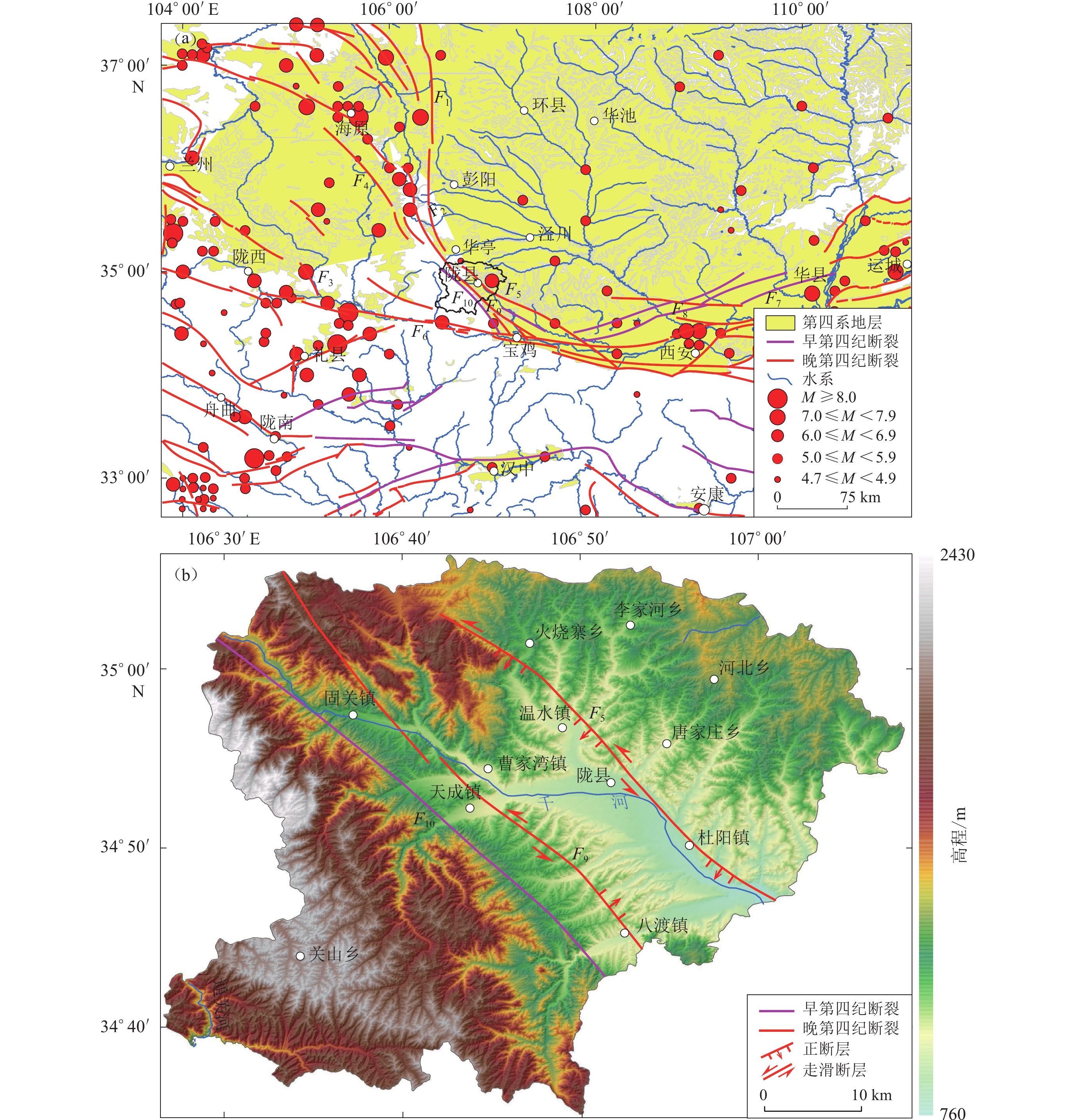
研究区位于鄂尔多斯地块西南缘(图1a),受印度板块与欧亚板块碰撞的远程效应和青藏地块向北东方向推挤的持续作用影响,区域内构造活动强烈,活动断裂发育,是历史强震多发地区,也是因灾伤亡极为惨烈的地区之一(杜兴信,张春生,1992)。区域内发育的断裂主要有固关—宝鸡断裂、岐山—马召断裂以及桃园—龟川寺断裂(图1b)(陈庆宇等,2018)。研究区及周边历史上发生过多次M>6.0地震,其中:M>8.0大地震3次,分别为 1556 年华县M8.5地震、1920海原M8.5地震和 1654 年礼县M8.0地震;M7.0—7.9地震7次;M6.0—6.9地震18次;M5.0—5.9地震47次(图1a)(袁道阳等,2004)。1556年陕西华县M8.5地震及诱发的地震滑坡造成80余万人死亡。
![]() 图 1 区域地震构造及地形地貌图(a) 研究区及周边地震和断裂分布图;(b) 陇县的数字高程模型。F1:六盘山断裂带;F2:小关山断裂; F3:通渭断裂;F4:海原断裂;F5:岐山—马召断裂;F6:西秦岭断裂;F7:双泉—临猗断裂;F8:扶风—三原—蒲城断裂;F9:固关—宝鸡断裂;F10:桃园—龟川寺断裂Figure 1. The topography and tectonic settings of the study area(a) Major active faults and large earthquakes around the study area;(b) The digital elevation model of the Longxian county. F1:Liupanshan fault zone;F2:Xiaoguanshan fault;F3: Tongwei fault;F4:Haiyuan fault;F5:Qishan-Mazhao fault;F6:West Qinling fault;F7: Shuangquan-Linyi fault;F8:Fufeng-Sanyuan-Pucheng fault;F9:Guguan-Baoji fault;F10:Taoyuan-Guichuansi fault
图 1 区域地震构造及地形地貌图(a) 研究区及周边地震和断裂分布图;(b) 陇县的数字高程模型。F1:六盘山断裂带;F2:小关山断裂; F3:通渭断裂;F4:海原断裂;F5:岐山—马召断裂;F6:西秦岭断裂;F7:双泉—临猗断裂;F8:扶风—三原—蒲城断裂;F9:固关—宝鸡断裂;F10:桃园—龟川寺断裂Figure 1. The topography and tectonic settings of the study area(a) Major active faults and large earthquakes around the study area;(b) The digital elevation model of the Longxian county. F1:Liupanshan fault zone;F2:Xiaoguanshan fault;F3: Tongwei fault;F4:Haiyuan fault;F5:Qishan-Mazhao fault;F6:West Qinling fault;F7: Shuangquan-Linyi fault;F8:Fufeng-Sanyuan-Pucheng fault;F9:Guguan-Baoji fault;F10:Taoyuan-Guichuansi fault研究区出露的地层主要有中元古界秦岭群变质岩;古生界寒武系、奥陶系海相沉积建造;中生界三叠系、侏罗系、白垩系及新生界新近系、第四系的河湖相建造和黄土;岩浆岩主要为印支期和燕山期岩浆岩,其中新近系红黏土、黄土地层以及风化残坡积物和碎屑堆积物都是易发生滑坡的地层(王师迪等,2018)。
2. 研究方法
2.1 Newmark模型的基本原理
Newmark (1965)提出了一种用于评估地震中斜坡位移和破坏的刚性滑块分析方法(图2)。在这种方法中,当地震动加速度大于临界加速度ac时,斜坡发生位移。随后,在一系列力学模型的基础上,Wilson和Keefer (1983)提出了简化Newmark模型,将水平地震动加速度简化为沿平行于滑动面下坡方向输入,分别计算斜坡在地震作用的安全系数Fs和临界加速度ac (Jibson et al,2000):
![]() 图 2 滑坡滑动体示意图(修改自 Jibson et al, 2000)Figure 2. Sliding-block model used for the Newmark analysis (revised from Jibson et al, 2000)
图 2 滑坡滑动体示意图(修改自 Jibson et al, 2000)Figure 2. Sliding-block model used for the Newmark analysis (revised from Jibson et al, 2000)$$ F_{{{\rm{s}} = }}\frac{{c'}}{{\gamma t\sin \alpha }} + \frac{{\tan \varphi '}}{{\tan \alpha }}\left(1 - m\frac{r_{\rm{w}}}{\gamma }\right) ,$$ (1) $$ a_{\rm{c}}{= ( }F_{\rm{s}}-1 ) {g} \mathrm{sin}\alpha ,$$ (2) 式中,α为滑动面倾角(近似等于滑坡的坡角),单位为°;φ′为内摩擦角,单位为°;c′为内聚力,单位为kPa;γ 为坡体的物质重度,单位为kN/m3;m 为滑坡被水浸透的厚度比,也称为斜坡的饱和度,无量纲;g 为重力加速度;t 为滑坡的厚度,单位为m,参考国内外学者的对滑体厚度的典型取值(Jibson,Keefer,1993;王涛等,2013),取滑体厚度 t=3 m; rw为地下水重度,单位为kN/m3,一般取值9.8 kN/m3。据陇县气象站多年降水量资料统计,研究区内多年平均降水量为592.5 mm,蒸发量为1 396.8 mm,约为降水量的2.35倍,因而斜坡物质含水量相对较小,这种情况下斜坡的饱和度很小,可以忽略不计,即式(1)中m=0 (马思远等,2019)。
利用临界加速度ac 计算滑坡的累积位移,还需要地震动加速度时程曲线数据(图3a);加速度值小于ac 的部分对滑块不产生位移,而加速度值大于ac的部分对时间t进行一次积分可得滑块的速度曲线(图3b);再将滑块速度对时间t进行一次积分,即可得滑块的累积位移时程曲线(图3c),表示为
![]() 图 3 Newmark模型累积位移求解原理示意图(修改自Wilson和Keefer,1983)(a) 地震动加速度时程曲线;(b) 滑动速度时程曲线;(c) 滑块累积位移时程曲线Figure 3. Illustration of Newmark double-integration (revised from Wilson and Keefer,1983)(a) Acceleration time history of seismic ground motion with the critical acceleration;(b) Velocity time history of landslide block;(c) Displacement time history of landslide block
图 3 Newmark模型累积位移求解原理示意图(修改自Wilson和Keefer,1983)(a) 地震动加速度时程曲线;(b) 滑动速度时程曲线;(c) 滑块累积位移时程曲线Figure 3. Illustration of Newmark double-integration (revised from Wilson and Keefer,1983)(a) Acceleration time history of seismic ground motion with the critical acceleration;(b) Velocity time history of landslide block;(c) Displacement time history of landslide block$$ D_{\rm{n}}{{ = }}{\iint\nolimits_t {{{[a ( t ) - a_{\rm{c}}]}}} } {\rm{d}}t \text{,} $$ (3) 式中, Dn为滑块的累积位移,a(t)为 t 时刻的地震动加速度值。
但对于本研究区而言,要对数以亿计的空间栅格逐一获取地震动加速度时程曲线,再进行严格的Newmark位移积分计算,获得潜在滑坡的危险性,在现有条件下几乎无法实现。根据相关的统计分析(Jibson,2007),Newmark位移与临界加速度 ac 和地震动峰值加速度(peak ground acceleration,缩写为PGA)存在较好的函数相关性。本文采用Jibson (2007)建立的Newmark位移 Dn与临界加速度 ac 的回归公式(标准差为 0.656):
$$ {\rm{lg}}{D_{\rm{n}}} = 0.215 + \lg{\dfrac{{\Bigg(1 - \dfrac{{{a_{\rm{c}}}}}{{{{{\rm{PGA}}}}}}\Bigg)^{2.341}} }{\Bigg(\dfrac{{{a_{\rm{c}}}}}{{{{{\rm{PGA}}}}}}{{\Bigg)}}^{1.438}}} ,$$ (4) 2.2 不确定性分析
Newmark位移模型涉及的参数包括岩体的内聚力c′、内摩擦角φ′、岩体的物质重度γ。通常这些参数被认为是确定的值,实际上它们应该服从概率分布,可以通过各种概率密度函数来建模(Mankelow,Murphy,1998;Refice,Capolongo,2002;孙军杰等,2011),然后通过蒙特卡洛方法确定斜坡的失稳概率。
本文采用β-PERT分布进行不确定性分析,因为β-PERT 分布只要求提供变量的最大值、最小值和最可能值就可以对变量的概率分布参数进行估计,而其它的分布中随机变量的取值范围往往都是开区间, 如正态分布中随机变量的取值范围是(−∞,+∞), 这就与实际情况有一些出入。另外,β-PERT分布相对比较灵活,它可能有很多种不同的形状,可以是对称的,也可以是不对称的。
蒙特卡洛模拟是利用随机抽样的方法抽取一组满足输入变量的概率分布特征的数值,而后通过大量的抽样得到相关的评价指标的概率分布和风险发生的频率值,此频率值即为风险因素的概率估计值。
2.3 研究区 ( 概率 ) 地震危险性分析
任何地震危险性分析都需要通过先了解工程场址周围地震活动水平来确定未来地震的强弱,然后结合地震所能产生的地震动强度得到工程场址的地震危险性,以概率的方式来预测未来地震活动及地震动,进而获得场点地震动参数(潘华,2002)。
地震对滑坡的影响主要是由于地震动的往复运动对边坡造成的附加力破坏了边坡的平衡条件从而导致崩滑的发生。地震危险性分析中对于地震动加速度的表达主要有地震动发生率和超越概率两种方式(Cornell,1968),而目前对于潜在地震滑坡的危险性分析一般直接使用某种超越概率水平下的地震动加速度,实际上,这两种地震动加速度的概率表达存在一定的差异(图4)。由于特定超越概率水平下的地震动只反映了部分潜在发生地震的影响,不能代表真实的地震滑坡危险性。虽然地震动超越概率和地震动发生率相差不大,尤其是在低水平超越概率下,但是严格来讲,地震动超越概率曲线并不是一个累计概率分布,而是在积分时的一个概率密度函数,所以本文采用地震动发生率进行积分,地震发生率考虑了所有潜在地震的影响。而在一般情况下,不能将这两种概率混淆。
![]() 图 4 地震发生率曲线与超越概率曲线Figure 4. Earthquake incidence curve and probability of exceedance curve
图 4 地震发生率曲线与超越概率曲线Figure 4. Earthquake incidence curve and probability of exceedance curve由于目前地震危险性分析中采用的地震活动性模型仍以泊松模型为主, 本文将以此模型为基础建立场地震动发生概率的计算公式。
根据Cornell类地震活动性模型的基本假设(Cornell,1968),建议进行如下处理。
1) 场地周围存在一系列潜在震源(假定总数为 NS)。各潜源区的震级上限为 Mmaxl,地震年平均发生率为vi,用bl表征大小地震比例关系,地震在每个潜在震源区内均匀分布,地震的震级分布为
$$ {f}_{M}^{ ( l ) } ( m ) =\left\{ \begin{array}{ll}\dfrac{{\beta }_{l}{\text{e}}^{-{\beta }_{l} ( m-{m}_{0} ) }}{1-{\text{e}}^{-{\beta }_{l} ( {M}_{\mathrm{max}l}-{m}_{0} ) }}&\quad {m}_{0}{\text{≤}} m<{M}_{\mathrm{max}l},\\ 0& \quad 其它情况,\end{array} \right. $$ (5) 式中βl =2.3bl。
2) 设潜在震源区的年平均发生率为
$$ v =\sum\limits_{l = 1}^{{N_l}} {{v_l}} \text{,} $$ (6) 则所考虑区域内发生n 次地震的概率为
$$ P ( N = n ) = \frac{{ ( vt ) ^{n}}}{{n!}}{{\text{e}}^{ - vt}}\quad n = 0, 1, 2, \cdots{\text{.}} $$ (7) 假定所考虑区域发生一次地震,可以得到场地加速度等于i 的概率为
$$ {P_I}{{ ( }}I = i{{ ) = }}\sum\limits_{l = 1}^{{N_l}} {\iint\nolimits_{x, y \in {A_l}} {\int\nolimits_{ {m_0}}^{{M_{\max l}}} {\int\nolimits_{t - 0.3}^{t + 0.7} {\frac{1}{{\sqrt {2\pi \sigma } }}} } }} {{\text{exp}}{\frac{{{{{{ [ }}t - I{{ ( }}x, y, x', y', m{{ ) ] }}}^2}}}{{2{\sigma ^2}}}}}\frac{{{v_l}}}{{v{A_l}}}f_M^{ ( l ) }{{ ( }}m{{ ) {\rm{d}}}}i{\rm{d}}m{\rm{d}}x{\rm{d}}y \text{,} $$ (8) 式中,(x,y)和($x', y' $)分别代表震中位置和场点位置,I(x,y,$x', y' $,m)为根据衰减模型计算得到加速度值(平均值),σ为地震加速度衰减关系正态分布的方差,Al 为第l 个潜在震源区的面积,vl 为第l 个潜在震源区的年平均发生率。
假定各次地震PT (I=i)具有独立分布特征,即各种地震加速度超越概率计算模型中作相同的假设,则所考虑区域发生 n 次地震,场点的地震动加速度值等于i 的概率为$ 1- [ 1- P_1 ( I=i ) ] ^n$。考虑所有可能发生的地震,则有
$$ {P_T} ( I = i ) = \sum\limits_{n = 0}^{ + \infty } {\Big\{ 1- [ 1 - {P_I} ( I = i ) } { ] }^n\Big\}\frac{{{{ ( vt ) }^n}}}{{n!}}{{\text{e}}^{ - vt}}{\text{.}} $$ (9) 根据上式可以推导出场地地震动发生概率的计算公式为
$$ {P_T}{{ ( }}I = i{{ ) = 1}} - {{\text{exp}} [ { - vt{P_I}{{ ( }}I = i{{ ) }}}} ] {\text{.}}$$ (10) 2.4 斜坡的失稳概率
根据概率危险性分析理论,一年内斜坡可能遭受的地震动强度X 是一个随机变量,其概率分布函数为
$$ F ( x ) =P ( X<x ) =1-P ( X{\text{≥}} x ) \text{,} $$ (11) 概率密度函数为
$$ f ( x ) ={\frac{ {\rm{d}}F ( x ) }{{\rm{d}}x}}\text{.} $$ (12) 已有研究表明,Newmark位移值 Dn可以看作服从标准差为 σ 的对数正态分布的随机变量(Ambraseys,Menu,1988;徐光兴等,2012;刘甲美,2016),其均值E(Dn)为斜坡临界加速度 ac和地震动峰值加速度 PGA=x的函数:
$$ E ( {D_{\rm{n}}} ) = f ( {a_{\rm{c}}}, x ) \text{.} $$ (13) 式中Dn为地震动作用下对斜坡的累积位移。当地震加速度PGA=x,临界加速度为ac的斜坡在受到地震动作用为 x时,地震滑坡概率P(slop |x)可以表达为
$$ P ( {\rm{slop}}|x ) = P ( {D_{\rm{n}}} \geqslant \lambda |x, {a_{\rm{c}}} ) \text{,} $$ (14) 式中,P(Dn≥$\lambda $|ac )表示斜坡临界加速度ac受到相应的地震动峰值加速度PGA=x时所产生的Newmark位移Dn大于λ的概率。
综合地震概率地震危险性和Newmark累积位移模型的分析结果,可以得到研究区任意场点未来一年内发生地震滑坡的概率$P ( f ) $为
$$ P ( f ) = \int {f ( x ) } P ( {\rm{slop}}|x ) {\rm{d}}x\text{,} $$ (15) 式中,f (x)为地震动强度的概率密度函数。
根据概率地震危险性分析地震活动为均匀泊松过程的假设,不同年限内场点发生地震滑坡为相互独立事件,则T年内场点发生地震滑坡的概率为
$$ P ( {\rm{slop}},T ) = 1 - {[1 - P ( {\rm{slop}} ) ]^T}{\text{.}} $$ (16) 3. 数据处理
3.1 研究区工程岩组分类及地形坡度
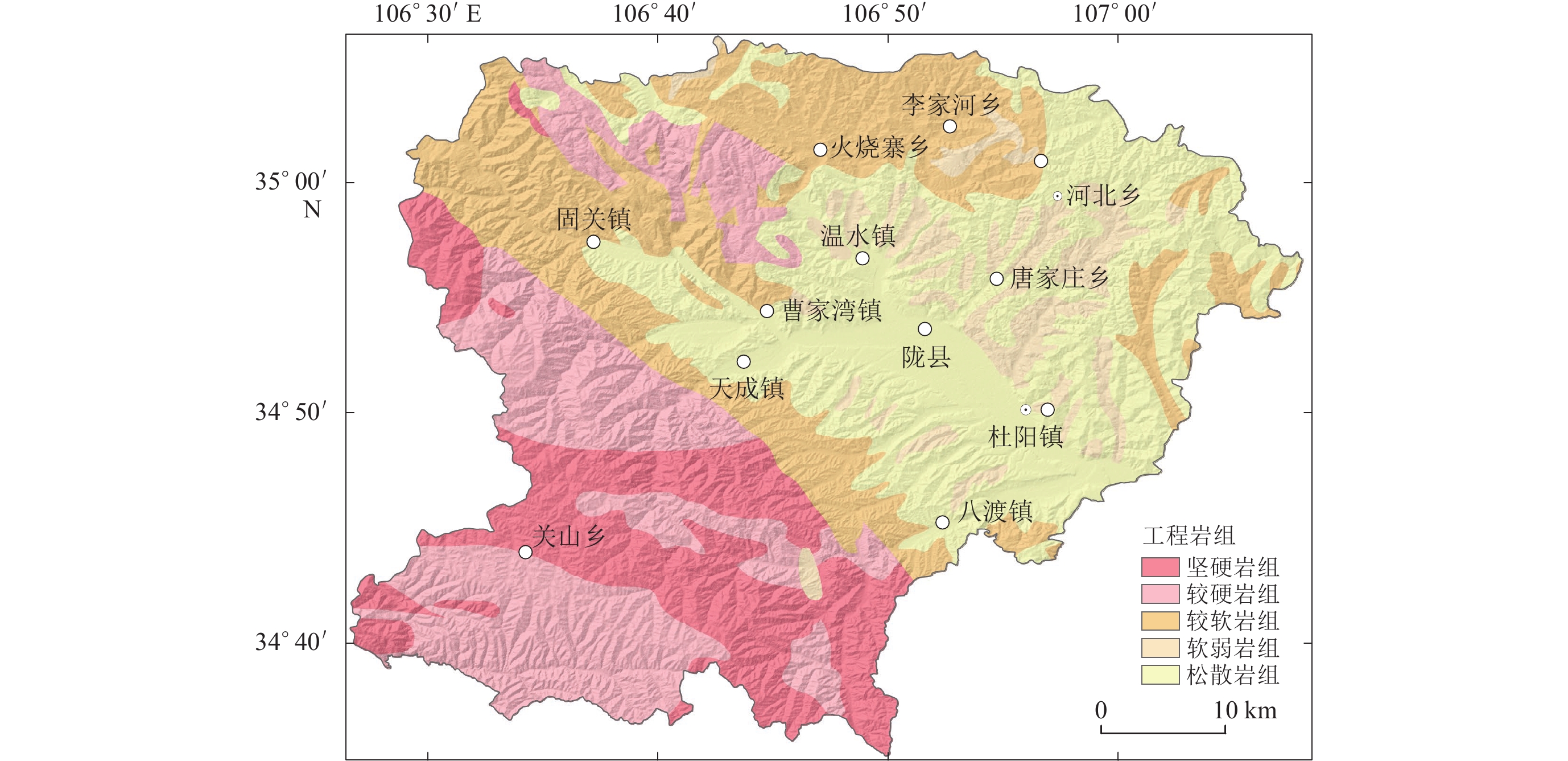
研究区地层组成较为复杂,以1 ∶ 50万区域地质图为依据,对研究区进行了工程地质岩组分类。分类依据主要参考GB 50218—1995《工程岩体分级标标准》(国家技术监督局,中华人民共和国建设部,1995)和GB 50021—2001《岩土工程勘察规范》(中华人民共和国建设部,2009)等相关规定以及前人的研究(Godt et al,2008;Dreyfus et al,2013;马思远等,2019)。根据研究区岩石完整程度、地质成因以及岩性组合等因素,结合国内外工程岩体分组经验取值,将研究区划分为坚硬岩组( Ⅰ )、较硬岩组( Ⅱ )、较软岩组( Ⅲ )、软弱岩组( Ⅳ )和松散岩组( Ⅴ )等五个岩组(图5),其中:坚硬岩组( Ⅰ )主要由志留系花岗岩以及三叠系正长岩组成;较硬岩组( Ⅱ )由侏罗系白云岩组成;较软岩组( Ⅲ )主要由白垩系灰岩以及泥质灰岩组成;软弱岩组( Ⅳ )由新近系砂岩以及红黏土组成;松散岩组( Ⅴ )主要由第四系黄土以及冲洪积物组成。
![]() 图 5 研究区工程岩组分类图(引自Jibson et al,2000)Figure 5. The rock groups based on rock strength of the study area (after Jibson et al,2000)
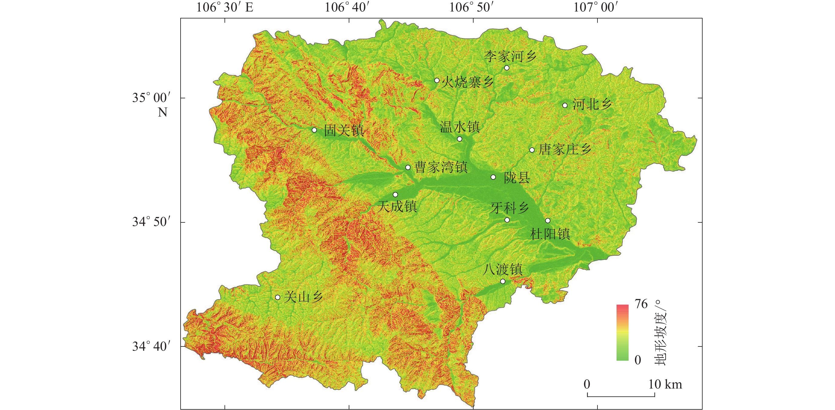
图 5 研究区工程岩组分类图(引自Jibson et al,2000)Figure 5. The rock groups based on rock strength of the study area (after Jibson et al,2000)地形坡度是影响滑坡的另一个重要因素。一般而言,地形坡度越陡,斜坡越不稳定,越容易引发滑坡。坡度是根据相邻栅格单元之间在水平方向增量和垂直方向上增量的比值而获得。陇县地区的地形坡度数据是基于ALOS DEM (advance land observing satellite digital elevation model)获取的,其空间分辨率为12.5 m×12.5 m。计算结果显示,研究区最大坡度为76°,平均坡度超过30° (图6)。
3.2 地震动峰值加速度 ( PGA )
按照 《中国地震动参数区划图宣贯教材》 (高孟潭,2015)中的技术方法和研究结果,通过选择合理的地震动峰值加速度衰减关系进行地震危险性分析计算,得到陇县地区地震发生率为50年10%水平的地震动加速度。
由于地震动受到地形的影响较大,需要进行地形校正以得到斜坡上的地震动峰值加速度。根据GB 50011—2010《建筑抗震设计规范》(中华人民共和国住房和城乡建设部,中华人民共和国国家质量监督检验检疫总局,2016)中第4.1.8条文针对局部突出地形的地震动参数放大效应的经验公式:
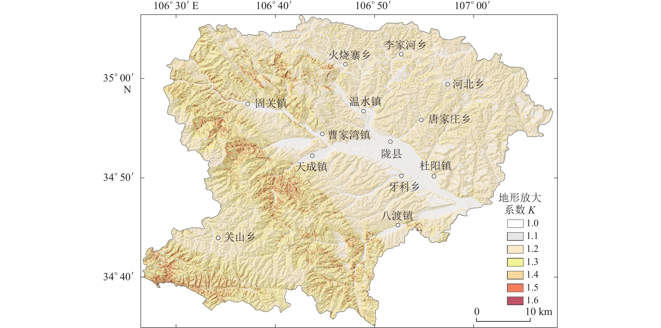
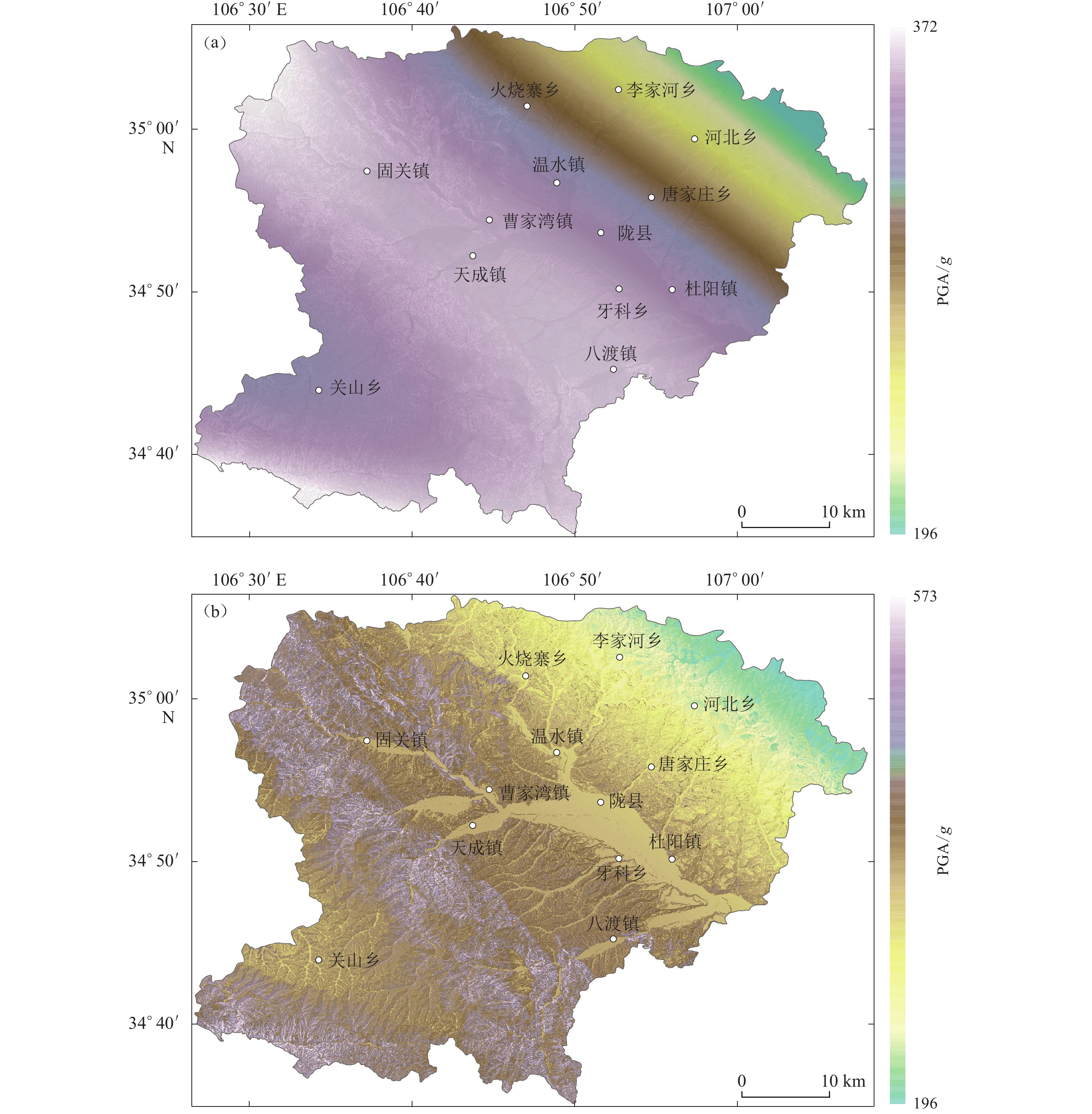
$$ K = 1 + \xi \alpha \text{,} $$ (17) 式中:K 为局部突出地形顶部的地震影响系数的放大系数;α为局部突出地形地震动参数的增大幅度,可以从坡高和坡度近似得到(表1);ξ 为附加调整系数,与斜坡离突出台地边缘的距离 L和相对高差 H 有关。为了简单起见,ξ 取值为1.0 (Wang ,Rathje,2015)。利用 DEM计算了坡高和坡度。根据公式(17)计算了陇县地区地形的地震动放大系数结果(图7),并对陇县地区地震发生率为50年10%水平的地震动加速度(图8a)进行处理,进而得到了考虑地震动放大效应后的PGA分布(图8b)。
表 1 考虑地形放大效应的经验取值Table 1. The empirical parameters considering the topographic amplification effect突出地形的高度 H/m 局部突出台地边缘的侧向平均坡降H/L 非岩质地层 岩质地层 H/L<0.3 0.3≤H/L<0.6 0.6≤H/L<1.0 H/L≥1.0 H<5 H<20 0 0.1 0.2 0.3 5≤H<15 20≤H<40 0.1 0.2 0.3 0.4 15≤H<25 40≤H<60 0.2 0.3 0.4 0.5 H≥25 H≥60 0.3 0.4 0.5 0.6 注:H/L是坡度的正切值。 ![]() 图 8 研究区50年10%超越概率水平的地震动峰值加速度(a) 未考虑地形放大效应;(b) 考虑地形放大效应Figure 8. The peak ground motion under the 10% exceedance probability of incidence rate in 50 years of study areas(a) Considering topography amplification effects;(b) Without considering topography amplification effects
图 8 研究区50年10%超越概率水平的地震动峰值加速度(a) 未考虑地形放大效应;(b) 考虑地形放大效应Figure 8. The peak ground motion under the 10% exceedance probability of incidence rate in 50 years of study areas(a) Considering topography amplification effects;(b) Without considering topography amplification effects3.3 蒙特卡洛模拟
本文选择β-PERT分布,用蒙特卡洛模拟了研究区工程岩组的内聚力c′、内摩擦角φ′以及岩体的物质重度γ随机样本值的直方图,每个样本随机抽样1万次(图9)。按照工程地质分类标准(中华人民共和国住房和城乡建设部,2015)(表2)对研究区的岩体进行分类。
![]() 图 9 工程岩组内聚力c′ (a)、内摩擦角φ′ (b)以及岩体的物质重度γ (c)的蒙特卡洛抽样结果Figure 9. Examples of the Monte Carlo simulations of effective cohesion c′ (a),effective internal friction angle φ′ (b) and density γ (c) of the rock表 2 基于Newmark模型的工程地质岩性的β-PERT分布Table 2. β-PERT distribution of the engineering geological lithology with the Newmark model
图 9 工程岩组内聚力c′ (a)、内摩擦角φ′ (b)以及岩体的物质重度γ (c)的蒙特卡洛抽样结果Figure 9. Examples of the Monte Carlo simulations of effective cohesion c′ (a),effective internal friction angle φ′ (b) and density γ (c) of the rock表 2 基于Newmark模型的工程地质岩性的β-PERT分布Table 2. β-PERT distribution of the engineering geological lithology with the Newmark model工程岩组 c′/kPa φ′/° γ /(kN·m−3) 最小值 最可能值 最大值 最小值 最可能值 最大值 最小值 最可能值 最大值 Ⅰ 30 40 60 25 40 60 23.5 27.5 32.5 Ⅱ 28 35 40 15 35 50 21.5 26.5 30.5 Ⅲ 20 28 32 12 20 30 19.5 24.5 28.5 Ⅳ 15 25 30 10 20 40 18.5 25.5 28.5 Ⅴ 8 10 15 8 10 18 15.5 21.5 25.5 注:t=3 m; γw=9.807 kN/m3 根据Newmark位移模型中的参数抽样结果,结合研究区地形坡度数据和地震动峰值加速度 PGA,利用斜坡静态安全系数Fs、临界加速度ac以及Newmark位移Dn的计算公式 [ 式(1)、式(2)和式(4) ] 获得了研究区任意斜坡单元的静态安全系数Fs、临界加速度ac以及Newmark位移 Dn的样本直方图,如图10所示。
![]() 图 10 静态安全系数Fs、临界加速度ac以及Newmark位移 Dn的蒙特卡洛抽样结果Figure 10. Examples of the Monte Carlo simulations of static safety factor Fs (a),critical acceleration ac (b) and Newmark displacement Dn (c)
图 10 静态安全系数Fs、临界加速度ac以及Newmark位移 Dn的蒙特卡洛抽样结果Figure 10. Examples of the Monte Carlo simulations of static safety factor Fs (a),critical acceleration ac (b) and Newmark displacement Dn (c)将Newmark位移Dn随机抽样N次,得到N个Newmark位移Dn随机数组。为使计算结果误差降低,N 取值应足够大(本文中N=10000)。当 N 足够大时,计算数值可看作斜坡失稳概率,此时若在 N个Newmark位移Dn中有 M 个值大于临界位移λ,则斜坡的失稳概率$P ( f ) $表示为:
$$ P ( f ) =\frac M{N}{\text{.}} $$ (18) 4. 结果
参考前人对斜坡失稳的位移临界值λ的取值(Jibson,Michael,2009;刘甲美,2016;Liu et al,2016),本文采用刘甲美(2016)在陕西华县的地震滑坡失稳临界位移取值λ=5 cm 作为斜坡失稳的临界值,那么地震峰值加速度PGA=x时,地震滑坡概率P(slop|x)可以表示为:
$$ P ( {\rm{slop}}|x ) = P ( D {\text{≥}} {\text{5 }}{\rm{cm}}|x, {a_{\rm{c}}} ) \text{,} $$ (19) 式中: P(D≥5 cm | x,ac)表示斜坡在临界加速度为ac时遭遇到相应的地震动加速度PGA=x时所产生的Newmark位移Dn大于5 cm的概率。
综合地震概率地震危险性和Newmark累积位移模型的分析结果,可以得到研究区任意场点未来一年内发生地震滑坡的概率为
$$ P ( f ) = \int {f ( x ) } P ( {\rm{slop}}|x ) {\rm{d}}x\text{,} $$ (20) 研究区内各斜坡场点在地震发生率为未来 50 年内的潜在滑坡失稳概率为
$$ P ( {\rm{slop}}, 50 ) = 1 - { [ 1 - P ( {\rm{slop}} ) ] ^{50}} {\text{.}} $$ (21) 根据概率地震危险性分析和Newmark位移模型的结果,结合式(21)对研究区内各斜坡场点进行计算,获得研究区地震滑坡的失稳概率,如图11所示。
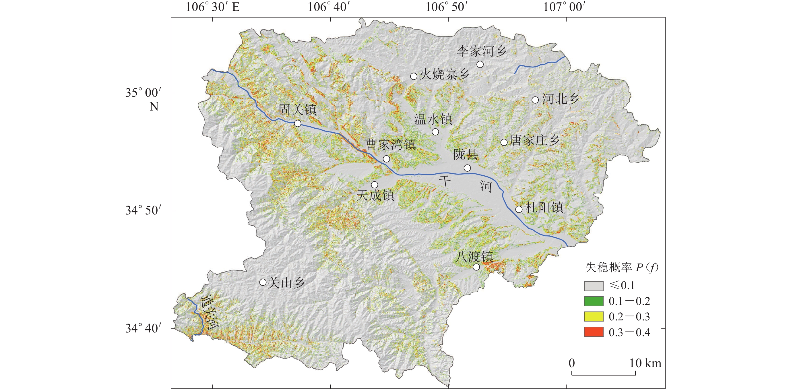
![]() 图 11 研究区地震滑坡失稳概率图Figure 11. Instability probability map of earthquake-induced landslide of the study area
图 11 研究区地震滑坡失稳概率图Figure 11. Instability probability map of earthquake-induced landslide of the study area研究区地震滑坡危险性分析结果综合了研究区地震活动性、工程地质条件等特点。根据斜坡失稳概率值的大小,同时参考前人对于滑坡危险性分级的依据(Jibson et al,2000;刘甲美等,2016),可将研究区在地震动发生率为 50年10%水平下的地震滑坡危险性划分为四个等级:极低风险(滑坡概率≤0.10)、低危险区(滑坡概率0.1—0.2)、中度危险区(0.2—0.3)和高度危险区(滑坡概率0.3—0.4),其中中、高危险区主要集中于泥岩、粉砂岩以及黄土覆盖地且斜坡坡度大于40°的地区,其中又以千河及通关河两岸部分地区的地震滑坡危险性较高。
5. 结论与讨论
地震滑坡与地震活动密切相关,不同地区地震活动的强度和频率不同。因此,基于地震危险性分析的地震滑坡危险研究是综合了地震强度、位置、复发时间等因素,考虑了地震动加速度时空分布的特点。虽然已有学者基于概率地震危险性分析做了地震滑坡的危险性分析,但大部分是基于特定超越概率水平下的地震滑坡的危险性分析,只反映了部分潜在发生的地震的影响,不能代表真实的地震滑坡危险性。本文基于概率地震危险性分析的基础上,通过蒙特卡洛模拟考虑了Newmark模型中参数的不确定性问题,给出了陇县地区地震动发生率为 50 年 10%水平下地震滑坡的危险性,充分考虑了所有潜在发生的地震的影响,为该区的工程建设以地震滑坡风险评估及管理提供参考。
本文给出了陇县地区潜在地震诱发滑坡的可能性(概率)。根据概率值的大小,可将地震滑坡危险性划分为四个等级:极低风险(滑坡概率≤0.10)、低危险区(滑坡概率0.1—0.2)、中度危险区(滑坡概率0.2—0.3)和高度危险区(滑坡概率0.3—0.4),中、高危险区主要集中于陇县地区的泥岩、粉砂岩以及黄土覆盖地且斜坡坡度大于 40° 的地区,其中又以千河及其通关河两岸部分地区的地震滑坡危险性较高。
与以往确定性的Newmark位移模型相比,本文引入蒙特卡洛模型,分析地震滑坡的危险性,并且考虑了Newmark模型中本身所涉及的岩石力学参数(φ′,c′,γ)的不确定性。与传统方法结果相比,该方法更能真实地反映滑坡的失稳概率。
国内外对地震滑坡区域的研究已从定性、半定性逐步转变为定量研究。由于地震动加速度 PGA 对地震滑坡的危险性是一个十分重要的制约因素,随着概率地震危险性分析的不断深入研究,后续的地震滑坡危险性区划结果将更加科学与实用。除此之外,地形地貌、降雨条件等因素也对滑坡的分布影响较为重要,未来的研究应该综合考虑这些因素的影响。
-
![]()
图 1 区域地震构造及地形地貌图
(a) 研究区及周边地震和断裂分布图;(b) 陇县的数字高程模型。F1:六盘山断裂带;F2:小关山断裂; F3:通渭断裂;F4:海原断裂;F5:岐山—马召断裂;F6:西秦岭断裂;F7:双泉—临猗断裂;F8:扶风—三原—蒲城断裂;F9:固关—宝鸡断裂;F10:桃园—龟川寺断裂
Figure 1. The topography and tectonic settings of the study area
(a) Major active faults and large earthquakes around the study area;(b) The digital elevation model of the Longxian county. F1:Liupanshan fault zone;F2:Xiaoguanshan fault;F3: Tongwei fault;F4:Haiyuan fault;F5:Qishan-Mazhao fault;F6:West Qinling fault;F7: Shuangquan-Linyi fault;F8:Fufeng-Sanyuan-Pucheng fault;F9:Guguan-Baoji fault;F10:Taoyuan-Guichuansi fault
![]()
图 2 滑坡滑动体示意图(修改自 Jibson et al, 2000)
Figure 2. Sliding-block model used for the Newmark analysis (revised from Jibson et al, 2000)
![]()
图 3 Newmark模型累积位移求解原理示意图(修改自Wilson和Keefer,1983)
(a) 地震动加速度时程曲线;(b) 滑动速度时程曲线;(c) 滑块累积位移时程曲线
Figure 3. Illustration of Newmark double-integration (revised from Wilson and Keefer,1983)
(a) Acceleration time history of seismic ground motion with the critical acceleration;(b) Velocity time history of landslide block;(c) Displacement time history of landslide block
![]()
图 4 地震发生率曲线与超越概率曲线
Figure 4. Earthquake incidence curve and probability of exceedance curve
![]()
图 5 研究区工程岩组分类图(引自Jibson et al,2000)
Figure 5. The rock groups based on rock strength of the study area (after Jibson et al,2000)
![]()
图 8 研究区50年10%超越概率水平的地震动峰值加速度
(a) 未考虑地形放大效应;(b) 考虑地形放大效应
Figure 8. The peak ground motion under the 10% exceedance probability of incidence rate in 50 years of study areas
(a) Considering topography amplification effects;(b) Without considering topography amplification effects
![]()
图 9 工程岩组内聚力c′ (a)、内摩擦角φ′ (b)以及岩体的物质重度γ (c)的蒙特卡洛抽样结果
Figure 9. Examples of the Monte Carlo simulations of effective cohesion c′ (a),effective internal friction angle φ′ (b) and density γ (c) of the rock
![]()
图 10 静态安全系数Fs、临界加速度ac以及Newmark位移 Dn的蒙特卡洛抽样结果
Figure 10. Examples of the Monte Carlo simulations of static safety factor Fs (a),critical acceleration ac (b) and Newmark displacement Dn (c)
![]()
图 11 研究区地震滑坡失稳概率图
Figure 11. Instability probability map of earthquake-induced landslide of the study area
表 1 考虑地形放大效应的经验取值
Table 1 The empirical parameters considering the topographic amplification effect
突出地形的高度 H/m 局部突出台地边缘的侧向平均坡降H/L 非岩质地层 岩质地层 H/L<0.3 0.3≤H/L<0.6 0.6≤H/L<1.0 H/L≥1.0 H<5 H<20 0 0.1 0.2 0.3 5≤H<15 20≤H<40 0.1 0.2 0.3 0.4 15≤H<25 40≤H<60 0.2 0.3 0.4 0.5 H≥25 H≥60 0.3 0.4 0.5 0.6 注:H/L是坡度的正切值。  下载: 导出CSV
表 2 基于Newmark模型的工程地质岩性的β-PERT分布
Table 2 β-PERT distribution of the engineering geological lithology with the Newmark model
工程岩组 c′/kPa φ′/° γ /(kN·m−3) 最小值 最可能值 最大值 最小值 最可能值 最大值 最小值 最可能值 最大值 Ⅰ 30 40 60 25 40 60 23.5 27.5 32.5 Ⅱ 28 35 40 15 35 50 21.5 26.5 30.5 Ⅲ 20 28 32 12 20 30 19.5 24.5 28.5 Ⅳ 15 25 30 10 20 40 18.5 25.5 28.5 Ⅴ 8 10 15 8 10 18 15.5 21.5 25.5 注:t=3 m; γw=9.807 kN/m3
下载: 导出CSV
-
陈庆宇,熊仁伟,田勤俭. 2018. 陇县—岐山—马召断裂几何结构特征[J]. 地震,38(3):66–80. doi: 10.3969/j.issn.1000-3274.2018.03.007 Chen Q Y,Xiong R W,Tian Q J. 2018. Segmentary characteristics of the geometrical structure of the Longxian-Qishan-Mazhao active fault[J]. Earthquake,38(3):66–80 (in Chinese).
杜兴信,张春生. 1992. 鄂尔多斯周缘地震带地震活动的分期和相关分析[J]. 地震研究,15(2):135–144. Du X X,Zhang C S. 1992. Period dividing and correlation analysis of seismicity in the seismic zones around the Erdos block[J]. Journal of Seismological Research,15(2):135–144 (in Chinese).
国家技术监督局, 中华人民共和国建设部. 1995. GB 50218—94 工程岩体分级标准[S]. 北京: 中国计划出版社: 68−69. State Bureau of Quality and Technical Supervision, Ministry of Construction of the People’s Republic of China. 1995. GB 50218−94 Standard for Engineering Classification of Rock Masses[S]. Beijing: China Planning Press: 68−69 (in Chinese).
黄润秋,李为乐. 2009. 汶川地震触发崩塌滑坡数量及其密度特征分析[J]. 地质灾害与环境保护,20(3):1–7. doi: 10.3969/j.issn.1006-4362.2009.03.001 Huang R Q,Li W L. 2009. Analysis on the number and density of landslides triggered by the 2008 Wenchuan earthquake,China[J]. Journal of Geological Hazards and Environment Preservation,20(3):1–7 (in Chinese).
高孟潭. 2015. GB 18306—2015《中国地震动参数区划图》宣贯教材[M]. 北京: 中国质检出版社: 138−142. Gao M T. 2015. Teaching Book for GB18306−2015 Seismic Ground Motion Parameters Zonation Map of China[M]. Beijing: China Quality Inspection Press: 138−142 (in Chinese).
李雪婧,高孟潭,徐伟进. 2019. 基于Newmark模型的概率地震滑坡危险性分析方法研究:以甘肃天水地区为例[J]. 地震学报,41(6):795–807. doi: 10.11939/jass.20180075 Li X J,Gao M T,Xu W J. 2019. Probabilistic seismic slope displacement hazard analysis based on Newmark displacement model:Take the area of Tianshui,Gansu Province,China as an example[J]. Acta Seismologica Sinica,41(6):795–807 (in Chinese).
刘甲美. 2016. 概率地震滑坡危险性区划方法及应用[J]. 国际地震动态,(1):45–46. Liu J M. 2016. The method and application of probabilistic seismic hazard assessment for sliding displacement of slopes[J]. Recent Developments in World Seismology,(1):45–46 (in Chinese).
刘甲美,高孟潭,吴树仁. 2016. 概率性地震滑坡危险性区划方法及其应用[J]. 岩石力学与工程学报,35(增刊1):3100–3110. doi: 10.13722/j.cnki.jrme.2015.0118 Liu J M,Gao M T,Wu S R. 2016. Probabilistic seismic landslide hazard zonation method and its application[J]. Chinese Journal of Rock Mechanics and Engineering,35(S1):3100–3110 (in Chinese).
马思远,许冲,王涛,刘甲美. 2019. 应用2类Newmark简易模型进行2008年汶川地震滑坡评估[J]. 地震地质,41(3):774–788. doi: 10.3969/j.issn.0253-4967.2019.03.015 Ma S Y,Xu C,Wang T,Liu J M. 2019. Application of two simplified Newmark models to the assessment of landslides triggered by the 2008 Wenchuan earthquake[J]. Seismology and Geology,41(3):774–788 (in Chinese).
潘华. 2002. 概率地震危险性分析中参数不确定性研究[J]. 国际地震动态,(2):16–17. doi: 10.3969/j.issn.0253-4975.2002.02.010 Pan H. 2002. Study on uncertainty in parameters of probability seismic hazard analysis[J]. Recent Developments in World Seismology,(2):16–17 (in Chinese).
孙军杰,王兰民,龙鹏伟,陈光齐. 2011. 地震与降雨耦合作用下区域滑坡灾害评价方法[J]. 岩石力学与工程学报,30(4):752–760. Sun J J,Wang L M,Long P W,Chen G Q. 2011. An assessment method for regional susceptibility of landslides under coupling condition of earthquake and rainfall[J]. Chinese Journal of Rock Mechanics and Engineering,30(4):752–760 (in Chinese).
王师迪,师亚芹,董云鹏. 2018. 青藏高原东北缘固关—虢镇断裂中段第四纪以来活动特征[J]. 地质科学,53(3):781–798. doi: 10.12017/dzkx.2018.044 Wang S D,Shi Y Q,Dong Y P. 2018. The active characteristics in the Quaternary period of the middle Guguan-Guozhen fault,northeast margin of Qinghai-Tibet Plateau[J]. Chinese Journal of Geology,53(3):781–798 (in Chinese).
王涛,吴树仁,石菊松,辛鹏. 2013. 基于简化Newmark位移模型的区域地震滑坡危险性快速评估:以汶川MS8.0级地震为例[J]. 工程地质学报,21(1):16–24. doi: 10.3969/j.issn.1004-9665.2013.01.003 Wang T,Wu S R,Shi J S,Xin P. 2013. Case study on rapid assessment of regional seismic landslide hazard based on simplified Newmark displacement model:Wenchuan MS8.0 earthquake[J]. Journal of Engineering Geology,21(1):16–24 (in Chinese).
许冲,戴福初,徐锡伟. 2010. 汶川地震滑坡灾害研究综述[J]. 地质论评,56(6):860–874. doi: 10.16509/j.georeview.2010.06.017 Xu C,Dai F C,Xu X W. 2010. Wenchuan earthquake-induced landslides:An overview[J]. Geological Review,56(6):860–874 (in Chinese).
徐光兴,姚令侃,李朝红,王晓放. 2012. 基于汶川地震强震动记录的边坡永久位移预测模型[J]. 岩土工程学报,34(6):1131–1136. Xu G X,Yao L K,Li C H,Wang X F. 2012. Predictive models for permanent displacement of slopes based on recorded strong-motion data of Wenchuan earthquake[J]. Chinese Journal of Geotechnical Engineering,34(6):1131–1136 (in Chinese).
袁道阳,雷中生,刘小凤,刘百篪,才树华,郑文俊. 2004. 138年金城—陇西63/4级地震的史料考证与发震构造背景探讨[J]. 地震地质,26(1):52–60. Yuan D Y,Lei Z S,Liu X F,Liu B C,Cai S H,Zheng W J. 2004. Textual research on the historical data of the 138 AD Jincheng−Longxi M63/4 earthquake and discussion on its seismogenic structural background[J]. Seismology and Geology,26(1):52–60 (in Chinese).
中华人民共和国住房和城乡建设部. 2015. GB/T 50218—2014 工程岩体分级标准[S]. 北京: 中国计划出版社: 12. Ministry of Housing and Urban-Rural Development of the People’s Republic of China. 2015. GB/T 50218−2014 Standard for Engineering Classification of Rock Masses[S]. Beijing: China Planning Press: 12 (in Chinese).
中华人民共和国建设部. 2009. GB 50021—2001 岩土工程勘察规范(2009年版)[S]. 北京: 中国建筑工业出版社: 136−140. Ministry of Construction of the People’s Republic of China. 2009. GB 50021−2001 Code for Investigation of Geotechnical Engi-neering (2009 Edition)[S]. Beijing: China Architecture & Building Press: 136−140 (in Chinese).
中华人民共和国住房和城乡建设部, 中华人民共和国国家质量监督检验检疫总局. 2016. GB 50011—2010 建筑抗震设计规范[S]. 北京: 中国建筑工业出版社: 19–21. Ministry of Housing and Urban-Rural Development of the People’s Republic of China, General Administration of Quality Supervision, Inspection and Quarantine of the People’s Republic of China. 2010. GB 50011—2010 Code for Seismic Design of Buildings[S]. Beijing: China Architecture & Building Press: 19–21 (in Chinese).
Ambraseys N N,Menu J M. 1988. Earthquake-induced ground displacements[J]. Earthq Eng Struct Dyn,16(7):985–1006.
Cornell C A. 1968. Engineering seismic risk analysis[J]. Bull Seismol Soc Am,58(5):1583–1606. doi: 10.1785/BSSA0580051583
Dreyfus D,Rathje E M,Jibson R W. 2013. The influence of different simplified sliding-block models and input parameters on regional predictions of seismic landslides triggered by the Northridge earthquake[J]. Eng Geol,163:41–54. doi: 10.1016/j.enggeo.2013.05.015
Gallen S F,Clark M K,Godt J W,Roback K,Niemi N A. 2017. Application and evaluation of a rapid response earthquake-triggered landslide model to the 25 April 2015 MW7.8 Gorkha earthquake,Nepal[J]. Tectonophysics,714/715:173–187. doi: 10.1016/j.tecto.2016.10.031
Godt J W, Sener B, Verdin K L, Wald D, Earle P. 2008. Rapid assessment of earthquake-induced landsliding[C]//Global Promotion Committee of the International Programme on Landslides (IPL). Tokyo: United Nations University: 463−468.
Jibson R W,Keefer D K. 1993. Analysis of the seismic origin of landslides:Examples from the New Madrid seismic zone[J]. Geol Soc Am Bull,105(4):521–536.
Jibson R W. 2007. Regression models for estimating coseismic landslide displacement[J]. Eng Geol,91(2/3/4):209–218.
Jibson R W,Harp E L,Michael J A. 2000. A method for producing digital probabilistic seismic landslide hazard maps[J]. Eng Geol,58(3/4):271–289.
Jibson R W, Michael J A. 2009. Maps Showing Seismic Landslide Hazards in Anchorage, Alaska[R]. Reston: Center for Integrated Data Analytics Wisconsin Science Center: 1−9.
Keefer D K. 1984. Landslides caused by earthquakes[J]. Geol Soc Am Bull,95(4):406–421. doi: 10.1130/0016-7606(1984)95<406:LCBE>2.0.CO;2
Liu J M,Gao M T,Wu S R,Wang T,Wu J. 2016. A hazard assessment method for potential earthquake induced landslides:A case study in huaxian county,shaanxi province[J]. Acta Geologica Sinica,90(2):14.
Mankelow J M,Murphy W. 1998. Using GIS in the probabilistic assessment of earthquake triggered landslide hazards[J]. J Earthq Eng,2(4):593–623.
Newmark N M. 1965. Effects of earthquakes on dams and embankments[J]. Géotechnique,15(2):139–160.
Rathje E M, Saygili G. 2008. Probabilistic seismic hazard analysis for the sliding displacement of slopes:Scalar and vector approaches[J]. J Geotech Geoenviron Eng,134(6):804–814.
Rathje E M, Saygili G. 2009. Probabilistic assessment of earthquake-induced sliding displacements of natural slopes[J]. Bull N Z Soc Earthq,42(1):18–27.
Refice A,Capolongo D. 2002. Probabilistic modeling of uncertainties in earthquake-induced landslide hazard assessment[J]. Comput Geosci,28(6):735–749. doi: 10.1016/S0098-3004(01)00104-2
Urzúa A,Christian J T. 2013. Sliding displacements due to subduction-zone earthquakes[J]. Eng Geol,166:237–244. doi: 10.1016/j.enggeo.2013.08.005
Wang Y B,Rathje E M. 2015. Probabilistic seismic landslide hazard maps including epistemic uncertainty[J]. Eng Geol,196:313–324. doi: 10.1016/j.enggeo.2015.08.001
Wilson R C,Keefer D K. 1983. Dynamic analysis of a slope failure from the 6 August 1979 Coyote lake,California,earthquake[J]. Bull Seismol Soc Am,73(3):863–877. doi: 10.1785/BSSA0730030863
Xu C,Xu X W,Dai F C,Saraf A K. 2012. Comparison of different models for susceptibility mapping of earthquake triggered landslides related with the 2008 Wenchuan earthquake in China[J]. Comput Geosci,46:317–329. doi: 10.1016/j.cageo.2012.01.002
Xu Y R,Allen M B,Zhang W H,Li W Q,He H L. 2020. Landslide characteristics in the Loess Plateau,northern China[J]. Geomorphology,359:107150. doi: 10.1016/j.geomorph.2020.107150
-
期刊类型引用(1)
1. 任正情,刘传奇,陈成名,朱丽,陈涛. 基于信息量和Newmark模型的地震地质灾害危险性评价——以安徽省六安市霍山县落儿岭地区为例. 安徽地质. 2023(04): 292-297 .  百度学术
百度学术
其他类型引用(2)


计量
- 文章访问数: 472
- HTML全文浏览量: 226
- PDF下载量: 171
- 被引次数: 3
