

Risk-targeted seismic zoning maps
-
摘要: 为保证国土范围内建筑倒塌风险的一致性,提出了基于目标风险的地震区划图。该图通过求取地震危险性曲线与结构易损性曲线的卷积的风险积分方法计算目标风险。本文介绍了采用风险积分法确定基于目标风险的地震动参数的基本原理,回顾了这项技术在国内外研究与应用的最新进展。此外,还讨论了基于目标风险的地震区划图未来的发展及可能面临的问题。Abstract: To ensure the consistency of building collapse risk within the country, a risk-targeted seismic zoning map is proposed. The risk integral method calculates the target risk by the convolution of the seismic hazard curve and the structural vulnerability curve. Currently, the use of risk-targeted seismic zoning maps has been widely used in practice in the United States, and related studies have been conducted in France, Romania, Canada, Indonesia, Europe and China. This article introduces the basic principles of using the risk integral method to determine the risk-targeted ground motion parameters and reviews the recent progress of research and application of this technique in China and abroad. In addition, we discuss the future development of risk-targeted seismic zoning maps and some of the problems may face.
-
Keywords:
- risk integral /
- risk-targeted /
- acceptable risk /
- seismic zoning map /
- seismic design map
-
-
![]()
![]()
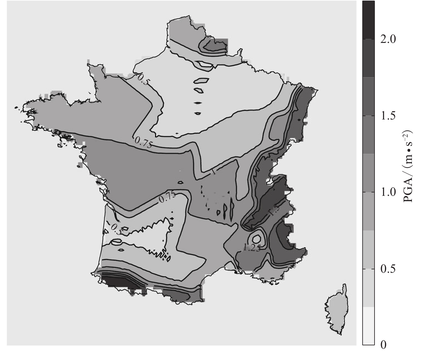
图 2 法国大陆基于目标风险的PGA抗震设计图(引自Douglas et al,2013)
Figure 2. Seismic design map of risk-targeted PGA in France (after Douglas et al,2013)
![]()
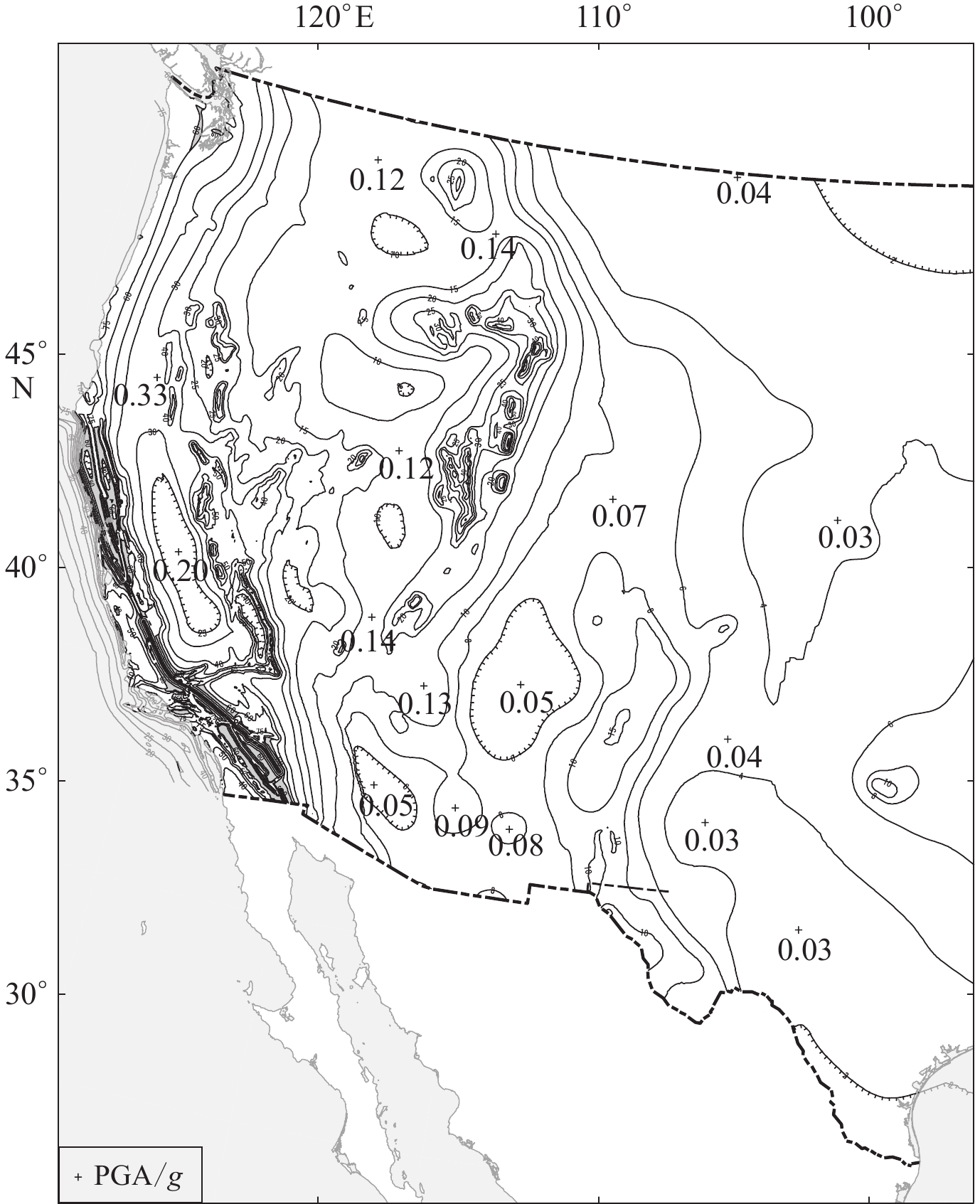
图 3 欧洲大陆基于目标风险的PGA风险系数图(引自Silva et al,2016)
Figure 3. Risk coefficients map of risk-targeted PGA in Europe (after Silva et al,2016)
-
潘华,张萌,李金臣. 2017. 美国地震区划图的发展:地震危险性图与抗震设计图[J]. 震灾防御技术,12(3):511–522. Pan H,Zhang M,Li J C. 2017. Review of seismic zonation in United States,seismic hazard maps and seismic design maps[J]. Technology for Earthquake Disaster Prevention,12(3):511–522 (in Chinese).
王丛,吕大刚. 2020. 基于抗震规范和地震动区划图的风险导向地震动决策参数分析[J]. 建筑结构学报,41(8):19–28. doi: 10.14006/j.jzjgxb.2018.0703 Wang C,Lü D G. 2020. Analysis of risk-targeted decision parameters of seismic ground motions based on seismic design code and ground motion zonation map of China[J]. Journal of Building Structures,41(8):19–28 (in Chinese).
张萌. 2021. 基于风险的地震动确定[D]. 北京: 中国地震局地球物理研究所: 45–48. Zhang M. 2021. Risk-Targeted Ground Motion and Its Application[D]. Beijing: Institute of Geophysics, China Earthquake Administration: 45–48 (in Chinese).
张萌, 潘华. 2022. 中国大陆地区建筑结构一致倒塌风险的设计地震动研究[J/OL]. 建筑结构学报. doi: 10.14006/j.jzjgxb.2021.0317. Zhang M, Pan H. 2022. Study on design ground motion for uniform collapse risk of building structures in mainland China[J/OL]. Journal of Building Structures. doi: 10.14006/j.jzjgxb.2021.0317 (in Chinese).
张萌,潘华,李金臣. 2017. 美国建筑抗震设计的法规体系与设计地震动的确定[J]. 震灾防御技术,12(2):306–318. doi: 10.11899/zzfy20170207 Zhang M,Pan H,Li J C. 2017. Building anti-seismic design regulations in the United States and its approach to ground motion design[J]. Technology for Earthquake Disaster Prevention,12(2):306–318 (in Chinese).
中华人民共和国国家质量监督检验检疫总局, 中国国家标准化管理委员会. 2016. GB 18306—2015中国地震动参数区划图[S]. 北京: 中国标准出版社: 4. General Administration of Quality Supervision, Inspection and Quarantine of the People’s Republic of China, Standardization Administration of the People’s Republic of China. 2016. GB 18306−2015 Seismic Ground Motion Parameters Zonation Map of China[S]. Beijing: Standards Press of China: 4 (in Chinese).
中华人民共和国住房和城乡建设部, 中华人民共和国国家质量监督检验检疫总局. 2010. GB 50011—2010建筑抗震设计规范[S]. 北京: 中国建筑工业出版社: 18−20. Ministry of Housing and Urban-Rural Development of the People’s Republic of China, General Administration of Quality Supervision, Inspection and Quarantine of the People’s Republic of China. 2010. GB 50011−2010 Code for Seismic Design of Buildings[S]. Beijing: China Architecture & Building Press: 18−20 (in Chinese).
Allen T I, Adams J, Halchuk S. 2015. The seismic hazard model for Canada: Past, present and future[C]//Proceedings of the Tenth Pacific Conference on Earthquake Engineering Building: An Earthquake-Resilient Pacific. Sydney, Australia: Seismology Research Center: 5.
ASCE. 2005. ASCE/SEI 43-05 Seismic Design Criteria for Structures, Systems, and Components In Nuclear Facilities[S]. Reston, Virginia: ASCE: 109−117.
ASCE. 2010. ASCE 7-10 Minimum Design Loads for Buildings and Other Structures[S]. Reston, Virginia: American Society of Civil Engineers: 207−211.
ATC. 1978. Tentative Provisions for the Development of Seismic Regulations for Buildings, Report ATC 3-06[R]. Washington D C: Applied Technology Council, National Bureau of Standards, U.S. Government Printing Office: 296−312.
Douglas J,Ulrich T,Negulescu C. 2013. Risk-targeted seismic design maps for mainland France[J]. Nat Hazards,65(3):1999–2013. doi: 10.1007/s11069-012-0460-6
Federal Emergency Management Agency, 1998. NEHRP Recommended Provisions for Seismic Regulations for New Buildings and Other Structures, Part 1: Provisions[R]. Washington D C: Federal Emergency Management Agency, Building Seismic Safety Council: 10−18.
Federal Emergency Management Agency. 2009. NEHRP Recommended Seismic Provisions for New Buildings and Other Structures: FEMAP-750[R]. Washington D C: Federal Emergency Management Agency: 21−28.
Federal Emergency Management Agency. 2010. Earthquake-Resistant Design Concepts: An Introduction to the NEHRP Recommended Seismic Provisions for New Buildings and Other Structures: FEMAP-749[R]. Washington D C: Federal Emergency Management Agency: 13−20.
Iervolino I, Spillatura A, Bazzurro P. 2017. RINTC project: Assessing the (implicit) seismic risk of code-conforming structures in Italy[C]//6th ECCOMAS Thematic Conference on Computational Methods in Structural Dynamics and Earthquake Engineering. Rhodes, Greece: Institute of Structural Analysis and Antiseismic Research, School of Civil Engineering, National Technical University of Athens (NTUA), Greece: 1545–1557.
Kennedy R P, Short S A. 1994. Basis for Seismic Provisions of DOE-STD-1020[R]. Washington D C: USDOE: 1–4.
Kennedy R P. 2011. Performance-goal based (risk informed) approach for establishing the SSE site specific response spectrum for future nuclear power plants[J]. Nucl Eng Des,241(3):648–656. doi: 10.1016/j.nucengdes.2010.08.001
Kharazian A,Molina S,Galiana-Merino J J,Agea-Medina N. 2021. Risk-targeted hazard maps for Spain[J]. Bull Earthq Eng,19(13):5369–5389. doi: 10.1007/s10518-021-01189-8
Liel A B, Luco N, Raghunandan M, Champion C P. 2015. Modifications to risk-targeted seismic design maps for subduction and near-fault hazards[C]//12th International Conference on Applications of Statistics and Probability in Civil Engineering. Vancouver, Canada: Civil Engineering Risk and Reliability Association: 1–8.
Luco N, Ellingwood B R, Hamburger R O, Hooper J D, Kimball J K, Kircher C A. 2007. Risk-targeted versus current seismic design maps for the conterminous United States[C]//SEAOC 2007 Convention Proceedings. California: Structural Engineers Association of California: 1–7.
McGuire R K. 2004. Seismic Hazard and Risk Analysis[M]. Oakland, CA: Earthquake Engineering Research Institute: 143–153.
Sengara I W,Sidi I D,Mulia A,Asrurifak M,Hutabarat D. 2016. Development of risk coefficient for input to new Indonesian seismic building codes[J]. J Eng Technol Sci,48(1):49–65. doi: 10.5614/j.eng.technol.sci.2016.48.1.5
Sengara I W, Irsyam M, Sidi I D, Mulia A, Asrurifak M, Hutabarat D, Partono W. 2020. New 2019 risk-targeted ground motions for spectral design criteria in Indonesian seismic building code[C/OL]. E3S Web Conf, 156(1): 03010.
Silva V,Crowley H,Bazzurro P. 2016. Exploring risk-targeted hazard maps for Europe[J]. Earthq Spectra,32(2):1165–1186. doi: 10.1193/112514eqs198m
Taherian A R,Kalantari A. 2019. Risk-targeted seismic design maps for Iran[J]. J Seismol,23:1299.
Taherian A R,Kalantari A. 2021. Analysis of the risk-targeting approach to defining ground motion for seismic design:A case study of Iran[J]. Bull Earthq Eng,19(3):1289–1309. doi: 10.1007/s10518-020-01023-7
USNRC. 2007. A Performance-Based Approach to Define the Site-Specific Earthquake Ground Motion[S]. Washington D C: USNRC: 17–18.
Vacareanu R,Pavel F,Craciun I,Coliba V,Arion C,Aldea A,Neagu C. 2018. Risk-targeted maps for Romania[J]. J Seismol,22(2):407–417. doi: 10.1007/s10950-017-9713-x
 下载:
下载:

计量
- 文章访问数: 507
- HTML全文浏览量: 290
- PDF下载量: 177
