

3D High-resolution S-wave velocity structure of the lithosphere beneath North China Craton based on Eikonal surface wave tomography
-
摘要:
利用“中国地震科学台阵探测”项目Ⅱ期和Ⅲ期的流动地震台站以及中国区域地震台网中的部分固定台站的观测资料,采用程函面波成像方法获得了华北克拉通及周边区域10—120 s周期的瑞雷面波相速度分布和高分辨率的三维S波速度结构,并基于该速度模型估算了岩石圈厚度分布。结果显示,华北克拉通内部岩石圈厚度除了存在“西厚东薄”的一级分布特征外,还存在一些更小尺度的差异,包括鄂尔多斯地块内部岩石圈“南厚北薄”、鄂尔多斯地块周缘断陷带岩石圈显著的不均匀减薄以及燕山构造带与其南侧华北平原之间的显著差异等。山西断陷带北部与南部地区上地幔浅部(<100 km)存在不同程度的低速异常,它们被中部的高速异常区所分隔。在150 km以下深度从太行山南缘向北至山西断陷北缘存在一条NNE向展布的显著低速异常带,表明上地幔浅部南北部的低速异常在深部相连。结合已有的其它成像结果,我们推测这些低速异常起源于更深处(>200 km),并与由太平洋俯冲板块的滞留脱水导致的上地幔热物质上涌和小尺度地幔对流等密切相关。燕山构造带与华北平原的岩石圈结构存在明显差异,前者遭受的岩石圈破坏改造程度明显弱于后者,张家口—渤海地震带位于这两种不同壳幔结构的过渡带,地震活动较强,我们认为深部结构和热作用的显著差异,以及青藏高原远场挤压效应的共同作用是导致该区地震活动较强的主要原因。
Abstract:The North China Craton has undergone intensely tectonic reactivation since the Mesozoic, which resulted in lithosphere modification, thinning and destruction, and accompanied by large amount of magmatic activity. The neotectonic movement is strong and destructive earthquakes occur frequently in this region. It is of great significance to obtain medium deformation and structure information in the crust and upper mantle for understanding these process. High-resolution lithosphere structure will provide important basis for understanding a series of scientific issues such as the tectonic deformation of crust-mantle media, the interaction between structural blocks, the deep environment of strong earthquakes, the spatial distribution range and dynamic mechanism of lithosphere thinning and destruction.
Many researches about seismic tomography have been carried out in the North China Craton. But, the results of high-resolution of the lithosphere across the whole North China Craton are still few, due to the limitation of observation conditions or range, which limits further analysis on a series of scientific issues. As the rapid development of seismic array observation technology, some high-resolution seismic tomography techniques appear which suitable for dense arrays. The Eikonal surface wave tomography takes into account the bending phenomenon of seismic wave propagation path in complex media, and is suitable for both ambient noise and seismic surface wave. Its lateral resolution is equivalent to the average spacing of stations for arrays with relatively uniform distribution of stations. Considering that the ambient noise tomography is limited to medium and short periods (generally below 40 s), which mainly restricts the depth range from the crust to the top of the upper mantle so that it is difficult to carry out research and discussion on deeper depths. In this study, we choose the surface wave observation data to extract Rayleigh wave phase velocity of medium and long period by Eikonal surface wave tomograph, which can provide constraints on the entire lithosphere depth range.
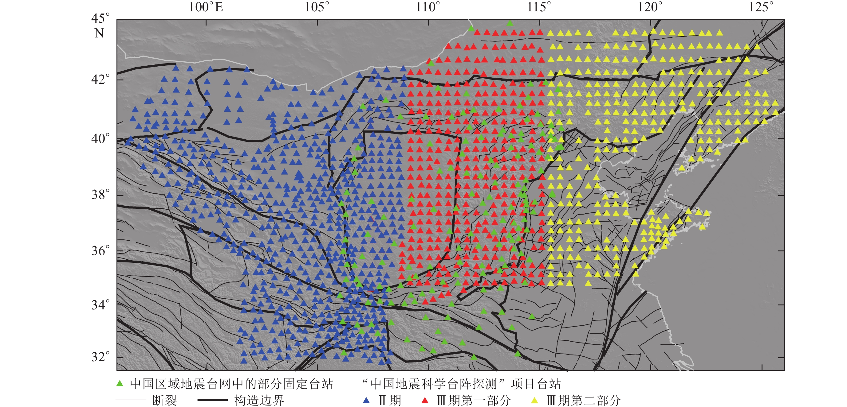
We collected the surface wave data of teleseismic events from
1513 seismic stations in this study, including 670 portable stations from ChinArray PhaseⅡ, 361 portable stations from ChinArray Phase Ⅲ−1 , 324 portable stations from ChinArray Phase Ⅲ−2 , and 158 permanent stations from China National Seismic Network (CSN). This is the most intensive seismic station bservations in the study region, with an average station spacing of about 35 km. Their corresponding observation periods are September 2013 to June 2016, November 2016 to January 2019, November 2017 to November 2020, and April 2016 to January 2019. The 3D high-resolution S-wave velocity model was obtained by two-step method in the depth range of 200 km below the study region. Firstly, We obtained the phase velocity of Rayleigh surface wave at 10−120 s by Eikonal surface wave tomography and extracted the pure path dispersion curves of each grid node on the surface. Secondly, we obtained these one-dimensional S-wave velocity models at these corresponding nodes by linear inversion method, then all the one-dimensional S-wave velocity models are combined to obtain the 3D S-wave velocity model. The lithosphere thickness is estimated by the empirical relationship between upper mantle S-wave velocity and pressure and temperature based on this model.The results showed that there are some smaller scale variations of the lithosphere thickness in the North China Craton in addition to the first-order distribution characteristics of ‘thick in the west and thin in the east’. Which includes: ① within the Ordos block, the lithosphere is thinner in the north than that in the south; ② within the peripheral rift zone around Ordos block, it is characterized by significantly heterogeneous thinned lithosphere; ③ there is significant difference between Yanshan Orogenic Belt and North China plain on its south side.In Shanxi rift zone, both the northern and southern regions exhibit varying degrees of low velocity anomalies in the upper mantle (<100 km), which are separated by a high velocity anomaly zone in the central area.At depth of more than 150 km, a remarkable low-velocity anomaly belt oriented NNE is observed from the southern edge of Taihang Mountain to the northern edge of Shanxi rift zone, indicating that the shallow upper mantle low-velocity anomalies are connected in the deep.Combined with some other research findings, we speculated that these low-velocity anomalies may stem from a greater depth (>200 km), potentially linked with the stagnant dehydration of the subducted Pacific plate and consequent upwelling of thermal material in the upper mantle, as well as small-scale mantle convection. The lithospheric structures of the Yanshan Orogenic belt is significantly different from North China Plain, with former experienced much less destruction and reconstruction. Zhangjiakou−Bohai seismic zone is located at the transitional region between these two distinct crust-mantle structures, and characterized by intense seismic activity. We concluded that the combination of significant differences in deep structure and thermal action, as well as the far-field extrusion effect of the Qinghai−XizangPlateau, mainly contributes to the intense seismic activity in this zone. There are some significant high velocity anomalies near the depth of 200 km in Yanshan Orogenic Belt, northern part of the North China Plain and around Bohai Bay. It is speculated that these anomalies may be related to the local delamination of the lithosphere, which represent the remnants of the Archean cratonic lithosphere sinking into the asthenosphere.
-
-
![]()
图 8 不同深度的S波速度分布(图中v0代表每个深度h对应的平均速度)
Figure 8. S-wave velocity maps at different depths (v0 represents the average S-wave velocity corresponding to each depth h)
(a) h=10 km;(b) h=20 km;(c) h=40 km;(d) h=50 km;(e) h=60 km;(f) h=80 km; (g) h=100 km;(h) h=150 km;(i) h=200 km
![]()
图 1 研究区构造背景分布图
图中地震为1970年以来记录到的5级以上地震(国家地震局震害防御司,1995;中国地震局震害防御司,1999)。左上角图中图显示了华北克拉通及其周边区域更大范围的构造背景。其中蓝色矩形代表放大区域范围;红色实线代表板块边界(Bird,2003);黑色空心箭头示意板块运动方向(Kreemer et al,2014)
Figure 1. Tectonic setting of the studied area
The represented earthquakes are MS≥5.0 recorded since 1970 (Department of Earthquake Disaster Prevention,State Seismological Bureau,1995;Department of Earthquake Disaster Prevention,China Earthquake Administration,1999). The upper left image shows the larger tectonic background of the North China Craton and its surrounding region;The blue rectangle represents the location of this study area;the solid red lines represent plate boundaries (Bird,2003); the black hollow arrows indicate the motion direction of the plates (Kreemer et al,2014)
![]()
图 4 不同周期的基阶瑞雷面波相速度对S波速度的敏感曲线
Figure 4. Sensitivity kernel curves of fundamental Rayleigh wave phase velocity to shear wave velocity at different periods
(a) 10—40 s;(b) 40—120 s
![]()
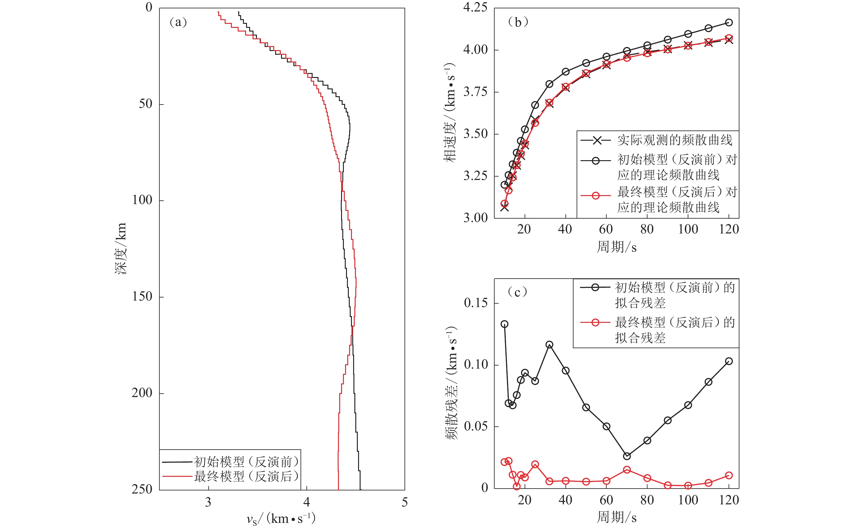
图 5 面波频散曲线反演一维S波速度结构示例(35.00°N,112.25°E)
(a) 反演前后的一维S波速度模型;(b) 反演前后频散曲线的拟合情况;(c) 反演前后的频散残差分布
Figure 5. Example of inversion of surface wave dispersion data for S-wave velocity (35.00°N,112.25°E)
(a) The 1-D S-wave velocity models pre- and post-inversion;(b) The fitting distribution of dispersion curves pre- and post-inversion;(c) The dispersion residual distribution pre- and post-inversion
![]()
图 6 相速度误差分布
Figure 6. Error distribution of the phase velocity
(a) T=10 s;(b) T=14 s;(c) T=20 s;(d) T=25 s;(e) T=32 s;(f) T=40 s;(g) T=50 s; (h) T=60 s;(i) T=70 s;(j) T=80 s;(k) T=100 s;(l) T=120 s
![]()
图 7 瑞雷面波相速度分布图像(图中v0代表每个周期T对应的平均相速度)
Figure 7. Rayleigh wave phase velocity maps at different periods (v0 represents the average phase velocity corresponding to each period T)
(a) T=10 s;(b) T=14 s;(c) T=20 s;(d) T=25 s;(e) T=32 s;(f) T=40 s;(g) T=50 s; (h) T=60 s;(i) T=70 s;(j) T=80 s;(k) T=100 s;(l) T=120 s
![]()
图 9 华北克拉通及其周边区域岩石圈厚度分布
Figure 9. Thickness of the lithosphere in North China Craton and its surrounding regions
-
蔡光耀,王未来,吴建平,房立华. 2021. 鄂尔多斯及邻区基于程函方程的面波层析成像[J]. 地球物理学报,64(4):1215–1226. doi: 10.6038/cjg2021O0070 Cai G Y,Wang W L,Wu J P,Fang L H. 2021. Surface wave tomography based on Eikonal tomography in Ordos and adjacent areas[J]. Chinese Journal of Geophysics,64(4):1215–1226 (in Chinese).
陈国达. 1956. 中国地台“活化区”的实例并着重讨论“华夏古陆”问题[J]. 地质学报,36(3):239–271. Chen G D. 1956. Examples of “activizing region” in the Chinese platform with special reference to the “Cathaysla” problem[J]. Acta Geologica Sinica,36(3):239–271 (in Chinese).
邓晋福,莫宣学,赵海玲,罗照华,杜杨松. 1994. 中国东部岩石圈根/去根作用与大陆“活化”:东亚型大陆动力学模式研究计划[J]. 现代地质,8(3):349–356. Deng J F,Mo X X,Zhao H L,Luo Z H,Du Y S. 1994. Lithosphere root/de-rooting and activation of the east China continent[J]. Geoscience,8(3):349–356 (in Chinese).
邓起东. 2007. 中国活动构造图(1∶400万)[M]. 北京:地震出版社:1−2. Deng Q D. 2007. Map of Active Tectonics in China (1∶4 million)[M]. Beijing:Seismological Press:1−2 (in Chinese).
范蔚茗,Menzies M A. 1992. 中国东部古老岩石圈下部的破坏和软流圈地幔的增生[J]. 大地构造与成矿学, 16 :171−180. Fan W M,Menzies M A. 1992. Destruction of aged lower lithosphere and accretion of asthenosphere mantle beneath eastern China[J]. Geotecton Metal, 16 :171−180 (in Chinese).
房立华,吴建平,吕作勇. 2009. 华北地区基于噪声的瑞利面波群速度层析成像[J]. 地球物理学报,52(3):663–671. Fang L H,Wu J P,Lü Z Y. 2009. Rayleigh wave group velocity tomography from ambient seismic noise in North China[J]. Chinese Journal of Geophysics,52(3):663–671 (in Chinese). doi: 10.1002/cjg2.1388
葛粲,郑勇,熊熊. 2011. 华北地区地壳厚度与泊松比研究[J]. 地球物理学报,54(10):2538–2548. doi: 10.3969/j.issn.0001-5733.2011.10.011 Ge C,Zheng Y,Xiong X. 2011. Study of crustal thickness and Poisson ratio of the North China Craton[J]. Chinese Journal of Geophysics,54(10):2538–2548 (in Chinese).
宫猛,徐锡伟,张新东,欧阳龙斌,江国焰,董博. 2017. 华北东部基于背景噪声的壳幔三维S波速度结构[J]. 地震地质,39(1):130–146. doi: 10.3969/j.issn.0253-4967.2017.01.010 Gong M,Xu X W,Zhang X D,Ouyang L B,Jiang G Y,Dong B. 2017. Three-dimensional S-wave velocity distribution based on ambient noise analysis in eastern north[J]. Seismology and Geology,39(1):130–146 (in Chinese).
国家地震局震害防御司. 1995. 中国历史强震目录(公元前23世纪—1911年)[M]. 北京:地震出版社:1−514. Department of Earthquake Disaster Prevention,China Earthquake Administration. 1995. Catalogue of Historical Strong Earthquakes in China (BC 23rd century-AD1911)[M]. Beijing:Seismological Press:1−514 (in Chinese).
郭震,陈永顺,殷伟伟. 2015. 背景噪声面波与布格重力异常联合反演:山西断陷带三维地壳结构[J]. 地球物理学报,58(3):821–831. doi: 10.6038/cjg20150312 Guo Z,Chen Y S,Yin W W. 2015. Three-dimensional crustal model of Shanxi graben from 3D joint inversion of ambient noise surface wave and Bouguer gravity anomalies[J]. Chinese Journal of Geophysics,58(3):821–831 (in Chinese).
黄汲清,任纪舜,姜春发,张之孟,许志琴. 1977. 中国大地构造基本轮廓[J]. 地质学报,51(2):117–135. Huang J Q,Ren J S,Jiang C F,Zhang Z M,Xu Z Q. 1977. An outline of the tectonic characteristics of China[J]. Acta Geologica Sinica,51(2):117–135 (in Chinese).
黄忠贤. 2011. 华北地区地壳上地幔速度各向异性研究[J]. 地球物理学报,54(3):681–691. doi: 10.3969/j.issn.0001-5733.2011.03.007 Huang Z X. 2011. Velocity anisotropy in the crust and upper mantle of North China[J]. Chinese Journal of Geophysics,54(3):681–691 (in Chinese).
黄忠贤,胥颐,郝天珧,彭艳菊,郑月军. 2009. 中国东部海域岩石圈结构面波层析成像[J]. 地球物理学报,52(3):653–662. Huang Z X,Xu Y,Hao T Y,Peng Y J,Zheng Y J. 2009. Surface wave tomography of lithospheric structure in the seas of east China[J]. Chinese Journal of Geophysics,52(3):653–662 (in Chinese).
刘靖,吴建平,王未来,蔡光耀,王薇. 2021. 鄂尔多斯及周边区域噪声层析成像研究[J]. 地震学报,43(2):152–167. doi: 10.11939/jass.20200099 Liu J,Wu J P,Wang W L,Cai G Y,Wang W. 2021. Ambient noise tomography in the Ordos block and its surrounding areas[J]. Acta Seismologica Sinica,43(2):152–167 (in Chinese).
吕作勇,吴建平. 2010. 华北地区地壳上地幔三维P波速度结构[J]. 地震学报,32(1):1–11. doi: 10.3969/j.issn.0253-3782.2010.01.001 Lü Z Y,W J P. 2010. 3-D P wave velocity structure of crust and upper mantle beneath North China[J]. Acta Seismologica Sinica,32(1):1–11 (in Chinese).
马杏垣,吴正文,谭应佳,郝春荣. 1979. 华北地台基底构造[J]. 地质学报,53(4):293–304. Ma X Y,Wu Z W,Tan Y J,Hao C R. 1979. Tectonics of the North China platform basement[J]. Acta Geologica Sinica,53(4):293–304 (in Chinese).
潘佳铁,吴庆举,李永华,张风雪,张广成. 2011. 华北地区瑞雷面波相速度层析成像[J]. 地球物理学报,54(1):67–76. doi: 10.3969/j.issn.0001-5733.2011.01.008 Pan J T,Wu Q J,Li Y H,Zhang F X,Zhang G C. 2011. Rayleigh wave tomography of the phase velocity in North China[J]. Chinese Journal of Geophysics,54(1):67–76 (in Chinese).
任纪舜,姜春发,张正坤,秦德余. 1980. 中国大地构造及其演化[M]. 北京:科学出版社:1−124. Ren J S,Jiang C F,Zhang Z K,Qin D Y. 1980. The Geotectonic Evolution of China[M]. Beijing:China Science Publishing:1−124 (in Chinese).
汤艳杰,英基丰,赵月鹏,许欣然. 2021. 华北克拉通岩石圈地幔特征与演化过程[J]. 中国科学:地球科学,51(9):1489–1503. Tang Y J,Ying J F,Zhao Y P,Xu X R. 2021. Nature and secular evolution of the lithospheric mantle beneath the North China Craton[J]. Science China Earth Sciences,64(9):1492–1503. doi: 10.1007/s11430-020-9737-4
王恺,熊熊,周宇明,冯雅杉. 2020. 联合多种资料确定华北岩石圈三维热—流变结构:对裂陷形成的意义[J]. 中国科学:地球科学,50(7):946–961. Wang K,Xiong X,Zhou Y M,Feng Y S. 2020. Three-dimensional thermo-rheological structure of the lithosphere in the North China Craton determined by integrating multiple observations:Implications for the formation of rifts[J]. Science China Earth Sciences,63(7):969–984. doi: 10.1007/s11430-019-9566-1
危自根,储日升,陈凌. 2015. 华北克拉通地壳结构区域差异的接收函数研究[J]. 中国科学:地球科学,45(10):1504–1514. Wei Z G,Chu R S,Chen L. 2015. Regional differences in crustal structure of the North China Craton from receiver functions[J]. Science China Earth Sciences,58(12):2200–2210. doi: 10.1007/s11430-015-5162-y
吴福元,徐义刚,高山,郑建平. 2008. 华北岩石圈减薄与克拉通破坏研究的主要学术争论[J]. 岩石学报,24(6):1145–1174. Wu F Y,Xu Y G,Gao S,Zheng J P. 2008. Lithospheric thinning and destruction of the North China Craton[J]. Acta Petrologica Sinica,24(6):1145–1174 (in Chinese).
吴福元,徐义刚,朱日祥,张国伟. 2014. 克拉通岩石圈减薄与破坏[J]. 中国科学:地球科学,44(11):2358–2372. Wu F Y,Xu Y G,Zhu R X,Zhang G W. 2014. Thinning and destruction of the cratonic lithosphere:A global perspective[J]. Science China Earth Sciences,57(12):2878–2890 (in Chinese). doi: 10.1007/s11430-014-4995-0
武敏捷,林向东,徐平. 2011. 华北北部地区震源机制解及构造应力场特征分析[J]. 大地测量与地球动力学,31(5):39–43. doi: 10.3969/j.issn.1671-5942.2011.05.009 Wu M J,Lin X D,Xu P. 2011. Analysis of focal mechnism and tectonic stress field features in northern part of North China[J]. Journal of Geodesy and Geodynamics,31(5):39–43 (in Chinese).
武岩,丁志峰,王兴臣,朱露培. 2018. 华北克拉通地壳结构及动力学机制分析[J]. 地球物理学报,61(7):2705–2718. doi: 10.6038/cjg2018L0244 Wu Y,Ding Z F,Wang X C,Zhu L P. 2018. Crustal structure and geodynamics of the North China Craton derived from a receiver function analysis of seismic wave data[J]. Chinese Journal of Geophysics,61(7):2705–2718 (in Chinese).
谢富仁,崔效锋,赵建涛,陈群策,李宏. 2004. 中国大陆及邻区现代构造应力场分区[J]. 地球物理学报,47(4):654–662. doi: 10.3321/j.issn:0001-5733.2004.04.016 Xie F R,Cui X F,Zhao J T,Chen Q C,Li H. 2004. Regional division of the recent tectonic stress field in China and adjacent areas[J]. Chinese Journal of Geophysics,47(4):654–662 (in Chinese).
胥鸿睿. 2018. 鄂尔多斯块体东缘横波速度结构及各向异性研究[D]. 武汉:中国地质大学:101−118. Xu H R. 2018. Study on the Shear Velocity Structure and Anisotropy of Eastern Part of Ordos Block[D]. Wuhan:China University of Geosciences:101−118 (in Chinese).
徐小兵,赵亮,王坤,杨建锋. 2018. 华北克拉通地区有限频体波层析成像:克拉通破坏的空间非均匀性[J]. 中国科学:地球科学,48(9):1223–1247. Xu X B,Zhao L,Wang K,Yang J F. 2018. Indication from finite-frequency tomography beneath the North China Craton:The heterogeneity of craton destruction[J]. Science China Earth Sciences,61(9):1238–1260. doi: 10.1007/s11430-017-9201-y
徐锡伟,吴卫民,张先康,马胜利,马文涛,于贵华,顾梦林,江娃利. 2002. 首都圈地区地壳最新构造变动与地震[M]. 北京:科学出版社:5−18. Xu X W,Wu W M,Zhang X K,Ma S L,Ma W T,Yu G H,Gu M L,Jiang W L. 2002. The Latest Crustal Deformation and Earthquakes in Beijing Area[M]. Beijing:Science Press:5−18 (in Chinese).
许忠淮. 2001. 东亚地区现今构造应力图的编制[J]. 地震学报,23(5):492–501. doi: 10.3321/j.issn:0253-3782.2001.05.005 Xu Z H. 2001. A present-day tectonic stress map for eastern Asia region[J]. Acta Seismologica Sinica,23(5):492–501 (in Chinese).
张风雪,李永华,吴庆举,丁志峰. 2011. FMTT方法研究华北及邻区上地幔P波速度结构[J]. 地球物理学报,54(5):1233–1242. doi: 10.3969/j.issn.0001-5733.2011.05.012 Zhang F X,Li Y H,Wu Q J,Ding Z F. 2011. The P wave velocity structure of upper mantle beneath the North China and surrounding regions from FMTT[J]. Chinese Journal of Geophysics,54(5):1233–1242 (in Chinese).
张岳桥,施炜,董树文. 2019. 华北新构造:印欧碰撞远场效应与太平洋俯冲地幔上涌之间的相互作用[J]. 地质学报,93(5):971–1001. doi: 10.3969/j.issn.0001-5717.2019.05.001 Zhang Y Q,Shi W,Dong S W. 2019. Neotectonics of North China:Interplay between far-field effect of India-Eurasia collision and Pacific subduction related deep-seated mantle upwelling[J]. Acta Geologica Sinica,93(5):971–1001 (in Chinese).
郑建平,路凤香,O’Reilly S Y,Griffin W L,张明. 1999. 华北地台东部古生代与新生代岩石圈地幔特征及其演化[J]. 地质学报,73(1):47–56. doi: 10.3321/j.issn:0001-5717.1999.01.006 Zheng J P,Lu F X,O’Reilly S Y,Griffin W L,Zhang M. 1999. Comparison between Palaeozoic and Cenozoic Lithospheric mantle in the eastern part of the North China Block:With a discussion of mantle evolution[J]. Acta Geologica Sinica,73(1):47–56 (in Chinese). doi: 10.1111/j.1755-6724.1999.tb00811.x
郑建平. 2009. 不同时空背景幔源物质对比与华北深部岩石圈破坏和增生置换过程[J]. 科学通报,54(14):1990–2007. Zheng J P. 2009. Comparison of mantle-derived matierals from different spatiotemporal settings:Implications for destructive and accretional processes of the North China Craton[J]. Chinese Science Bulletin,54(19):3397–3416. doi: 10.1007/s11434-009-0308-y
郑现,赵翠萍,周连庆,郑斯华. 2012. 中国大陆中东部地区基于背景噪声的瑞利波层析成像[J]. 地球物理学报,55(6):1919–1928. doi: 10.6038/j.issn.0001-5733.2012.06.013 Zheng X,Zhao C P,Zhou L Q,Zheng S H. 2012. Rayleigh wave tomography from ambient noise in Central and Eastern Chinese mainland[J]. Chinese Journal of Geophysics,55(6):1919–1928 (in Chinese).
郑永飞,徐峥,赵子福,戴立群. 2018. 华北中生代镁铁质岩浆作用与克拉通减薄和破坏[J]. 中国科学:地球科学,48(4):379–414. Zheng Y F,Xu Z,Zhao Z F,Dai L Q. 2018. Mesozoic mafic magmatism in North China:Implications for thinning and destruction of cratonic lithosphere[J]. Science China Earth Sciences,61(4):353–385. doi: 10.1007/s11430-017-9160-3
中国地震局震害防御司. 1999. 中国近代地震目录(公元1912年—1990年MS≥4.7)[M]. 北京:中国科学技术出版社:1−637. Department of Earthquake Disaster Prevention,China Earthquake Administration. 1999. Catalogue of Contemporary Seismic Events in China (AD 1912−1990 MS≥4.7)[M]. Beijing:China Science Press:1−637 (in Chinese).
中国地震科学探测台阵数据中心. 2011. 中国地震科学探测台阵波形数据:喜马拉雅计划[DB/OL]. [2020−06−12]. http://www.chinarraydmc.cn/map/station/distribution. China Seismic Array Data Management Center. 2011. China Seismic Array waveform data of Himalaya project[DB/OL]. [2020−06−12]. http://www.chinarraydmc.cn/map/station/distribution (in Chinese).
钟世军. 2016. 青藏高原东北缘及周边地区瑞利面波层析成像研究[D]. 北京:中国地震局地球物理研究所:21−36. Zhong S J. 2016. The Study of Rayleigh Surface Wave Tomography in and Around the Northeastern Margin of the Tibetan Plateau[D]. Beijing:Institute of Geophysics,China Earthquake Administration:21−36 (in Chinese).
朱日祥,郑天愉. 2009. 华北克拉通破坏机制与古元古代板块构造体系[J]. 科学通报,54(14):1950–1961. Zhu R X,Zheng T Y. 2009. Destruction geodynamics of the North China Craton and its Paleoproterozoic plate tectonics[J]. Chinese Science Bulletin,54(19):3354–3366. doi: 10.1007/s11434-009-0451-5
朱日祥,陈凌,吴福元,刘俊来. 2011. 华北克拉通破坏的时间、范围与机制[J]. 中国科学:地球科学,41(5):583–592. Zhu R X,Chen L,Wu F Y,Liu J L. 2011. Timing,scale and mechanism of the destruction of the North China Craton[J]. Science China Earth Sciences,54(6):789–797. doi: 10.1007/s11430-011-4203-4
朱日祥,徐义刚,朱光,张宏福,夏群科,郑天愉. 2012. 华北克拉通破坏[J]. 中国科学:地球科学,42(8):1135–1159. Zhu R X,Xu Y G,Zhu G,Zhang H F,Xia Q K,Zheng T Y. 2012. Destruction of the North China Craton[J]. Science China Earth Sciences,55(10):1565–1587. doi: 10.1007/s11430-012-4516-y
朱日祥,周忠和,孟庆任. 2020. 华北克拉通破坏对地表地质与陆地生物的影响[J]. 科学通报,65:2954–2965. Zhu R X,Zhou Z H,Meng Q R. 2020. Destruction of the North China Craton and its influence on surface geology and terrestrial biotas[J]. Chinese Science Bulletin,65:2954–2965 (in Chinese).
Ai S X,Zheng Y,Riaz M S,Song M Q,Zeng S J,Xie Z J. 2019. Seismic evidence on different rifting mechanisms in southern and northern segments of the Fenhe-Weihe rift zone[J]. J Geophys Res:Solid Earth,124(1):609–630. doi: 10.1029/2018JB016476
An M J,Shi Y L. 2006. Lithospheric thickness of the Chinese continent[J]. Phys Earth Planet Inter,159(3/4):257–266.
Bao X W,Song X D,Xu M J,Wang L S,Sun X X,Mi N,Yu D Y,Li H. 2013. Crust and upper mantle structure of the North China Craton and the NE Tibetan Plateau and its tectonic implications[J]. Earth Planet Sci Lett,369-370:129–137. doi: 10.1016/j.jpgl.2013.03.015
Bird P. 2003. An updated digital model of plate boundaries[J]. Geochem Geophy Geosyst,4(3):1027.
Cai Y,Wu J P,Rietbrock A,Wang W L,Fang L H,Yi S,Liu J. 2021. S wave velocity structure of the crust and upper mantle beneath Shanxi Rift,Central North China Craton and its tectonic implications[J]. Tectonics,40(4):e2020TC006239. doi: 10.1029/2020TC006239
Carlson R W,Pearson D G,James D E. 2005. Physical,chemical,and chronological characteristics of continental mantle[J]. Rev Geophys,43(1):RG1001.
Chen L. 2010. Concordant structural variations from the surface to the base of the upper mantle in the North China Craton and its tectonic implications[J]. Lithos,120(1/2):96–115.
Chen M,Niu F L,Liu Q Y,Tromp J,Zheng X F. 2015. Multiparameter adjoint tomography of the crust and upper mantle beneath East Asia:1. Model construction and comparisons[J]. J Geophys Res:Solid Earth,120(3):1762–1786. doi: 10.1002/2014JB011638
Cheng C,Chen L,Yao H J,Jiang M M,Wang B Y. 2013. Distinct variations of crustal shear wave velocity structure and radial anisotropy beneath the North China Craton and tectonic implications[J]. Gondwana Res,23(1):25–38. doi: 10.1016/j.gr.2012.02.014
Cheng S H,Xiao X,Wu J P,Wang W L,Sun L,Wang X X,Wen L X. 2022. Crustal thickness and vP/vS variation beneath continental China revealed by receiver function analysis[J]. Geophys J Int,228(3):1731–1749.
Dan W,Li X H,Wang Q,Wang X C,Wyman D A,Liu Y. 2016. Phanerozoic amalgamation of the Alxa Block and North China Craton:Evidence from Paleozoic granitoids,U-Pb geochronology and Sr-Nd-Pb-Hf-O isotope geochemistry[J]. Gondwana Res,32:105–121. doi: 10.1016/j.gr.2015.02.011
Fan W M,Zhang H F,Baker J,Jarvis K E,Mason P R D,Menzies M A. 2000. On and off the North China Craton:Where is the Archaean keel?[J]. J Petrol,41(7):933–950. doi: 10.1093/petrology/41.7.933
Feng J K,Yao H J,Chen L,Li C L. 2022. Ongoing lithospheric alteration of the North China Craton revealed by Surface-wave tomography and geodetic observations[J]. Geophys Res Lett,49(14):e2022GL099403. doi: 10.1029/2022GL099403
Feng M,van der Lee S,An M J,Zhao Y. 2010. Lithospheric thickness,thinning,subduction,and interaction with the asthenosphere beneath China from the joint inversion of seismic S-wave train fits and Rayleigh-wave dispersion curves[J]. Lithos,120(1/2):116–130.
Gee L S,Jordan T H. 1992. Generalized seismological data functionals[J]. Geophys J Int,111(2):363–390. doi: 10.1111/j.1365-246X.1992.tb00584.x
Griffin W L,Zhang A D,O'Reilly S Y,Ryan C G. 1998. Phanerozoic evolution of the lithosphere beneath the Sino-Korean Craton[C]//Mantle Dynamics and Plate Interactions in East Asia. Washington:American Geophysical Union:107−126.
Guo Z,Afonso J C,Qashqai M T,Yang Y J,Chen Y J. 2016. Thermochemical structure of the North China Craton from multi-observable probabilistic inversion:Extent and causes of cratonic lithosphere modification[J]. Gondwana Res,37:252–265. doi: 10.1016/j.gr.2016.07.002
He L J. 2015. Thermal regime of the North China Craton:Implications for craton destruction[J]. Earth-Sci Rev,140:14–26. doi: 10.1016/j.earscirev.2014.10.011
Heidbach O,Rajabi M,Reiter K,Ziegler M. 2016. World stress map 2016. GFZ Data Service[DB/OL]. https://doi.org/10.5880./WSM.2016.001.
Herrmann R B. 2013. Computer programs in seismology:An evolving tool for instruction and research[J]. Seismol Res Lett,84(6):1081–1088. doi: 10.1785/0220110096
Huang J L,Zhao D P. 2006. High-resolution mantle tomography of China and surrounding regions[J]. J Geophys Res:Solid Earth,111(B9):B09305.
Huang Z X,Su W,Peng Y J,Zheng Y J,Li H Y. 2003. Rayleigh wave tomography of China and adjacent regions[J]. J Geophys Res:Solid Earth,108(B2):2073.
Huang Z X,Li H Y,Zheng Y J,Peng Y J. 2009. The lithosphere of North China Craton from surface wave tomography[J]. Earth Planet Sci Lett,288(1/2):164–173.
Jiang M M,Ai Y S,Chen L,Yang Y J. 2013. Local modification of the lithosphere beneath the central and western North China Craton:3-D constraints from Rayleigh wave tomography[J]. Gondwana Res,24(3/4):849–864.
Jin G,Gaherty J B. 2015. Surface wave phase-velocity tomography based on multichannel cross-correlation[J]. Geophys J Int,201(3):1383–1398. doi: 10.1093/gji/ggv079
Kreemer C,Blewitt G,Klein E C. 2014. A geodetic plate motion and global strain rate model[J]. Geochem Geophy Geosyst,15(10):3849–3889. doi: 10.1002/2014GC005407
Lei J S. 2012. Upper-mantle tomography and dynamics beneath the North China Craton[J]. J Geophys Res:Solid Earth,117(B6):B06313.
Lei J S,Zhao D P,Xu X W,Du M F,Mi Q,Lu M W. 2020. P-wave upper-mantle tomography of the Tanlu fault zone in eastern China[J]. Phys Earth Planet Inter,299:106402. doi: 10.1016/j.pepi.2019.106402
Li C,van der Hilst R D. 2010. Structure of the upper mantle and transition zone beneath Southeast Asia from traveltime tomography[J]. J Geophys Res:Solid Earth,115(B7):B07308.
Li M K,Song X D,Li J T,Bao X W. 2022. Crust and upper mantle structure of East Asia from ambient noise and earthquake surface wave tomography[J]. Earthquake Science,35(2):71–92. doi: 10.1016/j.eqs.2022.05.004
Li S L,Guo Z,Chen Y J,Yang Y J,Huang Q H. 2018. Lithospheric structure of the northern Ordos from ambient noise and teleseismic surface wave tomography[J]. J Geophys Res:Solid Earth,123(8):6940–6957. doi: 10.1029/2017JB015256
Li Y H,Gao M T,Wu Q J. 2014. Crustal thickness map of the Chinese mainland from teleseismic receiver functions[J]. Tectonophysics,611:51–60. doi: 10.1016/j.tecto.2013.11.019
Lin F C,Ritzwoller M H,Snieder R. 2009. Eikonal tomography:Surface wave tomography by phase front tracking across a regional broad-band seismic array[J]. Geophys J Int,177(3):1091–1110. doi: 10.1111/j.1365-246X.2009.04105.x
Lin F C,Ritzwoller M H. 2011. Helmholtz surface wave tomography for isotropic and azimuthally anisotropic structure[J]. Geophys J Int,186(3):1104–1120. doi: 10.1111/j.1365-246X.2011.05070.x
Liu J,Wu J P,Wang W L,Cai Y,Fang L H. 2021. Seismic anisotropy and implications for lithospheric deformation beneath the Ordos block and surrounding regions[J]. Geophys J Int,226(3):1885–1896. doi: 10.1093/gji/ggab154
Liu J G,Cai R H,Pearson D G,Scott J M. 2019. Thinning and destruction of the lithospheric mantle root beneath the North China Craton:A review[J]. Earth-Sci Rev,196:102873. doi: 10.1016/j.earscirev.2019.05.017
Ma J C,Tian Y,Zhao D P,Liu C,Liu T T. 2019. Mantle dynamics of western Pacific and east Asia:New insights from P wave anisotropic tomography[J]. Geochem Geophys Geosyst,20(7):3628–3658. doi: 10.1029/2019GC008373
Menzies M A,Fan W M,Zhang M. 1993. Palaeozoic and Cenozoic lithoprobes and the loss of >120 km of Archaean lithosphere,Sino-Korean Craton,China[J]. Geol Soc,London,Spec Publ, 76 :71−81.
Menzies M A,Xu Y G,Zhang H F,Fan W M. 2007. Integration of geology,geophysics and geochemistry:A key to understanding the North China Craton[J]. Lithos,96(1/2):1–21.
Priestley K,McKenzie D. 2006. The thermal structure of the lithosphere from shear wave velocities[J]. Earth Planet Sci Lett,244(1/2):285–301.
Shen W S,Ritzwoller M H,Kang D,Kim Y H,Lin F C,Ning J Y,Wang W T,Zheng Y,Zhou L Q. 2016. A seismic reference model for the crust and uppermost mantle beneath China from surface wave dispersion[J]. Geophys J Int,206(2):954–979. doi: 10.1093/gji/ggw175
Tang Y C,Chen Y J,Zhou S Y,Ning J Y,Ding Z F. 2013. Lithosphere structure and thickness beneath the North China Craton from joint inversion of ambient noise and surface wave tomography[J]. J Geophys Res:Solid Earth,118(5):2333–2346. doi: 10.1002/jgrb.50191
Tao K,Grand S P,Niu F L. 2018. Seismic structure of the upper mantle beneath eastern Asia from full waveform seismic tomography[J]. Geochem Geophys Geosyst,19(8):2732–2763. doi: 10.1029/2018GC007460
Tian Y,Zhao D P,Sun R M,Teng J W. 2009. Seismic imaging of the crust and upper mantle beneath the North China Craton[J]. Phys Earth Planet Inter,172(3/4):169–182.
Wang C Y,Sandvol E,Zhu L,Lou H,Yao Z X,Luo X H. 2014. Lateral variation of crustal structure in the Ordos block and surrounding regions,North China,and its tectonic implications[J]. Earth Planet Sci Lett,387:198–211. doi: 10.1016/j.jpgl.2013.11.033
Wang C Y,Sandvol E,Lou H,Wang X C,Chen Y S. 2017. Evidence for a crustal root beneath the Paleoproterozoic collision zone in the northern Ordos block,North China[J]. Precambrian Res,301:124–133. doi: 10.1016/j.precamres.2017.09.009
Wang J,Wu H H,Zhao D P. 2014. P wave radial anisotropy tomography of the upper mantle beneath the North China Craton[J]. Geochem Geophys Geosyst,15(6):2195–2210. doi: 10.1002/2014GC005279
Wang M,Shen Z K. 2020. Present-day crustal deformation of continental china derived from GPS and its tectonic implications[J]. J Geophys Res:Solid Earth,125(2):e2019JB018774. doi: 10.1029/2019JB018774
Wang W L,Wu J P,Fang L H,Lai G J,Cai Y. 2017. Sedimentary and crustal thicknesses and Poisson’s ratios for the NE Tibetan Plateau and its adjacent regions based on dense seismic arrays[J]. Earth Planet Sci Lett,462:76–85. doi: 10.1016/j.jpgl.2016.12.040
Wang Z S,Kusky T M,Capitanio F A. 2016. Lithosphere thinning induced by slab penetration into a hydrous mantle transition zone[J]. Geophys Res Lett,43(22):11567–11577.
Wei W,Xu J D,Zhao D P,Shi Y L. 2012. East Asia mantle tomography:New insight into plate subduction and intraplate volcanism[J]. J Asian Earth Sci,60:88–103. doi: 10.1016/j.jseaes.2012.08.001
Wu J P,Liu Y N,Zhong S J,Wang W L,Cai Y,Wang W,Liu J. 2022. Lithospheric structure beneath Ordos Block and surrounding areas from joint inversion of receiver function and surface wave dispersion[J]. Science China Earth Science,65(7):1399–1413. doi: 10.1007/s11430-021-9895-0
Xu X M,Li G L,Ding Z F,Huang X. 2022. S-wave velocity structure of the crust and upper mantle beneath the North China Craton determined by joint inversion of Rayleigh-wave phase velocity and Z/H ratio[J]. Seismol Res Lett,93(4):2176–2188. doi: 10.1785/0220220014
Xu Y G. 2001. Thermo-tectonic destruction of the Archaean lithospheric keel beneath the Sino-Korean Craton in China:Evidence,timing and mechanism[J]. Phys Chem Earth Part A,26(9/10):747–757.
Xu Y G,Ma J L,Frey F A,Feigenson M D,Liu J F. 2005. Role of lithosphere–asthenosphere interaction in the genesis of Quaternary alkali and tholeiitic basalts from Datong,western North China Craton[J]. Chem Geol,224(4):247–271. doi: 10.1016/j.chemgeo.2005.08.004
Xu Y G. 2007. Diachronous lithospheric thinning of the North China Craton and formation of the Daxin'anling–Taihangshan gravity lineament[J]. Lithos,96(1/2):281–298.
Yao Z X,Eric S,Wang C Y,Ding Z F,Chen Y S. 2020. Asthenospheric upwelling beneath northeastern margin of Ordos Block:Constraints from Rayleigh surface-wave tomography[J]. Tectonophysics,790:228548. doi: 10.1016/j.tecto.2020.228548
Zhang J,Li J Y,Xiao W X,Wang Y N,Qi W H. 2013. Kinematics and geochronology of multistage ductile deformation along the eastern Alxa block,NW China:New constraints on the relationship between the North China plate and the Alxa block[J]. J Struct Geol,57:38–57. doi: 10.1016/j.jsg.2013.10.002
Zhang P,Yao H J,Chen L,Fang L H,Wu Y,Feng J K. 2019. Moho depth variations from receiver function imaging in the northeastern North China Craton and its tectonic implications[J]. J Geophys Res:Solid Earth,124(2):1852–1870. doi: 10.1029/2018JB016122
Zhang Y G,Zheng W J,Wang Y J,Zhang D L,Tian Y T,Wang M,Zhang Z Q,Zhang P Z. 2018. Contemporary deformation of the North China plain from global positioning system data[J]. Geophys Res Lett,45(4):1851–1859. doi: 10.1002/2017GL076599
Zhang Y Y,Chen L,Ai Y S,Jiang M M. 2019. Lithospheric structure beneath the central and western North China Craton and adjacent regions from S-receiver function imaging[J]. Geophys J Int,219(1):619–632. doi: 10.1093/gji/ggz322
Zhao G C. 2001. Palaeoproterozoic assembly of the North China Craton[J]. Geol Mag,138(1):87–91. doi: 10.1017/S0016756801005040
Zhao G C,Cawood P A,Li S Z,Wilde S A,Sun M,Zhang J,He Y H,Yin C Q. 2012. Amalgamation of the North China Craton:Key issues and discussion[J]. Precambrian Res,222-223:55–76. doi: 10.1016/j.precamres.2012.09.016
Zhao L,Allen R M,Zheng T Y,Zhu R X. 2012. High-resolution body wave tomography models of the upper mantle beneath eastern China and the adjacent areas[J]. Geochem Geophys Geosyst,13(6):Q06007.
Zheng T Y,Zhao L,Xu W W,Zhu R X. 2008. Insight into modification of North China Craton from seismological study in the Shandong Province[J]. Geophys Res Lett,35(22):L22305.
Zheng T Y,Zhao L,Zhu R X. 2009. New evidence from seismic imaging for subduction during assembly of the North China Craton[J]. Geology,37(5):395–398. doi: 10.1130/G25600A.1
Zheng T Y,Zhu R X,Zhao L,Ai Y S. 2012. Intralithospheric mantle structures recorded continental subduction[J]. J Geophys Res:Solid Earth,117(B3):B03308.
Zheng Y,Shen W S,Zhou L Q,Yang Y J,Xie Z J,Ritzwoller M H. 2011. Crust and uppermost mantle beneath the North China Craton,northeastern China,and the sea of Japan from ambient noise tomography[J]. J Geophys Res:Solid Earth,116(B12):B12312. doi: 10.1029/2011JB008637
Zhou P X,Chevrot S,Lehujeur M,Xia S H,Yu C Q. 2022. Eikonal surface wave tomography of central and eastern China[J]. Geophys J Int,231(3):1865–1879. doi: 10.1093/gji/ggac296
-
期刊类型引用(6)
1. 周锐,李营. 泉水知地震. 矿物岩石地球化学通报. 2022(02): 461-464 .  百度学术
百度学术
2. 陈张,林青,唐凤,胡蓉,殷亚兰,高雁. 乌鲁木齐10号泉水体细菌群落的映震分析. 新疆农业科学. 2016(04): 730-736 . 百度学术
3. 罗娇,杨红梅,高小其,尤陆花,娄恺. 乌鲁木齐10号泉泉水细菌群落对有感地震的响应. 微生物学报. 2015(03): 341-350 . 百度学术
4. 唐凤,史应武,李萍,罗娇,晁群芳. 乌鲁木齐10号冷泉细菌群落密度实时荧光定量PCR检测体系的建立. 新疆农业科学. 2015(10): 1872-1877 . 百度学术
5. 罗娇,李萍,薛娟,尤陆花,高小其,杨红梅. 乌鲁木齐10号泉水体可培养细菌群落的季节动态变化. 新疆农业科学. 2014(03): 517-523 . 百度学术
6. 李萍,曾军,祖丽皮亚·玉努斯,高小其,董秀黄,薛娟,娄恺. 新疆乌鲁木齐10号冷泉古菌群落结构多样性. 微生物学报. 2013(03): 230-240 . 百度学术
其他类型引用(6)
 下载:
下载:


计量
- 文章访问数: 341
- HTML全文浏览量: 89
- PDF下载量: 147
- 被引次数: 12
