

Relationship between seismicity and crustal thermal structure in North China
-
摘要: 本文应用双差定位法对2009—2015年华北地区发生的地震进行了重新定位, 共得到6225次地震的精确定位结果. 结果显示, 重定位后的小震更加集中分布于断裂附近, 震源深度多为5—15 km. 利用基于三维分形磁化模型的中心点法获得了华北地区的居里点深度并计算了磁性层的平均地温梯度, 进而利用随温度变化的热导率一维稳态热传导方程获得了华北地区的地壳温度结构. 结果显示: ① 除张渤地震带中东部地区以外, 大多数地震均发生在地温梯度较小的地方; ② 1966年邢台MS7.2地震和1976年唐山MS7.8地震均发生在地温梯度较小的地方, 二者发生的温度约为200℃—300℃; ③ 大多数M≥2.0地震发生的温度为100℃—500℃, M≥4.0地震发生的温度多为200℃—400℃. 这些温度与实验室地壳岩石脆-塑性变形过渡区的温度测量值相当, 表明华北地区的地震多发生在地壳脆-塑性变形过渡区.Abstract: This study relocates 6225 earthquakes recorded in North China during 2009 to 2015 using the double-difference location algorithm. The result shows that the relocated earthquakes are more concentrated around the faults and most focal depths range between 5 and 15 km. Then the Curie-point depths are estimated by using the centroid spectral method based on 3D fractal magnetization model, and the average thermal gradients of the magnetic layer are calculated. Furthermore, crustal temperatures are estimated based on the 1D steady thermal conduction equation with temperature-dependent conductivities. Our results show that most of the earthquakes occurred in the regions with low thermal gradients except for those in the central-eastern part of the Zhangjiakou-Bohai seismic zone. Both the 1966 MS7.2 Xingtai earthquake and 1976 MS7.8 Tang-shan earthquake occurred in the low thermal gradient regions with estimated tem-peratures ranging between 200℃ and 300℃. The evaluated temperature range for most of the earthquakes with M≥2.0 is between 100℃ and 500℃, and the temperature range is between 200℃ and 400℃ for large earthquakes with M≥4.0. All these temperatures are in line with that of the crustal brittle-ductile transition observed in laboratory studies, suggesting that most earthquakes in North China occurred in the crustal brittle-ductile transition zone.
-
引言
我国华北地区东部受太平洋板块的挤压、西部受到来自青藏地块的推挤,自新生代以来构造运动十分活跃,是典型的大陆强震活动区之一。1976年唐山MS7.8地震后,华北地区M≥6.5地震平静时间已达44年,为1 800年以来之最。1998年张北M6.2地震后,该区M≥6.0地震平静时间超过20年,因而现阶段华北地区地震监测和地震危险性研究工作尤为重要。陆地重力重复测量可有效反应地球重力场的动态变化特征,重力场的非潮汐时-空动态变化能够反映地球内部物质变化和变形过程,并与地壳深处孕育发生的地震活动紧密联系(Kuo,Sun,1993;顾功叙等,1997),因此,在华北地区开展重力场变化特征和深部结构研究,具有重要的理论和现实意义。
陆地重力测量具备观测仪器精度高、近场源敏感性强、采样率高、测点可重复性强等特点,对场源重力信号的恢复具有无法替代的优势(Van Camp et al,2017),被广泛应用于地壳构造运动(Mouyen et al,2014)、火山活动(Stephen et al,2017)、地震活动(Montagner et al,2016)等地球物理现象的监测与研究。2008年汶川MS8.0地震前陆地重力结果表明,川滇菱形地块内出现了明显的负重力异常变化,在四川北部地区重力正负差异达70×10−8 m/s2,汶川—马尔康一带形成了明显的重力变化梯度带(祝意青等,2009)。地震前的重力变化研究揭示,大震前的重力变化至少在震前的10年就开始出现,发震前地下构造活动变化使应力不断聚集,同时地下介质密度分布不断发生改变,而这种变化时刻体现在观测重力异常之中。因此,通过定期复测获得测网内的重力异常变化,将其用于研究地震孕育、发展、发生过程的追踪,具有可信的物理基础,而且被大量的震例所证实是一种有效的中长期前兆监测手段之一(张国民等,2005;申重阳等,2009;祝意青等,2012,2020;Chen et al,2016;Zhang et al,2020)。
华北地区重力场变化与地震活动关系的研究始于20世纪80年代,1980年以来开展的“局部重力场变化与地震发生关系”中美国际合作研究,以京-津-唐-张地区为试验场,开展了以北京白家疃为中心的7个固定台站的重力固体潮连续观测和京-津-唐-张地区陆地流动重力测网的定期重复观测。随着“中国地壳运动观测网络”和“中国大陆构造环境监测网络”项目的实施,形成绝对重力控制、相对重力联测的高精度观测网。2009年起中国地震局在华北地区建立了更为密集的陆地流动重力观测网络,通过区域测网优化整合,获取了大量高质量、大范围的重力场变化的观测数据。2015年基于“中国综合地球物理场观测-大华北地区项目”对观测网进行进一步优化和完善,形成加密的边界闭合测网(图1)。已持续开展数十期次测量,积累了丰富的观测资料,成为探索和研究地壳内部场源信号特征的有效工具和主要手段之一。
![]() 图 1 华北地区陆地流动重力观测网络Figure 1. Land-based mobile gravity observation network in North China
图 1 华北地区陆地流动重力观测网络Figure 1. Land-based mobile gravity observation network in North China为研究强震区地壳上地幔结构和介质物性特征,以及地震发生的构造背景和孕震机理等重大科学问题,中国地震局自20世纪80年代以来,在华北地区开展了大量的深地震测深工作,研究了该地区构造单元及其构造和动力学特征(马杏垣等,1991)、地壳结构特征(Li,Mooney,1998;Li et al,2006)、地壳模型(Wang et al,2000)、三维地壳结构(李松林等,2001)、地壳结构差异(张先康等,2003)、地壳三维网格化结构(嘉世旭等,2005)以及岩石圈速度结构与动力学过程(滕吉文等,2010,2014),段永红等(2016)收集了华北及邻近地区42条深地震测深剖面资料,进行重新统一处理,构建了华北克拉通中东部地壳三维速度结构模型。本文利用华北地区的流动重力观测资料以及高精度地形与布格重力异常数据,计算分析区域重力场的动态演化特征和均衡重力异常,并通过重震联合三维约束反演获取地壳内部密度结构,从背景-变化-模型三个方面去认识大震之前的重力场演化特征,为认识发震构造和规律提供科技支撑。
1. 华北地区流动重力场特征
1.1 重力网经典平差和贝叶斯平差
目前,陆地流动重力测量采用FG5/FG5X型或A10绝对重力仪和CG-5/6型、Burris型和LCR-G型等弹簧相对重力仪,其中,弹簧型相对重力仪具备经济、便携、环境依赖性低、观测效率高等优点,在陆地重力测量领域发挥着无法替代的作用。CG-5型、Burris型和LCR-G型等弹簧相对重力仪普遍存在零点漂移,零点漂移通常随时间发生不规则、非线性的变化(Crossley et al,2013),而相对重力仪的漂移尤其是非线性漂移是制约重力点值估算精度的关键因素。重力网平差是获得测点重力变化的主要方法,测点重力可靠性受观测随机误差、仪器漂移、环境干扰等因素的影响,因此,重力网平差方法的选择直接影响计算结果的可靠性。
重力网经典平差方法假设相对重力仪的漂移率随时间呈线性变化,并且将潮汐因子、气压改正项等参数作为已知量输入程序中,通过最小二乘法得到重力平差值。贝叶斯方法假设仪器的漂移率光滑是已知的先验信息,将影响仪器读数的主要参数作为未知参数待定求解,将仪器的漂移率、气压导纳、潮汐因子等参数作为未知,通过贝叶斯原理以及赤池贝叶斯信息准则(Akaike’s Bayesian information criterion,缩写为ABIC)选取最优的参数值,在得到平差值的同时可以获取每台重力仪的漂移特性(Chen et al,2019)。本文分别利用贝叶斯平差方法和经典平差方法对华北地区流动重力观测资料进行处理,对比分析两种方法的平差结果,并从中优选出效果较好的结果作为后续处理解释的基础。
2009年下半年开始实施“华北强震强化监视跟踪”项目,华北地区整体测网进行了调整,因此我们选择了2009年下半年流动重力观测资料作为对比分析的第1期数据,分别采用了经典平差方法和贝叶斯平差方法对16期观测资料进行统一处理,计算了各期平差点值精度、两种方法获得的点值差异、段差精度和段差残差等,系统分析了两种方法的优缺点和适用情况。由于篇幅限制,在此只呈现了全部使用LCR-G型重力仪进行观测的2009-2期各测点平差点值精度与同时使用LCR-G型重力仪和CG-5型重力仪进行观测的2014-2期各测点平差点值精度。
通过图2可以看出,经典平差方法对于附近有绝对点控制的测点,平差精度较高,但是对于远离控制点和测网边界区域的测点平差精度明显降低,存在误差传递,适用于短距离,闭合时间较短的小范围测量。贝叶斯平差方法在得到平差值的同时,可以获得整个测量过程中每台重力仪的漂移率,并在平差过程中扣除漂移的影响,减小误差传递的影响,远离绝对点和测网边界区域内的测点其平差精度明显提高。此外,测区的东北由于不构成闭合环,是3条支线,缺少图形控制,误差传递的影响最为显著。贝叶斯平差方法还可以给出重力仪的最优权重值,判断仪器的工作状态,也可以有效地解决多台仪器同时测量的平差问题,更适用于大跨度、测点闭合时间较长的地震流动重力测量。
![]() 图 2 华北地区2009-2期(a)和2014-2期(b)平差点值精度左侧为贝叶斯平差方法平差结果;右侧为经典方法平差结果Figure 2. The leveling accuracy of the 2nd measurement in 2009 (a) and 2014 (b) in North ChinaThe left is the results of Bayesian method and the right is classical method
图 2 华北地区2009-2期(a)和2014-2期(b)平差点值精度左侧为贝叶斯平差方法平差结果;右侧为经典方法平差结果Figure 2. The leveling accuracy of the 2nd measurement in 2009 (a) and 2014 (b) in North ChinaThe left is the results of Bayesian method and the right is classical method1.2 重力场变化特征分析
基于上述对比分析,优选出贝叶斯平差方法计算得到的16期测点点值,并分别计算相邻两期差分区域重力场变化和各期相对首期累积动态重力场变化。华北地区近年来处于地震平静期,收集资料所覆盖的研究范围自2009年以来共发生4次M≥4.5地震,分别是2010年4月4日阳高与大同交界处的M4.7地震、2010年6月5日阳曲M4.7地震、2010年10月24日太康M4.7地震和2012年5月28日唐山M4.8地震,结合前人的研究成果,深入挖掘了M≥4.5地震可能具有前兆意义的重力异常信息,结果如图3所示。
![]() 图 3 华北地区4次M≥4.5地震前后陆地重力相邻两期差分动态变化(a,b,c)及相对首期累积动态变化(d,e,f)Figure 3. Differential dynamical gravity changes (a,b,c) and cumulative gravity changes (d,e,f) from the first measurement before and after the four M≥4.5 earthquakes in North China(a) 2010-1-2009-2;(b) 2010-2-2010-1;(c) 2011-1-2010-2;(d) 2010-1-2009-2;(e) 2010-2-2009-2;(f) 2011-1-2009-2
图 3 华北地区4次M≥4.5地震前后陆地重力相邻两期差分动态变化(a,b,c)及相对首期累积动态变化(d,e,f)Figure 3. Differential dynamical gravity changes (a,b,c) and cumulative gravity changes (d,e,f) from the first measurement before and after the four M≥4.5 earthquakes in North China(a) 2010-1-2009-2;(b) 2010-2-2010-1;(c) 2011-1-2010-2;(d) 2010-1-2009-2;(e) 2010-2-2009-2;(f) 2011-1-2009-2研究区内相邻两期的区域重力场差分动态变化呈现分区变化特征,较好地反映了震前的重力变化。各期相对首期的区域重力场累积动态变化主要以北东向断裂带为界,东西两侧重力异常分区变化,研究区内M≥4.5地震发生前形成重力变化梯度带,梯度带走向与断裂走向基本一致。由图3可以看出,研究区内4次M≥4.5地震的震源位置都位于差分重力场和累积重力场“零值”等值线附近以及异常变化较快的梯度带及梯度带的转弯部位。
2. 华北地区重力均衡异常特征
重力均衡是一种普遍的地球物理现象,许多资料研究证明地球非常接近均衡状态,这是由于地球内部有一层低强度的软流圈,上面的岩石圈发生弯曲或断裂而达到均衡。均衡补偿面深度和岩石圈强度是决定均衡的两个重要参数,均衡异常反映了由于地壳运动产生的对静力平衡的偏离,因此研究均衡破坏可以了解地球内部发生的作用并获得有关构造运动的信息。
按照艾里(Airy)均衡模型(Airy,1855),设地壳平均密度为δ0=2.67 g/cm3,上地幔的平均密度为δ=3.27 g/cm3,地壳的平均深度为T,从均衡面到平均深度之间的厚度为t,地形海拔高度为H,海水深度为h,则在山区均衡时应有δ0H=(δ-δ0)t。从航天飞机雷达地形测绘使命(Shuttle Radar Topography Mission,缩写为SRTM)地形数据库(Jarvis et al,2008)收集到的研究区地形高程数据,如图4所示,地形起伏范围为−40—2 600 m,由东向西逐渐增加。莫霍面深度数据来自华北地壳上地幔地震波速度结构模型v2.0数据库(郑天愉等,2015),如图4a所示,莫霍面深度由东侧的27 km增至西侧的最深48 km。同时还根据艾里均衡模型,采用横向变密度壳幔密度差,计算得到了研究区的均衡深度。由图4b可以看出,均衡深度与地形高程走向一致,变化趋势同样是自东向西增加,范围在29—48 km之间。
![]() 图 4 研究区莫霍面深度(a)、均衡深度(b)和均衡深度异常(c)的结果Figure 4. Moho depth (a),equilibrium depth (b) and equilibrium depth anomaly (c) results of the studied area
图 4 研究区莫霍面深度(a)、均衡深度(b)和均衡深度异常(c)的结果Figure 4. Moho depth (a),equilibrium depth (b) and equilibrium depth anomaly (c) results of the studied area将莫霍面深度与实际均衡深度相减,可进一步得到研究区的重力均衡情况。研究区均衡异常深度图(图4c)中蓝色部分表示负的均衡异常,即莫霍面深度小于实际均衡深度的地区,红色部分为莫霍面深度大于实际深度的区域,表示正均衡异常,白色表明该地区基本处于均衡状态。由图4我们可以看出,研究区内东部地区大部分处于负均衡异常,西部和北部部分地区处于正均衡异常。4次M≥4.5地震震源位置均处于非均衡区,即理论均衡厚度与实际地壳厚度存在差异的地方。
3. 华北地区三维密度结构特征
重力三维密度反演是基于反演理论、在最小二乘意义下使目标函数达到极小的线性反演。在引入足够约束条件的情况下,能够给出接近于实际地质情况的密度分布和几何形态。线性反演的目标是找到一个模型m,满足Gm=dobs。其中,G代表核函数,dobs代表观测数据向量。用M个独立的矩形单元来构建地下半空间,这里的M要远远大于观测数据的数量N,这就导致矩阵G(N×M)并不是一个方阵,因此是不可逆的。所以,整个反演过程就变成了一个最优化问题—使得反演模型和观测数据的拟合差最小化。
三维密度反演理论采用的目标函数(Li,Oldenburg,1998)为
$$\begin{split} {\phi _m}{\text{(}}m{\text{)}} {\text{=}}& {\alpha _s}\int_v {{w_s}} {[{w_r}{\text{(}}z{\text{)}}{\text{(}}m {\text{-}} {m_{{\rm{ref}}}}{\text{)}}]^2}{\rm{d}}v {\text{+}} {\alpha _x}\int_v {{w_x}} {\Bigg[\frac{\partial }{{\partial x}}{\text{(}}{w_r}{\text{(}}z{\text{)}}{\text{(}}m {\text{-}} {m_{{\rm{ref}}}}{\text{)}}{\text{)}}\Bigg]^2}{\rm{d}}v {\text{+}} \\& {\alpha _y}\int_v {{w_y}} {\Bigg[\frac{\partial }{{\partial y}}{\text{(}}{w_r}{\text{(}}z{\text{)}}{\text{(}}m {\text{-}} {m_{{\rm{ref}}}}{\text{)}}{\text{)}}\Bigg]^2}{\rm{d}}v {\text{+}} {\alpha _z}\int_v {{w_z}} {\Bigg[\frac{\partial }{{\partial z}}{\text{(}}{w_r}{\text{(}}z{\text{)}}{\text{(}}m {\text{-}} {m_{{\rm{ref}}}}{\text{)}}{\text{)}}\Bigg]^2}{\rm{d}}v \end{split} {\text{,}}$$ (1) 式中,mref为参考模型,wr(z)为深度加权函数,用来克服反演过程中在浅表的趋肤效应,以提高垂向分辨率。权重系数ws用来强制限定反演模型中对应单元的磁化率、物性的均值或上下界。wx,wy和wz则用来约束反演模型在东向、北向和垂向的平滑和渐变程度。as,ax,ay,az为加权系数。目标函数第一项表示模型是最小模型,亦即最接近参考模型。后三项表示模型是最光滑模型,在x,y,z三个方向上模型能够光滑。加权系数as,ax,ay,az则用来权衡最小与最光滑的比重。
为了更好地获得主要由壳内密度不均衡引起的重力异常,从布格重力异常中扣除了沉积层和莫霍面起伏引起的重力异常。沉积层底界面深度(图5a)同样来自华北地壳上地幔地震波速度结构模型v2.0数据库,根据华北地区岩矿石密度资料,沉积盖层平均密度为2.55 g/cm3,结晶基岩平均密度为2.8 g/cm3,因此沉积盖层剩余密度取为−0.25 g/cm3,采用频率域界面变密度正演算法(Shi et al,2015)计算得到研究区沉积盖层理论重力异常(图5b)。莫霍面深度如图4a所示,莫霍面以上的下地壳平均密度取为2.9 g/cm3,上地幔平均密度取为3.3 g/cm3,地壳剩余密度为−0.4 g/cm3,同样采用频率域界面变密度正演算法计算得到研究区的莫霍面理论重力异常(图5c)。
![]() 图 5 研究区沉积层底深度(a)、沉积层重力异常(b)和莫霍面重力异常(c)结果Figure 5. Results of sediment base depth (a),sediment gravity anomaly (b) and Moho surface gravity anomaly (c) in the studied area
图 5 研究区沉积层底深度(a)、沉积层重力异常(b)和莫霍面重力异常(c)结果Figure 5. Results of sediment base depth (a),sediment gravity anomaly (b) and Moho surface gravity anomaly (c) in the studied area其中,地壳三维P波速度结构也收集自华北地壳上地幔地震波速度结构模型v2.0数据库,对42条深地震测深剖面的原始资料和处理结果进行三维插值后得到的,模型范围为(112°E—120°E,36°N—42°N),以速度模型为约束,为保持三维重力反演范围与速度模型范围一致,比实际研究区范围偏小。通过速度-密度经验式(Maceira,Ammon,2009),将地壳三维P波速度结构换算为密度结构,作为重力三维约束反演的初始模型和约束模型。反演横向步长为0.1度,深度范围为0—50 km,深度步长为2 km。
2010年4月4日阳高与大同交界处的M4.7地震震源深度为8 km,2010年6月5日阳曲M4.7地震震源深度为6 km,2010年10月24日太康M4.7地震和2012年5月28日唐山M4.8地震震源深度均为10 km。因此,我们选取三维密度模型中主要反映5—10 km分布特征的10 km水平切片(图6)进行分析。由图6可以看出,阳高与大同交界处的M4.7地震(震源深度8 km)、阳曲M4.7地震(震源深度6 km)和唐山M4.8地震(震源深度10 km)均处于地壳密度高-低过渡带内。
![]() 图 6 重力三维反演孕震层密度结构水平切片图Figure 6. Horizontal slice of the gestation seismic density structure by gravity 3D inversion
图 6 重力三维反演孕震层密度结构水平切片图Figure 6. Horizontal slice of the gestation seismic density structure by gravity 3D inversion4. 讨论与结论
本文采用基于贝叶斯原理的平差方法对华北地区2009—2017年的流动重力观测资料进行处理,提取具有前兆意义的异常;利用高精度地形数据得到区域均衡地壳厚度,与莫霍面深度进行对比,获得深部均衡分布;基于剥离沉积层及莫霍面影响的壳内重力异常进行三维约束反演,获取研究区壳内密度结构,进一步认识深部孕震结构,主要结论如下:
1) 贝叶斯平差方法可有效消除仪器零漂的影响,从而减少误差的积累,提高测网边界区域的测点平差精度,更适用于大跨度、测点闭合时间较长的地震流动重力测量。并且还可以给出重力仪的最优权重值,判断仪器的工作状态,也可以有效地解决多台仪器同时测量的平差问题。
2) 研究区累积重力场动态变化主要以北东向断裂带为界,东西两侧异常分区变化,M≥4.5地震发生前形成重力变化梯度带,梯度带走向与断裂走向基本一致,震源位置均位于差分重力场和累积重力场“零值”等值线附近以及异常变化较快的梯度带及梯度带的转弯部位。
3) 将莫霍面深度与实际均衡深度相减,可进一步得到研究区的重力均衡情况。研究区内东部地区大部分处于负均衡异常,西部和北部部分地区处于正均衡异常。M≥4.5地震震源位置均处于非均衡区,即理论均衡厚度与实际地壳厚度存在差异的地方。
4) 研究区布格重力异常自东向西逐渐减小,与地形高程呈反相关。对布格重力异常剥离沉积层和莫霍面异常得到的剩余异常进行三维约束反演,获得地壳三维密度结构,结果表明阳高与大同交界处的M4.7地震、阳曲M4.7地震和唐山M4.8地震均处于高低密度过渡带内。
-
![]()
图 1 研究区构造及震中分布图
黑色三角形为地震台站,蓝色圆点为原始地震目录震中,红色星号分别为1966年邢台MS7.2地震(徐锡伟等,2000)和1976年唐山MS7.8地震(王健,2001),红色框为地震重定位范围
Figure 1. Map of tectonics and epicenters distribution in the studied region
Black triangles are seismic stations,blue dots are initial epicenters from the catalogue. Red stars represent the 1966 MS7.2 Xingtai earthquake(Xu et al,2000)and 1976 MS7.8 Tangshan earthquake(Wang,2001). Red lines limit the region for relocation in this study
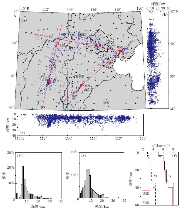
![]()
图 2 华北地震重定位结果
(a)为重定位后的震中分布,紫线为研究区东、 西部速度模型分界线,红线为3条剖面位置; (b)和(c)分别为重定位后沿纬度和经度方向的震中分布侧面图;(d)和(e)分别为重定位前和重定位后的震源深度统计图;(f)为速度模型
Figure 2. Relocation results of earthquakes in North China
(a)is epicenters distribution after relocation,purple line is the boundary between the eastern and western parts of different velocity models used in this study,red lines are locations of three profiles;(b)and(c)are side views of focal depths along the latitude and longitude directions after relocation,respectively;(d)and(e)are histograms of focal depths before and after relocation,respectively;(f)show velocity models,red and black lines represent western and eastern velocity models,respectively
![]()
图 3 重定位前(上)、 后(下)AA′,BB′和CC′剖面的深度对比图
(a)张渤地震带;(b)山西地震带;(c)唐山—邢台地震带
Figure 3. Comparison of focal depths of AA′,BB′,CC′ vertical profiles before(upper)and after(lower)relocation
(a)Zhangjiakou-Bohai seismic zone;(b)Shanxi seismic zone; (c)Tangshan--Xingtai seismic zone
![]()
图 6 华北地区磁性层平均地温梯度
Figure 6. Average thermal gradients of magnetic layer in North China
-
郭震, 陈永顺, 殷伟伟. 2015. 背景噪声面波与布格重力异常联合反演: 山西断陷带三维地壳结构[J]. 地球物理学报, 58(3): 821-831. http://www.cnki.com.cn/Article/CJFDTOTAL-DQWX201503012.htm Guo Z, Chen Y S, Yin W W. 2015. Three-dimensional crustal model of Shanxi graben from 3D joint inversion of ambient noise surface wave and Bouguer gravity anomalies[J]. Chinese Journal of Geophysics, 58(3): 821-831 (in Chinese). http://www.cnki.com.cn/Article/CJFDTOTAL-DQWX201503012.htm
何国幸, 胡玉禄, 魏嘉, 赵琳. 2009. 华北地温场特征[J]. 科技信息, (31): 35-36. http://www.cnki.com.cn/Article/CJFDTOTAL-KJXX200931647.htm He G X, Hu Y L, Wei J, Zhao L. 2009. Geothermal characteristics in North China[J]. Science and Technology Information, (31): 35-36 (in Chinese). http://www.cnki.com.cn/Article/CJFDTOTAL-KJXX200931647.htm
李红光, 王利亚, 孙刚, 张鹤翔, 李伟华. 2015. 华北地区中小地震重新定位和地震活动特征研究[J]. 地震, 35(1): 28-37. http://www.cnki.com.cn/Article/CJFDTOTAL-DIZN201501004.htm Li H G, Wang L Y, Sun G, Zhang H X, Li W H. 2015. Seismicity characterized by relocation of small to moderate earthquakes in North China[J]. Earthquake, 35(1): 28-37 (in Chinese). http://www.cnki.com.cn/Article/CJFDTOTAL-DIZN201501004.htm
李乐, 陈棋福, 陈颙. 2007. 首都圈地震活动构造成因的小震精定位分析[J]. 地球物理学进展, 22(1): 24-34. http://www.cnki.com.cn/Article/CJFDTOTAL-DQWJ200701002.htm Li L, Chen Q F, Chen Y. 2007. Relocated seismicity in big Beijing area and its tectonic implication[J]. Progress in Geophysics, 22(1): 24-34 (in Chinese). http://www.cnki.com.cn/Article/CJFDTOTAL-DQWJ200701002.htm
刘光勋, 阎凤忠. 1995. 从山西地震带看大同—阳高地震[J]. 山西地震, (1): 3-6. http://www.cnki.com.cn/Article/CJFDTOTAL-SXDZ501.000.htm Liu G X, Yan F Z. 1995. Understanding the Datong-Yanggao earthquake based on Shanxi seismic zone[J]. Earthquake Research in Shanxi, (1): 3-6 (in Chinese). http://www.cnki.com.cn/Article/CJFDTOTAL-SXDZ501.000.htm
唐有彩, 冯永革, 陈永顺, 周仕勇, 宁杰远, 魏松峤, 李鹏, 俞春泉, 范文渊, 王海洋. 2010. 山西断陷带地壳结构的接收函数研究[J]. 地球物理学报, 53(9): 2102-2109. http://www.cnki.com.cn/Article/CJFDTOTAL-DQWX201009011.htm Tang Y C, Feng Y G, Chen Y S, Zhou S Y, Ning J Y, Wei S Q, Li P, Yu C Q, Fan W Y, Wang H Y. 2010. Receiver function analysis at Shanxi rift[J]. Chinese Journal of Geophysics, 53(9): 2102-2109 (in Chinese). http://www.cnki.com.cn/Article/CJFDTOTAL-DQWX201009011.htm
王健. 2001. 1976年唐山地震成因解释的一个新模式[J]. 地震学报, 23(5): 552-557. http://www.dzxb.org/Magazine/Show?id=26983 Wang J. 2001. A new model on the cause of Tangshan earthquakes in 1976[J]. Acta Seismologica Sinica, 23(5): 552-557 (in Chinese). http://www.dzxb.org/Magazine/Show?id=26983
徐锡伟, 于贵华, 王峰, 顾梦林, 孙振国, 刘保金, 尤惠川. 2000. 1966年邢台地震群的发震构造模型: 新生断层形成?先存活断层摩擦粘滑?[J]. 中国地震, 16(4): 364-378. http://www.cnki.com.cn/Article/CJFDTOTAL-ZGZD200004007.htm Xu X W, Yu G H, Wang F, Gu M L, Sun Z G, Liu B J, You H C. 2000. Seismogenic model for the 1966 Xingtai earthquakes-nucleation of new-born fault or strick-slip of pre-existing fault?[J]. Earthquake Research in China, 16(4): 364-378 (in Chinese). http://www.cnki.com.cn/Article/CJFDTOTAL-ZGZD200004007.htm
于湘伟, 陈运泰, 张怀. 2010a. 京津唐地区中小地震重新定位[J]. 地震学报, 32(3): 257-269. http://www.dzxb.org/Magazine/Show?id=28767 Yu X W, Chen Y T, Zhang H. 2010a. Relocation of earthquakes in Beijing-Tianjin-Tangshan region with double-difference tomography technique[J]. Acta Seismologica Sinica, 32(3): 257-269 (in Chinese). http://www.dzxb.org/Magazine/Show?id=28767
于湘伟, 张怀, 陈运泰. 2010b. 华北地区地震重新定位结果分析[J]. 大地测量与地球动力学, 30(2): 29-33. http://www.cnki.com.cn/Article/CJFDTOTAL-DKXB201002008.htm Yu X W, Zhang H, Chen Y T. 2010b. Analysis of relocated earthquakes in North China region[J]. Journal of Geodesy and Geodynamics, 30(2): 29-33 (in Chinese). http://www.cnki.com.cn/Article/CJFDTOTAL-DKXB201002008.htm
张广伟, 雷建设, 谢富仁, 郭永霞, 兰从欣. 2011. 华北地区小震精定位及构造意义[J]. 地震学报, 33(6): 699-714. http://www.dzxb.org/Magazine/Show?id=28711 Zhang G W, Lei J S, Xie F R, Guo Y X, Lan C X. 2011. Precise relocation of small earthquakes occurred in North China and its tectonic implication[J]. Acta Seismologica Sinica, 33(6): 699-714 (in Chinese). http://www.dzxb.org/Magazine/Show?id=28711
赵博, 高原, 石玉涛. 2013. 用双差定位结果分析华北地区的地震活动[J]. 地震, 33(1): 12-21. http://www.cnki.com.cn/Article/CJFDTOTAL-DIZN201301003.htm Zhao B, Gao Y, Shi Y T. 2013. Relocation of small earthquakes in North China using double difference algorithm[J]. Earthquake, 33(1): 12-21 (in Chinese). http://www.cnki.com.cn/Article/CJFDTOTAL-DIZN201301003.htm
朱艾斓, 徐锡伟, 胡平, 周永胜, 林元武, 陈桂华, 甘卫军. 2005. 首都圈地区小震重新定位及其在地震构造研究中的应用[J]. 地质论评, 51(3): 268-274. http://www.cnki.com.cn/Article/CJFDTOTAL-DZLP200503008.htm Zhu A L, Xu X W, Hu P, Zhou Y S, Lin Y W, Chen G H, Gan W J. 2005. Relocation of small earthquakes in Beijing area and its implication to seismotectonics[J]. Geological Review, 51(3): 268-274 (in Chinese). http://www.cnki.com.cn/Article/CJFDTOTAL-DZLP200503008.htm
An M J, Shi Y L. 2007. Three-dimensional thermal structure of the Chinese continental crust and upper mantle[J]. Science in China: Series D, 50(10): 1441-1451. doi: 10.1007/s11430-007-0071-3
Bansal A R, Gabriel G, Dimri V P, Krawezyk C M. 2011. Estimation of depth to bottom of magnetic sources by a modified centroid method for fractal distribution of sources: An application to aeromagnetic data in Germany[J]. Geophysics, 76(3): L11-L22. doi: 10.1190/1.3560017
Bonner J L, Blackwell D D, Herrin E T. 2003. Thermal constraints on earthquake depths in California[J]. Bull Seismol Soc Am, 93(6): 2333-2354. doi: 10.1785/0120030041
Bouligand C, Glen J M G, Blakely R J. 2009. Mapping Curie temperature depth in the western United States with a fractal model for crustal magnetization[J]. J Geophys Res, 114(B11): B11104. doi: 10.1029/2009JB006494
Chen W P, Molnar P. 1983. Focal depths of intracontinental and intraplate earthquakes and their implications for the thermal and mechanical properties of the lithosphere[J]. J Geophys Res, 88(B5): 4183-4214. doi: 10.1029/JB088iB05p04183
Cho I, Kuwahara Y. 2013. Constraints on the three-dimensional thermal structure of the lower crust in the Japanese Islands[J]. Earth Planets Space, 65(8): 855-861. doi: 10.5047/eps.2013.01.005
Connard G, Couch R, Gemperle M. 1983. Analysis of aeromagnetic measurements from the Cascade Range in central Oregon[J]. Geophysics, 48(3): 376-390. doi: 10.1190/1.1441476
Fedi M, Quarta T, DeSantis A. 1997. Inherent power-law behavior of magnetic field power spectra from a Spector and Grant ensemble[J]. Geophysics, 62(4): 1143-1150. doi: 10.1190/1.1444215
Frost B R, Shive P N. 1986. Magnetic mineralogy of the lower continental crust[J]. J Geophys Res, 91(B6): 6513-6521. doi: 10.1029/JB091iB06p06513
Furlong K P, Atkinson S M. 1993. Seismicity and thermal structure along the northern San Andreas fault system, California, USA[J]. Tectonophysics, 217(1/2): 23-30. http://cn.bing.com/academic/profile?id=2009628524&encoded=0&v=paper_preview&mkt=zh-cn
Gao G M, Kang G F, Li G Q, Bai C H. 2015. Crustal magnetic anomaly in the Ordos region and its tectonic implica-tions[J]. J Asian Earth Sci, 109: 63-73. doi: 10.1016/j.jseaes.2015.04.033
Lei J S, Xie F R, Lan C X, Xing C Q, Ma S Z. 2008. Seismic images under the Beijing region inferred from P and PmP data[J]. Phys Earth Planet Inter, 168(3/4): 134-146. http://cn.bing.com/academic/profile?id=1984230822&encoded=0&v=paper_preview&mkt=zh-cn
Lei J S, Xie F R, Fan Q C, Santosh M. 2013. Seismic imaging of the deep structure under the Chinese volcanoes: An overview[J]. Phys Earth Planet Inter, 224: 104-123. doi: 10.1016/j.pepi.2013.08.008
Li C F, Shi X B, Zhou Z Y, Li J B, Geng J H, Chen B. 2010. Depths to the magnetic layer bottom in the South China Sea area and their tectonic implications[J]. Geophys J Int, 182(3): 1229-1247. doi: 10.1111/j.1365-246X.2010.04702.x
Li C F. 2011. An integrated geodynamic model of the Nankai subduction zone and neighboring regions from geophysical inversion and modeling[J]. J Geodyn, 51(1): 64-80. doi: 10.1016/j.jog.2010.08.003
Li C F, Wang J L, Zhou Z Y, Geng J H, Chen B, Yang F L, Wu J S, Yu P, Zhang X B, Zhang S W. 2012. 3D geophysical characterization of the Sulu-Dabie orogeny and its environs[J]. Phys Earth Planet Inter, 192/193(1): 35-53. http://cn.bing.com/academic/profile?id=2005313853&encoded=0&v=paper_preview&mkt=zh-cn
Li C F, Wang J, Lin J, Wang T T. 2013. Thermal evolution of the North Atlantic lithosphere: New constraints from magnetic anomaly inversion with a fractal magnetization model[J]. Geochem Geophys Geosyst, 14(12): 5078-5105. doi: 10.1002/ggge.v14.12
Li C F, Wang J. 2016. Variations in Moho and Curie depths and heat flow in Eastern and Southeastern Asia[J]. Mar Geophys Res, 37(1): 1-20. doi: 10.1007/s11001-016-9265-4
Liu M, Cui X J, Liu F T. 2004. Cenozoic rifting and volcanism in eastern China: A mantle dynamic link to the Indo-Asian collision?[J]. Tectonophysics, 393(1/2/3/4): 29-42. http://cn.bing.com/academic/profile?id=2093263440&encoded=0&v=paper_preview&mkt=zh-cn
Magistrale H. 2002. Relative contributions of crustal temperature and composition to controlling the depth of earthquakes in southern California[J]. Geophys Res Lett, 29(10): 87-1-87-4. http://cn.bing.com/academic/profile?id=1679827180&encoded=0&v=paper_preview&mkt=zh-cn
Maus S, Barckhause U, Berkenbosch H, Bournas N, Brozena J, Childers V, Dostaler F, Fairhead J D, Finn C, von Frese R R B, Gaina C, Golynsky S, Kuchs R, Luhr H, Milligan P, Mogren S, Müller R D, Olesen O, Pilkington M, Saltus R, Schreckenberger B, Thebault E, Tontini F C. 2009. A 2-arc min resolution Earth Magnetic Anomaly Grid compiled from satellite, airborne, and marine magnetic measurements[J]. Geochem Geophys Geosyst, 10(8): Q08005. http://cn.bing.com/academic/profile?id=1586341875&encoded=0&v=paper_preview&mkt=zh-cn
Meissner R, Strehlau J. 1982. Limits of stresses in continental crusts and their relation to the depth-frequency distribution of shallow earthquakes[J]. Tectonics, 1(1): 73-89. doi: 10.1029/TC001i001p00073
Pilkington M. 2007. Fractal character of oceanic crustal magnetism determined from drill hole measurements[J]. Ind J Mar Sci, 36(2): 97-104. http://nopr.niscair.res.in/bitstream/123456789/19/1/IJMS%2036%282%29%20%282007%29%2097-104.pdf
Ross H E, Blakely R J, Zoback M D. 2006. Testing the use of aeromagnetic data for the determination of Curie depth in California[J]. Geophysics, 71(5): L51-L59. doi: 10.1190/1.2335572
Shimada M. 1992. Confirmation of two types of fracture in granite deformed at temperatures to 300℃[J]. Tectonophy-sics, 211(1/2/3/4): 259-268.
Shimada M. 1993. Lithospheric strength inferred from fracture strength of rocks at high confining pressures and temperatures[J]. Tectonophysics, 217(1/2): 55-64.
Shuey R T, Schellinger D K, Tripp A C, Ai L B. 1977. Curie depth determination from aeromagnetic spectra[J]. Geophys J Int, 50(1): 75-101. doi: 10.1111/j.1365-246X.1977.tb01325.x
Sibson R H. 1982. Fault zone models, heat flow, and the depth distribution of earthquakes in the continental crust of the United States[J]. Bull Seismol Soc Am, 72(1): 151-163.
Sibson R H. 1984. Roughness at the base of the seismogenic zone: Contributing factors[J]. J Geophys Res, 89(B7): 5791-5799. doi: 10.1029/JB089iB07p05791
Tanaka A, Okubo Y, Matsubayashi O. 1999. Curie point depth based on spectrum analysis of the magnetic anomaly data in East and Southeast Asia[J]. Tectonophysics, 306(3/4): 461-470. http://cn.bing.com/academic/profile?id=2015904219&encoded=0&v=paper_preview&mkt=zh-cn
Tanaka A, Ishikawa Y. 2002. Temperature distribution and focal depth in the crust of the northeastern Japan[J]. Earth Planets Space, 54(11): 1109-1113. doi: 10.1186/BF03353310
Tanaka A, Ishikawa Y. 2005. Crustal thermal regime inferred from magnetic anomaly data and its relationship to seismogenic layer thickness: The Japanese islands case study[J]. Phys Earth Planet Inter, 152(4): 257-266. doi: 10.1016/j.pepi.2005.04.011
Tullis J, Yund R A. 1977. Experimental deformation of dry westerly granite[J]. J Geophys Res, 82(36): 5705-5718. doi: 10.1029/JB082i036p05705
Tullis J, Yund R A. 1985. Dynamic recrystallization of feldspar: A mechanism for ductile shear zone formation[J]. Geology, 13(4): 238-241. doi: 10.1130/0091-7613(1985)13<238:DROFAM>2.0.CO;2
Waldhauser F, Ellsworth W L. 2000. A double difference earthquake location algorithm: Method and application to the North Hayward fault, California[J]. Bull Seismol Soc Am, 90(6): 1353-1368. doi: 10.1785/0120000006
Wang J, Li C F. 2015. Crustal magmatism and lithospheric geothermal state of western North America and their implications for a magnetic mantle[J]. Tectonophysics, 638: 112-125. doi: 10.1016/j.tecto.2014.11.002
Yin A. 2000. Mode of Cenozoic east-west extension in Tibet suggesting a common origin of rifts in Asia during the Indo-Asian collision[J]. J Geophys Res, 105(B9): 21745-21759. doi: 10.1029/2000JB900168
Zhao D P. 2004. Global tomographic images of mantle plumes and subducting slabs: Insight into deep Earth dyna-mics[J]. Phys Earth Planet Inter, 146(1/2): 3-34.
Zhao G C, Cawood P A. 2012. Precambrian geology of China[J]. Precambrian Res, 222/223: 13-54. doi: 10.1016/j.precamres.2012.09.017
-
期刊类型引用(3)
1. 王林海,陈石. 贝叶斯重力平差算法的稳定性评估与统计检验. 华中科技大学学报(自然科学版). 2023(03): 92-99 .  百度学术
百度学术
2. 张恒磊,耿美霞,胡祥云. 基于曲波压缩的重磁异常三维反演及其应用. 石油地球物理勘探. 2023(04): 993-1001 . 百度学术
3. 程程,韩立国,翟丽娜. 基于Molchan检验的时变重力场地震预报效能评价. 地球物理学进展. 2022(06): 2233-2241 . 百度学术
其他类型引用(1)

 下载:
下载:


计量
- 文章访问数: 543
- HTML全文浏览量: 338
- PDF下载量: 68
- 被引次数: 4
