| Citation: |
Li J Y,Xu Y R,Zhang J L,Mu R Y. 2024. Change identification of coseismic surface rupture zone over time based on multi-source satellite images:A casestudy of the west of Kunlunshan Pass MS8.1 earthquake in 2001. Acta Seismologica Sinica,46(6):982−1001. DOI: 10.11939/jass.20230069

|
Coseismic surface rupture is the permanent deformation on the surface in the middle and upper parts of the earth’s crust during a strong earthquake occurred. It indicates to a certain extent the deep structural characteristics of the active faults and the pre-existing tectonic environment , so complete extraction of characteristic of coseismic surface rupture has an important influence on the understanding of geometry and structure of the active faults.
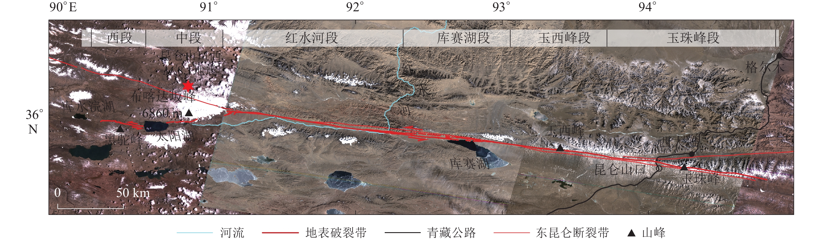
On November 14, 2001, a West Pass of Kunlunshan earthquake with magnitude of MS8.1 occurred at Hoh Xil of no man’s land in Golmud City, Qinghai Province, northern Qinghai-Xizang Plateau. The instrumental epicenter was located near the Kunlun mountains at the junction of Xinjiang Uygur Autonomous Region and Qinghai Province within higher local altitude. The strong quake destroyed the Qinghai-Xizang Railway under construction and Qinghai-Xizang Highway connecting Xining to Lhasa, causing major economic losses to the country's lifeline projects. Due to the hypoxia, harsh natural environment, and inconvenient transportation of the epicenter area which difficult to conduct extensive field surveys. It is necessary to use high-resolution satellite archived images to study the time-varying characteristics of coseismic surface rupture induced by recent strong earthquakes, which has important reference significance for conducting research on historical strong earthquake events. This paper uses multi-temporal high-resolution satellite images (with resolution of 1−6 m) covering the coseismic surface rupture zone of the 2001 MS8.1 mainshock in the west of Kunlun Pass as the main research data to discuss the changes of coseismic surface rupture zone at different segments under natural surface process and check the reasons for its changes.
We select USGS KeyHole images with a spatial resolution of 6 m as pre-earthquake images, and the multi-period image data within 20 years post- earthquake from Google Earth (1 m), ALOS (10 m), Chinese GF-2 (1 m), and GF-7 (0.6 m). We use a comprehensive method of machine-assisted visual interpretation to extract the distribution of the coseismic rupture zone. The research results show that: ① A nearly 400 km linear coseismic surface rupture zone was formed during the 2001 earthquake, no pre-existing rupture remains were found in the relatively shorter western section before the earthquake, while the fresh coseismic rupture was reoccurrence along pre-existing earthquake ruptures at the longer eastern section. ② In 2003, two years after the earthquake, the coseismic surface ruptures locating at lake surface, crossing river valleys, gullies and alluvial fans which been checked during the earthquake field survey were rapidly affected by seasonal water flow and temperature (lake ice melt) changes. In 2011, 10 years after the earthquake, the surface rupture segments gradually showed a significant fragmented distribution on the images. Usually, continuous coseismic surface rupture zones can only be identified on high-level terraces or locations far away from active alluvial fans; in 2021, 20 years after the earthquake, coseismic surface ruptures on low-level terraces are almost impossible to identify, while the rupture zones on high-level terraces are relatively intact. The total length of identifiable rupture zones sharply reduced to 64%. More than 500 coseismic rupture sections had disappeared from the images during the past 20 years. ③ The measurement of coseismic horizontal dislocation based on GF image 20 years after the earthquake shows that the distribution of horizontal dislocation still has multiple peaks with maximum measured horizontal coseismic slip of 8.6 m, which is consistent with previous field survey but slightly smaller, and this proved that high quality satellite images can be used to combine the discontinuous coseismic rupture zone to together the length.
The identification of whole coseismic surface rupture zones on images is mainly affected by the surface processes. It is also affected by the spatial resolution of the images and their acquisition time. The identification of coseismic surface rupture of strong earthquakes can rely on emergency scientific surveys and satellite and aerial image data shortly after the earthquakes. However, the identification of surface rupture zones in uninhabited areas and historical strong earthquakes mainly relies on long-elapsed time and satellite imagery. Through residual rupture zone information on older landforms, it can recover more complete surface rupture zones than can be directly observed at the surface ground. Using satellite remote sensing images, scholars can restore the rupture scale of paleo-earthquakes and historical earthquakes, the surface rupture zone can be traced back through the residual rupture traces on older landforms, which is helpful in estimating the total length of the surface rupture zone, its magnitude, etc. Our research shows that the transformation process of coseismic surface ruptures induced by strong earthquakes can be understood in detail using multi-temporal high-spatial resolution images, which provides a methodological reference for exploring a large number of active faults within the Qinghai-Xizang Plateau to assess their earthquake risk in the future.
|
陈桂华. 2010. 光学遥感影像阴影与2008年汶川地震同震地表变形的影像识别[J]. 地震地质,32(1):107–114. doi: 10.3969/j.issn.0253-4967.2010.01.011
|
|
Chen G H. 2010. Interpretational characteristics of optical remote sensing image for the co-seismic surface deformation of the 2008 Wenchuan earthquake and its relationship with imaging[J]. Seismology and Geology,32(1):107–114 (in Chinese).
|
|
陈桂华,闵伟,宋方敏,焦德成,许洪泰. 2011. 从1786年磨西地震看地震地表破裂带在不同地貌区的保存[J]. 地震地质,33(4):804–817. doi: 10.3969/j.issn.0253-4967.2011.04.006
|
|
Chen G H,Min W,Song F M,Jiao D C,Xu H T. 2011. Preservation of co-seismic surface rupture in different geomorphological settings from the study of the 1786 Moxi earthquake[J]. Seismology and Geology,33(4):804–817 (in Chinese).
|
|
陈杰,陈宇坤,丁国瑜,王赞军,田勤俭,尹功明,单新建,王志才. 2004. 2001年昆仑山口西MS8.1地震地表同震位移分布特征[J]. 地震地质,26(3):378–392.
|
|
Chen J,Chen Y K,Ding G Y,Wang Z J,Tian Q J,Yin G M,Shan X J,Wang Z C. 2004. Surficial slip distribution and segmentation of the 426-km-long surface rupture of the 14 November,2001,MS8.1 earthquake on the east Kunlun fault,Northern Tibetan Plateau,China[J]. Seismology and Geology,26(3):378–392 (in Chinese).
|
|
付碧宏,时丕龙,张之武. 2008. 四川汶川MS8.0大地震地表破裂带的遥感影像解析[J]. 地质学报,82(12):1679–1687.
|
|
Fu B H,Shi P L,Zhang Z W. 2008. Spatial characteristics of the surface rupture produced by the MS8.0 Wenchuan earthquake using high-resolution remote sensing imagery[J]. Acta Geologica Sinica,82(12):1679–1687 (in Chinese).
|
|
刘静,徐晶,偶奇,韩龙飞,王子君,邵志刚,张培震,姚文倩,王鹏. 2023. 关于1920年海原大地震震级高估的讨论[J]. 地震学报,45(4):579–596.
|
|
Liu J,Xu J,Ou Q,Han L F,Wang Z J,Shao Z G,Zhang P Z,Yao W Q,Wang P. 2023. Discussion on the overestimated magnitude of the 1920 Haiyuan earthquake[J]. Acta Seismologica Sinica,45(4):579–596 (in Chinese).
|
|
梅安新,彭望琭,秦其明,刘慧平. 2001. 遥感导论[M]. 北京:高等教育出版社:1−324.
|
|
Mei A X,Peng W L,Qin Q M,Liu H P. 2001. An Introduction to Remote Sensing[M]. Beijing:Higher Education Press:1−324 (in Chinese).
|
|
青海省地震局,中国地震局地壳应力研究所. 1999. 东昆仑活动断裂带[M]. 北京:地震出版社:127−154.
|
|
Qinghai Earthquake Administration,Institute of Crustal Stress,China Earthquake Administration. 1999. Eastern Kunlun Active Fault Zone[M]. Beijing:Seismological Press:127−154 (in Chinese).
|
|
魏永明,李剑南,陈玉,高锦风. 2021. 不同类型发震断层的同震地表破裂光学遥感特征研究[J]. 第四纪研究,41(6):1513–1531.
|
|
Wei Y M,Li J N,Chen Y,Gao J F. 2021. Research on optical remote sensing characteristics of coseismic surface rupture of different types of seismogenic faults[J]. Quaternary Sciences,41(6):1513–1531 (in Chinese).
|
|
徐锡伟,陈文彬,于贵华,马文涛,戴华光,张志坚,陈永明,何文贵,王赞军,党光明. 2002. 2001年11月14日昆仑山库赛湖地震(MS8.1)地表破裂带的基本特征[J]. 地震地质,24(1):1–13.
|
|
Xu X W,Chen W B,Yu G H,Ma W T,Dai H G,Zhang Z J,Chen Y M,He W G,Wang Z J,Dang G M. 2002. Characteristic features of the surface ruptures of the Hoh Sai Hu (Kunlunshan) earthquake (MS8.1),Northern Tibetan Plateau,China[J]. Seismology and Geology,24(1):1–13 (in Chinese).
|
|
闫世勇. 2009. 遥感在汶川地震地质灾害评估中的应用[J]. 河北工程大学学报(自然科学版),26(1):76–80. doi: 10.3969/j.issn.1673-9469.2009.01.020
|
|
Yan S Y. 2009. Remote sensing application in the geologic disaster evaluation of Wenchuan earthquake[J]. Journal of Hebei University of Engineering (Natural Science Edition),26(1):76–80 (in Chinese).
|
|
赵瑞斌,李军,向志勇,葛鸣,罗刚. 2002. 昆仑山口西8.1级地震地表破裂带西段考察[J]. 内陆地震,16(2):175–179. doi: 10.16256/j.issn.1001-8956.2002.02.016
|
|
Zhao R B,Li J,Xiang Z Y,Ge M,Luo G. 2002. Expedition on the west segment of the surface rupture zone of the MS8.1 earthquake in the West of Kunlun Mountain Pass[J]. Inland Earthquake,16(2):175–179 (in Chinese).
|
|
中国航天科技集团有限公司. 2022.中国资源卫星应用中心数据服务平台[DB/OL]
2022−01−30]. https://data.cresda.cn/#/home
|
|
China Aerospace Science and Technology Corporation. 2022.China Center for Resources Satellite Data and Application [DB/OL].[2022−01−30]. https://data.cresda.cn/#/home (in Chinese).
|
|
Antolik M,Abercrombie R E,Ekström G. 2004. The 14 November 2001 Kokoxili (Kunlunshan),Tibet,earthquake:Rupture transfer through a large extensional step-over[J]. Bull Seismol Soc Am,94(4):1173–1194. doi: 10.1785/012003180
|
|
Avouac J P,Tapponnier P. 1993. Kinematic model of active deformation in central Asia[J]. Geophys Res Lett,20(10):895–898. doi: 10.1029/93GL00128
|
|
Crippen R E. 1992. Measurement of subresolution terrain displacements using SPOT panchromatic imagery[J]. Episodes,15(1):56–61. doi: 10.18814/epiiugs/1992/v15i1/009
|
|
Fu B H,Awata Y,Du J G,Ninomiya Y,He W G. 2005. Complex geometry and segmentation of the surface rupture associated with the 14 November 2001 great Kunlun earthquake,northern Tibet,China[J]. Tectonophysics,407(1/2):43–63.
|
|
King G,Klinger Y,Bowman D,Tapponnier P. 2005. Slip-partitioned surface breaks for the MW7.8 2001 Kokoxili earthquake,China[J]. Bull Seismol Soc Am,95(2):731–738. doi: 10.1785/0120040101
|
|
Klinger Y,Xu X W,Tapponnier P,Van der Woerd J,Lasserre C,King G. 2005. High-resolution satellite imagery mapping of the surface rupture and slip distribution of the MW~7.8,14 November 2001 Kokoxili earthquake,Kunlun Fault,Northern Tibet,China[J]. Bull Seismol Soc Am,95(5):1970–1987. doi: 10.1785/0120040233
|
|
Li H B,van der Woerd J,Tapponnier P,Klinger Y,Qi X X,Yang J S,Zhu Y T. 2005. Slip rate on the Kunlun Fault at Hongshui Gou,and recurrence time of great events comparable to the 14/11/2001,MW~7.9 Kokoxili earthquake[J]. Earth Planet Sci Lett,237(1/2):285–299.
|
|
Lin A M,Kikuchi M,Fu B H. 2003. Rupture segmentation and process of the 2001 MW7.8 central Kunlun,China,earthquake[J]. Bull Seismol Soc Am,93(6):2477–2492. doi: 10.1785/0120020179
|
|
McCalpin J P. 2009. Paleoseismology[M]. 2nd ed. Burlington:Academic Press:1−613.
|
|
Meyer B,Tapponnier P,Bourjot L,Métivier F,Gaudemer Y,Peltzer G,Guo S M,Chen Z T. 1998. Crustal thickening in Gansu-Qinghai,lithospheric mantle subduction,and oblique,strike-slip controlled growth of the Tibet plateau[J]. Geophys J Int,135(1):1–47. doi: 10.1046/j.1365-246X.1998.00567.x
|
|
Michel R,Avouac J P,Taboury J. 1999. Measuring ground displacements from SAR amplitude images:Application to the Landers earthquake[J]. Geophys Res Lett,26(7):875–878. doi: 10.1029/1999GL900138
|
|
National Aeronautics and Space Administration. 2022.Alaska Satellite Facility Distributed Active Archive Centers [DB/OL]. [2022−01−30]. https://search.asf.alaska.edu/.
|
|
Tocheport A,Rivera L,van der Woerd J. 2006. A study of the 14 November 2001 Kokoxili earthquake:History and geometry of the rupture from Teleseismic data and field observations[J]. Bull Seismol Soc Am,96(5):1729–1741. doi: 10.1785/0120050200
|
|
United States Geological Survey. 2021.USGS Earth Explorer [DB/OL].[2021−09−30]. https://earthexplorer.usgs.gov/.
|
|
van der Woerd J,Ryerson F J,Tapponnier P,Meriaux A S,Gaudemer Y,Meyer B,Finkel R C,Caffee M W,Zhao G G,Xu Z Q. 2000. Uniform slip-rate along the Kunlun fault:Implications for seismic behaviour and large-scale tectonics[J]. Geophys Res Lett,27(16):2353–2356. doi: 10.1029/1999GL011292
|
|
Xu X W,Chen W B,Ma W T,Yu G H,Chen G H. 2002. Surface rupture of the Kunlunshan earthquake (MS8.1),northern Tibetan Plateau,China[J]. Seismolog Res Lett,73(6):884–892. doi: 10.1785/gssrl.73.6.884
|
|
Xu X W,Yu G H,Klinger Y,Tapponnier P,van der Woerd J. 2006. Reevaluation of surface rupture parameters and faulting segmentation of the 2001 Kunlunshan earthquake (MW7.8),northern Tibetan Plateau,China[J]. J Geophys Res:Solid Earth,111(B5):B05316.
|
|
Xu X W,Yu G H,Ma W T,Klinger Y,Tapponnier P. 2008. Rupture behavior and deformation localization of the Kunlunshan earthquake (MW7.8) and their tectonic implications[J]. Science China:Earth Science,51(10):1361–1374. doi: 10.1007/s11430-008-0099-z
|
|
Zhang P Z,Shen Z K,Wang M,Gan W J,Bürgmann R,Molnar P,Wang Q,Niu Z J,Sun J Z,Wu J C,Sun H R,You X Z. 2004. Continuous deformation of the Tibetan Plateau from global positioning system data[J]. Geology,32(9):809–812. doi: 10.1130/G20554.1
|
| Wu Yifeng, Tang Fangtou, Jiang Xudong. 2024: Seismogenic structure of the earthquake surface rupture zone along the Maisu fault. Acta Seismologica Sinica, 46(5): 751-766. DOI: 10.11939/jass.20220225 | |
| Wang Long, Liu Aiwen, Li Xiangxiu, Fan Xiaoqing, Zhang Libao, Wang Yu. 2022: Estimation of average displacement of fault surface co-seismic dislocations. Acta Seismologica Sinica, 44(5): 845-852. DOI: 10.11939/jass.20220122 | |
| Wang Yue, Zhang Jie. 2018: Pseudo 2D joint elastic waveform inversion for velocities and attenuation in the near surface. Acta Seismologica Sinica, 40(5): 595-608. DOI: 10.11939/jass.20170196 | |
| Ye Xin, Wang Jun, Qin Qiming. 2016: Damaged building detection based on GF-1 satellite remote sensing image: A case study for Nepal MS8.1 earthquake. Acta Seismologica Sinica, 38(3): 477-485. DOI: 10.11939/jass.2016.03.015. | |
| Liu Mingjun, Wang Fuyun, Jia Shixu, Han Yanjie, Li Xuemin, Feng Jianlin, Sun Hong, Xin Hailiang, Zhang Jianshi, Tao Hong, Dai Aopeng, Sun Yin, Wang Chong. 2014: Jianganlin surface fracture induced by 2013 Lushan MS7.0 earthquake. Acta Seismologica Sinica, 36(1): 129-138. DOI: 10.3969/j.issn.0253-3782.2014.01.011. | |
| Ren Yaqiong Chen Shunyun Ma Jincom sh advance. 2012: Variation of land surface temperature in Yilan-Yitongfault zone of northeastern China. Acta Seismologica Sinica, 34(5): 698-705. | |
| Hui Wangup, Zuji Qiangup, Zhuzhong Yuanup, Yanglong Wangup, Hua Zhangup, Xiang Zhaoup, Yishan Guup2stylediv c. 1991: THE DISTRIBUTION OF SEISMIC INTENSITIES AND SURFACE RUPTURE IN THE LANCANG-GENGMA (YUNNAN PROVINCE,CHIN A ) EARTHQUAKES OF NOVEMBER 6, 1988. Acta Seismologica Sinica, 13(3): 344-353. | |
| ZHOU YUNHAO, ZHUANG KUNYUAN. 1990: THE ROLE OF FAULT GOUGE IN THE DEISMOGENIC PROCESS. Acta Seismologica Sinica, 12(3): 248-256. | |
| 1988: NEAR EARTH SURFACE ANOMALIES OF THE ATMOSPHERIC ELECTRIC FIELD AND EARTHQUAKES. Acta Seismologica Sinica, 10(2): 206-212. | |
| XU HOUZE, MAO WEIJIAN, ZHANG YONGcom sh advance. 1986: THEORETICAL MODEL OF TIDAL STRAIN ON THE EARTH'S SURFACE. Acta Seismologica Sinica, 8(3): 275-284. |
| 1. |
牛云岗,麻凤海,王琼亿. 正断层对下盘影响区基坑围护桩变形的影响. 长江科学院院报. 2024(09): 130-137 .

| |
| 2. |
张恒,冯贤庆,姬广军,高铭徽,尹子熙,汪优. 钢-聚丙烯纤维混凝土衬砌与组合抗震缝抗错断性能研究. 世界地震工程. 2024(04): 76-86 .
| |
| 3. |
张恒,徐龙军,彭龙强,谢礼立. 跨断层铁路隧道精细化建模与力学分析. 地震工程与工程振动. 2024(05): 1-12 .
|
Supported by:
Beijing Renhe Information Technology Co., Ltd.


 DownLoad: